
Test: Difference between revisions
No edit summary |
No edit summary |
||
| (5 intermediate revisions by the same user not shown) | |||
| Line 17: | Line 17: | ||
= Site characteristics = | = Site characteristics = | ||
Established in 2000, Campo Ma'an National Park is located in southwestern Cameroon, bordering Equatorial Guinea and the Atlantic Ocean. The vegetation consists largely of coastal evergreen rainforest. Several species of plants have beeen recently discovered, which may be endemic ([[#R00319|BirdLife International 2020]]). In addition to gorillas (''Gorilla gorilla'') and chimpanzees (''Pan troglodytes''), other mammals found in the park include forest elephants (''Loxodonta cyclotis''), and several species of primates, including mandrills (''Mandrillus sphinx''), and black colobus (''Colobus satanas''). The African manatee (''Trichechus senegalensis'') also occurs in the western part of the park. More than 165 species of fish have been recorded, of which four are endemic to Campo Ma'an. The park is also rich in reptiles (122 species recorded), and birds (200 species recorded in the site, and 100 species recorded in adjacent areas; [[#R00319|BirdLife International 2020]]). The park was designated as an Important Bird Area in 2001 ([[#R00319|BirdLife International 2020]]).Campo Ma’an National Park is surrounded by a buffer zone of several forest management units (Unités Techniques Opérationelles – UTOs), where commercial logging, agro-industrial expansion, and infrastructure projects have intensified since 2008, affecting wildlife abundance and connectivity (Zo’obo Engolo et al. 2025) | Established in 2000, Campo Ma'an National Park is located in southwestern Cameroon, bordering Equatorial Guinea and the Atlantic Ocean. The vegetation consists largely of coastal evergreen rainforest. Several species of plants have beeen recently discovered, which may be endemic ([[#R00319|BirdLife International 2020]]). In addition to gorillas (''Gorilla gorilla'') and chimpanzees (''Pan troglodytes''), other mammals found in the park include forest elephants (''Loxodonta cyclotis''), and several species of primates, including mandrills (''Mandrillus sphinx''), and black colobus (''Colobus satanas''). The African manatee (''Trichechus senegalensis'') also occurs in the western part of the park. More than 165 species of fish have been recorded, of which four are endemic to Campo Ma'an. The park is also rich in reptiles (122 species recorded), and birds (200 species recorded in the site, and 100 species recorded in adjacent areas; [[#R00319|BirdLife International 2020]]). The park was designated as an Important Bird Area in 2001 ([[#R00319|BirdLife International 2020]]).Campo Ma’an National Park is surrounded by a buffer zone of several forest management units (Unités Techniques Opérationelles – UTOs), where commercial logging, agro-industrial expansion, and infrastructure projects have intensified since 2008, affecting wildlife abundance and connectivity ([[#R00327|Zo’obo Engolo et al. 2025]]) | ||
'''Table 1. Basic site information for Campo Ma'an National Park''' | '''Table 1. Basic site information for Campo Ma'an National Park''' | ||
| Line 274: | Line 274: | ||
= Threats = | = Threats = | ||
Areas immediately surrounding the park are being, or have been, logged ([[#R00319|BirdLife International 2020]]). Large infrastructure projects, extractives and agro-industries are putting enormous pressure on the park. They include the Kribi industrial port complex, the Memve’ele Hydropower Dam, the Mount Mammelles iron ore exploration project, the rubber plantation of Hévécam and SOCAPALM oil palm plantations, and the construction of a railway terminal to transport iron ore to the Kribi seaport ([https://wwf.panda.org/?325912/The-saving-of-Campo-Maan-National-Park WWF 2018]). There is a strong positive correlation between the number of development projects deployed near CMNP and the average number of poaching offences (Zo’obo Engolo et al. 2025). | Areas immediately surrounding the park are being, or have been, logged ([[#R00319|BirdLife International 2020]]). Large infrastructure projects, extractives and agro-industries are putting enormous pressure on the park. They include the Kribi industrial port complex, the Memve’ele Hydropower Dam, the Mount Mammelles iron ore exploration project, the rubber plantation of Hévécam and SOCAPALM oil palm plantations, and the construction of a railway terminal to transport iron ore to the Kribi seaport ([https://wwf.panda.org/?325912/The-saving-of-Campo-Maan-National-Park WWF 2018]). There is a strong positive correlation between the number of development projects deployed near CMNP and the average number of poaching offences ([[#R00327|Zo’obo Engolo et al. 2025]]). | ||
'''Table 3. Threats to apes reported for Campo Ma'an National Park''' | '''Table 3. Threats to apes reported for Campo Ma'an National Park''' | ||
| Line 449: | Line 449: | ||
= Exposure to climate change impacts = | = Exposure to climate change impacts = | ||
As part of a study on the exposure of African great ape sites to climate change impacts, Kiribou et al. (2024) extracted climate data and data on projected extreme climate impact events for the site. Climatological characteristics were derived from observation-based climate data provided by the Inter-Sectoral Impact Model Intercomparison Project (ISIMIP, www.isimip.org). Parameters were calculated as the average across each 30-year period. For 1981-2010, the EWEMBI dataset from ISIMIP2a was used. For the two future periods (2021-2050 and 2071-2099) ISIMIP2b climate data based on four CMIP5 global climate models were used. For future projections, two Representative Concentration Pathways (RCP) were used. RCP 2.6 is a scenario with strong mitigation measures in which global temperatures would likely rise below 2C. RCP 6.0 is a scenario with medium emissions in which global temperatures would likely rise up to 3C by 2100. For the number of days with heavy precipitation events, the 98th percentile of all precipitation days (>1mm/d) was calculated for the 1979-2013 reference period as a threshold for a heavy precipitation event. Then, for each year, the number of days above that threshold was derived. The figures on temperature and precipitation anomaly show the deviation from the mean temperature and mean precipitation for the 1979-2013 reference period. | As part of a study on the exposure of African great ape sites to climate change impacts, [[#R02169|Kiribou et al. (2024)]] extracted climate data and data on projected extreme climate impact events for the site. Climatological characteristics were derived from observation-based climate data provided by the Inter-Sectoral Impact Model Intercomparison Project (ISIMIP, www.isimip.org). Parameters were calculated as the average across each 30-year period. For 1981-2010, the EWEMBI dataset from ISIMIP2a was used. For the two future periods (2021-2050 and 2071-2099) ISIMIP2b climate data based on four CMIP5 global climate models were used. For future projections, two Representative Concentration Pathways (RCP) were used. RCP 2.6 is a scenario with strong mitigation measures in which global temperatures would likely rise below 2C. RCP 6.0 is a scenario with medium emissions in which global temperatures would likely rise up to 3C by 2100. For the number of days with heavy precipitation events, the 98th percentile of all precipitation days (>1mm/d) was calculated for the 1979-2013 reference period as a threshold for a heavy precipitation event. Then, for each year, the number of days above that threshold was derived. The figures on temperature and precipitation anomaly show the deviation from the mean temperature and mean precipitation for the 1979-2013 reference period. | ||
The estimated exposure to future extreme climate impact events (crop failure, drought, river flood, wildfire, tropical cyclone, and heatwave) is based on a published dataset by Lange et al. 2020 derived from ISIMIP2b data. The same global climate models and RCPs as described above were used. Within each 30-year period, the number of years with an extreme event and the average proportion of the site affected were calculated (Kiribou et al. 2024). | The estimated exposure to future extreme climate impact events (crop failure, drought, river flood, wildfire, tropical cyclone, and heatwave) is based on a published dataset by Lange et al. 2020 derived from ISIMIP2b data. The same global climate models and RCPs as described above were used. Within each 30-year period, the number of years with an extreme event and the average proportion of the site affected were calculated ([[#R02169|Kiribou et al. 2024]]). | ||
'''Table 8. Estimated past and projected climatological characteristics in Campo Ma'an National Park''' | '''Table 8. Estimated past and projected climatological characteristics in Campo Ma'an National Park''' | ||
| Line 591: | Line 591: | ||
<span id="R00327"></span>Zo'obo Engolo, G. M., Yaouba, B., Mbog Mbog, S., Ngoko, P. P., Memvi Abessolo, C. I., & Bitondo, D. (2025). Assessing the Impact of Development Projects on Wildlife Abundance in Campo-Ma’an National Park, Southern Cameroon, from 2008 to 2020. ''Journal of Environmental & Earth Sciences'', 7(9), 106-123. [https://doi.org/10.30564/jees.v7i9.10974 doi:10.30564/jees.v7i9.10974] | <span id="R00327"></span>Zo'obo Engolo, G. M., Yaouba, B., Mbog Mbog, S., Ngoko, P. P., Memvi Abessolo, C. I., & Bitondo, D. (2025). Assessing the Impact of Development Projects on Wildlife Abundance in Campo-Ma’an National Park, Southern Cameroon, from 2008 to 2020. ''Journal of Environmental & Earth Sciences'', 7(9), 106-123. [https://doi.org/10.30564/jees.v7i9.10974 doi:10.30564/jees.v7i9.10974] | ||
<span id="R02169"></span>Kiribou, R., Tehoda, P., Chukwu, O., Bempah, G., Kühl, H. S., Ferreira, J., …, & Heinicke, S. (2024). Exposure of African ape sites to climate change impacts. ''PLOS Climate'', 3(2), e0000345. [https://doi.org/10.1371/journal.pclm.0000345 doi:10.1371/journal.pclm.0000345] | |||
<span id="R02023"></span>WWF. https://www.wwf-congobasin.org/where_we_work/cameroon/campo_ma_an_programme/ | <span id="R02023"></span>WWF. https://www.wwf-congobasin.org/where_we_work/cameroon/campo_ma_an_programme/ | ||
Latest revision as of 13:03, 12 October 2026
Central Africa > Cameroon > Campo Ma'an National Park
Français | Português | Español | Bahasa Indonesia | Melayu
Summary
- Central chimpanzees (Pan troglodytes troglodytes) and western lowland gorillas (Gorilla gorilla gorilla) are present in Campo Ma'an National Park.
- In 2020, it was estimated that 718 gorillas and chimpanzees inhabit the site.
- The great ape population trend is decreasing.
- The site has a total size of 2,641 km².
- Large infrastructure projects, extractives and agro-industries are putting enormous pressure on the park.
- Conservation activities have focused on patrolling the area and habituation of gorillas to strengthen the potential for ecotourism.
Site characteristics
Established in 2000, Campo Ma'an National Park is located in southwestern Cameroon, bordering Equatorial Guinea and the Atlantic Ocean. The vegetation consists largely of coastal evergreen rainforest. Several species of plants have beeen recently discovered, which may be endemic (BirdLife International 2020). In addition to gorillas (Gorilla gorilla) and chimpanzees (Pan troglodytes), other mammals found in the park include forest elephants (Loxodonta cyclotis), and several species of primates, including mandrills (Mandrillus sphinx), and black colobus (Colobus satanas). The African manatee (Trichechus senegalensis) also occurs in the western part of the park. More than 165 species of fish have been recorded, of which four are endemic to Campo Ma'an. The park is also rich in reptiles (122 species recorded), and birds (200 species recorded in the site, and 100 species recorded in adjacent areas; BirdLife International 2020). The park was designated as an Important Bird Area in 2001 (BirdLife International 2020).Campo Ma’an National Park is surrounded by a buffer zone of several forest management units (Unités Techniques Opérationelles – UTOs), where commercial logging, agro-industrial expansion, and infrastructure projects have intensified since 2008, affecting wildlife abundance and connectivity (Zo’obo Engolo et al. 2025)
Table 1. Basic site information for Campo Ma'an National Park
| Species | Pan troglodytes troglodytes, Gorilla gorilla gorilla |
| Area | 2,641 km² |
| Coordinates | Lat: 2.389597 , Lon: 10.206030 |
| Type of site | Protected area (National Park) |
| Habitat types | Subtropical/tropical moist lowland forest, Wetlands (lakes, rivers, streams, bogs, marshes) |
| Type of governance | Governance by government |
Types of sites Governance types Habitat types
Ape status
Table 2. Ape population estimates reported for Campo Ma'an National Park
| Species | Year | Occurrence | Encounter or vistation rate (nests/km; ind/day) | Density estimate [ind./ km²] (95% CI) | Abundance estimate (95% CI) | Survey area | Sampling method | Analytical framework | Source | Comments | A.P.E.S. database ID |
|---|---|---|---|---|---|---|---|---|---|---|---|
| Pan troglodytes troglodytes & Gorilla gorilla gorilla | 2020 | 718.0 | Campo Ma'an National Park | Line transects & recces | Zo’obo Engolo et al. 2025 | ||||||
| Pan troglodytes troglodytes & Gorilla gorilla gorilla | 2014 | 1472.0 | Campo Ma'an National Park | Line transects | N'Goran 2017 | ||||||
| Pan troglodytes troglodytes | 2014 | 1.01 (0.71-1.42) | 351 (250-495) | Campo Ma'an National Park, Dipikar (348.34 km²) | Line transects | Distance sampling with survey specific decay time | Nzooh Dongmo et al. 2015 | CMR0021 | |||
| Gorilla gorilla gorilla | 2014 | 1.25 (0.70-2.23) | 436 (245-776) | Campo Ma'an National Park, Dipikar (348.34 km²) | Line transects | Distance sampling with survey specific decay time | Nzooh Dongmo et al. 2015 | CMR0021 | |||
| Pan troglodytes troglodytes & Gorilla gorilla gorilla | 2014 | 1.99 (1.47-2.70) | 694 (513-940) | Campo Ma'an National Park, Dipikar (348.34 km²) | Line transects | Distance sampling with survey specific decay time | Nzooh Dongmo et al. 2015 | CMR0021 | |||
| Gorilla gorilla gorilla | 2014 | 0.16 (0.08-0.31) | 369 (191-710) | Campo Ma'an National Park, Nord (2,266.73 km²) | Line transects | Distance sampling with survey specific decay time | Nzooh Dongmo et al. 2015 | CMR0021 | |||
| Pan troglodytes troglodytes | 2014 | 0.19 (0.11-0.34) | 440 (248-779) | Campo Ma'an National Park, Nord (2,266.73 km²) | Line transects | Distance sampling with survey specific decay time | Nzooh Dongmo et al. 2015 | CMR0021 | |||
| Gorilla gorilla gorilla | 2014 | 0.22 (0.14-0.33) | 1,000 (661-1,514) | Campo Ma'an National Park and surroundings (4,609.6 km²) | Line transects | Distance sampling with survey specific decay time | Nzooh Dongmo et al. 2015 | CMR0021 | |||
| Pan troglodytes troglodytes | 2014 | 0.26 (0.20-0.35) | 1,220 (929-1,603) | Campo Ma'an National Park and surroundings (4,609.6 km²) | Line transects | Distance sampling with survey specific decay time | Nzooh Dongmo et al. 2015 | CMR0021 | |||
| Pan troglodytes troglodytes & Gorilla gorilla gorilla | 2014 | 0.34 (0.21-0.55) | 778 (484-1,250) | Campo Ma'an National Park, Nord (2,266.73 km²) | Line transects | Distance sampling with survey specific decay time | Nzooh Dongmo et al. 2015 | CMR0021 | |||
| Pan troglodytes troglodytes & Gorilla gorilla gorilla | 2014 | 0.48 (0.38-0.60) | 2,199 (1,736-2,786) | Campo Ma'an National Park and surroundings (4,609.6 km²) | Line transects | Distance sampling with survey specific decay time | Nzooh Dongmo et al. 2015 | CMR0021 | |||
| Pan troglodytes troglodytes & Gorilla gorilla gorilla | 2008 | 1039.0 | Campo Ma'an National Park | Line transects | N'Goran 2017 | ||||||
| Gorilla gorilla gorilla | 1997-2000 | 0.20 | Campo forest | Line transects | Matthews & Matthews 2004 | ||||||
| Pan troglodytes troglodytes | 1997-2000 | 0.63-0.78 | Campo forest | Line transects | Matthews & Matthews 2004 | ||||||
| Pan troglodytes troglodytes | 1997-2000 | 0.8-1.0 | Ma'an forest | Line transects | Matthews & Matthews 2004 | ||||||
| Gorilla gorilla gorilla | 1997-2000 | Ma'an forest | Line transects | Matthews & Matthews 2004 | Gorilla density was too low to allow an estimation. |
Sampling methods Analytical frameworks
Threats
Areas immediately surrounding the park are being, or have been, logged (BirdLife International 2020). Large infrastructure projects, extractives and agro-industries are putting enormous pressure on the park. They include the Kribi industrial port complex, the Memve’ele Hydropower Dam, the Mount Mammelles iron ore exploration project, the rubber plantation of Hévécam and SOCAPALM oil palm plantations, and the construction of a railway terminal to transport iron ore to the Kribi seaport (WWF 2018). There is a strong positive correlation between the number of development projects deployed near CMNP and the average number of poaching offences (Zo’obo Engolo et al. 2025).
Table 3. Threats to apes reported for Campo Ma'an National Park
| Category | Specific threats | Threat level | Description | Year of threat |
|---|---|---|---|---|
| 2 Agriculture & aquaculture | 2.1.3 Industrial farming (including palm oil) | High (more than 70% of population affected) | The park faces growing pressure from a cluster of large-scale developments. The Kribi Deep Sea Port, Memve’élé and Ntem hydroelectric dams, HEVECAM and SOCAPALM plantations, the CAMVERT palm oil project, Sinosteel mining, and the planned Kribi-Mbalam railway all of which have contributed to rising poaching rates and habitat fragmentation (Zo’obo Engolo et al. 2025). Expansion of palm oil plantations, since 2019 (Djoko et al. 2022). | 2019-Ongoing (2025) |
| 3 Energy production & mining | 3.2.1 Industrial mining | High (more than 70% of population affected) | The park faces growing pressure from a cluster of large-scale developments. The Kribi Deep Sea Port, Memve’élé and Ntem hydroelectric dams, HEVECAM and SOCAPALM plantations, the CAMVERT palm oil project, Sinosteel mining, and the planned Kribi-Mbalam railway all of which have contributed to rising poaching rates and habitat fragmentation (Zo’obo Engolo et al. 2025). | Ongoing (2020) |
| 5 Biological resource use | 5.1 Hunting & collecting terrestrial animals | Present (unknown severity) | Hunting pressure is relatively high, but it decreased by more than 50% from 2008 to 2014 (N'Goran 2017). There are also reports that poaching of mammals increased in the park between 2011 and 2020 (Zo’obo Engolo et al. 2025). | 2008-Ongoing (2020) |
| 5 Biological resource use | 5.3 Logging & wood harvesting | Present (unknown severity) | Logging activities in the forest management units reported (Djoko et al. 2022). | 2019-Ongoing (2022) |
| 7 Natural system modifications | 7.2 Dams & water management/use | High (more than 70% of population affected) | The park faces growing pressure from a cluster of large-scale developments. The Kribi Deep Sea Port, Memve’élé and Ntem hydroelectric dams, HEVECAM and SOCAPALM plantations, the CAMVERT palm oil project, Sinosteel mining, and the planned Kribi-Mbalam railway all of which have contributed to rising poaching rates and habitat fragmentation (Zo’obo Engolo et al. 2025). | Ongoing (2020) |
Conservation activities
Table 4. Conservation activities reported for Campo Ma'an National Park
| Category | Specific activity | Description | Implementing organization(s) | Year of activity |
|---|---|---|---|---|
| 2 Counter-wildlife crime | 2.3 Conduct regular anti-poaching patrols | Park guards conduct regular patrols to halt poaching and human encroachment (WWF, WWF 2008). | MINFOF (Campo Ma’an park team); WWF; AWF; local community patrols | 2008-Ongoing (2020) |
| 5 Protection & restoration | 5.2 Legally protect ape habitat | The site is a National Park. | MINFOF | 2000-Ongoing (2026) |
| 6 Species management | 6.1 Habituate primates to human presence to reduce stress from tourists/researchers | WWF supports a gorilla habituation programme. Gorilla Habituation Project in the southwest region of the National Park, as efforts to make gorillas tolerant to human presence for research and possibly ecotourism (Collins 2022). | WWF | 2011-Ongoing (2022) |
Challenges
Table 5. Challenges reported for Campo Ma'an National Park
| Challenges | Specific challenges | Source | Year(s) |
|---|---|---|---|
| Not reported |
Enablers
Table 6. Enablers reported for Campo Ma'an National Park
| Enablers | Specific enablers | Source | Year(s) |
|---|---|---|---|
| 1 Site management | |||
| 2 Resources and capacity | 2.6 External partnerships that add expertise or resources | Collins 2022 | Ongoing (2022) |
| 3 Engaged community | |||
| 4 Institutional support | |||
| 5 Ecological context | |||
| 6 Safety and stability |
Research activities
Documented behaviours
Table 7. Behaviours documented for Campo Ma'an National Park
| Category | Behavior | Observation type | Prevalence | Observation dates | Source | Habituation | Species | Comment |
|---|---|---|---|---|---|---|---|---|
| Not reported |
Exposure to climate change impacts
As part of a study on the exposure of African great ape sites to climate change impacts, Kiribou et al. (2024) extracted climate data and data on projected extreme climate impact events for the site. Climatological characteristics were derived from observation-based climate data provided by the Inter-Sectoral Impact Model Intercomparison Project (ISIMIP, www.isimip.org). Parameters were calculated as the average across each 30-year period. For 1981-2010, the EWEMBI dataset from ISIMIP2a was used. For the two future periods (2021-2050 and 2071-2099) ISIMIP2b climate data based on four CMIP5 global climate models were used. For future projections, two Representative Concentration Pathways (RCP) were used. RCP 2.6 is a scenario with strong mitigation measures in which global temperatures would likely rise below 2C. RCP 6.0 is a scenario with medium emissions in which global temperatures would likely rise up to 3C by 2100. For the number of days with heavy precipitation events, the 98th percentile of all precipitation days (>1mm/d) was calculated for the 1979-2013 reference period as a threshold for a heavy precipitation event. Then, for each year, the number of days above that threshold was derived. The figures on temperature and precipitation anomaly show the deviation from the mean temperature and mean precipitation for the 1979-2013 reference period.
The estimated exposure to future extreme climate impact events (crop failure, drought, river flood, wildfire, tropical cyclone, and heatwave) is based on a published dataset by Lange et al. 2020 derived from ISIMIP2b data. The same global climate models and RCPs as described above were used. Within each 30-year period, the number of years with an extreme event and the average proportion of the site affected were calculated (Kiribou et al. 2024).
Table 8. Estimated past and projected climatological characteristics in Campo Ma'an National Park
| Value | 1981-2010 | 2021-2050, RCP 2.6 | 2021-2050, RCP 6.0 | 2071-2099, RCP 2.6 | 2071-2099, RCP 6.0 |
|---|---|---|---|---|---|
| Mean temperature [C] | 25.1 | 26.2 | 26.1 | 26.4 | 27.5 |
| Annual precipitation [mm] | 3002 | 3094 | 3126 | 3183 | 3222 |
| Max no. consecutive dry days (per year) | 12.2 | 6.8 | 8.4 | 5.9 | 9.9 |
| No. days with heavy precipitation (per year) | 7 | 8.2 | 8.9 | 9.5 | 11.4 |
Table 9. Projected exposure of apes to extreme climate impact events in Campo Ma'an National Park
| Type | No. of years with event (2021-2050, RCP 2.6) | % of site exposed (2021-2050, RCP 2.6) | No. of years with event (2021-2050, RCP 6.0) | % of site exposed (2021-2050, RCP 6.0) | No. of years with event (2070-2099, RCP 2.6) | % of site exposed (2070-2099, RCP 2.6) | No. of years with event (2070-2099, RCP 6.0) | % of site exposed (2070-2099, RCP 6.0) |
|---|---|---|---|---|---|---|---|---|
| Crop failure | 5 | 0.01 | 4.5 | 0.01 | 5 | 0.01 | 21.5 | 0.01 |
| Drought | 0 | 0 | 0 | 0 | 0 | 0 | 0 | 0 |
| Heatwave | 8 | 100 | 7.5 | 100 | 11.5 | 100 | 17.5 | 100 |
| River flood | 2 | 1.12 | 2 | 1.91 | 1 | 0.77 | 4.5 | 0.14 |
| Tropical cyclone | 0 | 0 | 0 | 0 | 0 | 0 | 0 | 0 |
| Wildfire | 26.75 | 0.15 | 28 | 0.21 | 25.75 | 0.14 | 28 | 0.23 |
-
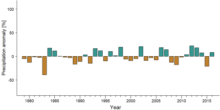
Precipitation anomaly in Campo Ma'an National Park -
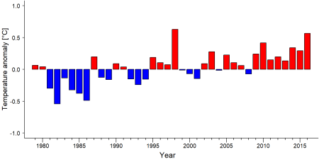
Temperature anomaly in Campo Ma'an National Park


External links
References
BirdLife International. (2020). Important Bird Areas factsheet: Campo Ma'an complex. Retrieved November 25, 2020, from http://www.birdlife.org
Collins, E. (2022). Occupancy and activity of sympatric central chimpanzee (Pan troglodytes troglodytes) and western lowland gorilla (Gorilla gorilla gorilla) in a multi-use landscape, Campo Ma’an Conservation Area, Southern Cameroon [Master’s thesis, Concordia University]. Spectrum Research Repository. https://spectrum.library.concordia.ca/id/eprint/991723/
Djoko, I. B., Weladji, R. B., Granados, A., Paré, P., & Body, G. (2022). Fruit Availability Influences Forest Elephant Habitat Use in a Human Dominated Landscape, Campo-Ma’an, Southern Cameroon. Tropical Conservation Science, 15, 1-12. doi:10.1177/19400829221117053
Matthews, A., & Matthews, A. (2004). Survey of gorillas ( Gorilla gorilla gorilla ) and chimpanzees ( Pan troglodytes troglodytes ) in Southwestern Cameroon. Primates, 45(1), 15-24. doi:10.1007/s10329-003-0058-4
N’Goran, K. P. (2017). Summary report on WWF biomonitoring activities from 2014 to 2016: Status of forest elephant and great apes in Central Africa priority sites.
Nzooh Dongmo, Z., N'Goran, K. P., Fondja, C., & Nkono, J. (2015). EVALUATION DE LA DYNAMIQUE DES POPULATIONS DE GRANDS ET MOYENS MAMMIFERES DANS LE DOMAINE FORESTIER PERMANENT DE L’UNITE TECHNIQUE OPERATIONNELLE CAMPO MA’AN. WWF Regional Office for Africa and MINFOF, Service de Conservation du Parc National de Campo Ma’an.
World Wide Fund for Nature. (2008). Biological assessment of Campo Ma’an National Park, South Cameroon. WWF Cameroon Programme Office. https://awsassets.panda.org/downloads/kz_3_anglais_final.pdf
World Wide Fund for Nature. (2018). The saving of Campo Ma’an National Park. https://wwf.panda.org/?325912/The-saving-of-Campo-Maan-National-Park
Zo'obo Engolo, G. M., Yaouba, B., Mbog Mbog, S., Ngoko, P. P., Memvi Abessolo, C. I., & Bitondo, D. (2025). Assessing the Impact of Development Projects on Wildlife Abundance in Campo-Ma’an National Park, Southern Cameroon, from 2008 to 2020. Journal of Environmental & Earth Sciences, 7(9), 106-123. doi:10.30564/jees.v7i9.10974
Kiribou, R., Tehoda, P., Chukwu, O., Bempah, G., Kühl, H. S., Ferreira, J., …, & Heinicke, S. (2024). Exposure of African ape sites to climate change impacts. PLOS Climate, 3(2), e0000345. doi:10.1371/journal.pclm.0000345
WWF. https://www.wwf-congobasin.org/where_we_work/cameroon/campo_ma_an_programme/
Page created by: APES Atlas Team Date: 2020-12-06
Page updated by: Onella Mundi Date: 2025-10-10