
Boi Tano Forest Reserve: Difference between revisions
No edit summary |
No edit summary Tag: Manual revert |
||
| (4 intermediate revisions by the same user not shown) | |||
| Line 17: | Line 17: | ||
= Site characteristics = | = Site characteristics = | ||
The reserve is located in southwestern Ghana, forming a continuous forest block with Tano Nimiri Forest Reserve in the northeast. It was declared a forest reserve in 1967 (Gatti 2009). The vegetation is mainly wet evergreen forest. Access to the reserve is difficult because of the many watercourses, with two main rivers, the Tano and the Bisao, crossing the reserve and resulting in much swamp habitat (BirdLife International 2022). | The reserve is located in southwestern Ghana, forming a continuous forest block with Tano Nimiri Forest Reserve in the northeast. It was declared a forest reserve in 1967 ([[#R00183|Gatti 2009]]). The vegetation is mainly wet evergreen forest. Access to the reserve is difficult because of the many watercourses, with two main rivers, the Tano and the Bisao, crossing the reserve and resulting in much swamp habitat ([[#R00182|BirdLife International 2022]]). | ||
'''Table 1. Basic site information for Boi Tano Forest Reserve''' | '''Table 1. Basic site information for Boi Tano Forest Reserve''' | ||
| Line 44: | Line 44: | ||
= Ape status = | = Ape status = | ||
During a rapid survey in 2009, no signs of chimpanzees were documented; however, hunters reported chimpanzee sightings and signs, and a population may still exist in the contact zone between Tano-Nimiri and Boi Tano (Gatti 2009). | During a rapid survey in 2009, no signs of chimpanzees were documented; however, hunters reported chimpanzee sightings and signs, and a population may still exist in the contact zone between Tano-Nimiri and Boi Tano ([[#R00183|Gatti 2009]]). | ||
'''Table 2. Ape population estimates reported for Boi Tano Forest Reserve''' | '''Table 2. Ape population estimates reported for Boi Tano Forest Reserve''' | ||
| Line 70: | Line 70: | ||
|Reconnaissance walk | |Reconnaissance walk | ||
| | | | ||
|Gatti 2009 | |[[#R00183|Gatti 2009]] | ||
|survey effort: 11.55 km | |survey effort: 11.55 km | ||
| | |GHA0001, GHA0007<div class="mw-collapsible mw-collapsed" data-expandtext="+5 more" data-collapsetext="less">GHA0012, GHA0024, GHA0027, GHA0028, GHA0029</div> | ||
|} | |} | ||
| Line 92: | Line 92: | ||
|2.1 Annual & perennial non-timber crops | |2.1 Annual & perennial non-timber crops | ||
|Present (unknown severity) | |Present (unknown severity) | ||
|There are a few authorised farms in the reserve (BirdLife International 2022). | |There are a few authorised farms in the reserve ([[#R00182|BirdLife International 2022]]). | ||
|Ongoing (2022) | |Ongoing (2022) | ||
|- | |- | ||
| Line 98: | Line 98: | ||
|5.1 Hunting & collecting terrestrial animals | |5.1 Hunting & collecting terrestrial animals | ||
|High (more than 70% of population affected) | |High (more than 70% of population affected) | ||
|High abundance of hunting signs and low encounter of mammal species, especially large (Gatti 2009). | |High abundance of hunting signs and low encounter of mammal species, especially large ([[#R00183|Gatti 2009]]). | ||
|Ongoing (2009) | |Ongoing (2009) | ||
|- | |- | ||
| Line 104: | Line 104: | ||
|5.3 Logging & wood harvesting | |5.3 Logging & wood harvesting | ||
|Present (unknown severity) | |Present (unknown severity) | ||
|The entire reserve was under logging concession prior to its designation as a reserve in 1967; logging was last recorded in 1980 (BirdLife International 2022). The southern part of the reserve has been more heavily logged (Gatti 2009). | |The entire reserve was under logging concession prior to its designation as a reserve in 1967; logging was last recorded in 1980 ([[#R00182|BirdLife International 2022]]). The southern part of the reserve has been more heavily logged ([[#R00183|Gatti 2009]]). | ||
|2009-Ongoing (2022) | |2009-Ongoing (2022) | ||
|} | |} | ||
| Line 214: | Line 214: | ||
= Exposure to climate change impacts = | = Exposure to climate change impacts = | ||
As part of a study on the exposure of African great ape sites to climate change impacts, Kiribou et al. | As part of a study on the exposure of African great ape sites to climate change impacts, [[#R02155|Kiribou et al. (2024)]] extracted climate data and data on projected extreme climate impact events for the site. Climatological characteristics were derived from observation-based climate data provided by the Inter-Sectoral Impact Model Intercomparison Project (ISIMIP, www.isimip.org). Parameters were calculated as the average across each 30-year period. For 1981-2010, the EWEMBI dataset from ISIMIP2a was used. For the two future periods (2021-2050 and 2071-2099) ISIMIP2b climate data based on four CMIP5 global climate models were used. For future projections, two Representative Concentration Pathways (RCP) were used. RCP 2.6 is a scenario with strong mitigation measures in which global temperatures would likely rise below 2C. RCP 6.0 is a scenario with medium emissions in which global temperatures would likely rise up to 3C by 2100. For the number of days with heavy precipitation events, the 98th percentile of all precipitation days (>1mm/d) was calculated for the 1979-2013 reference period as a threshold for a heavy precipitation event. Then, for each year, the number of days above that threshold was derived. The figures on temperature and precipitation anomaly show the deviation from the mean temperature and mean precipitation for the 1979-2013 reference period. | ||
The estimated exposure to future extreme climate impact events (crop failure, drought, river flood, wildfire, tropical cyclone, and heatwave) is based on a published dataset by Lange et al. 2020 derived from ISIMIP2b data. The same global climate models and RCPs as described above were used. Within each 30-year period, the number of years with an extreme event and the average proportion of the site affected were calculated ( | The estimated exposure to future extreme climate impact events (crop failure, drought, river flood, wildfire, tropical cyclone, and heatwave) is based on a published dataset by Lange et al. 2020 derived from ISIMIP2b data. The same global climate models and RCPs as described above were used. Within each 30-year period, the number of years with an extreme event and the average proportion of the site affected were calculated ([[#R02155|Kiribou et al. 2024]]). | ||
'''Table 8. Estimated past and projected climatological characteristics in Boi Tano Forest Reserve''' | '''Table 8. Estimated past and projected climatological characteristics in Boi Tano Forest Reserve''' | ||
| Line 339: | Line 339: | ||
= References = | = References = | ||
BirdLife International. (2022). Important Bird Areas factsheet: Boin Tano Forest Reserve. http://www.birdlife.org < | <span id="R00182"></span>BirdLife International. (2022). Important Bird Areas factsheet: Boin Tano Forest Reserve. http://www.birdlife.org | ||
<span id="R00183"></span>Gatti, S. (2009). Mammal surveys and capacity building for the Wildlife Wood Project—Ghana. Unpublished report to the WWP-Ghana. | |||
<span id="R02155"></span>Kiribou, R., Tehoda, P., Chukwu, O., Bempah, G., Kühl, H. S., Ferreira, J., …, & Heinicke, S. (2024). Exposure of African ape sites to climate change impacts. ''PLOS Climate'', 3(2), e0000345. [https://doi.org/10.1371/journal.pclm.0000345 doi:10.1371/journal.pclm.0000345] | |||
'''Page created by: '''APES Atlas Team''' Date:''' 2022-03-18 | '''Page created by: '''APES Atlas Team''' Date:''' 2022-03-18 | ||
Latest revision as of 17:52, 15 October 2026
West Africa > Ghana > Boi Tano Forest Reserve
Français | Português | Español | Bahasa Indonesia | Melayu
Summary
- Western chimpanzees (Pan troglodytes verus) may be present in Boi Tano Forest Reserve.
- No chimpanzees were recorded in the last survey.
- The chimpanzee population trend is decreasing.
- The site has a total size of 129 km².
- Key threats to chimpanzees are hunting and logging.
- Conservation activities are not documented.
Site characteristics
The reserve is located in southwestern Ghana, forming a continuous forest block with Tano Nimiri Forest Reserve in the northeast. It was declared a forest reserve in 1967 (Gatti 2009). The vegetation is mainly wet evergreen forest. Access to the reserve is difficult because of the many watercourses, with two main rivers, the Tano and the Bisao, crossing the reserve and resulting in much swamp habitat (BirdLife International 2022).
Table 1. Basic site information for Boi Tano Forest Reserve
| Species | Pan troglodytes verus |
| Area | 129 km² |
| Coordinates | Lat: 5.506396 , Lon: -2.638998 |
| Type of site | Protected area (Forest Reserve) |
| Habitat types | Subtropical/tropical moist lowland forest |
| Type of governance |
Types of sites Governance types Habitat types
Ape status
During a rapid survey in 2009, no signs of chimpanzees were documented; however, hunters reported chimpanzee sightings and signs, and a population may still exist in the contact zone between Tano-Nimiri and Boi Tano (Gatti 2009).
Table 2. Ape population estimates reported for Boi Tano Forest Reserve
| Species | Year | Occurrence | Encounter or vistation rate (nests/km; ind/day) | Density estimate [ind./ km²] (95% CI) | Abundance estimate (95% CI) | Survey area | Sampling method | Analytical framework | Source | Comments | A.P.E.S. database ID |
|---|---|---|---|---|---|---|---|---|---|---|---|
| Pan troglodytes verus | 2009 | 0 | Boi Tano Forest Reserve | Reconnaissance walk | Gatti 2009 | survey effort: 11.55 km | GHA0001, GHA0007 GHA0012, GHA0024, GHA0027, GHA0028, GHA0029
|
Sampling methods Analytical frameworks
Threats
Table 3. Threats to apes reported for Boi Tano Forest Reserve
| Category | Specific threats | Threat level | Description | Year of threat |
|---|---|---|---|---|
| 2 Agriculture & aquaculture | 2.1 Annual & perennial non-timber crops | Present (unknown severity) | There are a few authorised farms in the reserve (BirdLife International 2022). | Ongoing (2022) |
| 5 Biological resource use | 5.1 Hunting & collecting terrestrial animals | High (more than 70% of population affected) | High abundance of hunting signs and low encounter of mammal species, especially large (Gatti 2009). | Ongoing (2009) |
| 5 Biological resource use | 5.3 Logging & wood harvesting | Present (unknown severity) | The entire reserve was under logging concession prior to its designation as a reserve in 1967; logging was last recorded in 1980 (BirdLife International 2022). The southern part of the reserve has been more heavily logged (Gatti 2009). | 2009-Ongoing (2022) |
Conservation activities
Challenges
Table 5. Challenges reported for Boi Tano Forest Reserve
| Challenges | Specific challenges | Source | Year(s) |
|---|---|---|---|
| Not reported |
Enablers
Table 6. Enablers reported for Boi Tano Forest Reserve
| Enablers | Specific enablers | Source | Year(s) |
|---|---|---|---|
| 1 Site management | |||
| 2 Resources and capacity | |||
| 3 Engaged community | |||
| 4 Institutional support | |||
| 5 Ecological context | |||
| 6 Safety and stability |
Research activities
Documented behaviours
Table 7. Behaviours documented for Boi Tano Forest Reserve
| Category | Behavior | Observation type | Prevalence | Observation dates | Source | Habituation | Species | Comment |
|---|---|---|---|---|---|---|---|---|
| Not reported |
Exposure to climate change impacts
As part of a study on the exposure of African great ape sites to climate change impacts, Kiribou et al. (2024) extracted climate data and data on projected extreme climate impact events for the site. Climatological characteristics were derived from observation-based climate data provided by the Inter-Sectoral Impact Model Intercomparison Project (ISIMIP, www.isimip.org). Parameters were calculated as the average across each 30-year period. For 1981-2010, the EWEMBI dataset from ISIMIP2a was used. For the two future periods (2021-2050 and 2071-2099) ISIMIP2b climate data based on four CMIP5 global climate models were used. For future projections, two Representative Concentration Pathways (RCP) were used. RCP 2.6 is a scenario with strong mitigation measures in which global temperatures would likely rise below 2C. RCP 6.0 is a scenario with medium emissions in which global temperatures would likely rise up to 3C by 2100. For the number of days with heavy precipitation events, the 98th percentile of all precipitation days (>1mm/d) was calculated for the 1979-2013 reference period as a threshold for a heavy precipitation event. Then, for each year, the number of days above that threshold was derived. The figures on temperature and precipitation anomaly show the deviation from the mean temperature and mean precipitation for the 1979-2013 reference period.
The estimated exposure to future extreme climate impact events (crop failure, drought, river flood, wildfire, tropical cyclone, and heatwave) is based on a published dataset by Lange et al. 2020 derived from ISIMIP2b data. The same global climate models and RCPs as described above were used. Within each 30-year period, the number of years with an extreme event and the average proportion of the site affected were calculated (Kiribou et al. 2024).
Table 8. Estimated past and projected climatological characteristics in Boi Tano Forest Reserve
| Value | 1981-2010 | 2021-2050, RCP 2.6 | 2021-2050, RCP 6.0 | 2071-2099, RCP 2.6 | 2071-2099, RCP 6.0 |
|---|---|---|---|---|---|
| Mean temperature [C] | 27 | 28 | 27.9 | 28.2 | 29.3 |
| Annual precipitation [mm] | 1453 | 1399 | 1456 | 1409 | 1480 |
| Max no. consecutive dry days (per year) | 26 | 21.9 | 23.8 | 23.3 | 24.4 |
| No. days with heavy precipitation (per year) | 6.8 | 6.2 | 7.1 | 6.5 | 8.8 |
Table 9. Projected exposure of apes to extreme climate impact events in Boi Tano Forest Reserve
| Type | No. of years with event (2021-2050, RCP 2.6) | % of site exposed (2021-2050, RCP 2.6) | No. of years with event (2021-2050, RCP 6.0) | % of site exposed (2021-2050, RCP 6.0) | No. of years with event (2070-2099, RCP 2.6) | % of site exposed (2070-2099, RCP 2.6) | No. of years with event (2070-2099, RCP 6.0) | % of site exposed (2070-2099, RCP 6.0) |
|---|---|---|---|---|---|---|---|---|
| Crop failure | 3 | 4.53 | 0.5 | 1.13 | 2 | 4.53 | 2.5 | 4.53 |
| Drought | 2.5 | 100 | 1.25 | 100 | 0.75 | 25 | 1.25 | 100 |
| Heatwave | 10.5 | 100 | 10.5 | 100 | 10 | 50 | 4.5 | 100 |
| River flood | 0.5 | 0.93 | 0.5 | 0.15 | 0.5 | 0.01 | 1 | 3.66 |
| Tropical cyclone | 0 | 0 | 0 | 0 | 0 | 0 | 0.5 | 0.67 |
| Wildfire | 30 | 0.29 | 30 | 0.27 | 29 | 0.3 | 29 | 0.28 |
-
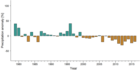
Precipitation anomaly in Boi Tano Forest Reserve -
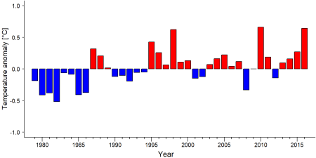
Temperature anomaly in Boi Tano Forest Reserve


External links
References
BirdLife International. (2022). Important Bird Areas factsheet: Boin Tano Forest Reserve. http://www.birdlife.org
Gatti, S. (2009). Mammal surveys and capacity building for the Wildlife Wood Project—Ghana. Unpublished report to the WWP-Ghana.
Kiribou, R., Tehoda, P., Chukwu, O., Bempah, G., Kühl, H. S., Ferreira, J., …, & Heinicke, S. (2024). Exposure of African ape sites to climate change impacts. PLOS Climate, 3(2), e0000345. doi:10.1371/journal.pclm.0000345
Page created by: APES Atlas Team Date: 2022-03-18