
Messok Dja: Difference between revisions
No edit summary |
No edit summary Tag: Manual revert |
||
| (8 intermediate revisions by the same user not shown) | |||
| Line 14: | Line 14: | ||
* Conservation activities have not been documented. | * Conservation activities have not been documented. | ||
* Messok Dja is part of the Tri-National Dja-Odzala-Minkebe (TRIDOM) landscape. | * Messok Dja is part of the Tri-National Dja-Odzala-Minkebe (TRIDOM) landscape. | ||
= Site characteristics = | = Site characteristics = | ||
The site is located in northwestern Republic of Congo. Messok Dja is part of the Tri-National Dja-Odzala-Minkebe (TRIDOM) landscape, one of the most intact forest blocks remaining in the Congo Basin. A biodiversity survey by WWF found the dense forest in Messok Dja to be an important migration corridor for animals between National Parks in Cameroon and Republic of Congo (WWF 2018). Indigenous people, especially the Baka, depend on the Messok Dja forest for food, medicine, housing, and more. Messok Dja forest is currently part of two commercial logging operations (WWF 2018). | The site is located in northwestern Republic of Congo. Messok Dja is part of the Tri-National Dja-Odzala-Minkebe (TRIDOM) landscape, one of the most intact forest blocks remaining in the Congo Basin. A biodiversity survey by WWF found the dense forest in Messok Dja to be an important migration corridor for animals between National Parks in Cameroon and Republic of Congo ([[#R01207|WWF 2018]]). Indigenous people, especially the Baka, depend on the Messok Dja forest for food, medicine, housing, and more. Messok Dja forest is currently part of two commercial logging operations ([[#R01207|WWF 2018]]). | ||
'''Table 1. Basic site information for Messok Dja''' | '''Table 1. Basic site information for Messok Dja''' | ||
| Line 44: | Line 41: | ||
[[Types of sites]] [[Governance types]] [[Habitat types]] | [[Types of sites]] [[Governance types]] [[Habitat types]] | ||
= Ape status = | = Ape status = | ||
| Line 64: | Line 62: | ||
|- | |- | ||
|''Pan troglodytes troglodytes'' & ''Gorilla gorilla gorilla'' | |''Pan troglodytes troglodytes'' & ''Gorilla gorilla gorilla'' | ||
| | |2016 | ||
| | | | ||
| | | | ||
| | | | ||
| | |2938.0 | ||
|Messok Dja forest | |Messok Dja forest | ||
|Line transects | |Line transects | ||
| | | | ||
|N'Goran 2017 | |[[#R01206|N'Goran 2017]] | ||
| | | | ||
| | | | ||
|- | |- | ||
|''Pan troglodytes troglodytes | |''Pan troglodytes troglodytes'' | ||
| | |2013 | ||
| | | | ||
| | | | ||
| | |0.39 (0.23-0.65) | ||
| | |595.0 | ||
|Messok Dja forest | |Messok Dja forest | ||
|Line transects | |Line transects & recces | ||
| | |Distance sampling | ||
| | |[[#R01205|Mantsila 2013]] | ||
| | | | ||
| | | | ||
| Line 98: | Line 96: | ||
|Line transects & recces | |Line transects & recces | ||
|Distance sampling | |Distance sampling | ||
|Mantsila 2013 | |[[#R01205|Mantsila 2013]] | ||
| | | | ||
| | | | ||
|- | |- | ||
|''Pan troglodytes troglodytes'' | |''Pan troglodytes troglodytes'' & ''Gorilla gorilla gorilla'' | ||
|2013 | |2013 | ||
| | | | ||
| | | | ||
| | | | ||
|2190.0 | |||
|Messok Dja forest | |Messok Dja forest | ||
|Line transects | |Line transects | ||
| | | | ||
| | |[[#R01206|N'Goran 2017]] | ||
| | | | ||
| | | | ||
| Line 117: | Line 115: | ||
[[Sampling methods]] [[Analytical frameworks]] | [[Sampling methods]] [[Analytical frameworks]] | ||
= Threats = | = Threats = | ||
Poaching, the spread of artisanal and semi-industrial gold mining and illegal logging are important threats in the Messok Dja forest. The discovery of iron deposits across the region and the planned development of the Chollet hydropower dam in the Dja river also pose additional pressures (WWF 2019). | Poaching, the spread of artisanal and semi-industrial gold mining and illegal logging are important threats in the Messok Dja forest. The discovery of iron deposits across the region and the planned development of the Chollet hydropower dam in the Dja river also pose additional pressures ([[#R01208|WWF 2019]]). | ||
'''Table 3. Threats to apes reported for Messok Dja''' | '''Table 3. Threats to apes reported for Messok Dja''' | ||
| Line 128: | Line 127: | ||
!Description | !Description | ||
!Year of threat | !Year of threat | ||
|- | |||
|3 Energy production & mining | |||
|3.2 Mining & quarrying | |||
|Present (unknown severity) | |||
|Artisanal and semi-industrial gold mining ([[#R01208|WWF 2019]]). | |||
|Ongoing (2019) | |||
|- | |- | ||
|5 Biological resource use | |5 Biological resource use | ||
|5.1 Hunting & collecting terrestrial animals | |5.1 Hunting & collecting terrestrial animals | ||
|Low (up to 30% of population affected) | |Low (up to 30% of population affected) | ||
|Low hunting pressure was recorded exclusively in the Messok-Dja forests. On average, approximately three signs of human activity were detected per kilometer walked, while one sign of hunting was observed every two kilometers (N’Goran 2017). | |Low hunting pressure was recorded exclusively in the Messok-Dja forests. On average, approximately three signs of human activity were detected per kilometer walked, while one sign of hunting was observed every two kilometers ([[#R01206|N’Goran 2017]]). | ||
|2013-Ongoing (2017) | |2013-Ongoing (2017) | ||
|- | |- | ||
| Line 138: | Line 143: | ||
|5.3 Logging & wood harvesting | |5.3 Logging & wood harvesting | ||
|Medium (30-70% of population affected) | |Medium (30-70% of population affected) | ||
|The indicators of human presence found in the area are mainly related to forestry activities (counting and logging) rather than hunting (Mantsila 2013). | |The indicators of human presence found in the area are mainly related to forestry activities (counting and logging) rather than hunting ([[#R01205|Mantsila 2013]]). | ||
|Ongoing (2013) | |Ongoing (2013) | ||
|} | |} | ||
[[Threats]] | [[Threats]] | ||
= Conservation activities = | = Conservation activities = | ||
| Line 166: | Line 167: | ||
|1 Site management | |1 Site management | ||
|1.1 Need for improved leadership | |1.1 Need for improved leadership | ||
|Mantsila, 2013 | |[[#R01205|Mantsila, 2013]] | ||
|Ongoing (2013) | |Ongoing (2013) | ||
|- | |- | ||
|2 Resources and capacity | |2 Resources and capacity | ||
|2.1 Lack of capacity/training | |2.1 Lack of capacity/training | ||
|Mantsila, 2013 | |[[#R01205|Mantsila, 2013]] | ||
|Ongoing (2013) | |Ongoing (2013) | ||
|- | |- | ||
|2 Resources and capacity | |2 Resources and capacity | ||
|2.3 General lack of funding | |2.3 General lack of funding | ||
|Mantsila, 2013 | |[[#R01205|Mantsila, 2013]] | ||
|Ongoing (2013) | |Ongoing (2013) | ||
|- | |- | ||
|2 Resources and capacity | |2 Resources and capacity | ||
|2.6 Lack of biomonitoring/survey data | |2.6 Lack of biomonitoring/survey data | ||
|Mantsila, 2013 | |[[#R01205|Mantsila, 2013]] | ||
|Ongoing (2013) | |Ongoing (2013) | ||
|- | |- | ||
|4 Institutional support | |4 Institutional support | ||
|4.3 Lack of protected area status | |4.3 Lack of protected area status | ||
|Mantsila, 2013 | |[[#R01205|Mantsila, 2013]] | ||
|Ongoing (2013) | |Ongoing (2013) | ||
|} | |} | ||
[[Challenges]] | [[Challenges]] | ||
= Enablers = | = Enablers = | ||
| Line 234: | Line 236: | ||
[[Enablers]] | [[Enablers]] | ||
= Research activities = | = Research activities = | ||
| Line 266: | Line 270: | ||
[[Behaviours]] | [[Behaviours]] | ||
= Exposure to climate change impacts = | = Exposure to climate change impacts = | ||
As part of a study on the exposure of African great ape sites to climate change impacts, Kiribou et al. | As part of a study on the exposure of African great ape sites to climate change impacts, [[#R02263|Kiribou et al. (2024)]] extracted climate data and data on projected extreme climate impact events for the site. Climatological characteristics were derived from observation-based climate data provided by the Inter-Sectoral Impact Model Intercomparison Project (ISIMIP, www.isimip.org). Parameters were calculated as the average across each 30-year period. For 1981-2010, the EWEMBI dataset from ISIMIP2a was used. For the two future periods (2021-2050 and 2071-2099) ISIMIP2b climate data based on four CMIP5 global climate models were used. For future projections, two Representative Concentration Pathways (RCP) were used. RCP 2.6 is a scenario with strong mitigation measures in which global temperatures would likely rise below 2C. RCP 6.0 is a scenario with medium emissions in which global temperatures would likely rise up to 3C by 2100. For the number of days with heavy precipitation events, the 98th percentile of all precipitation days (>1mm/d) was calculated for the 1979-2013 reference period as a threshold for a heavy precipitation event. Then, for each year, the number of days above that threshold was derived. The figures on temperature and precipitation anomaly show the deviation from the mean temperature and mean precipitation for the 1979-2013 reference period. | ||
The estimated exposure to future extreme climate impact events (crop failure, drought, river flood, wildfire, tropical cyclone, and heatwave) is based on a published dataset by Lange et al. 2020 derived from ISIMIP2b data. The same global climate models and RCPs as described above were used. Within each 30-year period, the number of years with an extreme event and the average proportion of the site affected were calculated ( | The estimated exposure to future extreme climate impact events (crop failure, drought, river flood, wildfire, tropical cyclone, and heatwave) is based on a published dataset by Lange et al. 2020 derived from ISIMIP2b data. The same global climate models and RCPs as described above were used. Within each 30-year period, the number of years with an extreme event and the average proportion of the site affected were calculated ([[#R02263|Kiribou et al. 2024]]). | ||
'''Table 8. Estimated past and projected climatological characteristics in Messok Dja''' | '''Table 8. Estimated past and projected climatological characteristics in Messok Dja''' | ||
| Line 384: | Line 389: | ||
|} | |} | ||
<div><ul><li style="display: inline-block; vertical-align: top;"> [[File:PrecipAnomaly_Messok_Dja.png| 450px | thumb| none | Precipitation anomaly in Messok Dja]] </li><li style="display: inline-block; vertical-align: top;"> [[File:TempAnomaly_Messok_Dja.png | 450px | thumb| none | Temperature anomaly in Messok Dja]] </li></ul></div> | |||
= External links = | = External links = | ||
| Line 391: | Line 398: | ||
= References = | = References = | ||
<span id="R01205"></span>Mantsila, G. M. (2013). Recensement et distribution des grands mammifères de la forêt Messok-Dja (Sembé-Nord Congo). Ministère de l'Economie Forestière et de l'Environnement (Congo); WWF Projet de Conservation Inter-zone. | |||
<span id="R01206"></span>N’Goran, K. P. (2017). Summary report on WWF biomonitoring activities from 2014 to 2016: Status of forest elephant and great apes in Central Africa priority sites. | |||
WWF. (2018). Decoding | <span id="R01207"></span>WWF. (2018). Decoding conservation: How the lands and ecosystems that wildlife and communities depend upon are protected. Retrieved from https://wwf.panda.org/discover/our_focus/forests_practice/forest_publications_news_and_reports/?339714/Decoding-Conservation-How-the-lands-and-ecosystems-that-wildlife-and-communities-depend-upon-are-protected | ||
WWF. (2019). Republic of Congo: Engaging communities in the future of Messok Dja. Retrieved from | <span id="R01208"></span>WWF. (2019). Republic of Congo: Engaging communities in the future of Messok Dja. Retrieved from https://wwf.panda.org/discover/our_focus/forests_practice/forest_publications_news_and_reports/?356639/Republic-of-Congo-Engaging-communities-in-the-future-of-Messok-Dja | ||
<span id="R02263"></span>Kiribou, R., Tehoda, P., Chukwu, O., Bempah, G., Kühl, H. S., Ferreira, J., …, & Heinicke, S. (2024). Exposure of African ape sites to climate change impacts. ''PLOS Climate'', 3(2), e0000345. [https://doi.org/10.1371/journal.pclm.0000345 doi:10.1371/journal.pclm.0000345] | |||
Latest revision as of 17:53, 15 October 2026
Central Africa > Republic of the Congo > Messok Dja
Français | Português | Español | Bahasa Indonesia | Melayu
Summary
- Central chimpanzees (Pan troglodytes troglodytes) and western lowland gorillas (Gorilla gorilla gorilla) are present in Messok Dja.
- It has been estimated that 2,938 chimpanzees and gorillas occur in the site.
- The great ape population trend is stable.
- The site has a total size of 1,500 km².
- Key threats to great apes are poaching, the spread of artisanal and semi-industrial mining, and illegal logging.
- Conservation activities have not been documented.
- Messok Dja is part of the Tri-National Dja-Odzala-Minkebe (TRIDOM) landscape.
Site characteristics
The site is located in northwestern Republic of Congo. Messok Dja is part of the Tri-National Dja-Odzala-Minkebe (TRIDOM) landscape, one of the most intact forest blocks remaining in the Congo Basin. A biodiversity survey by WWF found the dense forest in Messok Dja to be an important migration corridor for animals between National Parks in Cameroon and Republic of Congo (WWF 2018). Indigenous people, especially the Baka, depend on the Messok Dja forest for food, medicine, housing, and more. Messok Dja forest is currently part of two commercial logging operations (WWF 2018).
Table 1. Basic site information for Messok Dja
| Species | Pan troglodytes troglodytes, Gorilla gorilla gorilla |
| Area | 1,500 km² |
| Coordinates | Lat: 2.029165 , Lon: 14.532618 |
| Type of site | Non-protected area |
| Habitat types | Subtropical/tropical moist lowland forest |
| Type of governance |
Types of sites Governance types Habitat types
Ape status
Table 2. Ape population estimates reported for Messok Dja
| Species | Year | Occurrence | Encounter or vistation rate (nests/km; ind/day) | Density estimate [ind./ km²] (95% CI) | Abundance estimate (95% CI) | Survey area | Sampling method | Analytical framework | Source | Comments | A.P.E.S. database ID |
|---|---|---|---|---|---|---|---|---|---|---|---|
| Pan troglodytes troglodytes & Gorilla gorilla gorilla | 2016 | 2938.0 | Messok Dja forest | Line transects | N'Goran 2017 | ||||||
| Pan troglodytes troglodytes | 2013 | 0.39 (0.23-0.65) | 595.0 | Messok Dja forest | Line transects & recces | Distance sampling | Mantsila 2013 | ||||
| Gorilla gorilla gorilla | 2013 | 0.4 | 0.7 (0.50-1.22) | 1.17 | Messok Dja forest | Line transects & recces | Distance sampling | Mantsila 2013 | |||
| Pan troglodytes troglodytes & Gorilla gorilla gorilla | 2013 | 2190.0 | Messok Dja forest | Line transects | N'Goran 2017 |
Sampling methods Analytical frameworks
Threats
Poaching, the spread of artisanal and semi-industrial gold mining and illegal logging are important threats in the Messok Dja forest. The discovery of iron deposits across the region and the planned development of the Chollet hydropower dam in the Dja river also pose additional pressures (WWF 2019).
Table 3. Threats to apes reported for Messok Dja
| Category | Specific threats | Threat level | Description | Year of threat |
|---|---|---|---|---|
| 3 Energy production & mining | 3.2 Mining & quarrying | Present (unknown severity) | Artisanal and semi-industrial gold mining (WWF 2019). | Ongoing (2019) |
| 5 Biological resource use | 5.1 Hunting & collecting terrestrial animals | Low (up to 30% of population affected) | Low hunting pressure was recorded exclusively in the Messok-Dja forests. On average, approximately three signs of human activity were detected per kilometer walked, while one sign of hunting was observed every two kilometers (N’Goran 2017). | 2013-Ongoing (2017) |
| 5 Biological resource use | 5.3 Logging & wood harvesting | Medium (30-70% of population affected) | The indicators of human presence found in the area are mainly related to forestry activities (counting and logging) rather than hunting (Mantsila 2013). | Ongoing (2013) |
Conservation activities
Challenges
Table 5. Challenges reported for Messok Dja
| Challenges | Specific challenges | Source | Year(s) |
|---|---|---|---|
| 1 Site management | 1.1 Need for improved leadership | Mantsila, 2013 | Ongoing (2013) |
| 2 Resources and capacity | 2.1 Lack of capacity/training | Mantsila, 2013 | Ongoing (2013) |
| 2 Resources and capacity | 2.3 General lack of funding | Mantsila, 2013 | Ongoing (2013) |
| 2 Resources and capacity | 2.6 Lack of biomonitoring/survey data | Mantsila, 2013 | Ongoing (2013) |
| 4 Institutional support | 4.3 Lack of protected area status | Mantsila, 2013 | Ongoing (2013) |
Enablers
Table 6. Enablers reported for Messok Dja
| Enablers | Specific enablers | Source | Year(s) |
|---|---|---|---|
| 1 Site management | |||
| 2 Resources and capacity | |||
| 3 Engaged community | |||
| 4 Institutional support | |||
| 5 Ecological context | |||
| 6 Safety and stability |
Research activities
Documented behaviours
Table 7. Behaviours documented for Messok Dja
| Category | Behavior | Observation type | Prevalence | Observation dates | Source | Habituation | Species | Comment |
|---|---|---|---|---|---|---|---|---|
| Not reported |
Exposure to climate change impacts
As part of a study on the exposure of African great ape sites to climate change impacts, Kiribou et al. (2024) extracted climate data and data on projected extreme climate impact events for the site. Climatological characteristics were derived from observation-based climate data provided by the Inter-Sectoral Impact Model Intercomparison Project (ISIMIP, www.isimip.org). Parameters were calculated as the average across each 30-year period. For 1981-2010, the EWEMBI dataset from ISIMIP2a was used. For the two future periods (2021-2050 and 2071-2099) ISIMIP2b climate data based on four CMIP5 global climate models were used. For future projections, two Representative Concentration Pathways (RCP) were used. RCP 2.6 is a scenario with strong mitigation measures in which global temperatures would likely rise below 2C. RCP 6.0 is a scenario with medium emissions in which global temperatures would likely rise up to 3C by 2100. For the number of days with heavy precipitation events, the 98th percentile of all precipitation days (>1mm/d) was calculated for the 1979-2013 reference period as a threshold for a heavy precipitation event. Then, for each year, the number of days above that threshold was derived. The figures on temperature and precipitation anomaly show the deviation from the mean temperature and mean precipitation for the 1979-2013 reference period.
The estimated exposure to future extreme climate impact events (crop failure, drought, river flood, wildfire, tropical cyclone, and heatwave) is based on a published dataset by Lange et al. 2020 derived from ISIMIP2b data. The same global climate models and RCPs as described above were used. Within each 30-year period, the number of years with an extreme event and the average proportion of the site affected were calculated (Kiribou et al. 2024).
Table 8. Estimated past and projected climatological characteristics in Messok Dja
| Value | 1981-2010 | 2021-2050, RCP 2.6 | 2021-2050, RCP 6.0 | 2071-2099, RCP 2.6 | 2071-2099, RCP 6.0 |
|---|---|---|---|---|---|
| Mean temperature [C] | 24.2 | 25.6 | 25.4 | 25.8 | 26.9 |
| Annual precipitation [mm] | 1427 | 1494 | 1500 | 1512 | 1497 |
| Max no. consecutive dry days (per year) | 19.1 | 19.4 | 21.9 | 16.2 | 20.1 |
| No. days with heavy precipitation (per year) | 6.5 | 7.5 | 8.1 | 7.7 | 9.3 |
Table 9. Projected exposure of apes to extreme climate impact events in Messok Dja
| Type | No. of years with event (2021-2050, RCP 2.6) | % of site exposed (2021-2050, RCP 2.6) | No. of years with event (2021-2050, RCP 6.0) | % of site exposed (2021-2050, RCP 6.0) | No. of years with event (2070-2099, RCP 2.6) | % of site exposed (2070-2099, RCP 2.6) | No. of years with event (2070-2099, RCP 6.0) | % of site exposed (2070-2099, RCP 6.0) |
|---|---|---|---|---|---|---|---|---|
| Crop failure | 9 | 0 | 7 | 0 | 8.5 | 0 | 20.5 | 0 |
| Drought | 0 | 0 | 0 | 0 | 0 | 0 | 0.25 | 25 |
| Heatwave | 3.5 | 100 | 1 | 100 | 6 | 100 | 8.5 | 100 |
| River flood | 0 | 0 | 0 | 0 | 1 | 0.01 | 0.75 | 1.48 |
| Tropical cyclone | 0 | 0 | 0 | 0 | 0 | 0 | 0 | 0 |
| Wildfire | 30 | 0.54 | 30 | 0.59 | 29 | 0.42 | 29 | 0.58 |
-
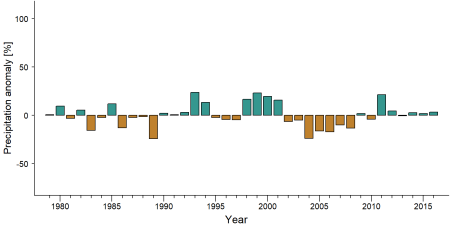
Precipitation anomaly in Messok Dja -
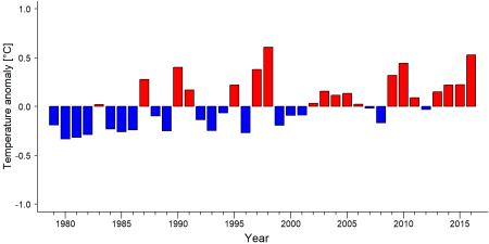
Temperature anomaly in Messok Dja


External links
References
Mantsila, G. M. (2013). Recensement et distribution des grands mammifères de la forêt Messok-Dja (Sembé-Nord Congo). Ministère de l'Economie Forestière et de l'Environnement (Congo); WWF Projet de Conservation Inter-zone.
N’Goran, K. P. (2017). Summary report on WWF biomonitoring activities from 2014 to 2016: Status of forest elephant and great apes in Central Africa priority sites.
WWF. (2018). Decoding conservation: How the lands and ecosystems that wildlife and communities depend upon are protected. Retrieved from https://wwf.panda.org/discover/our_focus/forests_practice/forest_publications_news_and_reports/?339714/Decoding-Conservation-How-the-lands-and-ecosystems-that-wildlife-and-communities-depend-upon-are-protected
WWF. (2019). Republic of Congo: Engaging communities in the future of Messok Dja. Retrieved from https://wwf.panda.org/discover/our_focus/forests_practice/forest_publications_news_and_reports/?356639/Republic-of-Congo-Engaging-communities-in-the-future-of-Messok-Dja
Kiribou, R., Tehoda, P., Chukwu, O., Bempah, G., Kühl, H. S., Ferreira, J., …, & Heinicke, S. (2024). Exposure of African ape sites to climate change impacts. PLOS Climate, 3(2), e0000345. doi:10.1371/journal.pclm.0000345
Page created by: APES Atlas Team Date: 2020-12-06
Page updated by: Diorne Zausa Date: 2024-11-30