
Pic de Fon Classified Forest: Difference between revisions
No edit summary |
No edit summary |
||
| (8 intermediate revisions by the same user not shown) | |||
| Line 14: | Line 14: | ||
* To mitigate negative impacts by proposed mining activities a conservation action plan was written in 2010 but it is unclear which activities were implemented. | * To mitigate negative impacts by proposed mining activities a conservation action plan was written in 2010 but it is unclear which activities were implemented. | ||
* Due to its diverse habitat types Pic de Fon is very rich in biodiversity. | * Due to its diverse habitat types Pic de Fon is very rich in biodiversity. | ||
= Site characteristics = | = Site characteristics = | ||
Pic de Fon Classified Forest is located in southern Guinea at the southern end of the Simandou range and is part of the Greater Nimba Highlands. It has a size of 256 km² and was designated a classified forest in 1953 (UNEP-WCMC & IUCN 2019). The altitude of Pic de Fon ranges from 600 to 1,656 m and is the second highest mountain in Guinea (McCullough 2004). As it lies at the transition between forest and savanna zones it features a diversity of habitats including montane grassland and forest (gallery and ravine forests), semi-evergreen lowland forest (primary and secondary), savanna, rivers, and anthropogenic habitat such as plantations (coffee, cocoa, banana), and farmbush (McCullough 2004). This diversity of habitats leads to a diversity of plant and animal species which were surveyed in a rapid biological assessment in 2002. In this assessment 409 plant, 32 amphibian, 12 reptile, 233 bird, 21 bat, 40 katydid (bush crikets), 17 small mammal, 13 primate and 39 large mammal species were recorded, including species new to science and endemic species (McCullough 2004). Regarding primates the following primate species were recorded: western chimpanzee (''Pan troglodytes verus''), potto (''Perodicticus potto''), Demidoff ’s galago (''Galagoides demidoff''), sooty mangabey (''Cercocebus atys atys''), Campbell’s guenon (''Cercopithecus campbelli campbelli''), lesser spot-nosed guenon (''Cercopithecus petaurista buettikoferi''), greater spot-nosed guenon (''Cercopithecus nicitans''), Diana monkey (''Cercopithecus diana diana'', Herbinger & Tounkara 2004). In a conservation priority setting workshop in 2001, Pic de Fon was identified as having important habitat types for amphibians and reptiles (Bakarr et al. 2001). To inform the extension of the protected area network Brugière and Kormos (2009) identified 16 Key Biodiversity Areas across Guinea based on the occurrence of globally threatened large and medium-sized mammals, among which Pic de Fon Classified Forest ranked eight. | Pic de Fon Classified Forest is located in southern Guinea at the southern end of the Simandou range and is part of the Greater Nimba Highlands. It has a size of 256 km² and was designated a classified forest in 1953 ([[#R01498|UNEP-WCMC & IUCN 2019]]). The altitude of Pic de Fon ranges from 600 to 1,656 m and is the second highest mountain in Guinea ([[#R01495|McCullough 2004]]). As it lies at the transition between forest and savanna zones it features a diversity of habitats including montane grassland and forest (gallery and ravine forests), semi-evergreen lowland forest (primary and secondary), savanna, rivers, and anthropogenic habitat such as plantations (coffee, cocoa, banana), and farmbush ([[#R01495|McCullough 2004]]). This diversity of habitats leads to a diversity of plant and animal species which were surveyed in a rapid biological assessment in 2002. In this assessment 409 plant, 32 amphibian, 12 reptile, 233 bird, 21 bat, 40 katydid (bush crikets), 17 small mammal, 13 primate and 39 large mammal species were recorded, including species new to science and endemic species ([[#R01495|McCullough 2004]]). Regarding primates the following primate species were recorded: western chimpanzee (''Pan troglodytes verus''), potto (''Perodicticus potto''), Demidoff ’s galago (''Galagoides demidoff''), sooty mangabey (''Cercocebus atys atys''), Campbell’s guenon (''Cercopithecus campbelli campbelli''), lesser spot-nosed guenon (''Cercopithecus petaurista buettikoferi''), greater spot-nosed guenon (''Cercopithecus nicitans''), Diana monkey (''Cercopithecus diana diana'', [[#R01493|Herbinger & Tounkara 2004]]). In a conservation priority setting workshop in 2001, Pic de Fon was identified as having important habitat types for amphibians and reptiles ([[#R01487|Bakarr et al. 2001]]). To inform the extension of the protected area network [[#R01489|Brugière and Kormos (2009)]] identified 16 Key Biodiversity Areas across Guinea based on the occurrence of globally threatened large and medium-sized mammals, among which Pic de Fon Classified Forest ranked eight. | ||
Pic de Fon is known to have large iron ore deposits and mining exploration activities began in 1997. While the Guinean government granted a mining concession in 2006, actual mining activities have not yet started and if or when these would go ahead is unclear (Kormos et al. 2014, Rio Tinto 2018). | Pic de Fon is known to have large iron ore deposits and mining exploration activities began in 1997. While the Guinean government granted a mining concession in 2006, actual mining activities have not yet started and if or when these would go ahead is unclear ([[#R02299|Kormos et al. 2014]], [[#R01496|Rio Tinto 2018]]). | ||
'''Table 1. Basic site information for Pic de Fon Classified Forest''' | '''Table 1. Basic site information for Pic de Fon Classified Forest''' | ||
| Line 50: | Line 46: | ||
= Ape status = | = Ape status = | ||
Rebecca Kormos confirmed the presence of chimpanzees in Pic de Fon based on interviews with hunters (Ham 1998). As part of a rapid biological assessment line transect surveys were conducted by Herbinger and Tounkara (2004) and they estimated the size of the chimpanzee population at around 75 weaned individuals. In 2007 a further survey was implemented as part of the Simandou mining project that estimated the chimpanzee population at between 36-46 individuals, but details are not publicly available (Kormos et al. 2014). | Rebecca Kormos confirmed the presence of chimpanzees in Pic de Fon based on interviews with hunters ([[#R01492|Ham 1998]]). As part of a rapid biological assessment line transect surveys were conducted by [[#R01493|Herbinger and Tounkara (2004)]] and they estimated the size of the chimpanzee population at around 75 weaned individuals. In 2007 a further survey was implemented as part of the Simandou mining project that estimated the chimpanzee population at between 36-46 individuals, but details are not publicly available ([[#R02299|Kormos et al. 2014]]). | ||
'''Table 2. Ape population estimates reported for Pic de Fon Classified Forest''' | '''Table 2. Ape population estimates reported for Pic de Fon Classified Forest''' | ||
| Line 68: | Line 64: | ||
|- | |- | ||
|''Pan troglodytes verus'' | |''Pan troglodytes verus'' | ||
| | |2007 | ||
| | | | ||
| | | | ||
| | | | ||
|36-46 | |||
|Pic de Fon | |Pic de Fon | ||
| | |Unknown | ||
| | | | ||
| | |Unknown | ||
| | |Original source unknown, cited in Kormos et al. 2014 | ||
| | | | ||
|- | |- | ||
| Line 89: | Line 85: | ||
|Line transects | |Line transects | ||
| | | | ||
|Herbinger & Tounkara 2004 | |[[#R01493|Herbinger & Tounkara 2004]] | ||
|Total survey effort: 17.2 km | |Total survey effort: 17.2 km | ||
| | | | ||
|- | |- | ||
|''Pan troglodytes verus'' | |''Pan troglodytes verus'' | ||
| | |1997 | ||
|Present | |||
| | | | ||
| | | | ||
| | | | ||
|Pic de Fon | |Pic de Fon | ||
| | |Interviews | ||
| | | | ||
|[[#R01492|Ham 1998]] | |||
|Interview of hunters | |||
|GIN0019, GIN0021 | |||
|} | |} | ||
| Line 111: | Line 107: | ||
= Threats = | = Threats = | ||
A rapid biological assessment in 2002 identified 24 villages in the vicinity of Pic de Fon Classified Forest and concluded that villagers rely strongly on the forest as a source of food (e.g., wildlife, fish, fruits), water, wood for fuel and construction, and medicinal plants (McCullough 2004). Hunting was identified as the biggest threat to chimpanzees and wildlife in general (McCullough 2004). Hunting camps were also found inside the classified forest. 35-40% of the forest are impacted by the cultivation of subsistence and cash crops, including coffee (McCullough 2004). Fires are set intentionally to clear land for agriculture. | A rapid biological assessment in 2002 identified 24 villages in the vicinity of Pic de Fon Classified Forest and concluded that villagers rely strongly on the forest as a source of food (e.g., wildlife, fish, fruits), water, wood for fuel and construction, and medicinal plants ([[#R01495|McCullough 2004]]). Hunting was identified as the biggest threat to chimpanzees and wildlife in general ([[#R01495|McCullough 2004]]). Hunting camps were also found inside the classified forest. 35-40% of the forest are impacted by the cultivation of subsistence and cash crops, including coffee ([[#R01495|McCullough 2004]]). Fires are set intentionally to clear land for agriculture. | ||
A further concern to chimpanzees is the “Simandou Project”, an iron-ore mining concession held by Rio Tinto and Chinalco (Aluminium Corporation of China, Kormos et al. 2014). Exploration for mining of the iron ore started in 1997 and the mining concession was granted in 2006 by the Guinean government. Mining exploration can cause noise pollution and the presence of more people in the forest further disturbs chimpanzees (Herbinger & Tounkara 2004). Roads were build as part of the mining exploration, indirectly affecting chimpanzees by increasing accessibility by humans and possibly hunting pressure. Part of the concession area overlaps with the forest of Pic de Fon (Konate pers. comm. 2023). | A further concern to chimpanzees is the “Simandou Project”, an iron-ore mining concession held by Rio Tinto and Chinalco (Aluminium Corporation of China, [[#R02299|Kormos et al. 2014]]). Exploration for mining of the iron ore started in 1997 and the mining concession was granted in 2006 by the Guinean government. Mining exploration can cause noise pollution and the presence of more people in the forest further disturbs chimpanzees ([[#R01493|Herbinger & Tounkara 2004]]). Roads were build as part of the mining exploration, indirectly affecting chimpanzees by increasing accessibility by humans and possibly hunting pressure. Part of the concession area overlaps with the forest of Pic de Fon (Konate pers. comm. 2023). | ||
The 2002 survey of Pic de Fon found hunting pressure and agricultural activities to be most prevalent in lower altitudes and no chimpanzee nests were found below 900 m altitude. As mining activities will be in higher altitudes this would likely strongly impact chimpanzees in their core habitat (Herbinger & Tounkara 2004). | The 2002 survey of Pic de Fon found hunting pressure and agricultural activities to be most prevalent in lower altitudes and no chimpanzee nests were found below 900 m altitude. As mining activities will be in higher altitudes this would likely strongly impact chimpanzees in their core habitat ([[#R01493|Herbinger & Tounkara 2004]]). | ||
In connection with the mining project concerns have also been raised in relation to social issues, environmental damage by pollution and changes in the hydrology, and corruption (Environmental Justice Atlas 2019, Boyes 2014 ). | In connection with the mining project concerns have also been raised in relation to social issues, environmental damage by pollution and changes in the hydrology, and corruption ([[#R01491|Environmental Justice Atlas 2019]], [[#R01488|Boyes 2014]] ). | ||
'''Table 3. Threats to apes reported for Pic de Fon Classified Forest''' | '''Table 3. Threats to apes reported for Pic de Fon Classified Forest''' | ||
| Line 126: | Line 122: | ||
!Description | !Description | ||
!Year of threat | !Year of threat | ||
|- | |||
|2 Agriculture & aquaculture | |||
|2.1 Annual & perennial non-timber crops | |||
|High (more than 70% of population affected) | |||
|35-40% of the forest are impacted by agricultural activities ([[#R01495|McCullough 2004]]). | |||
|Ongoing (2004) | |||
|- | |||
|2 Agriculture & aquaculture | |||
|2.3 Livestock farming & ranching | |||
|High (more than 70% of population affected) | |||
|Cattle herding (Konate pers. Comm. 2023). | |||
|Ongoing (2023) | |||
|- | |- | ||
|3 Energy production & mining | |3 Energy production & mining | ||
|3.2 Mining & quarrying | |3.2 Mining & quarrying | ||
|Medium (30-70% of population affected) | |Medium (30-70% of population affected) | ||
|Exploration for mining since 1997 (Herbinger and Tounkara 2004). Rio Tinto concession area overlaps with the site, and artisanal mining ongoing (Konate pers. Comm. 2023). | |Exploration for mining since 1997 ([[#R01493|Herbinger and Tounkara 2004]]). Rio Tinto concession area overlaps with the site, and artisanal mining ongoing (Konate pers. Comm. 2023). | ||
|1997-Ongoing (2023) | |1997-Ongoing (2023) | ||
|- | |||
|4 Transportation & service corridors | |||
|4.1 Roads & railroads | |||
|Medium (30-70% of population affected) | |||
|Roads build for mining exploration ([[#R01493|Herbinger and Tounkara 2004]]). | |||
|Ongoing (2004) | |||
|- | |- | ||
|5 Biological resource use | |5 Biological resource use | ||
|5.1 Hunting & collecting terrestrial animals | |5.1 Hunting & collecting terrestrial animals | ||
|High (more than 70% of population affected) | |High (more than 70% of population affected) | ||
|Identified as the most prevalent threat (Herbinger and Tounkara 2004). Hunting is ongoing (Konate pers. Comm. 2023). | |Identified as the most prevalent threat ([[#R01493|Herbinger and Tounkara 2004]]). Hunting is ongoing (Konate pers. Comm. 2023). | ||
|2004-Ongoing (2023) | |2004-Ongoing (2023) | ||
|- | |- | ||
|5 Biological resource use | |5 Biological resource use | ||
|5.2 Gathering terrestrial plants | |5.2 Gathering terrestrial plants | ||
|Medium (30-70% of population affected) | |Medium (30-70% of population affected) | ||
|Collection of fruits and medicinal plants (McCullough 2004). | |Collection of fruits and medicinal plants ([[#R01495|McCullough 2004]]). | ||
|Ongoing (2004) | |Ongoing (2004) | ||
|- | |- | ||
| Line 160: | Line 162: | ||
|5.3 Logging & wood harvesting | |5.3 Logging & wood harvesting | ||
|Medium (30-70% of population affected) | |Medium (30-70% of population affected) | ||
|Wood collected for fuel and construction (McCullough 2004). | |Wood collected for fuel and construction ([[#R01495|McCullough 2004]]). | ||
|Ongoing (2004) | |Ongoing (2004) | ||
|- | |- | ||
| Line 166: | Line 168: | ||
|7.1 Fire & fire suppression | |7.1 Fire & fire suppression | ||
|Medium (30-70% of population affected) | |Medium (30-70% of population affected) | ||
|Fire are set for clearing areas for agricultural use (McCullough 2004). | |Fire are set for clearing areas for agricultural use ([[#R01495|McCullough 2004]]). | ||
|Ongoing (2004) | |Ongoing (2004) | ||
|- | |- | ||
| Line 172: | Line 174: | ||
|9.6 Energy emissions | |9.6 Energy emissions | ||
|Present (unknown severity) | |Present (unknown severity) | ||
|Noise pollution during mining exploration (Herbinger and Tounkara 2004). | |Noise pollution during mining exploration ([[#R01493|Herbinger and Tounkara 2004]]). | ||
|Ongoing (2004) | |Ongoing (2004) | ||
|} | |} | ||
| Line 186: | Line 182: | ||
= Conservation activities = | = Conservation activities = | ||
One outcome of the rapid biological assessment conducted as part of an alliance between Conservation International and Rio Tinto Mining & Exploration in 2002, was an initial biodiversity action plan for Pic de Fon Classified Forest (McCullough 2004). The conservation objectives set out in this plan focus on biodiversity data and monitoring, regulating resource-use, awareness and capacity building, and strengthening the legal protection of the forest (McCullough 2004). However, it is not clear whether any of these activities have been implemented. | One outcome of the rapid biological assessment conducted as part of an alliance between Conservation International and Rio Tinto Mining & Exploration in 2002, was an initial biodiversity action plan for Pic de Fon Classified Forest ([[#R01495|McCullough 2004]]). The conservation objectives set out in this plan focus on biodiversity data and monitoring, regulating resource-use, awareness and capacity building, and strengthening the legal protection of the forest ([[#R01495|McCullough 2004]]). However, it is not clear whether any of these activities have been implemented. | ||
To mitigate negative impacts by the development of the iron ore mine a community-based management plan was developed as part of a collaboration between the Guinean government, Rio Tinto and local communities in 2010 (TBC 2019). As part of the conservation action plan Pic de Fon was divided into three zones: a protected area, a production area that can be used by local communities and the mining area (Diakite et al. 2010). Different activities were planned, including regulating hunting and usage of non-timber forest products, control of bushfires, reforestation (TBC 2019). However, as the development of the mine is not progressing and Rio Tinto is trying to sell its share, it is not clear if any of these activities have actually been implemented. | To mitigate negative impacts by the development of the iron ore mine a community-based management plan was developed as part of a collaboration between the Guinean government, Rio Tinto and local communities in 2010 ([[#R01497|TBC 2019]]). As part of the conservation action plan Pic de Fon was divided into three zones: a protected area, a production area that can be used by local communities and the mining area ([[#R01490|Diakite et al. 2010]]). Different activities were planned, including regulating hunting and usage of non-timber forest products, control of bushfires, reforestation ([[#R01497|TBC 2019]]). However, as the development of the mine is not progressing and Rio Tinto is trying to sell its share, it is not clear if any of these activities have actually been implemented. | ||
'''Table 4. Conservation activities reported for Pic de Fon Classified Forest''' | '''Table 4. Conservation activities reported for Pic de Fon Classified Forest''' | ||
| Line 200: | Line 196: | ||
|1 Development impact mitigation | |1 Development impact mitigation | ||
|1.8 Use set-aside areas of natural habitat (e.g., mining, logging, agricultural areas) | |1.8 Use set-aside areas of natural habitat (e.g., mining, logging, agricultural areas) | ||
|Conservation action plan specifies a zone that should be fully protected (Diakite et al. 2010) | |Conservation action plan specifies a zone that should be fully protected ([[#R01490|Diakite et al. 2010]]) | ||
| | | | ||
|2010 | |2010 | ||
| Line 206: | Line 202: | ||
|5 Protection & restoration | |5 Protection & restoration | ||
|5.2 Legally protect ape habitat | |5.2 Legally protect ape habitat | ||
|Designated as Classified Forest in 1953 (UNEP-WCMC and IUCN 2019) | |Designated as Classified Forest in 1953 ([[#R01498|UNEP-WCMC and IUCN 2019]]) | ||
| | | | ||
|Ongoing (2023) | |1953-Ongoing (2023) | ||
|- | |- | ||
|5 Protection & restoration | |5 Protection & restoration | ||
| Line 221: | Line 217: | ||
= Challenges = | = Challenges = | ||
The lack of capacity among regional actors, including government agencies, local communities and NGOs has been noted as an impediment, for example to implement law enforcement (McCullough 2004). Civil unrest, and conflict on land tenure were also mentioned as conservation impediments (McCullough 2004). | The lack of capacity among regional actors, including government agencies, local communities and NGOs has been noted as an impediment, for example to implement law enforcement ([[#R01495|McCullough 2004]]). Civil unrest, and conflict on land tenure were also mentioned as conservation impediments ([[#R01495|McCullough 2004]]). | ||
'''Table 5. Challenges reported for Pic de Fon Classified Forest''' | '''Table 5. Challenges reported for Pic de Fon Classified Forest''' | ||
| Line 229: | Line 225: | ||
!Source | !Source | ||
!Year(s) | !Year(s) | ||
|- | |||
|1 Site management | |||
|1.4 Conflict on land tenure | |||
|[[#R01495|McCullough 2004]] | |||
| | |||
|- | |- | ||
|2 Resources and capacity | |2 Resources and capacity | ||
|2.1 Lack of capacity/training | |2.1 Lack of capacity/training | ||
|McCullough 2004 | |[[#R01495|McCullough 2004]] | ||
| | | | ||
|- | |- | ||
|6 Safety and stability | |6 Safety and stability | ||
|6.3 Civil unrest/war | |6.3 Civil unrest/war | ||
| | |[[#R01495|McCullough 2004]] | ||
|McCullough 2004 | |||
| | | | ||
|} | |} | ||
| Line 294: | Line 290: | ||
= Research activities = | = Research activities = | ||
As detailed above surveys on chimpanzees have been implemented (Ham 1998, Herbinger & Tounkara 2004, Kormos et al. 2014). | As detailed above surveys on chimpanzees have been implemented ([[#R01492|Ham 1998]], [[#R01493|Herbinger & Tounkara 2004]], [[#R02299|Kormos et al. 2014]]). | ||
| Line 328: | Line 324: | ||
= Exposure to climate change impacts = | = Exposure to climate change impacts = | ||
As part of a study on the exposure of African great ape sites to climate change impacts, Kiribou et al. | As part of a study on the exposure of African great ape sites to climate change impacts, [[#R02300|Kiribou et al. (2024)]] extracted climate data and data on projected extreme climate impact events for the site. Climatological characteristics were derived from observation-based climate data provided by the Inter-Sectoral Impact Model Intercomparison Project (ISIMIP, www.isimip.org). Parameters were calculated as the average across each 30-year period. For 1981-2010, the EWEMBI dataset from ISIMIP2a was used. For the two future periods (2021-2050 and 2071-2099) ISIMIP2b climate data based on four CMIP5 global climate models were used. For future projections, two Representative Concentration Pathways (RCP) were used. RCP 2.6 is a scenario with strong mitigation measures in which global temperatures would likely rise below 2C. RCP 6.0 is a scenario with medium emissions in which global temperatures would likely rise up to 3C by 2100. For the number of days with heavy precipitation events, the 98th percentile of all precipitation days (>1mm/d) was calculated for the 1979-2013 reference period as a threshold for a heavy precipitation event. Then, for each year, the number of days above that threshold was derived. The figures on temperature and precipitation anomaly show the deviation from the mean temperature and mean precipitation for the 1979-2013 reference period. | ||
The estimated exposure to future extreme climate impact events (crop failure, drought, river flood, wildfire, tropical cyclone, and heatwave) is based on a published dataset by Lange et al. 2020 derived from ISIMIP2b data. The same global climate models and RCPs as described above were used. Within each 30-year period, the number of years with an extreme event and the average proportion of the site affected were calculated ( | The estimated exposure to future extreme climate impact events (crop failure, drought, river flood, wildfire, tropical cyclone, and heatwave) is based on a published dataset by Lange et al. 2020 derived from ISIMIP2b data. The same global climate models and RCPs as described above were used. Within each 30-year period, the number of years with an extreme event and the average proportion of the site affected were calculated ([[#R02300|Kiribou et al. 2024]]). | ||
'''Table 8. Estimated past and projected climatological characteristics in Pic de Fon Classified Forest''' | '''Table 8. Estimated past and projected climatological characteristics in Pic de Fon Classified Forest''' | ||
| Line 453: | Line 449: | ||
= References = | = References = | ||
Bakarr M et al. 2001. in IUCN 2008. From forest to the sea: biodiversity connections from Guinea to Togo. Conservation priority setting workshop. Washington D.C., USA: Conservation International | <span id="R01487"></span>Bakarr M et al. 2001. in IUCN 2008. From forest to the sea: biodiversity connections from Guinea to Togo. Conservation priority setting workshop. Washington D.C., USA: Conservation International | ||
<span id="R01488"></span>Boyes S. 2014. Rio Tinto Simandou: Exporting Iron Mountains. National Geographic. 27 January 2014. [https://blog.nationalgeographic.org/2014/01/27/rio-tinto-simandou-exporting-iron-mountains-part-1-of-2/ blog.nationalgeographic.org] | |||
<span id="R01489"></span>Brugière D, Kormos R. 2009. Review of the protected area network in Guinea, West Africa, and recommendations for new sites for biodiversity conservation, Biodiversity and Conservation, 18:847 [https://doi.org/10.1007/s10531-008-9508-z doi:10.1007/s10531-008-9508-z] | |||
<span id="R01490"></span>Diakite et al. 2010. Plan d’aménagement et plan de gestion de la Forêt Classée du Pic de Fon 2010- 2030. [http://www.thebiodiversityconsultancy.com/es/wp-content/uploads/2013/08/Plan-dAmenagement-de-la-Foret-Classee-du-Pic-de-Fon_Version-Approuvee_ResolutionDiminuee-1.pdf www.thebiodiversityconsultancy.com] | |||
<span id="R01491"></span>Environmental Justice Atlas. 2019. Iron Mine on Simandou Mountain Range, Mine de Fer, Guinée, [https://ejatlas.org/conflict/simandoun-mine ejatlas.org] | |||
<span id="R01492"></span>Ham R. 1998. Nationwide chimpanzee census and large mammal survey Republic of Guinea. Projet de conservation des chimpanzés en Guineée. Report to the European Union. | |||
<span id="R01493"></span>Herbinger I, Tounkara EO. 2004. A rapid survey of primates in the Simandou Range, Pic de Fon, Guinea, in McCullough (ed) A Rapid Biological Assessment of the Forêt Classée du Pic de Fon, Simandou Range, Southeastern Republic of Guinea. RAP Bulletin of Biological Assessment 35. Conservation International, Washington, DC. | |||
<span id="R01494"></span>Kormos R et al. 2004. Great apes and biodiversity offset projects in Africa: the case for national offset strategies. Plos One 9(11): e111671, doi:10.1371/journal.pone.0111671 | |||
<span id="R01495"></span>McCullough J. 2004. A Rapid Biological Assessment of the Forêt Classée du Pic de Fon, Simandou Range, Southeastern Republic of Guinea. RAP Bulletin of Biological Assessment 35. Conservation International, Washington, DC. | |||
<span id="R01496"></span>Rio Tinto. 2018. Rio Tinto update on Simandou. [https://www.riotinto.com/documents/181029_Rio_Tinto_update_on_Simandou.pdf Press release from 29 October 2018] | |||
<span id="R01497"></span>TBC. 2019. Rio Tinto Simandou, Guinea: Pic de Fon Forêt Classée [https://www.thebiodiversityconsultancy.com/map/simandou-2/ www.thebiodiversityconsultancy.com] | |||
<span id="R01498"></span>UNEP-WCMC, IUCN. 2019. Protected Planet: The World Database on Protected Areas (WDPA), Cambridge, UK: UNEP-WCMC and IUCN Online: [https://www.protectedplanet.net/29465 www.protectedplanet.net] [https://web.archive.org/web/20190919232508/https://www.protectedplanet.net/lagoas-de-cufada-natural-park link] | |||
<span id="R02299"></span>Kormos, R., Kormos, C. F., Humle, T., Lanjouw, A., Rainer, H., Victurine, R., …, & Williamson, E. A. (2014). Great Apes and Biodiversity Offset Projects in Africa: The Case for National Offset Strategies. ''PLoS ONE'', 9(11), 1-14. [https://doi.org/10.1371/journal.pone.0111671 doi:10.1371/journal.pone.0111671] | |||
<span id="R02300"></span>Kiribou, R., Tehoda, P., Chukwu, O., Bempah, G., Kühl, H. S., Ferreira, J., …, & Heinicke, S. (2024). Exposure of African ape sites to climate change impacts. ''PLOS Climate'', 3(2), e0000345. [https://doi.org/10.1371/journal.pclm.0000345 doi:10.1371/journal.pclm.0000345] | |||
'''Page created by: '''APES Atlas Team''' Date:''' 2023-10-02 | '''Page created by: '''APES Atlas Team''' Date:''' 2023-10-02 | ||
Latest revision as of 17:54, 15 October 2026
West Africa > Republic of Guinea > Pic de Fon Classified Forest
Français | Português | Español | Bahasa Indonesia | Melayu
Summary
- Western chimpanzees (Pan troglodytes verus) are present in Pic de Fon Classified Forest.
- It has been estimated that 75 (CI: 21-246) individuals occur in the forest.
- The chimpanzee population trend is unknown.
- This site has a total size of 256 km².
- Key threats to chimpanzees are hunting and habitat degradation due to agricultural activities and fires, as well as exploration for mining.
- To mitigate negative impacts by proposed mining activities a conservation action plan was written in 2010 but it is unclear which activities were implemented.
- Due to its diverse habitat types Pic de Fon is very rich in biodiversity.
Site characteristics
Pic de Fon Classified Forest is located in southern Guinea at the southern end of the Simandou range and is part of the Greater Nimba Highlands. It has a size of 256 km² and was designated a classified forest in 1953 (UNEP-WCMC & IUCN 2019). The altitude of Pic de Fon ranges from 600 to 1,656 m and is the second highest mountain in Guinea (McCullough 2004). As it lies at the transition between forest and savanna zones it features a diversity of habitats including montane grassland and forest (gallery and ravine forests), semi-evergreen lowland forest (primary and secondary), savanna, rivers, and anthropogenic habitat such as plantations (coffee, cocoa, banana), and farmbush (McCullough 2004). This diversity of habitats leads to a diversity of plant and animal species which were surveyed in a rapid biological assessment in 2002. In this assessment 409 plant, 32 amphibian, 12 reptile, 233 bird, 21 bat, 40 katydid (bush crikets), 17 small mammal, 13 primate and 39 large mammal species were recorded, including species new to science and endemic species (McCullough 2004). Regarding primates the following primate species were recorded: western chimpanzee (Pan troglodytes verus), potto (Perodicticus potto), Demidoff ’s galago (Galagoides demidoff), sooty mangabey (Cercocebus atys atys), Campbell’s guenon (Cercopithecus campbelli campbelli), lesser spot-nosed guenon (Cercopithecus petaurista buettikoferi), greater spot-nosed guenon (Cercopithecus nicitans), Diana monkey (Cercopithecus diana diana, Herbinger & Tounkara 2004). In a conservation priority setting workshop in 2001, Pic de Fon was identified as having important habitat types for amphibians and reptiles (Bakarr et al. 2001). To inform the extension of the protected area network Brugière and Kormos (2009) identified 16 Key Biodiversity Areas across Guinea based on the occurrence of globally threatened large and medium-sized mammals, among which Pic de Fon Classified Forest ranked eight.
Pic de Fon is known to have large iron ore deposits and mining exploration activities began in 1997. While the Guinean government granted a mining concession in 2006, actual mining activities have not yet started and if or when these would go ahead is unclear (Kormos et al. 2014, Rio Tinto 2018).
Table 1. Basic site information for Pic de Fon Classified Forest
| Species | Pan troglodytes verus |
| Area | 256 km² |
| Coordinates | Lat: 8.55 , Lon: -8.88 |
| Type of site | Protected area (Classified Forest) |
| Habitat types | Subtropical/tropical moist montane forest, Subtropical/tropical moist lowland forest, Grassland, Savanna, Wetlands (lakes, rivers, streams, bogs, marshes), Agricultural land |
| Type of governance |
Types of sites Governance types Habitat types
Ape status
Rebecca Kormos confirmed the presence of chimpanzees in Pic de Fon based on interviews with hunters (Ham 1998). As part of a rapid biological assessment line transect surveys were conducted by Herbinger and Tounkara (2004) and they estimated the size of the chimpanzee population at around 75 weaned individuals. In 2007 a further survey was implemented as part of the Simandou mining project that estimated the chimpanzee population at between 36-46 individuals, but details are not publicly available (Kormos et al. 2014).
Table 2. Ape population estimates reported for Pic de Fon Classified Forest
| Species | Year | Occurrence | Encounter or vistation rate (nests/km; ind/day) | Density estimate [ind./ km²] (95% CI) | Abundance estimate (95% CI) | Survey area | Sampling method | Analytical framework | Source | Comments | A.P.E.S. database ID |
|---|---|---|---|---|---|---|---|---|---|---|---|
| Pan troglodytes verus | 2007 | 36-46 | Pic de Fon | Unknown | Unknown | Original source unknown, cited in Kormos et al. 2014 | |||||
| Pan troglodytes verus | 2002 | 6.80 | 0.64 | 75 (21-246) | Pic de Fon | Line transects | Herbinger & Tounkara 2004 | Total survey effort: 17.2 km | |||
| Pan troglodytes verus | 1997 | Present | Pic de Fon | Interviews | Ham 1998 | Interview of hunters | GIN0019, GIN0021 |
Sampling methods Analytical frameworks
Threats
A rapid biological assessment in 2002 identified 24 villages in the vicinity of Pic de Fon Classified Forest and concluded that villagers rely strongly on the forest as a source of food (e.g., wildlife, fish, fruits), water, wood for fuel and construction, and medicinal plants (McCullough 2004). Hunting was identified as the biggest threat to chimpanzees and wildlife in general (McCullough 2004). Hunting camps were also found inside the classified forest. 35-40% of the forest are impacted by the cultivation of subsistence and cash crops, including coffee (McCullough 2004). Fires are set intentionally to clear land for agriculture.
A further concern to chimpanzees is the “Simandou Project”, an iron-ore mining concession held by Rio Tinto and Chinalco (Aluminium Corporation of China, Kormos et al. 2014). Exploration for mining of the iron ore started in 1997 and the mining concession was granted in 2006 by the Guinean government. Mining exploration can cause noise pollution and the presence of more people in the forest further disturbs chimpanzees (Herbinger & Tounkara 2004). Roads were build as part of the mining exploration, indirectly affecting chimpanzees by increasing accessibility by humans and possibly hunting pressure. Part of the concession area overlaps with the forest of Pic de Fon (Konate pers. comm. 2023).
The 2002 survey of Pic de Fon found hunting pressure and agricultural activities to be most prevalent in lower altitudes and no chimpanzee nests were found below 900 m altitude. As mining activities will be in higher altitudes this would likely strongly impact chimpanzees in their core habitat (Herbinger & Tounkara 2004).
In connection with the mining project concerns have also been raised in relation to social issues, environmental damage by pollution and changes in the hydrology, and corruption (Environmental Justice Atlas 2019, Boyes 2014 ).
Table 3. Threats to apes reported for Pic de Fon Classified Forest
| Category | Specific threats | Threat level | Description | Year of threat |
|---|---|---|---|---|
| 2 Agriculture & aquaculture | 2.1 Annual & perennial non-timber crops | High (more than 70% of population affected) | 35-40% of the forest are impacted by agricultural activities (McCullough 2004). | Ongoing (2004) |
| 2 Agriculture & aquaculture | 2.3 Livestock farming & ranching | High (more than 70% of population affected) | Cattle herding (Konate pers. Comm. 2023). | Ongoing (2023) |
| 3 Energy production & mining | 3.2 Mining & quarrying | Medium (30-70% of population affected) | Exploration for mining since 1997 (Herbinger and Tounkara 2004). Rio Tinto concession area overlaps with the site, and artisanal mining ongoing (Konate pers. Comm. 2023). | 1997-Ongoing (2023) |
| 4 Transportation & service corridors | 4.1 Roads & railroads | Medium (30-70% of population affected) | Roads build for mining exploration (Herbinger and Tounkara 2004). | Ongoing (2004) |
| 5 Biological resource use | 5.1 Hunting & collecting terrestrial animals | High (more than 70% of population affected) | Identified as the most prevalent threat (Herbinger and Tounkara 2004). Hunting is ongoing (Konate pers. Comm. 2023). | 2004-Ongoing (2023) |
| 5 Biological resource use | 5.2 Gathering terrestrial plants | Medium (30-70% of population affected) | Collection of fruits and medicinal plants (McCullough 2004). | Ongoing (2004) |
| 5 Biological resource use | 5.3 Logging & wood harvesting | Medium (30-70% of population affected) | Wood collected for fuel and construction (McCullough 2004). | Ongoing (2004) |
| 7 Natural system modifications | 7.1 Fire & fire suppression | Medium (30-70% of population affected) | Fire are set for clearing areas for agricultural use (McCullough 2004). | Ongoing (2004) |
| 9 Pollution | 9.6 Energy emissions | Present (unknown severity) | Noise pollution during mining exploration (Herbinger and Tounkara 2004). | Ongoing (2004) |
Conservation activities
One outcome of the rapid biological assessment conducted as part of an alliance between Conservation International and Rio Tinto Mining & Exploration in 2002, was an initial biodiversity action plan for Pic de Fon Classified Forest (McCullough 2004). The conservation objectives set out in this plan focus on biodiversity data and monitoring, regulating resource-use, awareness and capacity building, and strengthening the legal protection of the forest (McCullough 2004). However, it is not clear whether any of these activities have been implemented.
To mitigate negative impacts by the development of the iron ore mine a community-based management plan was developed as part of a collaboration between the Guinean government, Rio Tinto and local communities in 2010 (TBC 2019). As part of the conservation action plan Pic de Fon was divided into three zones: a protected area, a production area that can be used by local communities and the mining area (Diakite et al. 2010). Different activities were planned, including regulating hunting and usage of non-timber forest products, control of bushfires, reforestation (TBC 2019). However, as the development of the mine is not progressing and Rio Tinto is trying to sell its share, it is not clear if any of these activities have actually been implemented.
Table 4. Conservation activities reported for Pic de Fon Classified Forest
| Category | Specific activity | Description | Implementing organization(s) | Year of activity |
|---|---|---|---|---|
| 1 Development impact mitigation | 1.8 Use set-aside areas of natural habitat (e.g., mining, logging, agricultural areas) | Conservation action plan specifies a zone that should be fully protected (Diakite et al. 2010) | 2010 | |
| 5 Protection & restoration | 5.2 Legally protect ape habitat | Designated as Classified Forest in 1953 (UNEP-WCMC and IUCN 2019) | 1953-Ongoing (2023) | |
| 5 Protection & restoration | 5.6 Habitat restoration | Planting of trees to create a corridor between Pic de Fon and another forest (Konate pers. Comm. 2023). | Ongoing (2023) |
Challenges
The lack of capacity among regional actors, including government agencies, local communities and NGOs has been noted as an impediment, for example to implement law enforcement (McCullough 2004). Civil unrest, and conflict on land tenure were also mentioned as conservation impediments (McCullough 2004).
Table 5. Challenges reported for Pic de Fon Classified Forest
| Challenges | Specific challenges | Source | Year(s) |
|---|---|---|---|
| 1 Site management | 1.4 Conflict on land tenure | McCullough 2004 | |
| 2 Resources and capacity | 2.1 Lack of capacity/training | McCullough 2004 | |
| 6 Safety and stability | 6.3 Civil unrest/war | McCullough 2004 |
Enablers
Table 6. Enablers reported for Pic de Fon Classified Forest
| Enablers | Specific enablers | Source | Year(s) |
|---|---|---|---|
| 1 Site management | |||
| 2 Resources and capacity | |||
| 3 Engaged community | |||
| 4 Institutional support | |||
| 5 Ecological context | |||
| 6 Safety and stability |
Research activities
As detailed above surveys on chimpanzees have been implemented (Ham 1998, Herbinger & Tounkara 2004, Kormos et al. 2014).
Documented behaviours
Table 7. Behaviours documented for Pic de Fon Classified Forest
| Category | Behavior | Observation type | Prevalence | Observation dates | Source | Habituation | Species | Comment |
|---|---|---|---|---|---|---|---|---|
| Not reported |
Exposure to climate change impacts
As part of a study on the exposure of African great ape sites to climate change impacts, Kiribou et al. (2024) extracted climate data and data on projected extreme climate impact events for the site. Climatological characteristics were derived from observation-based climate data provided by the Inter-Sectoral Impact Model Intercomparison Project (ISIMIP, www.isimip.org). Parameters were calculated as the average across each 30-year period. For 1981-2010, the EWEMBI dataset from ISIMIP2a was used. For the two future periods (2021-2050 and 2071-2099) ISIMIP2b climate data based on four CMIP5 global climate models were used. For future projections, two Representative Concentration Pathways (RCP) were used. RCP 2.6 is a scenario with strong mitigation measures in which global temperatures would likely rise below 2C. RCP 6.0 is a scenario with medium emissions in which global temperatures would likely rise up to 3C by 2100. For the number of days with heavy precipitation events, the 98th percentile of all precipitation days (>1mm/d) was calculated for the 1979-2013 reference period as a threshold for a heavy precipitation event. Then, for each year, the number of days above that threshold was derived. The figures on temperature and precipitation anomaly show the deviation from the mean temperature and mean precipitation for the 1979-2013 reference period.
The estimated exposure to future extreme climate impact events (crop failure, drought, river flood, wildfire, tropical cyclone, and heatwave) is based on a published dataset by Lange et al. 2020 derived from ISIMIP2b data. The same global climate models and RCPs as described above were used. Within each 30-year period, the number of years with an extreme event and the average proportion of the site affected were calculated (Kiribou et al. 2024).
Table 8. Estimated past and projected climatological characteristics in Pic de Fon Classified Forest
| Value | 1981-2010 | 2021-2050, RCP 2.6 | 2021-2050, RCP 6.0 | 2071-2099, RCP 2.6 | 2071-2099, RCP 6.0 |
|---|---|---|---|---|---|
| Mean temperature [C] | 24 | 25.3 | 25.1 | 25.3 | 26.5 |
| Annual precipitation [mm] | 1802 | 1817 | 1845 | 1868 | 1936 |
| Max no. consecutive dry days (per year) | 40.5 | 42 | 44 | 43.6 | 47 |
| No. days with heavy precipitation (per year) | 5.5 | 9.2 | 8.5 | 9.9 | 10.8 |
Table 9. Projected exposure of apes to extreme climate impact events in Pic de Fon Classified Forest
| Type | No. of years with event (2021-2050, RCP 2.6) | % of site exposed (2021-2050, RCP 2.6) | No. of years with event (2021-2050, RCP 6.0) | % of site exposed (2021-2050, RCP 6.0) | No. of years with event (2070-2099, RCP 2.6) | % of site exposed (2070-2099, RCP 2.6) | No. of years with event (2070-2099, RCP 6.0) | % of site exposed (2070-2099, RCP 6.0) |
|---|---|---|---|---|---|---|---|---|
| Crop failure | 6.5 | 0.19 | 3.5 | 0.19 | 6 | 0.19 | 14.5 | 0.19 |
| Drought | 0 | 0 | 0 | 0 | 0 | 0 | 0 | 0 |
| Heatwave | 6 | 100 | 6.5 | 100 | 6 | 100 | 7.5 | 100 |
| River flood | 1 | 0.09 | 1 | 1.11 | 1.5 | 1.07 | 3.5 | 0.71 |
| Tropical cyclone | 0 | 0 | 0 | 0 | 0 | 0 | 0 | 0 |
| Wildfire | 30 | 0.9 | 30 | 0.97 | 29 | 0.96 | 29 | 0.94 |
-
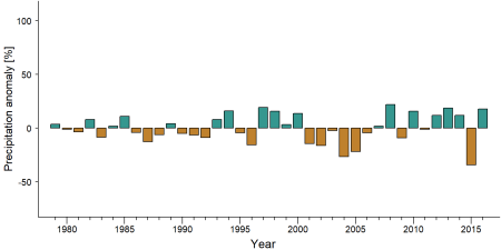
Precipitation anomaly in Pic de Fon Classified Forest -
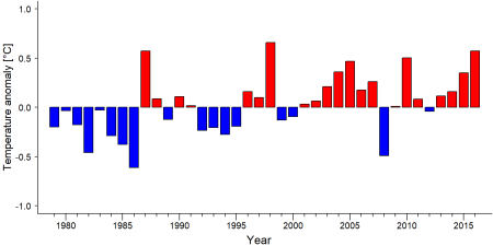
Temperature anomaly in Pic de Fon Classified Forest


External links
References
Bakarr M et al. 2001. in IUCN 2008. From forest to the sea: biodiversity connections from Guinea to Togo. Conservation priority setting workshop. Washington D.C., USA: Conservation International
Boyes S. 2014. Rio Tinto Simandou: Exporting Iron Mountains. National Geographic. 27 January 2014. blog.nationalgeographic.org
Brugière D, Kormos R. 2009. Review of the protected area network in Guinea, West Africa, and recommendations for new sites for biodiversity conservation, Biodiversity and Conservation, 18:847 doi:10.1007/s10531-008-9508-z
Diakite et al. 2010. Plan d’aménagement et plan de gestion de la Forêt Classée du Pic de Fon 2010- 2030. www.thebiodiversityconsultancy.com
Environmental Justice Atlas. 2019. Iron Mine on Simandou Mountain Range, Mine de Fer, Guinée, ejatlas.org
Ham R. 1998. Nationwide chimpanzee census and large mammal survey Republic of Guinea. Projet de conservation des chimpanzés en Guineée. Report to the European Union.
Herbinger I, Tounkara EO. 2004. A rapid survey of primates in the Simandou Range, Pic de Fon, Guinea, in McCullough (ed) A Rapid Biological Assessment of the Forêt Classée du Pic de Fon, Simandou Range, Southeastern Republic of Guinea. RAP Bulletin of Biological Assessment 35. Conservation International, Washington, DC.
Kormos R et al. 2004. Great apes and biodiversity offset projects in Africa: the case for national offset strategies. Plos One 9(11): e111671, doi:10.1371/journal.pone.0111671
McCullough J. 2004. A Rapid Biological Assessment of the Forêt Classée du Pic de Fon, Simandou Range, Southeastern Republic of Guinea. RAP Bulletin of Biological Assessment 35. Conservation International, Washington, DC.
Rio Tinto. 2018. Rio Tinto update on Simandou. Press release from 29 October 2018
TBC. 2019. Rio Tinto Simandou, Guinea: Pic de Fon Forêt Classée www.thebiodiversityconsultancy.com
UNEP-WCMC, IUCN. 2019. Protected Planet: The World Database on Protected Areas (WDPA), Cambridge, UK: UNEP-WCMC and IUCN Online: www.protectedplanet.net link
Kormos, R., Kormos, C. F., Humle, T., Lanjouw, A., Rainer, H., Victurine, R., …, & Williamson, E. A. (2014). Great Apes and Biodiversity Offset Projects in Africa: The Case for National Offset Strategies. PLoS ONE, 9(11), 1-14. doi:10.1371/journal.pone.0111671
Kiribou, R., Tehoda, P., Chukwu, O., Bempah, G., Kühl, H. S., Ferreira, J., …, & Heinicke, S. (2024). Exposure of African ape sites to climate change impacts. PLOS Climate, 3(2), e0000345. doi:10.1371/journal.pclm.0000345
Page created by: APES Atlas Team Date: 2023-10-02