
Semuliki National Park: Difference between revisions
No edit summary |
No edit summary Tag: Manual revert |
||
| (6 intermediate revisions by the same user not shown) | |||
| Line 13: | Line 13: | ||
* Key threats to chimpanzees are habitat encroachment, poaching, and illegal harvest of forest products. | * Key threats to chimpanzees are habitat encroachment, poaching, and illegal harvest of forest products. | ||
* Conservation activities are not reported. | * Conservation activities are not reported. | ||
= Site characteristics = | = Site characteristics = | ||
Semuliki National Park is located in western Uganda, in the Albertine Rift valley, bordering the Democratic Republic of Congo (DRC) and Virunga National Park. The Lamia and Semliki rivers bound the park to the west and north, and part of its southern boundary is formed by the Fort Portal-Bundibugyo road (BirdLife International 2021). The park is almost entirely covered by forest, which is dominated by the tree species ''Cynometra alexandrii''. As the site is cut off from the rest of East Africa by the Rwenzori massif, the forest is an easterly extension of the Ituri forest in northeastern DRC, and its flora and fauna show similarities with the forest in the Congo Basin (Sever 2021). The park was gazetted as Semliki Forest Reserve in 1932 and as National Park in 1993. The site is very rich in bird diversity and has been an Important Bird Area since 2001 (BirdLife International 2021). The park fauna is very rich and includes eight species of primates, 51 species of forest swallowtail and Charaxes butterflies (BirdLife International 2021). | Semuliki National Park is located in western Uganda, in the Albertine Rift valley, bordering the Democratic Republic of Congo (DRC) and Virunga National Park. The Lamia and Semliki rivers bound the park to the west and north, and part of its southern boundary is formed by the Fort Portal-Bundibugyo road ([[#R01689|BirdLife International 2021]]). The park is almost entirely covered by forest, which is dominated by the tree species ''Cynometra alexandrii''. As the site is cut off from the rest of East Africa by the Rwenzori massif, the forest is an easterly extension of the Ituri forest in northeastern DRC, and its flora and fauna show similarities with the forest in the Congo Basin ([[#R01692|Sever 2021]]). The park was gazetted as Semliki Forest Reserve in 1932 and as National Park in 1993. The site is very rich in bird diversity and has been an Important Bird Area since 2001 ([[#R01689|BirdLife International 2021]]). The park fauna is very rich and includes eight species of primates, 51 species of forest swallowtail and Charaxes butterflies ([[#R01689|BirdLife International 2021]]). | ||
'''Table 1. Basic site information for Semuliki National Park''' | '''Table 1. Basic site information for Semuliki National Park''' | ||
| Line 74: | Line 70: | ||
|Line transects | |Line transects | ||
| | | | ||
|Plumptre, Cox & Mugume 2003 | |[[#R01690|Plumptre, Cox & Mugume 2003]] | ||
|Standing crop nest counts. Abundance is the number of nest building chimps. | |Standing crop nest counts. Abundance is the number of nest building chimps. | ||
| | | | ||
| Line 83: | Line 79: | ||
= Threats = | = Threats = | ||
Main threats to chimpanzees include agricultural encroachment, poaching, and illegal harvest of forest products. The growing human population density in the county where the park is located (Bwamba) poses a big problem, as it is linked to a growing demand for agricultural land (BirdLife International 2021). In the 1970s and early 1980s approximately 30% of the original forest cover was cleared for agriculture and settlement (BirdLife International 2020). The encroachers were evicted in 1988 and 1990, allowing the forest to slowly regenerate (BirdLife International 2021). | Main threats to chimpanzees include agricultural encroachment, poaching, and illegal harvest of forest products. The growing human population density in the county where the park is located (Bwamba) poses a big problem, as it is linked to a growing demand for agricultural land ([[#R01689|BirdLife International 2021]]). In the 1970s and early 1980s approximately 30% of the original forest cover was cleared for agriculture and settlement (BirdLife International 2020). The encroachers were evicted in 1988 and 1990, allowing the forest to slowly regenerate ([[#R01689|BirdLife International 2021]]). | ||
'''Table 3. Threats to apes reported for Semuliki National Park''' | '''Table 3. Threats to apes reported for Semuliki National Park''' | ||
| Line 96: | Line 92: | ||
|2.1 Annual & perennial non-timber crops | |2.1 Annual & perennial non-timber crops | ||
|Present (unknown severity) | |Present (unknown severity) | ||
|Encroachment due to demand for agricultural land (BirdLife International 2021, Plumptre, Cox & Mugume 2003). | |Encroachment due to demand for agricultural land ([[#R01689|BirdLife International 2021]], [[#R01690|Plumptre, Cox & Mugume 2003]]). | ||
|2003-Ongoing (2021) | |2003-Ongoing (2021) | ||
|- | |- | ||
| Line 102: | Line 98: | ||
|4.1 Roads & railroads | |4.1 Roads & railroads | ||
|Present (unknown severity) | |Present (unknown severity) | ||
|Roads (Plumptre, Cox & Mugume 2003). | |Roads ([[#R01690|Plumptre, Cox & Mugume 2003]]). | ||
|Ongoing (2003) | |Ongoing (2003) | ||
|- | |- | ||
| Line 108: | Line 104: | ||
|5.1 Hunting & collecting terrestrial animals | |5.1 Hunting & collecting terrestrial animals | ||
|Present (unknown severity) | |Present (unknown severity) | ||
|Illegal harvest of forest products, including medicinal plants, bush ropes, poles, and rattan (BirdLife International 2021, Plumptre, Cox & Mugume 2003). | |Illegal harvest of forest products, including medicinal plants, bush ropes, poles, and rattan ([[#R01689|BirdLife International 2021]], [[#R01690|Plumptre, Cox & Mugume 2003]]). | ||
|Ongoing (2003) | |Ongoing (2003) | ||
|- | |- | ||
|5 Biological resource use | |5 Biological resource use | ||
|5. | |5.1 Hunting & collecting terrestrial animals | ||
|Present (unknown severity) | |Present (unknown severity) | ||
|Hunting traps (BirdLife International 2021, Plumptre, Cox & Mugume 2003). | |Hunting traps ([[#R01689|BirdLife International 2021]], [[#R01690|Plumptre, Cox & Mugume 2003]]). | ||
|Ongoing (2003) | |Ongoing (2003) | ||
|} | |} | ||
| Line 136: | Line 132: | ||
|The site is designated as a national park. | |The site is designated as a national park. | ||
| | | | ||
|1990-Ongoing ( | |1990-Ongoing (2026) | ||
|- | |- | ||
|8 Permanent presence | |8 Permanent presence | ||
|8.2 Run tourist projects and ensure permanent human presence at site | |8.2 Run tourist projects and ensure permanent human presence at site | ||
|Chimpanzee trekking and other activities are offered at the site since early 2000s ([ | |Chimpanzee trekking and other activities are offered at the site since early 2000s ([[#R02062|AfricaSky]]). | ||
| | | | ||
|2000-Ongoing (2021) | |2000-Ongoing (2021) | ||
| Line 212: | Line 208: | ||
= Research activities = | = Research activities = | ||
A study that produced a historical base-line model of chimpanzee metapopulation dynamics in eastern DRC and northwestern Uganda found that chimpanzees in Semuliki National Park are genetically closer to the populations in Toro-Semliki Wildlife Reserve and Itwara Forest Reserve than to the population in Rwenzori National Park (Rich et al. 2020). | A study that produced a historical base-line model of chimpanzee metapopulation dynamics in eastern DRC and northwestern Uganda found that chimpanzees in Semuliki National Park are genetically closer to the populations in Toro-Semliki Wildlife Reserve and Itwara Forest Reserve than to the population in Rwenzori National Park ([[#R01691|Rich et al. 2020]]). | ||
| Line 246: | Line 242: | ||
= Exposure to climate change impacts = | = Exposure to climate change impacts = | ||
As part of a study on the exposure of African great ape sites to climate change impacts, Kiribou et al. | As part of a study on the exposure of African great ape sites to climate change impacts, [[#R02315|Kiribou et al. (2024)]] extracted climate data and data on projected extreme climate impact events for the site. Climatological characteristics were derived from observation-based climate data provided by the Inter-Sectoral Impact Model Intercomparison Project (ISIMIP, www.isimip.org). Parameters were calculated as the average across each 30-year period. For 1981-2010, the EWEMBI dataset from ISIMIP2a was used. For the two future periods (2021-2050 and 2071-2099) ISIMIP2b climate data based on four CMIP5 global climate models were used. For future projections, two Representative Concentration Pathways (RCP) were used. RCP 2.6 is a scenario with strong mitigation measures in which global temperatures would likely rise below 2C. RCP 6.0 is a scenario with medium emissions in which global temperatures would likely rise up to 3C by 2100. For the number of days with heavy precipitation events, the 98th percentile of all precipitation days (>1mm/d) was calculated for the 1979-2013 reference period as a threshold for a heavy precipitation event. Then, for each year, the number of days above that threshold was derived. The figures on temperature and precipitation anomaly show the deviation from the mean temperature and mean precipitation for the 1979-2013 reference period. | ||
The estimated exposure to future extreme climate impact events (crop failure, drought, river flood, wildfire, tropical cyclone, and heatwave) is based on a published dataset by Lange et al. 2020 derived from ISIMIP2b data. The same global climate models and RCPs as described above were used. Within each 30-year period, the number of years with an extreme event and the average proportion of the site affected were calculated ( | The estimated exposure to future extreme climate impact events (crop failure, drought, river flood, wildfire, tropical cyclone, and heatwave) is based on a published dataset by Lange et al. 2020 derived from ISIMIP2b data. The same global climate models and RCPs as described above were used. Within each 30-year period, the number of years with an extreme event and the average proportion of the site affected were calculated ([[#R02315|Kiribou et al. 2024]]). | ||
'''Table 8. Estimated past and projected climatological characteristics in Semuliki National Park''' | '''Table 8. Estimated past and projected climatological characteristics in Semuliki National Park''' | ||
| Line 371: | Line 367: | ||
= References = | = References = | ||
BirdLife International (2021) Important Bird Areas factsheet: Semliki National Park. | <span id="R01689"></span>BirdLife International. (2021). Important Bird Areas factsheet: Semliki National Park. Retrieved October 25, 2021, from http://www.birdlife.org | ||
<span id="R01690"></span>Plumptre, A. J., Cox, D., & Mugume, S. (2003). The status of chimpanzees in Uganda. Albertine Rift Technical Report Series No. 2. Wildlife Conservation Society. [http://programs.wcs.org/portals/49/media/file/AR_Tech_Rpt_2_Uganda_Chimps.PDF link] | |||
<span id="R01691"></span>Rich, A. M., Wasserman, M. D., Hunt, K. D., & Kaestle, F. A. (2020). Chimpanzee (Pan troglodytes schweinfurthii) Population Spans Multiple Protected Areas in the Albertine Rift. ''Folia Primatologica'', 91(6), 595-609. [https://doi.org/10.1159/000508073 doi:10.1159/000508073] | |||
Sever, Z. (2021). Searching for the okapi (Okapia johnstoni) in Semuliki National Park, Uganda. African Journal of Ecology, 59(1), | <span id="R01692"></span>Sever, Z. (2021). Searching for the okapi (Okapia johnstoni) in Semuliki National Park, Uganda. African Journal of Ecology, 59(1), 286–292. [https://doi.org/10.1111/aje.12796 doi:10.1111/aje.12796] | ||
<span id="R02315"></span>Kiribou, R., Tehoda, P., Chukwu, O., Bempah, G., Kühl, H. S., Ferreira, J., …, & Heinicke, S. (2024). Exposure of African ape sites to climate change impacts. ''PLOS Climate'', 3(2), e0000345. [https://doi.org/10.1371/journal.pclm.0000345 doi:10.1371/journal.pclm.0000345] | |||
<span id="R02062"></span>AfricaSky. https://www.africaskysafari.com/semuliki-national-park | |||
'''Page created by: '''APES Atlas Team''' Date:''' 2021-10-29 | '''Page created by: '''APES Atlas Team''' Date:''' 2021-10-29 | ||
Latest revision as of 17:54, 15 October 2026
East Africa > Uganda > Semuliki National Park
Français | Português | Español | Bahasa Indonesia | Melayu
Summary
- Eastern chimpanzees (Pan troglodytes schweinfurthii) are present in Semuliki National Park.
- It has been estimated that 50 (CI: 43-57) individuals occur in the site.
- The chimpanzee population trend is unknown.
- The site has a total size of 220 km².
- Key threats to chimpanzees are habitat encroachment, poaching, and illegal harvest of forest products.
- Conservation activities are not reported.
Site characteristics
Semuliki National Park is located in western Uganda, in the Albertine Rift valley, bordering the Democratic Republic of Congo (DRC) and Virunga National Park. The Lamia and Semliki rivers bound the park to the west and north, and part of its southern boundary is formed by the Fort Portal-Bundibugyo road (BirdLife International 2021). The park is almost entirely covered by forest, which is dominated by the tree species Cynometra alexandrii. As the site is cut off from the rest of East Africa by the Rwenzori massif, the forest is an easterly extension of the Ituri forest in northeastern DRC, and its flora and fauna show similarities with the forest in the Congo Basin (Sever 2021). The park was gazetted as Semliki Forest Reserve in 1932 and as National Park in 1993. The site is very rich in bird diversity and has been an Important Bird Area since 2001 (BirdLife International 2021). The park fauna is very rich and includes eight species of primates, 51 species of forest swallowtail and Charaxes butterflies (BirdLife International 2021).
Table 1. Basic site information for Semuliki National Park
| Species | Pan troglodytes schweinfurthii |
| Area | 220 km² |
| Coordinates | Lat: 0.828178 , Lon: 30.034272 |
| Type of site | Protected area (National Park) |
| Habitat types | Subtropical/tropical moist lowland forest |
| Type of governance |
Types of sites Governance types Habitat types
Ape status
Table 2. Ape population estimates reported for Semuliki National Park
| Species | Year | Occurrence | Encounter or vistation rate (nests/km; ind/day) | Density estimate [ind./ km²] (95% CI) | Abundance estimate (95% CI) | Survey area | Sampling method | Analytical framework | Source | Comments | A.P.E.S. database ID |
|---|---|---|---|---|---|---|---|---|---|---|---|
| Pan troglodytes schweinfurthii | 2001 | 0.21 | 50.15 (43-57) | Semuliki National Park | Line transects | Plumptre, Cox & Mugume 2003 | Standing crop nest counts. Abundance is the number of nest building chimps. |
Sampling methods Analytical frameworks
Threats
Main threats to chimpanzees include agricultural encroachment, poaching, and illegal harvest of forest products. The growing human population density in the county where the park is located (Bwamba) poses a big problem, as it is linked to a growing demand for agricultural land (BirdLife International 2021). In the 1970s and early 1980s approximately 30% of the original forest cover was cleared for agriculture and settlement (BirdLife International 2020). The encroachers were evicted in 1988 and 1990, allowing the forest to slowly regenerate (BirdLife International 2021).
Table 3. Threats to apes reported for Semuliki National Park
| Category | Specific threats | Threat level | Description | Year of threat |
|---|---|---|---|---|
| 2 Agriculture & aquaculture | 2.1 Annual & perennial non-timber crops | Present (unknown severity) | Encroachment due to demand for agricultural land (BirdLife International 2021, Plumptre, Cox & Mugume 2003). | 2003-Ongoing (2021) |
| 4 Transportation & service corridors | 4.1 Roads & railroads | Present (unknown severity) | Roads (Plumptre, Cox & Mugume 2003). | Ongoing (2003) |
| 5 Biological resource use | 5.1 Hunting & collecting terrestrial animals | Present (unknown severity) | Illegal harvest of forest products, including medicinal plants, bush ropes, poles, and rattan (BirdLife International 2021, Plumptre, Cox & Mugume 2003). | Ongoing (2003) |
| 5 Biological resource use | 5.1 Hunting & collecting terrestrial animals | Present (unknown severity) | Hunting traps (BirdLife International 2021, Plumptre, Cox & Mugume 2003). | Ongoing (2003) |
Conservation activities
Table 4. Conservation activities reported for Semuliki National Park
| Category | Specific activity | Description | Implementing organization(s) | Year of activity |
|---|---|---|---|---|
| 5 Protection & restoration | 5.2 Legally protect ape habitat | The site is designated as a national park. | 1990-Ongoing (2026) | |
| 8 Permanent presence | 8.2 Run tourist projects and ensure permanent human presence at site | Chimpanzee trekking and other activities are offered at the site since early 2000s (AfricaSky). | 2000-Ongoing (2021) |
Challenges
Table 5. Challenges reported for Semuliki National Park
| Challenges | Specific challenges | Source | Year(s) |
|---|---|---|---|
| Not reported |
Enablers
Table 6. Enablers reported for Semuliki National Park
| Enablers | Specific enablers | Source | Year(s) |
|---|---|---|---|
| 1 Site management | |||
| 2 Resources and capacity | |||
| 3 Engaged community | |||
| 4 Institutional support | |||
| 5 Ecological context | |||
| 6 Safety and stability |
Research activities
A study that produced a historical base-line model of chimpanzee metapopulation dynamics in eastern DRC and northwestern Uganda found that chimpanzees in Semuliki National Park are genetically closer to the populations in Toro-Semliki Wildlife Reserve and Itwara Forest Reserve than to the population in Rwenzori National Park (Rich et al. 2020).
Documented behaviours
Table 7. Behaviours documented for Semuliki National Park
| Category | Behavior | Observation type | Prevalence | Observation dates | Source | Habituation | Species | Comment |
|---|---|---|---|---|---|---|---|---|
| Not reported |
Exposure to climate change impacts
As part of a study on the exposure of African great ape sites to climate change impacts, Kiribou et al. (2024) extracted climate data and data on projected extreme climate impact events for the site. Climatological characteristics were derived from observation-based climate data provided by the Inter-Sectoral Impact Model Intercomparison Project (ISIMIP, www.isimip.org). Parameters were calculated as the average across each 30-year period. For 1981-2010, the EWEMBI dataset from ISIMIP2a was used. For the two future periods (2021-2050 and 2071-2099) ISIMIP2b climate data based on four CMIP5 global climate models were used. For future projections, two Representative Concentration Pathways (RCP) were used. RCP 2.6 is a scenario with strong mitigation measures in which global temperatures would likely rise below 2C. RCP 6.0 is a scenario with medium emissions in which global temperatures would likely rise up to 3C by 2100. For the number of days with heavy precipitation events, the 98th percentile of all precipitation days (>1mm/d) was calculated for the 1979-2013 reference period as a threshold for a heavy precipitation event. Then, for each year, the number of days above that threshold was derived. The figures on temperature and precipitation anomaly show the deviation from the mean temperature and mean precipitation for the 1979-2013 reference period.
The estimated exposure to future extreme climate impact events (crop failure, drought, river flood, wildfire, tropical cyclone, and heatwave) is based on a published dataset by Lange et al. 2020 derived from ISIMIP2b data. The same global climate models and RCPs as described above were used. Within each 30-year period, the number of years with an extreme event and the average proportion of the site affected were calculated (Kiribou et al. 2024).
Table 8. Estimated past and projected climatological characteristics in Semuliki National Park
| Value | 1981-2010 | 2021-2050, RCP 2.6 | 2021-2050, RCP 6.0 | 2071-2099, RCP 2.6 | 2071-2099, RCP 6.0 |
|---|---|---|---|---|---|
| Mean temperature [C] | 22 | 23.1 | 23.2 | 23.4 | 24.5 |
| Annual precipitation [mm] | 1345 | 1387 | 1479 | 1300 | 1575 |
| Max no. consecutive dry days (per year) | 12.3 | 19.7 | 23.6 | 22.5 | 21.3 |
| No. days with heavy precipitation (per year) | 6.8 | 10.1 | 9.7 | 10.5 | 16 |
Table 9. Projected exposure of apes to extreme climate impact events in Semuliki National Park
| Type | No. of years with event (2021-2050, RCP 2.6) | % of site exposed (2021-2050, RCP 2.6) | No. of years with event (2021-2050, RCP 6.0) | % of site exposed (2021-2050, RCP 6.0) | No. of years with event (2070-2099, RCP 2.6) | % of site exposed (2070-2099, RCP 2.6) | No. of years with event (2070-2099, RCP 6.0) | % of site exposed (2070-2099, RCP 6.0) |
|---|---|---|---|---|---|---|---|---|
| Crop failure | 2.5 | 0.04 | 0 | 0 | 2.5 | 0.34 | 1.5 | 0.02 |
| Drought | 0 | 0 | 0 | 0 | 0 | 0 | 0 | 0 |
| Heatwave | 0 | 0 | 0 | 0 | 0 | 0 | 0 | 0 |
| River flood | 1.75 | 0.05 | 4 | 1.37 | 1 | 0.01 | 5.75 | 0.95 |
| Tropical cyclone | 0 | 0 | 0 | 0 | 0 | 0 | 0 | 0 |
| Wildfire | 30 | 1.03 | 30 | 1.01 | 29 | 0.98 | 29 | 0.79 |
-
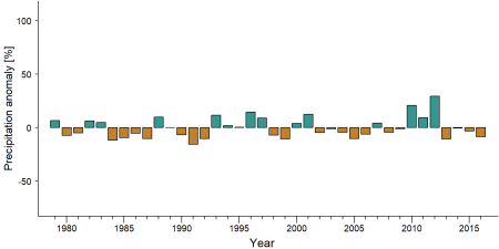
Precipitation anomaly in Semuliki National Park -
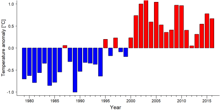
Temperature anomaly in Semuliki National Park


External links
References
BirdLife International. (2021). Important Bird Areas factsheet: Semliki National Park. Retrieved October 25, 2021, from http://www.birdlife.org
Plumptre, A. J., Cox, D., & Mugume, S. (2003). The status of chimpanzees in Uganda. Albertine Rift Technical Report Series No. 2. Wildlife Conservation Society. link
Rich, A. M., Wasserman, M. D., Hunt, K. D., & Kaestle, F. A. (2020). Chimpanzee (Pan troglodytes schweinfurthii) Population Spans Multiple Protected Areas in the Albertine Rift. Folia Primatologica, 91(6), 595-609. doi:10.1159/000508073
Sever, Z. (2021). Searching for the okapi (Okapia johnstoni) in Semuliki National Park, Uganda. African Journal of Ecology, 59(1), 286–292. doi:10.1111/aje.12796
Kiribou, R., Tehoda, P., Chukwu, O., Bempah, G., Kühl, H. S., Ferreira, J., …, & Heinicke, S. (2024). Exposure of African ape sites to climate change impacts. PLOS Climate, 3(2), e0000345. doi:10.1371/journal.pclm.0000345
AfricaSky. https://www.africaskysafari.com/semuliki-national-park
Page created by: APES Atlas Team Date: 2021-10-29