
ZICGC 9: Difference between revisions
No edit summary |
No edit summary Tag: Manual revert |
||
| (2 intermediate revisions by the same user not shown) | |||
| Line 17: | Line 17: | ||
= Site characteristics = | = Site characteristics = | ||
The site is located between the Boumba River and [[Lobéké National Park]], to the west of the Moloundou Road. ZICGC stands for ''Zones d'Intéret Cynégétique à Gestion Communautaire'', areas where communities can exploit flora and fauna under community-led management plans with the oversight of governmental conservation authorities (Nelson 2003). | The site is located between the Boumba River and [[Lobéké National Park]], to the west of the Moloundou Road. ZICGC stands for ''Zones d'Intéret Cynégétique à Gestion Communautaire'', areas where communities can exploit flora and fauna under community-led management plans with the oversight of governmental conservation authorities ([[#R01980|Nelson 2003]]). | ||
'''Table 1. Basic site information for ZICGC 9''' | '''Table 1. Basic site information for ZICGC 9''' | ||
| Line 44: | Line 44: | ||
= Ape status = | = Ape status = | ||
Within ZICGC 9, the areas with the highest gorilla population densities have been estimated to range between 4 to 6 individuals per km (Nelson & Venant 2008). | Within ZICGC 9, the areas with the highest gorilla population densities have been estimated to range between 4 to 6 individuals per km ([[#R01981|Nelson & Venant 2008]]). | ||
'''Table 2. Ape population estimates reported for ZICGC 9''' | '''Table 2. Ape population estimates reported for ZICGC 9''' | ||
| Line 89: | Line 89: | ||
= Challenges = | = Challenges = | ||
The selection criteria required for joining the group of community delegates responsible for managing the ZICGC such as the need for French literacy, mitigates against the membership of Baka community representatives. In 2002, less than 10% of the delegates for ZICGC 9 were from the Baka majority, and they were mainly chosen by local Bantu chiefs, not by the Baka themselves (Nelson 2003). As a result, management decisions can come into direct conflict with the livelihood strategies of the Baka. For example, the committee can allow safari companies access to primer forest hunting areas, which the Baka rely on for subsistence (Nelson 2003). | The selection criteria required for joining the group of community delegates responsible for managing the ZICGC such as the need for French literacy, mitigates against the membership of Baka community representatives. In 2002, less than 10% of the delegates for ZICGC 9 were from the Baka majority, and they were mainly chosen by local Bantu chiefs, not by the Baka themselves ([[#R01980|Nelson 2003]]). As a result, management decisions can come into direct conflict with the livelihood strategies of the Baka. For example, the committee can allow safari companies access to primer forest hunting areas, which the Baka rely on for subsistence ([[#R01980|Nelson 2003]]). | ||
'''Table 5. Challenges reported for ZICGC 9''' | '''Table 5. Challenges reported for ZICGC 9''' | ||
| Line 186: | Line 186: | ||
= Exposure to climate change impacts = | = Exposure to climate change impacts = | ||
As part of a study on the exposure of African great ape sites to climate change impacts, Kiribou et al. (2024) extracted climate data and data on projected extreme climate impact events for the site. Climatological characteristics were derived from observation-based climate data provided by the Inter-Sectoral Impact Model Intercomparison Project (ISIMIP, www.isimip.org). Parameters were calculated as the average across each 30-year period. For 1981-2010, the EWEMBI dataset from ISIMIP2a was used. For the two future periods (2021-2050 and 2071-2099) ISIMIP2b climate data based on four CMIP5 global climate models were used. For future projections, two Representative Concentration Pathways (RCP) were used. RCP 2.6 is a scenario with strong mitigation measures in which global temperatures would likely rise below 2C. RCP 6.0 is a scenario with medium emissions in which global temperatures would likely rise up to 3C by 2100. For the number of days with heavy precipitation events, the 98th percentile of all precipitation days (>1mm/d) was calculated for the 1979-2013 reference period as a threshold for a heavy precipitation event. Then, for each year, the number of days above that threshold was derived. The figures on temperature and precipitation anomaly show the deviation from the mean temperature and mean precipitation for the 1979-2013 reference period. | As part of a study on the exposure of African great ape sites to climate change impacts, [[#R02347|Kiribou et al. (2024)]] extracted climate data and data on projected extreme climate impact events for the site. Climatological characteristics were derived from observation-based climate data provided by the Inter-Sectoral Impact Model Intercomparison Project (ISIMIP, www.isimip.org). Parameters were calculated as the average across each 30-year period. For 1981-2010, the EWEMBI dataset from ISIMIP2a was used. For the two future periods (2021-2050 and 2071-2099) ISIMIP2b climate data based on four CMIP5 global climate models were used. For future projections, two Representative Concentration Pathways (RCP) were used. RCP 2.6 is a scenario with strong mitigation measures in which global temperatures would likely rise below 2C. RCP 6.0 is a scenario with medium emissions in which global temperatures would likely rise up to 3C by 2100. For the number of days with heavy precipitation events, the 98th percentile of all precipitation days (>1mm/d) was calculated for the 1979-2013 reference period as a threshold for a heavy precipitation event. Then, for each year, the number of days above that threshold was derived. The figures on temperature and precipitation anomaly show the deviation from the mean temperature and mean precipitation for the 1979-2013 reference period. | ||
The estimated exposure to future extreme climate impact events (crop failure, drought, river flood, wildfire, tropical cyclone, and heatwave) is based on a published dataset by Lange et al. 2020 derived from ISIMIP2b data. The same global climate models and RCPs as described above were used. Within each 30-year period, the number of years with an extreme event and the average proportion of the site affected were calculated (Kiribou et al. 2024). | The estimated exposure to future extreme climate impact events (crop failure, drought, river flood, wildfire, tropical cyclone, and heatwave) is based on a published dataset by Lange et al. 2020 derived from ISIMIP2b data. The same global climate models and RCPs as described above were used. Within each 30-year period, the number of years with an extreme event and the average proportion of the site affected were calculated ([[#R02347|Kiribou et al. 2024]]). | ||
'''Table 8. Estimated past and projected climatological characteristics in ZICGC 9''' | '''Table 8. Estimated past and projected climatological characteristics in ZICGC 9''' | ||
| Line 311: | Line 311: | ||
= References = | = References = | ||
Nelson, J. (2003). Cameroon: Baka losing out to Lobeke and Boumba National Parks. WRM bulletin, (67).Online: https://www.wrm.org.uy/bulletin-articles/cameroon-baka-losing-out-to-lobeke-and-boumba-national-parks | <span id="R01980"></span>Nelson, J. (2003). Cameroon: Baka losing out to Lobeke and Boumba National Parks. WRM bulletin, (67).Online: https://www.wrm.org.uy/bulletin-articles/cameroon-baka-losing-out-to-lobeke-and-boumba-national-parks | ||
Nelson, J., & Venant, M. (2008). Indigenous peoples’ participation in mapping of traditional forest resources for sustainable livelihoods and great ape conservation. United Nations Environment Programme/Forest Peoples Programme. | <span id="R01981"></span>Nelson, J., & Venant, M. (2008). Indigenous peoples’ participation in mapping of traditional forest resources for sustainable livelihoods and great ape conservation. United Nations Environment Programme/Forest Peoples Programme. | ||
<span id="R02347"></span>Kiribou, R., Tehoda, P., Chukwu, O., Bempah, G., Kühl, H. S., Ferreira, J., …, & Heinicke, S. (2024). Exposure of African ape sites to climate change impacts. ''PLOS Climate'', 3(2), e0000345. [https://doi.org/10.1371/journal.pclm.0000345 doi:10.1371/journal.pclm.0000345] | |||
'''Page created by: '''APES Atlas Team''' Date:''' 2023-05-19 | '''Page created by: '''APES Atlas Team''' Date:''' 2023-05-19 | ||
Latest revision as of 17:55, 15 October 2026
Central Africa > Cameroon > ZICGC 9
Français | Português | Español | Bahasa Indonesia | Melayu
Summary
- Central chimpanzees (Pan troglodytes troglodytes) & western lowland gorillas (Gorilla gorilla gorilla) are present in ZICGC 9.
- The population sizes are unknown.
- The great ape population trend is unknown.
- The site has a total size of approx 2,800 km².
- Key threats to great apes are not documented.
- Conservation activities are not documented.
Site characteristics
The site is located between the Boumba River and Lobéké National Park, to the west of the Moloundou Road. ZICGC stands for Zones d'Intéret Cynégétique à Gestion Communautaire, areas where communities can exploit flora and fauna under community-led management plans with the oversight of governmental conservation authorities (Nelson 2003).
Table 1. Basic site information for ZICGC 9
| Species | Pan troglodytes troglodytes, Gorilla gorilla gorilla |
| Area | |
| Coordinates | Lat: 2.267269 , Lon: 15.280241 |
| Type of site | Non-protected area (Community Forest) |
| Habitat types | Subtropical/tropical moist lowland forest, Subtropical/tropical swamp forest |
| Type of governance |
Types of sites Governance types Habitat types
Ape status
Within ZICGC 9, the areas with the highest gorilla population densities have been estimated to range between 4 to 6 individuals per km (Nelson & Venant 2008).
Table 2. Ape population estimates reported for ZICGC 9
| Species | Year | Occurrence | Encounter or vistation rate (nests/km; ind/day) | Density estimate [ind./ km²] (95% CI) | Abundance estimate (95% CI) | Survey area | Sampling method | Analytical framework | Source | Comments | A.P.E.S. database ID |
|---|---|---|---|---|---|---|---|---|---|---|---|
| Pan troglodytes troglodytes & Gorilla gorilla gorilla | ZICGC 9 |
Sampling methods Analytical frameworks
Threats
Conservation activities
Challenges
The selection criteria required for joining the group of community delegates responsible for managing the ZICGC such as the need for French literacy, mitigates against the membership of Baka community representatives. In 2002, less than 10% of the delegates for ZICGC 9 were from the Baka majority, and they were mainly chosen by local Bantu chiefs, not by the Baka themselves (Nelson 2003). As a result, management decisions can come into direct conflict with the livelihood strategies of the Baka. For example, the committee can allow safari companies access to primer forest hunting areas, which the Baka rely on for subsistence (Nelson 2003).
Table 5. Challenges reported for ZICGC 9
| Challenges | Specific challenges | Source | Year(s) |
|---|---|---|---|
| Not reported |
Enablers
Table 6. Enablers reported for ZICGC 9
| Enablers | Specific enablers | Source | Year(s) |
|---|---|---|---|
| 1 Site management | |||
| 2 Resources and capacity | |||
| 3 Engaged community | |||
| 4 Institutional support | |||
| 5 Ecological context | |||
| 6 Safety and stability |
Research activities
Documented behaviours
Table 7. Behaviours documented for ZICGC 9
| Category | Behavior | Observation type | Prevalence | Observation dates | Source | Habituation | Species | Comment |
|---|---|---|---|---|---|---|---|---|
| Not reported |
Exposure to climate change impacts
As part of a study on the exposure of African great ape sites to climate change impacts, Kiribou et al. (2024) extracted climate data and data on projected extreme climate impact events for the site. Climatological characteristics were derived from observation-based climate data provided by the Inter-Sectoral Impact Model Intercomparison Project (ISIMIP, www.isimip.org). Parameters were calculated as the average across each 30-year period. For 1981-2010, the EWEMBI dataset from ISIMIP2a was used. For the two future periods (2021-2050 and 2071-2099) ISIMIP2b climate data based on four CMIP5 global climate models were used. For future projections, two Representative Concentration Pathways (RCP) were used. RCP 2.6 is a scenario with strong mitigation measures in which global temperatures would likely rise below 2C. RCP 6.0 is a scenario with medium emissions in which global temperatures would likely rise up to 3C by 2100. For the number of days with heavy precipitation events, the 98th percentile of all precipitation days (>1mm/d) was calculated for the 1979-2013 reference period as a threshold for a heavy precipitation event. Then, for each year, the number of days above that threshold was derived. The figures on temperature and precipitation anomaly show the deviation from the mean temperature and mean precipitation for the 1979-2013 reference period.
The estimated exposure to future extreme climate impact events (crop failure, drought, river flood, wildfire, tropical cyclone, and heatwave) is based on a published dataset by Lange et al. 2020 derived from ISIMIP2b data. The same global climate models and RCPs as described above were used. Within each 30-year period, the number of years with an extreme event and the average proportion of the site affected were calculated (Kiribou et al. 2024).
Table 8. Estimated past and projected climatological characteristics in ZICGC 9
| Value | 1981-2010 | 2021-2050, RCP 2.6 | 2021-2050, RCP 6.0 | 2071-2099, RCP 2.6 | 2071-2099, RCP 6.0 |
|---|---|---|---|---|---|
| Mean temperature [C] | 24.6 | 26 | 25.9 | 26.2 | 27.3 |
| Annual precipitation [mm] | 1305 | 1327 | 1352 | 1378 | 1357 |
| Max no. consecutive dry days (per year) | 25.2 | 20.9 | 22.6 | 17.8 | 21.2 |
| No. days with heavy precipitation (per year) | 6.3 | 5.6 | 6.3 | 6.2 | 7.6 |
Table 9. Projected exposure of apes to extreme climate impact events in ZICGC 9
| Type | No. of years with event (2021-2050, RCP 2.6) | % of site exposed (2021-2050, RCP 2.6) | No. of years with event (2021-2050, RCP 6.0) | % of site exposed (2021-2050, RCP 6.0) | No. of years with event (2070-2099, RCP 2.6) | % of site exposed (2070-2099, RCP 2.6) | No. of years with event (2070-2099, RCP 6.0) | % of site exposed (2070-2099, RCP 6.0) |
|---|---|---|---|---|---|---|---|---|
| Crop failure | 7.5 | 0.04 | 6.5 | 0.03 | 8 | 0.08 | 19 | 0.05 |
| Drought | 0 | 0 | 0 | 0 | 0 | 0 | 0 | 0 |
| Heatwave | 5 | 50 | 4 | 100 | 5.5 | 100 | 12.5 | 100 |
| River flood | 0 | 0 | 0.25 | 0.01 | 0 | 0 | 0.5 | 0.14 |
| Tropical cyclone | 0 | 0 | 0 | 0 | 0 | 0 | 0 | 0 |
| Wildfire | 30 | 0.7 | 30 | 0.82 | 29 | 0.57 | 29 | 0.67 |
-
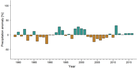
Precipitation anomaly in ZICGC 9 -
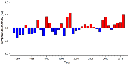
Temperature anomaly in ZICGC 9


External links
References
Nelson, J. (2003). Cameroon: Baka losing out to Lobeke and Boumba National Parks. WRM bulletin, (67).Online: https://www.wrm.org.uy/bulletin-articles/cameroon-baka-losing-out-to-lobeke-and-boumba-national-parks
Nelson, J., & Venant, M. (2008). Indigenous peoples’ participation in mapping of traditional forest resources for sustainable livelihoods and great ape conservation. United Nations Environment Programme/Forest Peoples Programme.
Kiribou, R., Tehoda, P., Chukwu, O., Bempah, G., Kühl, H. S., Ferreira, J., …, & Heinicke, S. (2024). Exposure of African ape sites to climate change impacts. PLOS Climate, 3(2), e0000345. doi:10.1371/journal.pclm.0000345
Page created by: APES Atlas Team Date: 2023-05-19