
Bugoma Central Forest Reserve: Difference between revisions
No edit summary |
No edit summary Tag: Manual revert |
||
| (7 intermediate revisions by the same user not shown) | |||
| Line 13: | Line 13: | ||
* Key threats to chimpanzees are hunting and clearing land for agriculture. | * Key threats to chimpanzees are hunting and clearing land for agriculture. | ||
* Conservation activities have focused on providing clean water access and raising conservation awareness. | * Conservation activities have focused on providing clean water access and raising conservation awareness. | ||
[[File:BugomaChimps.JPG | 350px | thumb| none | © Cat Hobaiter]] | [[File:BugomaChimps.JPG | 350px | thumb| none | © Cat Hobaiter]] | ||
| Line 48: | Line 44: | ||
= Ape status = | = Ape status = | ||
In 2006, the density of chimpanzees was estimated to be 1.99 chimpanzees/km² (Plumptre & Cox 2006). | In 2006, the density of chimpanzees was estimated to be 1.99 chimpanzees/km² ([[#R00250|Plumptre & Cox 2006]]). | ||
'''Table 2. Ape population estimates reported for Bugoma Central Forest Reserve''' | '''Table 2. Ape population estimates reported for Bugoma Central Forest Reserve''' | ||
| Line 74: | Line 70: | ||
|Line transects | |Line transects | ||
| | | | ||
|Plumptre & Cox 2006 | |[[#R00250|Plumptre & Cox 2006]] | ||
|Survey effort: 511.2 km | |Survey effort: 511.2 km | ||
| | | | ||
| Line 102: | Line 98: | ||
|2.1 Annual & perennial non-timber crops | |2.1 Annual & perennial non-timber crops | ||
|Present (unknown severity) | |Present (unknown severity) | ||
|Encroachment of forest habitat for farming affecting the boundaries (Hobaiter & Gruber pers. comm. 2020). Sugarcane companies are clearing land within the reserve (Lewton 2020). | |Encroachment of forest habitat for farming affecting the boundaries (Hobaiter & Gruber pers. comm. 2020). Sugarcane companies are clearing land within the reserve ([[#R00249|Lewton 2020]]). | ||
|Ongoing (2020) | |Ongoing (2020) | ||
|- | |- | ||
| Line 143: | Line 139: | ||
!Implementing organization(s) | !Implementing organization(s) | ||
!Year of activity | !Year of activity | ||
|- | |- | ||
|4 Education & awareness | |4 Education & awareness | ||
| Line 155: | Line 145: | ||
| | | | ||
|Ongoing (2020) | |Ongoing (2020) | ||
|- | |||
|5 Protection & restoration | |||
|5.2 Legally protect ape habitat | |||
|First gazetted in 1932. | |||
| | |||
|1932-Ongoing (2026) | |||
|- | |- | ||
|7 Economic & other incentives | |7 Economic & other incentives | ||
| Line 264: | Line 260: | ||
= Exposure to climate change impacts = | = Exposure to climate change impacts = | ||
As part of a study on the exposure of African great ape sites to climate change impacts, Kiribou et al. | As part of a study on the exposure of African great ape sites to climate change impacts, [[#R02163|Kiribou et al. (2024)]] extracted climate data and data on projected extreme climate impact events for the site. Climatological characteristics were derived from observation-based climate data provided by the Inter-Sectoral Impact Model Intercomparison Project (ISIMIP, www.isimip.org). Parameters were calculated as the average across each 30-year period. For 1981-2010, the EWEMBI dataset from ISIMIP2a was used. For the two future periods (2021-2050 and 2071-2099) ISIMIP2b climate data based on four CMIP5 global climate models were used. For future projections, two Representative Concentration Pathways (RCP) were used. RCP 2.6 is a scenario with strong mitigation measures in which global temperatures would likely rise below 2C. RCP 6.0 is a scenario with medium emissions in which global temperatures would likely rise up to 3C by 2100. For the number of days with heavy precipitation events, the 98th percentile of all precipitation days (>1mm/d) was calculated for the 1979-2013 reference period as a threshold for a heavy precipitation event. Then, for each year, the number of days above that threshold was derived. The figures on temperature and precipitation anomaly show the deviation from the mean temperature and mean precipitation for the 1979-2013 reference period. | ||
The estimated exposure to future extreme climate impact events (crop failure, drought, river flood, wildfire, tropical cyclone, and heatwave) is based on a published dataset by Lange et al. 2020 derived from ISIMIP2b data. The same global climate models and RCPs as described above were used. Within each 30-year period, the number of years with an extreme event and the average proportion of the site affected were calculated ( | The estimated exposure to future extreme climate impact events (crop failure, drought, river flood, wildfire, tropical cyclone, and heatwave) is based on a published dataset by Lange et al. 2020 derived from ISIMIP2b data. The same global climate models and RCPs as described above were used. Within each 30-year period, the number of years with an extreme event and the average proportion of the site affected were calculated ([[#R02163|Kiribou et al. 2024]]). | ||
'''Table 8. Estimated past and projected climatological characteristics in Bugoma Central Forest Reserve''' | '''Table 8. Estimated past and projected climatological characteristics in Bugoma Central Forest Reserve''' | ||
| Line 391: | Line 387: | ||
= References = | = References = | ||
Lewton, T. (2020, November 5). Uganda environment authority greenlights clearing of Bugoma Forest. | <span id="R00248"></span>Bugoma Primate Conservation Project. (n.d.). Research. https://bugomaprimates.wp.st-andrews.ac.uk/research/ | ||
<span id="R00249"></span>Lewton, T. (2020, November 5). Uganda environment authority greenlights clearing of Bugoma Forest. Mongabay. https://news.mongabay.com/2020/11/uganda-environment-authority-greenlights-clearing-of-bugoma-forest/ | |||
Plumptre, A.J., & Cox, D. (2006). Counting primates for conservation: primate surveys in Uganda. Primates, 47, 65-73. | <span id="R00250"></span>Plumptre, A. J., & Cox, D. (2006). Counting primates for conservation: primate surveys in Uganda. ''Primates'', 47(1), 65-73. [https://doi.org/10.1007/s10329-005-0146-8 doi:10.1007/s10329-005-0146-8] | ||
<span id="R02163"></span>Kiribou, R., Tehoda, P., Chukwu, O., Bempah, G., Kühl, H. S., Ferreira, J., …, & Heinicke, S. (2024). Exposure of African ape sites to climate change impacts. ''PLOS Climate'', 3(2), e0000345. [https://doi.org/10.1371/journal.pclm.0000345 doi:10.1371/journal.pclm.0000345] | |||
'''Page created by: '''Cat Hobaiter & Thibaud Gruber''' Date:''' 2020-11-18 | '''Page created by: '''Cat Hobaiter & Thibaud Gruber''' Date:''' 2020-11-18 | ||
Latest revision as of 17:52, 15 October 2026
East Africa > Uganda > Bugoma Central Forest Reserve
Français | Português | Español | Bahasa Indonesia | Melayu
Summary
- Eastern chimpanzees (Pan troglodytes schweinfurthii) are present in Bugoma Central Forest Reserve.
- The chimpanzee population size is unknown; the density in 2006 was 1.99 individuals per km².
- The chimpanzee population trend is unknown.
- The site has a total size of 400 km².
- Key threats to chimpanzees are hunting and clearing land for agriculture.
- Conservation activities have focused on providing clean water access and raising conservation awareness.

Site characteristics
Table 1. Basic site information for Bugoma Central Forest Reserve
| Species | Pan troglodytes schweinfurthii |
| Area | 400 km² |
| Coordinates | Lat: 1.304 , Lon: 31.016 |
| Type of site | Protected area (Forest Reserve) |
| Habitat types | Subtropical/tropical moist lowland |
| Type of governance |
Types of sites Governance types Habitat types
Ape status
In 2006, the density of chimpanzees was estimated to be 1.99 chimpanzees/km² (Plumptre & Cox 2006).
Table 2. Ape population estimates reported for Bugoma Central Forest Reserve
| Species | Year | Occurrence | Encounter or vistation rate (nests/km; ind/day) | Density estimate [ind./ km²] (95% CI) | Abundance estimate (95% CI) | Survey area | Sampling method | Analytical framework | Source | Comments | A.P.E.S. database ID |
|---|---|---|---|---|---|---|---|---|---|---|---|
| Pan troglodytes schweinfurthii | 2006 | 1.99 | Bugoma Forest | Line transects | Plumptre & Cox 2006 | Survey effort: 511.2 km |
Sampling methods Analytical frameworks
Threats
Table 3. Threats to apes reported for Bugoma Central Forest Reserve
| Category | Specific threats | Threat level | Description | Year of threat |
|---|---|---|---|---|
| 11 Climate change & severe weather | 11.1 Habitat shifting & alteration | Present (unknown severity) | Some evidence that there is decreasing fruiting in forest trees, perhaps impacted by increase in overnight temperature lows (Hobaiter & Gruber pers. comm. 2020). | Ongoing (2020) |
| 2 Agriculture & aquaculture | 2.1 Annual & perennial non-timber crops | Present (unknown severity) | Encroachment of forest habitat for farming affecting the boundaries (Hobaiter & Gruber pers. comm. 2020). Sugarcane companies are clearing land within the reserve (Lewton 2020). | Ongoing (2020) |
| 4 Transportation & service corridors | 4.1 Roads & railroads | Present (unknown severity) | Busy dirt road cuts through the main forest block and divides chimpanzees' (and other species') territory - danger from speeding vehicles (Hobaiter & Gruber pers. comm. 2020). | Ongoing (2020) |
| 5 Biological resource use | 5.1 Hunting & collecting terrestrial animals | Present (unknown severity) | Snares placed for duiker and bush pigs also trap chimpanzees. Chimpanzees are also directly targeted by hunters (Hobaiter & Gruber pers. comm. 2020). | Ongoing (2020) |
| 5 Biological resource use | 5.3 Logging & wood harvesting | Present (unknown severity) | Illegal logging is present throughout forest, in particular outside of the immediate research areas; includes chimpanzee feeding species. Trees illegally felled for charcoal burning and firewood, particularly around the boundaries (Hobaiter & Gruber pers. comm. 2020). | Ongoing (2020) |
| 8 Invasive & other problematic species, genes & diseases | 8.4 Pathogens | Present (unknown severity) | Respiratory outbreaks. Other sites in Uganda have confirmed similar respiratory pathogens of human origin (Hobaiter & Gruber pers. comm. 2020). | Ongoing (2020) |
Conservation activities
The Bugoma Primate Conservation Project was established in 2015, and works in collaboration with local communities surrounding the reserve on a number of conservation activities, including school classes, plastic waste recycling, and clean water programs.
Table 4. Conservation activities reported for Bugoma Central Forest Reserve
| Category | Specific activity | Description | Implementing organization(s) | Year of activity |
|---|---|---|---|---|
| 4 Education & awareness | 4.5 Implement multimedia campaigns using theatre, film, print media, discussions | The Bugoma Primate Conservation Project visits local schools and communities to talk about the Bugoma Forest, and hold conservation film nights (Bugoma Primate Conservation Project n.d., Hobaiter & Gruber pers. comm. 2020) | Ongoing (2020) | |
| 5 Protection & restoration | 5.2 Legally protect ape habitat | First gazetted in 1932. | 1932-Ongoing (2026) | |
| 7 Economic & other incentives | 7.2 Provide non-monetary benefits to local communities for sustainably managing their forest and its wildlife (e.g., better education, infrastructure development) | Clean water access program (Bugoma Primate Conservation Project n.d., Hobaiter & Gruber pers. comm. 2020) | Ongoing (2020) |
Challenges
Table 5. Challenges reported for Bugoma Central Forest Reserve
| Challenges | Specific challenges | Source | Year(s) |
|---|---|---|---|
| 6 Safety and stability | 6.3 Civil unrest/war | Hobaiter & Gruber pers. comm. 2020 |
Enablers
Table 6. Enablers reported for Bugoma Central Forest Reserve
| Enablers | Specific enablers | Source | Year(s) |
|---|---|---|---|
| 1 Site management | |||
| 2 Resources and capacity | |||
| 3 Engaged community | |||
| 4 Institutional support | |||
| 5 Ecological context | |||
| 6 Safety and stability |
Research activities
Following initial surveys in 2015, systematic habituation of chimpanzee communities started in 2016 and is ongoing. Several groups of Ugandan mangabey are already habituated. Systematic data collection on chimpanzee behaviour, forest tree phenology, illegal activities, rainfall, and temperature are collected by the Bugoma Primate Conservation Project.

Documented behaviours
Table 7. Behaviours documented for Bugoma Central Forest Reserve
| Category | Behavior | Observation type | Prevalence | Observation dates | Source | Habituation | Species | Comment |
|---|---|---|---|---|---|---|---|---|
| Not reported |
Exposure to climate change impacts
As part of a study on the exposure of African great ape sites to climate change impacts, Kiribou et al. (2024) extracted climate data and data on projected extreme climate impact events for the site. Climatological characteristics were derived from observation-based climate data provided by the Inter-Sectoral Impact Model Intercomparison Project (ISIMIP, www.isimip.org). Parameters were calculated as the average across each 30-year period. For 1981-2010, the EWEMBI dataset from ISIMIP2a was used. For the two future periods (2021-2050 and 2071-2099) ISIMIP2b climate data based on four CMIP5 global climate models were used. For future projections, two Representative Concentration Pathways (RCP) were used. RCP 2.6 is a scenario with strong mitigation measures in which global temperatures would likely rise below 2C. RCP 6.0 is a scenario with medium emissions in which global temperatures would likely rise up to 3C by 2100. For the number of days with heavy precipitation events, the 98th percentile of all precipitation days (>1mm/d) was calculated for the 1979-2013 reference period as a threshold for a heavy precipitation event. Then, for each year, the number of days above that threshold was derived. The figures on temperature and precipitation anomaly show the deviation from the mean temperature and mean precipitation for the 1979-2013 reference period.
The estimated exposure to future extreme climate impact events (crop failure, drought, river flood, wildfire, tropical cyclone, and heatwave) is based on a published dataset by Lange et al. 2020 derived from ISIMIP2b data. The same global climate models and RCPs as described above were used. Within each 30-year period, the number of years with an extreme event and the average proportion of the site affected were calculated (Kiribou et al. 2024).
Table 8. Estimated past and projected climatological characteristics in Bugoma Central Forest Reserve
| Value | 1981-2010 | 2021-2050, RCP 2.6 | 2021-2050, RCP 6.0 | 2071-2099, RCP 2.6 | 2071-2099, RCP 6.0 |
|---|---|---|---|---|---|
| Mean temperature [C] | 24.8 | 26 | 26 | 26.3 | 27.4 |
| Annual precipitation [mm] | 1168 | 1182 | 1239 | 1113 | 1364 |
| Max no. consecutive dry days (per year) | 27.4 | 27 | 30.1 | 28.4 | 29.6 |
| No. days with heavy precipitation (per year) | 6.1 | 5.2 | 4.4 | 5.8 | 8.1 |
Table 9. Projected exposure of apes to extreme climate impact events in Bugoma Central Forest Reserve
| Type | No. of years with event (2021-2050, RCP 2.6) | % of site exposed (2021-2050, RCP 2.6) | No. of years with event (2021-2050, RCP 6.0) | % of site exposed (2021-2050, RCP 6.0) | No. of years with event (2070-2099, RCP 2.6) | % of site exposed (2070-2099, RCP 2.6) | No. of years with event (2070-2099, RCP 6.0) | % of site exposed (2070-2099, RCP 6.0) |
|---|---|---|---|---|---|---|---|---|
| Crop failure | 2 | 0.36 | 2.5 | 0.33 | 1 | 0.42 | 1.5 | 0.31 |
| Drought | 0 | 0 | 0 | 0 | 0 | 0 | 0 | 0 |
| Heatwave | 1 | 100 | 0.5 | 50 | 0 | 0 | 6 | 100 |
| River flood | 1.5 | 0.4 | 6 | 15.69 | 0.5 | 0.01 | 8 | 11.69 |
| Tropical cyclone | 0 | 0 | 0 | 0 | 0 | 0 | 0 | 0 |
| Wildfire | 30 | 1.28 | 30 | 1 | 29 | 1.06 | 29 | 0.88 |
-
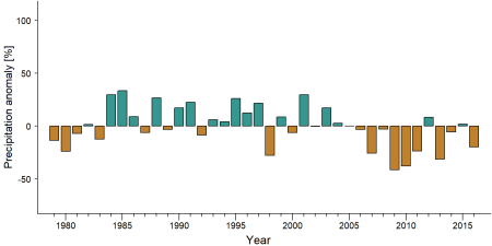
Precipitation anomaly in Bugoma Central Forest Reserve -
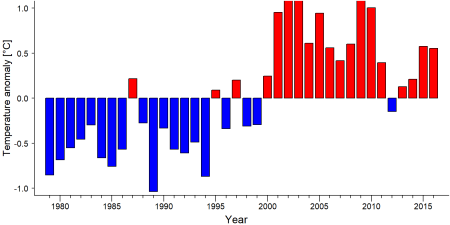
Temperature anomaly in Bugoma Central Forest Reserve


External links
Bugoma Primate Conservation Project
Bugoma Primate Conservation Project on Twitter
References
Bugoma Primate Conservation Project. (n.d.). Research. https://bugomaprimates.wp.st-andrews.ac.uk/research/
Lewton, T. (2020, November 5). Uganda environment authority greenlights clearing of Bugoma Forest. Mongabay. https://news.mongabay.com/2020/11/uganda-environment-authority-greenlights-clearing-of-bugoma-forest/
Plumptre, A. J., & Cox, D. (2006). Counting primates for conservation: primate surveys in Uganda. Primates, 47(1), 65-73. doi:10.1007/s10329-005-0146-8
Kiribou, R., Tehoda, P., Chukwu, O., Bempah, G., Kühl, H. S., Ferreira, J., …, & Heinicke, S. (2024). Exposure of African ape sites to climate change impacts. PLOS Climate, 3(2), e0000345. doi:10.1371/journal.pclm.0000345
Page created by: Cat Hobaiter & Thibaud Gruber Date: 2020-11-18