
Kyambura Wildlife Reserve: Difference between revisions
No edit summary |
No edit summary Tag: Manual revert |
||
| (8 intermediate revisions by the same user not shown) | |||
| Line 10: | Line 10: | ||
* It has been estimated that approximately 55 chimpanzees inhabit the site. | * It has been estimated that approximately 55 chimpanzees inhabit the site. | ||
* The chimpanzee population trend is unknown. | * The chimpanzee population trend is unknown. | ||
| Line 21: | Line 17: | ||
= Site characteristics = | = Site characteristics = | ||
Kyambura Wildlife Reserve (KWR), which encompasses the Kyambura Gorge, is situated south of Lake George and to the east of Queen Elizabeth National Park, near where the Kazinga Channel flows out of the lake towards Lake Albert (Zwick et al. 1997). The natural barriers created by the Kazinga Channel and the Kyambura Gorge serve to separate KWR from Queen Elizabeth National Park. However, both the park and the reserve are jointly managed by the Uganda Wildlife Authority as part of the Queen Elizabeth Protected Area (UWA 2012). | Kyambura Wildlife Reserve (KWR), which encompasses the Kyambura Gorge, is situated south of Lake George and to the east of Queen Elizabeth National Park, near where the Kazinga Channel flows out of the lake towards Lake Albert ([[#R00977|Zwick et al. 1997]]). The natural barriers created by the Kazinga Channel and the Kyambura Gorge serve to separate KWR from Queen Elizabeth National Park. However, both the park and the reserve are jointly managed by the Uganda Wildlife Authority as part of the Queen Elizabeth Protected Area ([[#R00973|UWA 2012]]). | ||
KWR was first designated as a Controlled Hunting Area in 1962 and later upgraded to a Game Reserve in 1965 (UWA 2023). It was used for licensed hunting and cropping, but due to civil unrest during the 1970s and 1980s, uncontrolled hunting significantly increased, leading to the decline of many large mammal species (Zwick et al. 1997). Following the Uganda Wildlife Statute of 1996, which reclassified all game reserves as wildlife reserves, the area officially became Kyambura Wildlife Reserve, and hunting concessions were terminated in 1999 due to illegal hunting activities (UWA 2012). | KWR was first designated as a Controlled Hunting Area in 1962 and later upgraded to a Game Reserve in 1965 (UWA 2023). It was used for licensed hunting and cropping, but due to civil unrest during the 1970s and 1980s, uncontrolled hunting significantly increased, leading to the decline of many large mammal species ([[#R00977|Zwick et al. 1997]]). Following the Uganda Wildlife Statute of 1996, which reclassified all game reserves as wildlife reserves, the area officially became Kyambura Wildlife Reserve, and hunting concessions were terminated in 1999 due to illegal hunting activities ([[#R00973|UWA 2012]]). | ||
The terrain of KWR is marked by small hills, ranging from 700 to 1,100 meters in altitude. The reserve features approximately seven volcanic craters with both saline and fresh water bodies (Zwick et al. 1997). The Kyambura Gorge, formed through faulting, cuts through the savannah landscape, with the Kyambura River running along the gorge. The vegetation includes a riverine forest dominated by ''Cynometra'' sp. and ''Ficus'' sp. (Kruger et al., 1998), which transitions into swamp forest and papyrus swamp near the mouth of the Kyambura River. The eastern boundary of KWR follows the Buhindagi River, which connects Lake George to the Kasyoha-Kitomi Forest Reserve (Zwick et al. 1997), forming an essential migratory corridor known as the Kyambura Gorge-Kasyoha Kitomi corridor. To the north, the reserve is bordered by savannah grasslands (UWA 2012). | The terrain of KWR is marked by small hills, ranging from 700 to 1,100 meters in altitude. The reserve features approximately seven volcanic craters with both saline and fresh water bodies ([[#R00977|Zwick et al. 1997]]). The Kyambura Gorge, formed through faulting, cuts through the savannah landscape, with the Kyambura River running along the gorge. The vegetation includes a riverine forest dominated by ''Cynometra'' sp. and ''Ficus'' sp. (Kruger et al., 1998), which transitions into swamp forest and papyrus swamp near the mouth of the Kyambura River. The eastern boundary of KWR follows the Buhindagi River, which connects Lake George to the Kasyoha-Kitomi Forest Reserve ([[#R00977|Zwick et al. 1997]]), forming an essential migratory corridor known as the Kyambura Gorge-Kasyoha Kitomi corridor. To the north, the reserve is bordered by savannah grasslands ([[#R00973|UWA 2012]]). | ||
KWR's ecosystem is similar to that of Queen Elizabeth National Park, hosting comparable wildlife, including mammals such as hippopotamuses, lions, leopards, elephants, buffalo, various antelopes, and smaller ungulates (UWA 2023). KWR is a Key Biodiversity Area (KBA 2025). A total of 332 bird species were reported by Byaruhanga et al. (2001). Kyambura Gorge is renowned for its high concentration of primates, including chimpanzees. The chimpanzee population in the gorge is said to consist of a single community of fewer than 30 individuals. This community has become isolated due to the clearing of corridors that once connected it to larger forests such as Kalinzu and Maramagambo, raising concerns about potential inbreeding and genetic mutations (UWA 2012). | KWR's ecosystem is similar to that of Queen Elizabeth National Park, hosting comparable wildlife, including mammals such as hippopotamuses, lions, leopards, elephants, buffalo, various antelopes, and smaller ungulates (UWA 2023). KWR is a Key Biodiversity Area ([[#R00969|KBA 2025]]). A total of 332 bird species were reported by [[#R00968|Byaruhanga et al. (2001)]]. Kyambura Gorge is renowned for its high concentration of primates, including chimpanzees. The chimpanzee population in the gorge is said to consist of a single community of fewer than 30 individuals. This community has become isolated due to the clearing of corridors that once connected it to larger forests such as Kalinzu and Maramagambo, raising concerns about potential inbreeding and genetic mutations ([[#R00973|UWA 2012]]). | ||
'''Table 1. Basic site information for Kyambura Wildlife Reserve''' | '''Table 1. Basic site information for Kyambura Wildlife Reserve''' | ||
| Line 79: | Line 75: | ||
|Reconnaissance walk | |Reconnaissance walk | ||
|Distance sampling (decay time unknown) | |Distance sampling (decay time unknown) | ||
|Plumptre, Cox & Mugume 2003, Allan 1994 | |[[#R00972|Plumptre, Cox & Mugume 2003]], [[#R00967|Allan 1994]] | ||
|Survey classified site as a low density site hence density estimates were not possible. Only 50 nest building chimpanzees were estimated by the study. | |Survey classified site as a low density site hence density estimates were not possible. Only 50 nest building chimpanzees were estimated by the study. | ||
| | | | ||
| Line 97: | Line 93: | ||
!Description | !Description | ||
!Year of threat | !Year of threat | ||
|- | |- | ||
|2 Agriculture & aquaculture | |2 Agriculture & aquaculture | ||
|2.1.2 Small-holder farming | |2.1.2 Small-holder farming | ||
|Present (unknown severity) | |Present (unknown severity) | ||
|Intensive cultivation along the Kyambura River restricting favorable habitats for chimpanzees (WCS 2008). | |Intensive cultivation along the Kyambura River restricting favorable habitats for chimpanzees ([[#R00976|WCS 2008]]). | ||
|1990-Ongoing (2008) | |1990-Ongoing (2008) | ||
|- | |- | ||
| | |4 Transportation & service corridors | ||
| | |4.1 Roads & railroads | ||
| | |Present (unknown severity) | ||
| | |The growing road network and power line, cutting through the Kyambura gorge corridor and its escarpment banks that links Kyambura and Kasyoha-Kitomi, make deep intrusions into the underground riparian forest that is a home to chimpanzees (BirdLife International 2025). | ||
| | |Ongoing (2025) | ||
|- | |||
|5 Biological resource use | |||
|5.1.2 Unintentional effects | |||
|High (more than 70% of population affected) | |||
|Poaching for commercial and subsistence use, using firearms (including automatic weapons such as the AK47), wire snares, nets and various types of foot traps ([[#R00973|UWA 2012]]). High intensity registered between 1970s -1980 due to civil unrest ([[#R00977|Zwick et al. 1997]]). Risk of chimpanzees being ensnared or trapped by traps made for other animals. | |||
|1970-Ongoing (2012) | |||
|- | |- | ||
|5 Biological resource use | |5 Biological resource use | ||
|5.3 Logging & wood harvesting | |5.3 Logging & wood harvesting | ||
|Present (unknown severity) | |Present (unknown severity) | ||
|Logging and harvesting of wood has reduced abundance of fig trees which are critical to survival of primates in such savanna habitats (WCS 2008). | |Logging and harvesting of wood has reduced abundance of fig trees which are critical to survival of primates in such savanna habitats ([[#R00976|WCS 2008]]). | ||
|Ongoing (2008) | |Ongoing (2008) | ||
|- | |||
|6 Human intrusions & disturbance | |||
|6.2 War, civil unrest & military exercises | |||
|Low (up to 30% of population affected) | |||
|Civil unrest between 1970s and early 1980s ([[#R00968|Byaruhanga et al. 2001]]). | |||
|1970-1980 | |||
|- | |- | ||
|7 Natural system modifications | |7 Natural system modifications | ||
|7.1 Fire & fire suppression | |7.1 Fire & fire suppression | ||
|Low (up to 30% of population affected) | |Low (up to 30% of population affected) | ||
|The fires are mostly started by poachers who use fires as a means of hunting. Other sources of fires include cigarettes that were not extinguished and fires originating from community farmland or intentionally set by the community members (UWA 2012). | |The fires are mostly started by poachers who use fires as a means of hunting. Other sources of fires include cigarettes that were not extinguished and fires originating from community farmland or intentionally set by the community members ([[#R00973|UWA 2012]]). | ||
|Ongoing (2012) | |Ongoing (2012) | ||
|- | |- | ||
| | |7 Natural system modifications | ||
| | |7.2 Dams & water management/use | ||
| | |Low (up to 30% of population affected) | ||
|The | |The hydropower project was proposed for development in 2011 ([[#R00973|UWA 2012]]), constructed in 2017, and made operational in 2019 ([[#R00971|New Vision n.d]].). | ||
|Ongoing ( | |2017-Ongoing (2019) | ||
|} | |} | ||
| Line 154: | Line 150: | ||
!Implementing organization(s) | !Implementing organization(s) | ||
!Year of activity | !Year of activity | ||
|- | |- | ||
|2 Counter-wildlife crime | |2 Counter-wildlife crime | ||
|2.13 Provide sustainable alternative livelihoods; establish fish- or domestic meat farms | |2.13 Provide sustainable alternative livelihoods; establish fish- or domestic meat farms | ||
|Diversifying local livelihoods and improving smart crop and husbandry under the ''Kyambura Gorge Eco-tourism Project'' (Volcanoes Safari 2025). | |Diversifying local livelihoods and improving smart crop and husbandry under the ''Kyambura Gorge Eco-tourism Project'' ([[#R00975|Volcanoes Safari 2025]]). | ||
|Volcanoes Safaris and Volcanoes Safaris Partnership, Jane Goodall Institute, Uganda Trust | |Volcanoes Safaris and Volcanoes Safaris Partnership, Jane Goodall Institute, Uganda Trust | ||
|2009-Ongoing (2025) | |2009-Ongoing (2025) | ||
| Line 181: | Line 159: | ||
|4 Education & awareness | |4 Education & awareness | ||
|4.1 Educate local communities about apes and sustainable use | |4.1 Educate local communities about apes and sustainable use | ||
|Expanding community outreach programs through the Jane Goodall Institute Roots & Shoots program and the Volcanoes Safaris Partnership Community Centre, teaching them of the benefits of tourism and the natural value of the wildlife diversity in the area (Volcanoes Safari 2025). | |Expanding community outreach programs through the Jane Goodall Institute Roots & Shoots program and the Volcanoes Safaris Partnership Community Centre, teaching them of the benefits of tourism and the natural value of the wildlife diversity in the area ([[#R00975|Volcanoes Safari 2025]]). | ||
|Volcano Safaris and Volcano Safaris Partnership, Jane Goodall Institute, Uganda Trust | |Volcano Safaris and Volcano Safaris Partnership, Jane Goodall Institute, Uganda Trust | ||
|Ongoing (2025) | |Ongoing (2025) | ||
| Line 187: | Line 165: | ||
|5 Protection & restoration | |5 Protection & restoration | ||
|5.1 Create buffer zones around protected ape habitat | |5.1 Create buffer zones around protected ape habitat | ||
|The southeastern part of the reserve is protected as a wilderness zone, receiving minimal disturbance (UWA 2025). | |The southeastern part of the reserve is protected as a wilderness zone, receiving minimal disturbance ([[#R00974|UWA 2025]]). | ||
|Uganda Wildlife Authority | |Uganda Wildlife Authority | ||
|Ongoing (2025) | |Ongoing (2025) | ||
|- | |||
|5 Protection & restoration | |||
|5.2 Legally protect ape habitat | |||
|The are was gazetted as a wildlife reserve in 1966 ([[#R00974|UWA 2025]]). | |||
|Uganda Wildlife Authority | |||
|1997-Ongoing (2026) | |||
|- | |- | ||
|5 Protection & restoration | |5 Protection & restoration | ||
|5.4 Create natural habitat patches (including corridors) | |5.4 Create natural habitat patches (including corridors) | ||
|Volcano Safaris in Kyambura are buying land from communities in the corridor that links Kyambura Gorge to Kasyoha Kitomi Forest Reserve (Volcanoes Safari 2025). | |Volcano Safaris in Kyambura are buying land from communities in the corridor that links Kyambura Gorge to Kasyoha Kitomi Forest Reserve ([[#R00975|Volcanoes Safari 2025]]). | ||
|Volcanoes Safaris, Uganda Wildlife Authority | |Volcanoes Safaris, Uganda Wildlife Authority | ||
|Ongoing (2025) | |Ongoing (2025) | ||
| Line 199: | Line 183: | ||
|5 Protection & restoration | |5 Protection & restoration | ||
|5.6 Habitat restoration | |5.6 Habitat restoration | ||
|Planting of over 6000 trees as a way of recovering the vegetation, in corridors such as Kyambura Gorge-Kasyoha Kitomi corridor (Volcanoes Safari 2025). | |Planting of over 6000 trees as a way of recovering the vegetation, in corridors such as Kyambura Gorge-Kasyoha Kitomi corridor ([[#R00975|Volcanoes Safari 2025]]). | ||
|Volcanoes Safaris, Uganda Wildlife Authority | |Volcanoes Safaris, Uganda Wildlife Authority | ||
|Ongoing (2025) | |Ongoing (2025) | ||
|- | |||
|5 Protection & restoration | |||
|5.9 Resettle illegal human communities (i.e., in a protected area) to another location | |||
|A group of subsistence farmers from around reserve and from southern Uganda annexed land in the southeastern part of the reserve. These encroachers evicted in 1992 ([[#R00968|Byaruhanga et al. 2001]]). | |||
| | |||
|1992 | |||
|- | |||
|8 Permanent presence | |||
|8.2 Run tourist projects and ensure permanent human presence at site | |||
|UWA establised the Kyambura base camp which is an entry and access point for tourists ([[#R00973|UWA 2012]]). | |||
|Uganda Wildlife Authority | |||
|1997-Ongoing (2012) | |||
|} | |} | ||
| Line 219: | Line 215: | ||
|2 Resources and capacity | |2 Resources and capacity | ||
|2.2 Lack of staff | |2.2 Lack of staff | ||
|UWA 2012 | |[[#R00973|UWA 2012]] | ||
|Ongoing (2012) | |Ongoing (2012) | ||
|- | |- | ||
|2 Resources and capacity | |2 Resources and capacity | ||
|2.7 Lack of infrastructure | |2.7 Lack of infrastructure | ||
|UWA 2012 | |[[#R00973|UWA 2012]] | ||
|Ongoing (2012) | |Ongoing (2012) | ||
|- | |- | ||
|5 Ecological context | |5 Ecological context | ||
|5.1 Ecological constraints (e.g., susceptibility to climate change, difficult terrain) | |5.1 Ecological constraints (e.g., susceptibility to climate change, difficult terrain) | ||
|UWA 2012 | |[[#R00973|UWA 2012]] | ||
|Ongoing (2012) | |Ongoing (2012) | ||
|} | |} | ||
| Line 248: | Line 244: | ||
|2 Resources and capacity | |2 Resources and capacity | ||
|2.1 Sufficient staff | |2.1 Sufficient staff | ||
|UWA 2012 | |[[#R00973|UWA 2012]] | ||
|Ongoing (2012) | |Ongoing (2012) | ||
|- | |- | ||
|2 Resources and capacity | |2 Resources and capacity | ||
|2.6 External partnerships that add expertise or resources | |2.6 External partnerships that add expertise or resources | ||
|UWA 2012 | |[[#R00973|UWA 2012]] | ||
|Ongoing (2012) | |Ongoing (2012) | ||
|} | |} | ||
| Line 295: | Line 291: | ||
= Exposure to climate change impacts = | = Exposure to climate change impacts = | ||
As part of a study on the exposure of African great ape sites to climate change impacts, Kiribou et al. | As part of a study on the exposure of African great ape sites to climate change impacts, [[#R02236|Kiribou et al. (2024)]] extracted climate data and data on projected extreme climate impact events for the site. Climatological characteristics were derived from observation-based climate data provided by the Inter-Sectoral Impact Model Intercomparison Project (ISIMIP, www.isimip.org). Parameters were calculated as the average across each 30-year period. For 1981-2010, the EWEMBI dataset from ISIMIP2a was used. For the two future periods (2021-2050 and 2071-2099) ISIMIP2b climate data based on four CMIP5 global climate models were used. For future projections, two Representative Concentration Pathways (RCP) were used. RCP 2.6 is a scenario with strong mitigation measures in which global temperatures would likely rise below 2C. RCP 6.0 is a scenario with medium emissions in which global temperatures would likely rise up to 3C by 2100. For the number of days with heavy precipitation events, the 98th percentile of all precipitation days (>1mm/d) was calculated for the 1979-2013 reference period as a threshold for a heavy precipitation event. Then, for each year, the number of days above that threshold was derived. The figures on temperature and precipitation anomaly show the deviation from the mean temperature and mean precipitation for the 1979-2013 reference period. | ||
The estimated exposure to future extreme climate impact events (crop failure, drought, river flood, wildfire, tropical cyclone, and heatwave) is based on a published dataset by Lange et al. 2020 derived from ISIMIP2b data. The same global climate models and RCPs as described above were used. Within each 30-year period, the number of years with an extreme event and the average proportion of the site affected were calculated ( | The estimated exposure to future extreme climate impact events (crop failure, drought, river flood, wildfire, tropical cyclone, and heatwave) is based on a published dataset by Lange et al. 2020 derived from ISIMIP2b data. The same global climate models and RCPs as described above were used. Within each 30-year period, the number of years with an extreme event and the average proportion of the site affected were calculated ([[#R02236|Kiribou et al. 2024]]). | ||
'''Table 8. Estimated past and projected climatological characteristics in Kyambura Wildlife Reserve''' | '''Table 8. Estimated past and projected climatological characteristics in Kyambura Wildlife Reserve''' | ||
| Line 420: | Line 416: | ||
= References = | = References = | ||
Allan, C. (1994). Kyambura Game Reserve, Uganda. Preliminary results of Frontier Uganda Biological Assessment. Frontier, The Society for Environmental Exploration report. | <span id="R00967"></span>Allan, C. (1994). Kyambura Game Reserve, Uganda. Preliminary results of Frontier Uganda Biological Assessment. Frontier, The Society for Environmental Exploration report. | ||
<span id="R00968"></span>Byaruhanga, A., Kasoma, P., & Pomeroy, D. (2001). Important Bird Areas in Africa and associated islands—Uganda. In ''Fishpool, L. D., & Evans, M. I. (Eds.), Important Bird Areas in Africa and associated islands: Priority sites for conservation (pp''. 975–1003), Cambridge: BirdLife International. | |||
<span id="R00969"></span>Key Biodiversity Areas Partnership. (2025). Key Biodiversity Areas factsheet: Kyambura Wildlife Reserve. Extracted from the World Database of Key Biodiversity Areas. Developed by the Key Biodiversity Areas Partnership: BirdLife International, IUCN, American Bird Conservancy, Amphibian Survival Alliance, Conservation International, Critical Ecosystem Partnership Fund, Global Environment Facility, Re:wild, NatureServe, Rainforest Trust, Royal Society for the Protection of Birds, World Wildlife Fund, and Wildlife Conservation Society. Downloaded from https://keybiodiversityareas.org/ on March 10, 2025. | |||
<span id="R00970"></span>Krüger, O., Affeldt, E., Brackmann, M., & Milhahn, K. (1998). Group Size and Composition of Colobus guereza in Kyambura Gorge, Southwest Uganda, in Relation to Chimpanzee Activity. ''International Journal of Primatology'', 19(2), 287-297. [https://doi.org/10.1023/a:1020383600015 doi:10.1023/a:1020383600015] | |||
<span id="R00971"></span>New Vision. (n.d.). Uganda increases power generation with more dams. https://www.newvision.co.ug/news/1513829/uganda-increases-power-generation-dams | |||
<span id="R00972"></span>Plumptre, A. J., Cox, D., & Mugume, S. (2003). The status of chimpanzees in Uganda. Albertine Rift Technical Report Series No. 2. Wildlife Conservation Society, New York. [http://programs.wcs.org/portals/49/media/file/AR_Tech_Rpt_2_Uganda_Chimps.PDF link] | |||
<span id="R00973"></span>UWA. (2012). Queen Elizabeth National Park, Kyambura Wildlife Reserve and Kigezi Wildlife Reserve: General Management Plan (2011–2021). Kampala, Uganda. | |||
<span id="R00974"></span>UWA. (2025). Kyambura. https://ugandawildlife.org/wildlifereserves/kyambura/ Retrieved on March 13, 2025. | |||
<span id="R00975"></span>Volcanoes Safaris. (2025). Kyambura Community Projects, Kyambura Gorge Eco-tourism Project. https://volcanoessafaris.com/kyambura-community-projects/ Retrieved on March 13, 2025. | |||
<span id="R00976"></span>WCS. (2008). Queen Elizabeth Conservation Area Corridor Action Plan, 2008. Wildlife Conservation Society (WCS), Kampala. | |||
<span id="R00977"></span>Zwick, K. L., Stubblefield, L., Allan, C., Sivell, D., Lloyd, J., & Cunneyworth, P. (1997). Methods manual. Frontier Protected Areas Project Baseline Surveys Programme, The Society for Environmental Exploration, London & Uganda. | |||
<span id="R02236"></span>Kiribou, R., Tehoda, P., Chukwu, O., Bempah, G., Kühl, H. S., Ferreira, J., …, & Heinicke, S. (2024). Exposure of African ape sites to climate change impacts. ''PLOS Climate'', 3(2), e0000345. [https://doi.org/10.1371/journal.pclm.0000345 doi:10.1371/journal.pclm.0000345] | |||
'''Page created by: '''Steven Joel Basiibye''' Date:''' 2024-11-20 | '''Page created by: '''Steven Joel Basiibye''' Date:''' 2024-11-20 | ||
Latest revision as of 17:53, 15 October 2026
East Africa > Uganda > Kyambura Wildlife Reserve
Français | Português | Español | Bahasa Indonesia | Melayu
Summary
- Eastern chimpanzees (Pan troglodytes schweinfurthii) are present in Kyambura Wildlife Reserve.
- It has been estimated that approximately 55 chimpanzees inhabit the site.
- The chimpanzee population trend is unknown.
Site characteristics
Kyambura Wildlife Reserve (KWR), which encompasses the Kyambura Gorge, is situated south of Lake George and to the east of Queen Elizabeth National Park, near where the Kazinga Channel flows out of the lake towards Lake Albert (Zwick et al. 1997). The natural barriers created by the Kazinga Channel and the Kyambura Gorge serve to separate KWR from Queen Elizabeth National Park. However, both the park and the reserve are jointly managed by the Uganda Wildlife Authority as part of the Queen Elizabeth Protected Area (UWA 2012).
KWR was first designated as a Controlled Hunting Area in 1962 and later upgraded to a Game Reserve in 1965 (UWA 2023). It was used for licensed hunting and cropping, but due to civil unrest during the 1970s and 1980s, uncontrolled hunting significantly increased, leading to the decline of many large mammal species (Zwick et al. 1997). Following the Uganda Wildlife Statute of 1996, which reclassified all game reserves as wildlife reserves, the area officially became Kyambura Wildlife Reserve, and hunting concessions were terminated in 1999 due to illegal hunting activities (UWA 2012).
The terrain of KWR is marked by small hills, ranging from 700 to 1,100 meters in altitude. The reserve features approximately seven volcanic craters with both saline and fresh water bodies (Zwick et al. 1997). The Kyambura Gorge, formed through faulting, cuts through the savannah landscape, with the Kyambura River running along the gorge. The vegetation includes a riverine forest dominated by Cynometra sp. and Ficus sp. (Kruger et al., 1998), which transitions into swamp forest and papyrus swamp near the mouth of the Kyambura River. The eastern boundary of KWR follows the Buhindagi River, which connects Lake George to the Kasyoha-Kitomi Forest Reserve (Zwick et al. 1997), forming an essential migratory corridor known as the Kyambura Gorge-Kasyoha Kitomi corridor. To the north, the reserve is bordered by savannah grasslands (UWA 2012). KWR's ecosystem is similar to that of Queen Elizabeth National Park, hosting comparable wildlife, including mammals such as hippopotamuses, lions, leopards, elephants, buffalo, various antelopes, and smaller ungulates (UWA 2023). KWR is a Key Biodiversity Area (KBA 2025). A total of 332 bird species were reported by Byaruhanga et al. (2001). Kyambura Gorge is renowned for its high concentration of primates, including chimpanzees. The chimpanzee population in the gorge is said to consist of a single community of fewer than 30 individuals. This community has become isolated due to the clearing of corridors that once connected it to larger forests such as Kalinzu and Maramagambo, raising concerns about potential inbreeding and genetic mutations (UWA 2012).
Table 1. Basic site information for Kyambura Wildlife Reserve
| Species | Pan troglodytes schweinfurthii |
| Area | 157 km² |
| Coordinates | Lat: -0.11037 , Lon: 30.18194 |
| Type of site | Protected area (Wildlife Reserve) |
| Habitat types | Subtropical/tropical swamp forest, Savanna, Grassland, Wetlands (lakes, rivers, streams, bogs, marshes) |
| Type of governance | Governance by government |
Types of sites Governance types Habitat types
Ape status
Table 2. Ape population estimates reported for Kyambura Wildlife Reserve
| Species | Year | Occurrence | Encounter or vistation rate (nests/km; ind/day) | Density estimate [ind./ km²] (95% CI) | Abundance estimate (95% CI) | Survey area | Sampling method | Analytical framework | Source | Comments | A.P.E.S. database ID |
|---|---|---|---|---|---|---|---|---|---|---|---|
| Pan troglodytes schweinfurthii | 1992 | 55.05 (30-70) | Kyambura Wildlife Reserve | Reconnaissance walk | Distance sampling (decay time unknown) | Plumptre, Cox & Mugume 2003, Allan 1994 | Survey classified site as a low density site hence density estimates were not possible. Only 50 nest building chimpanzees were estimated by the study. |
Sampling methods Analytical frameworks
Threats
Table 3. Threats to apes reported for Kyambura Wildlife Reserve
| Category | Specific threats | Threat level | Description | Year of threat |
|---|---|---|---|---|
| 2 Agriculture & aquaculture | 2.1.2 Small-holder farming | Present (unknown severity) | Intensive cultivation along the Kyambura River restricting favorable habitats for chimpanzees (WCS 2008). | 1990-Ongoing (2008) |
| 4 Transportation & service corridors | 4.1 Roads & railroads | Present (unknown severity) | The growing road network and power line, cutting through the Kyambura gorge corridor and its escarpment banks that links Kyambura and Kasyoha-Kitomi, make deep intrusions into the underground riparian forest that is a home to chimpanzees (BirdLife International 2025). | Ongoing (2025) |
| 5 Biological resource use | 5.1.2 Unintentional effects | High (more than 70% of population affected) | Poaching for commercial and subsistence use, using firearms (including automatic weapons such as the AK47), wire snares, nets and various types of foot traps (UWA 2012). High intensity registered between 1970s -1980 due to civil unrest (Zwick et al. 1997). Risk of chimpanzees being ensnared or trapped by traps made for other animals. | 1970-Ongoing (2012) |
| 5 Biological resource use | 5.3 Logging & wood harvesting | Present (unknown severity) | Logging and harvesting of wood has reduced abundance of fig trees which are critical to survival of primates in such savanna habitats (WCS 2008). | Ongoing (2008) |
| 6 Human intrusions & disturbance | 6.2 War, civil unrest & military exercises | Low (up to 30% of population affected) | Civil unrest between 1970s and early 1980s (Byaruhanga et al. 2001). | 1970-1980 |
| 7 Natural system modifications | 7.1 Fire & fire suppression | Low (up to 30% of population affected) | The fires are mostly started by poachers who use fires as a means of hunting. Other sources of fires include cigarettes that were not extinguished and fires originating from community farmland or intentionally set by the community members (UWA 2012). | Ongoing (2012) |
| 7 Natural system modifications | 7.2 Dams & water management/use | Low (up to 30% of population affected) | The hydropower project was proposed for development in 2011 (UWA 2012), constructed in 2017, and made operational in 2019 (New Vision n.d.). | 2017-Ongoing (2019) |
Conservation activities
Table 4. Conservation activities reported for Kyambura Wildlife Reserve
| Category | Specific activity | Description | Implementing organization(s) | Year of activity |
|---|---|---|---|---|
| 2 Counter-wildlife crime | 2.13 Provide sustainable alternative livelihoods; establish fish- or domestic meat farms | Diversifying local livelihoods and improving smart crop and husbandry under the Kyambura Gorge Eco-tourism Project (Volcanoes Safari 2025). | Volcanoes Safaris and Volcanoes Safaris Partnership, Jane Goodall Institute, Uganda Trust | 2009-Ongoing (2025) |
| 4 Education & awareness | 4.1 Educate local communities about apes and sustainable use | Expanding community outreach programs through the Jane Goodall Institute Roots & Shoots program and the Volcanoes Safaris Partnership Community Centre, teaching them of the benefits of tourism and the natural value of the wildlife diversity in the area (Volcanoes Safari 2025). | Volcano Safaris and Volcano Safaris Partnership, Jane Goodall Institute, Uganda Trust | Ongoing (2025) |
| 5 Protection & restoration | 5.1 Create buffer zones around protected ape habitat | The southeastern part of the reserve is protected as a wilderness zone, receiving minimal disturbance (UWA 2025). | Uganda Wildlife Authority | Ongoing (2025) |
| 5 Protection & restoration | 5.2 Legally protect ape habitat | The are was gazetted as a wildlife reserve in 1966 (UWA 2025). | Uganda Wildlife Authority | 1997-Ongoing (2026) |
| 5 Protection & restoration | 5.4 Create natural habitat patches (including corridors) | Volcano Safaris in Kyambura are buying land from communities in the corridor that links Kyambura Gorge to Kasyoha Kitomi Forest Reserve (Volcanoes Safari 2025). | Volcanoes Safaris, Uganda Wildlife Authority | Ongoing (2025) |
| 5 Protection & restoration | 5.6 Habitat restoration | Planting of over 6000 trees as a way of recovering the vegetation, in corridors such as Kyambura Gorge-Kasyoha Kitomi corridor (Volcanoes Safari 2025). | Volcanoes Safaris, Uganda Wildlife Authority | Ongoing (2025) |
| 5 Protection & restoration | 5.9 Resettle illegal human communities (i.e., in a protected area) to another location | A group of subsistence farmers from around reserve and from southern Uganda annexed land in the southeastern part of the reserve. These encroachers evicted in 1992 (Byaruhanga et al. 2001). | 1992 | |
| 8 Permanent presence | 8.2 Run tourist projects and ensure permanent human presence at site | UWA establised the Kyambura base camp which is an entry and access point for tourists (UWA 2012). | Uganda Wildlife Authority | 1997-Ongoing (2012) |
Challenges
Table 5. Challenges reported for Kyambura Wildlife Reserve
| Challenges | Specific challenges | Source | Year(s) |
|---|---|---|---|
| 2 Resources and capacity | 2.2 Lack of staff | UWA 2012 | Ongoing (2012) |
| 2 Resources and capacity | 2.7 Lack of infrastructure | UWA 2012 | Ongoing (2012) |
| 5 Ecological context | 5.1 Ecological constraints (e.g., susceptibility to climate change, difficult terrain) | UWA 2012 | Ongoing (2012) |
Enablers
Table 6. Enablers reported for Kyambura Wildlife Reserve
| Enablers | Specific enablers | Source | Year(s) |
|---|---|---|---|
| 2 Resources and capacity | 2.1 Sufficient staff | UWA 2012 | Ongoing (2012) |
| 2 Resources and capacity | 2.6 External partnerships that add expertise or resources | UWA 2012 | Ongoing (2012) |
Research activities
Documented behaviours
Table 7. Behaviours documented for Kyambura Wildlife Reserve
| Category | Behavior | Observation type | Prevalence | Observation dates | Source | Habituation | Species | Comment |
|---|---|---|---|---|---|---|---|---|
| Not reported |
Exposure to climate change impacts
As part of a study on the exposure of African great ape sites to climate change impacts, Kiribou et al. (2024) extracted climate data and data on projected extreme climate impact events for the site. Climatological characteristics were derived from observation-based climate data provided by the Inter-Sectoral Impact Model Intercomparison Project (ISIMIP, www.isimip.org). Parameters were calculated as the average across each 30-year period. For 1981-2010, the EWEMBI dataset from ISIMIP2a was used. For the two future periods (2021-2050 and 2071-2099) ISIMIP2b climate data based on four CMIP5 global climate models were used. For future projections, two Representative Concentration Pathways (RCP) were used. RCP 2.6 is a scenario with strong mitigation measures in which global temperatures would likely rise below 2C. RCP 6.0 is a scenario with medium emissions in which global temperatures would likely rise up to 3C by 2100. For the number of days with heavy precipitation events, the 98th percentile of all precipitation days (>1mm/d) was calculated for the 1979-2013 reference period as a threshold for a heavy precipitation event. Then, for each year, the number of days above that threshold was derived. The figures on temperature and precipitation anomaly show the deviation from the mean temperature and mean precipitation for the 1979-2013 reference period.
The estimated exposure to future extreme climate impact events (crop failure, drought, river flood, wildfire, tropical cyclone, and heatwave) is based on a published dataset by Lange et al. 2020 derived from ISIMIP2b data. The same global climate models and RCPs as described above were used. Within each 30-year period, the number of years with an extreme event and the average proportion of the site affected were calculated (Kiribou et al. 2024).
Table 8. Estimated past and projected climatological characteristics in Kyambura Wildlife Reserve
| Value | 1981-2010 | 2021-2050, RCP 2.6 | 2021-2050, RCP 6.0 | 2071-2099, RCP 2.6 | 2071-2099, RCP 6.0 |
|---|---|---|---|---|---|
| Mean temperature [C] | 21.2 | 22.3 | 22.1 | 22.5 | 23.6 |
| Annual precipitation [mm] | 1193 | 1203 | 1258 | 1171 | 1250 |
| Max no. consecutive dry days (per year) | 21.9 | 26.3 | 28.2 | 29.2 | 24.3 |
| No. days with heavy precipitation (per year) | 5.7 | 5.7 | 7.4 | 6.3 | 8.2 |
Table 9. Projected exposure of apes to extreme climate impact events in Kyambura Wildlife Reserve
| Type | No. of years with event (2021-2050, RCP 2.6) | % of site exposed (2021-2050, RCP 2.6) | No. of years with event (2021-2050, RCP 6.0) | % of site exposed (2021-2050, RCP 6.0) | No. of years with event (2070-2099, RCP 2.6) | % of site exposed (2070-2099, RCP 2.6) | No. of years with event (2070-2099, RCP 6.0) | % of site exposed (2070-2099, RCP 6.0) |
|---|---|---|---|---|---|---|---|---|
| Crop failure | 1.5 | 0.05 | 0.5 | 1.05 | 2 | 1.59 | 3 | 0.8 |
| Drought | 0 | 0 | 0 | 0 | 0 | 0 | 0 | 0 |
| Heatwave | 0 | 0 | 0 | 0 | 0 | 0 | 0 | 0 |
| River flood | 1 | 1.91 | 3.5 | 3.13 | 1.5 | 0.12 | 4 | 1.89 |
| Tropical cyclone | 0 | 0 | 0 | 0 | 0 | 0 | 0 | 0 |
| Wildfire | 30 | 0.6 | 30 | 0.51 | 29 | 0.66 | 29 | 0.58 |
-
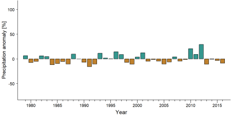
Precipitation anomaly in Kyambura Wildlife Reserve -
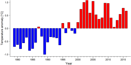
Temperature anomaly in Kyambura Wildlife Reserve


External links
References
Allan, C. (1994). Kyambura Game Reserve, Uganda. Preliminary results of Frontier Uganda Biological Assessment. Frontier, The Society for Environmental Exploration report.
Byaruhanga, A., Kasoma, P., & Pomeroy, D. (2001). Important Bird Areas in Africa and associated islands—Uganda. In Fishpool, L. D., & Evans, M. I. (Eds.), Important Bird Areas in Africa and associated islands: Priority sites for conservation (pp. 975–1003), Cambridge: BirdLife International.
Key Biodiversity Areas Partnership. (2025). Key Biodiversity Areas factsheet: Kyambura Wildlife Reserve. Extracted from the World Database of Key Biodiversity Areas. Developed by the Key Biodiversity Areas Partnership: BirdLife International, IUCN, American Bird Conservancy, Amphibian Survival Alliance, Conservation International, Critical Ecosystem Partnership Fund, Global Environment Facility, Re:wild, NatureServe, Rainforest Trust, Royal Society for the Protection of Birds, World Wildlife Fund, and Wildlife Conservation Society. Downloaded from https://keybiodiversityareas.org/ on March 10, 2025.
Krüger, O., Affeldt, E., Brackmann, M., & Milhahn, K. (1998). Group Size and Composition of Colobus guereza in Kyambura Gorge, Southwest Uganda, in Relation to Chimpanzee Activity. International Journal of Primatology, 19(2), 287-297. doi:10.1023/a:1020383600015
New Vision. (n.d.). Uganda increases power generation with more dams. https://www.newvision.co.ug/news/1513829/uganda-increases-power-generation-dams
Plumptre, A. J., Cox, D., & Mugume, S. (2003). The status of chimpanzees in Uganda. Albertine Rift Technical Report Series No. 2. Wildlife Conservation Society, New York. link
UWA. (2012). Queen Elizabeth National Park, Kyambura Wildlife Reserve and Kigezi Wildlife Reserve: General Management Plan (2011–2021). Kampala, Uganda.
UWA. (2025). Kyambura. https://ugandawildlife.org/wildlifereserves/kyambura/ Retrieved on March 13, 2025.
Volcanoes Safaris. (2025). Kyambura Community Projects, Kyambura Gorge Eco-tourism Project. https://volcanoessafaris.com/kyambura-community-projects/ Retrieved on March 13, 2025.
WCS. (2008). Queen Elizabeth Conservation Area Corridor Action Plan, 2008. Wildlife Conservation Society (WCS), Kampala.
Zwick, K. L., Stubblefield, L., Allan, C., Sivell, D., Lloyd, J., & Cunneyworth, P. (1997). Methods manual. Frontier Protected Areas Project Baseline Surveys Programme, The Society for Environmental Exploration, London & Uganda.
Kiribou, R., Tehoda, P., Chukwu, O., Bempah, G., Kühl, H. S., Ferreira, J., …, & Heinicke, S. (2024). Exposure of African ape sites to climate change impacts. PLOS Climate, 3(2), e0000345. doi:10.1371/journal.pclm.0000345
Page created by: Steven Joel Basiibye Date: 2024-11-20