
Itombwe Nature Reserve: Difference between revisions
No edit summary |
No edit summary Tag: Manual revert |
||
| (9 intermediate revisions by the same user not shown) | |||
| Line 13: | Line 13: | ||
* Key threats to great apes are illegal hunting and logging in connection to illegal mining operations by armed groups. | * Key threats to great apes are illegal hunting and logging in connection to illegal mining operations by armed groups. | ||
* Conservation activities have focused on anti-poaching patrols, monitoring with SMART, and sensitization campaigns. | * Conservation activities have focused on anti-poaching patrols, monitoring with SMART, and sensitization campaigns. | ||
= Site characteristics = | = Site characteristics = | ||
Itombwe Nature Reserve is situated in the southern part of the Maiko-Taina-Kahuzi-Biega landscape in the Democratic Republic of the Congo. The site consists of a large forest block in the Albertine Rift, an important area for great apes. Several peaks of the Itombwe Massif, where the reserve is located, rise above 3,000 m, the highest being Mt. Mohi at 3,475 m (BirdLife International 2020). Itombwe Nature Reserve is also an Endemic Bird Area, an Important Bird Area (563 species have been recorded), an Alliance for Zero Extinction site and a Key Biodiversity Area under the Eastern Afromontane Hotspot (Kujirakwinja et al. 2019). Notably, the Critically Endangered Grauer's gorilla is present at the site. Other mammals of conservation concern present at the site include eastern chimpanzees and forest elephants. At least 21 amphibian taxa have been recorded at the reserve above 1,500 m, most of which have a limited distribution and six are endemic (BirdLife International 2020). | Itombwe Nature Reserve is situated in the southern part of the Maiko-Taina-Kahuzi-Biega landscape in the Democratic Republic of the Congo. The site consists of a large forest block in the Albertine Rift, an important area for great apes. Several peaks of the Itombwe Massif, where the reserve is located, rise above 3,000 m, the highest being Mt. Mohi at 3,475 m ([[#R00774|BirdLife International 2020]]). Itombwe Nature Reserve is also an Endemic Bird Area, an Important Bird Area (563 species have been recorded), an Alliance for Zero Extinction site and a Key Biodiversity Area under the Eastern Afromontane Hotspot ([[#R00775|Kujirakwinja et al. 2019]]). Notably, the Critically Endangered Grauer's gorilla is present at the site. Other mammals of conservation concern present at the site include eastern chimpanzees and forest elephants. At least 21 amphibian taxa have been recorded at the reserve above 1,500 m, most of which have a limited distribution and six are endemic ([[#R00774|BirdLife International 2020]]). | ||
'''Table 1. Basic site information for Itombwe Nature Reserve''' | '''Table 1. Basic site information for Itombwe Nature Reserve''' | ||
| Line 48: | Line 44: | ||
= Ape status = | = Ape status = | ||
In 1996, ICCN and WCS carried out a comprehensive great ape survey, alongside an ornithological study. Findings from these assessments indicated that, over the preceding 25 years, the estimated population of eastern lowland gorillas had declined sharply from nearly 17,000 to approximately 6,800 individuals. This decline was largely attributed to insufficient conservation efforts for these primates. Based on these results, together with recommendations from IUCN in 1992 and 1993, the establishment of the reserve was set in motion and officially realized in 2006 (Ngoy & Kiyengo 2023). | In 1996, ICCN and WCS carried out a comprehensive great ape survey, alongside an ornithological study. Findings from these assessments indicated that, over the preceding 25 years, the estimated population of eastern lowland gorillas had declined sharply from nearly 17,000 to approximately 6,800 individuals. This decline was largely attributed to insufficient conservation efforts for these primates. Based on these results, together with recommendations from IUCN in 1992 and 1993, the establishment of the reserve was set in motion and officially realized in 2006 ([[#R00777|Ngoy & Kiyengo 2023]]). | ||
'''Table 2. Ape population estimates reported for Itombwe Nature Reserve''' | '''Table 2. Ape population estimates reported for Itombwe Nature Reserve''' | ||
| Line 74: | Line 70: | ||
|Reconnaissance walk | |Reconnaissance walk | ||
| | | | ||
|Plumptre et al. 2010 | |[[#R00778|Plumptre et al. 2010]] | ||
| | | | ||
| | | | ||
| Line 83: | Line 79: | ||
= Threats = | = Threats = | ||
Destruction and degradation of the forest followed by large-scale mining has been a key threat at Itombwe. The region has been impacted by armed conflict among refugees who fled the Rwandan genocide in 1994 (Kujirakwinja et al. 2019). Large numbers of people settled and converted the forest for agriculture and pasture land. The discovery of valuable minerals such as coltan and cassiterite exacerbated the situation, as armed groups in the region took control of various parts of the massif and fight for these resources ([https://www.wwf-congobasin.org/where_we_work/democratic_republic_of_congo/itombwe/#:~:text=Despite%20being%20relatively%20isolated%2C%20the,and%20pressure%20from%20human%20populations. WWF]). | Destruction and degradation of the forest followed by large-scale mining has been a key threat at Itombwe. The region has been impacted by armed conflict among refugees who fled the Rwandan genocide in 1994 ([[#R00775|Kujirakwinja et al. 2019]]). Large numbers of people settled and converted the forest for agriculture and pasture land. The discovery of valuable minerals such as coltan and cassiterite exacerbated the situation, as armed groups in the region took control of various parts of the massif and fight for these resources ([https://www.wwf-congobasin.org/where_we_work/democratic_republic_of_congo/itombwe/#:~:text=Despite%20being%20relatively%20isolated%2C%20the,and%20pressure%20from%20human%20populations. WWF]). | ||
'''Table 3. Threats to apes reported for Itombwe Nature Reserve''' | '''Table 3. Threats to apes reported for Itombwe Nature Reserve''' | ||
| Line 92: | Line 88: | ||
!Description | !Description | ||
!Year of threat | !Year of threat | ||
|- | |- | ||
|3 Energy production & mining | |3 Energy production & mining | ||
|3.2 Mining & quarrying | |3.2 Mining & quarrying | ||
|High (more than 70% of population affected) | |High (more than 70% of population affected) | ||
|Mining operations by armed groups (see item 6; [ | |Mining operations by armed groups (see item 6; [[#R02001|WWF]]). | ||
|Ongoing (2021) | |Ongoing (2021) | ||
|- | |- | ||
| Line 114: | Line 98: | ||
|5.1 Hunting & collecting terrestrial animals | |5.1 Hunting & collecting terrestrial animals | ||
|Present (unknown severity) | |Present (unknown severity) | ||
|Bushmeat hunting ([ | |Bushmeat hunting ([[#R02001|WWF]]). | ||
|Ongoing (2021) | |Ongoing (2021) | ||
|- | |- | ||
| Line 120: | Line 104: | ||
|5.3 Logging & wood harvesting | |5.3 Logging & wood harvesting | ||
|Present (unknown severity) | |Present (unknown severity) | ||
|Artisanal logging ([ | |Artisanal logging ([[#R02001|WWF]]). | ||
|Ongoing (2021) | |Ongoing (2021) | ||
|- | |||
|6 Human intrusions & disturbance | |||
|6.2 War, civil unrest & military exercises | |||
|High (more than 70% of population affected) | |||
|Surveys conducted by the WCS during 2003–2006 found increasing threats and the presence of several armed groups controlling various parts of the Itombwe Massif ([[#R00775|Kujirakwinja et al. 2019]]). | |||
|2003-2006 | |||
|- | |||
|12 Other threat | |||
|Other | |||
|High (more than 70% of population affected) | |||
|Habitat fragmentation (Maldonado et al. 2020). | |||
|Ongoing (2020) | |||
|} | |} | ||
| Line 140: | Line 136: | ||
|2 Counter-wildlife crime | |2 Counter-wildlife crime | ||
|2.11 Implement monitoring surveillance strategies (e.g., SMART) or use monitoring data to improve effectiveness of patrols | |2.11 Implement monitoring surveillance strategies (e.g., SMART) or use monitoring data to improve effectiveness of patrols | ||
|Surveys conducted as early as 1996 (Ngoy & Kiyengo 2023). | |Surveys conducted as early as 1996 ([[#R00777|Ngoy & Kiyengo 2023]]). | ||
| | | | ||
|1996-Ongoing (2023) | |1996-Ongoing (2023) | ||
| Line 146: | Line 142: | ||
|2 Counter-wildlife crime | |2 Counter-wildlife crime | ||
|2.3 Conduct regular anti-poaching patrols | |2.3 Conduct regular anti-poaching patrols | ||
|ICCN eco-guards carry out patrols (Ngoy & Kiyengo 2023). | |ICCN eco-guards carry out patrols ([[#R00777|Ngoy & Kiyengo 2023]]). | ||
| | | | ||
|2006-Ongoing (2022) | |2006-Ongoing (2022) | ||
| Line 152: | Line 148: | ||
|4 Education & awareness | |4 Education & awareness | ||
|4.1 Educate local communities about apes and sustainable use | |4.1 Educate local communities about apes and sustainable use | ||
|ICCN teams in collaboration with NGO partners are carrying out sensitization campaigns among the communities to ensure their participation in the conservation of the reserve ([ | |ICCN teams in collaboration with NGO partners are carrying out sensitization campaigns among the communities to ensure their participation in the conservation of the reserve ([[#R02036|Berggorilla & Regenwald]]). | ||
| | | | ||
|Unknown | |Unknown | ||
| Line 164: | Line 160: | ||
|5 Protection & restoration | |5 Protection & restoration | ||
|5.5 Demarcate and enforce boundaries of protected areas | |5.5 Demarcate and enforce boundaries of protected areas | ||
|Demarcation in 2016 through a participatory process (Ngoy & Kiyengo 2023). | |Demarcation in 2016 through a participatory process ([[#R00777|Ngoy & Kiyengo 2023]]). | ||
| | | | ||
|2016 | |2016 | ||
| Line 173: | Line 169: | ||
= Challenges = | = Challenges = | ||
The Minister for the Environment in Kishasa declared that a reserve would be established in Itombwe Massif, and the gazettement of the reserve was written in October 2006. However, no boundaries were delimited in the gazettement document, and this created anger and confusion amongst the communities of the Itombwe Massif, as they had not been consulted about the reserve (Kujirakwinja et al. 2019). Approximately 675,800 people live in or around the Itombwe Reserve (Kujirakwinja et al. 2019). A long process of participatory mapping of the boundaries began in 2010 with Africapacity, Institut Congolais pour la Conservation de la Nature, WCS and WWF staff participating in consultations with each of 550 villages within and around the proposed boundary of the reserve (Kujirakwinja et al. 2019). This process was completed in 2014, and in 2016 the governor of South Kivu signed the official designation of the boundaries of Itombwe Natural Reserve (Kujirakwinja et al. 2019). | The Minister for the Environment in Kishasa declared that a reserve would be established in Itombwe Massif, and the gazettement of the reserve was written in October 2006. However, no boundaries were delimited in the gazettement document, and this created anger and confusion amongst the communities of the Itombwe Massif, as they had not been consulted about the reserve ([[#R00775|Kujirakwinja et al. 2019]]). Approximately 675,800 people live in or around the Itombwe Reserve ([[#R00775|Kujirakwinja et al. 2019]]). A long process of participatory mapping of the boundaries began in 2010 with Africapacity, Institut Congolais pour la Conservation de la Nature, WCS and [[#R02001|WWF]] staff participating in consultations with each of 550 villages within and around the proposed boundary of the reserve ([[#R00775|Kujirakwinja et al. 2019]]). This process was completed in 2014, and in 2016 the governor of South Kivu signed the official designation of the boundaries of Itombwe Natural Reserve ([[#R00775|Kujirakwinja et al. 2019]]). | ||
'''Table 5. Challenges reported for Itombwe Nature Reserve''' | '''Table 5. Challenges reported for Itombwe Nature Reserve''' | ||
| Line 184: | Line 180: | ||
|3 Engaged community | |3 Engaged community | ||
|3.1 General lack of community engagement or support | |3.1 General lack of community engagement or support | ||
|Kujirakwinja et al. 2019 | |[[#R00775|Kujirakwinja et al. 2019]] | ||
| | | | ||
|} | |} | ||
| Line 276: | Line 272: | ||
= Exposure to climate change impacts = | = Exposure to climate change impacts = | ||
As part of a study on the exposure of African great ape sites to climate change impacts, Kiribou et al. | As part of a study on the exposure of African great ape sites to climate change impacts, [[#R02215|Kiribou et al. (2024)]] extracted climate data and data on projected extreme climate impact events for the site. Climatological characteristics were derived from observation-based climate data provided by the Inter-Sectoral Impact Model Intercomparison Project (ISIMIP, www.isimip.org). Parameters were calculated as the average across each 30-year period. For 1981-2010, the EWEMBI dataset from ISIMIP2a was used. For the two future periods (2021-2050 and 2071-2099) ISIMIP2b climate data based on four CMIP5 global climate models were used. For future projections, two Representative Concentration Pathways (RCP) were used. RCP 2.6 is a scenario with strong mitigation measures in which global temperatures would likely rise below 2C. RCP 6.0 is a scenario with medium emissions in which global temperatures would likely rise up to 3C by 2100. For the number of days with heavy precipitation events, the 98th percentile of all precipitation days (>1mm/d) was calculated for the 1979-2013 reference period as a threshold for a heavy precipitation event. Then, for each year, the number of days above that threshold was derived. The figures on temperature and precipitation anomaly show the deviation from the mean temperature and mean precipitation for the 1979-2013 reference period. | ||
The estimated exposure to future extreme climate impact events (crop failure, drought, river flood, wildfire, tropical cyclone, and heatwave) is based on a published dataset by Lange et al. 2020 derived from ISIMIP2b data. The same global climate models and RCPs as described above were used. Within each 30-year period, the number of years with an extreme event and the average proportion of the site affected were calculated ( | The estimated exposure to future extreme climate impact events (crop failure, drought, river flood, wildfire, tropical cyclone, and heatwave) is based on a published dataset by Lange et al. 2020 derived from ISIMIP2b data. The same global climate models and RCPs as described above were used. Within each 30-year period, the number of years with an extreme event and the average proportion of the site affected were calculated ([[#R02215|Kiribou et al. 2024]]). | ||
'''Table 8. Estimated past and projected climatological characteristics in Itombwe Nature Reserve''' | '''Table 8. Estimated past and projected climatological characteristics in Itombwe Nature Reserve''' | ||
| Line 401: | Line 397: | ||
= References = | = References = | ||
BirdLife International (2020) Important Bird Areas factsheet: Itombwe Mountains. Downloaded from http://www.birdlife.org on 30/12/2020. | <span id="R00774"></span>BirdLife International (2020) Important Bird Areas factsheet: Itombwe Mountains. Downloaded from http://www.birdlife.org on 30/12/2020. | ||
<span id="R00775"></span>Kujirakwinja, D., Plumptre, A., Twendilonge, A., Mitamba, G., Mubalama, L., Wasso, J., . . . Tshombe, R. (2019). Establishing the Itombwe Natural Reserve: Science, participatory consultations and zoning. Oryx, 53(1), 49-57. doi:10.1017/S0030605317001478 | |||
<span id="R00776"></span>Maldonado, O., Aveling, C., Cox, D., Nixon, S., Nishuli, R., Merlo, D., Pintea, L. & Williamson, E.A. (2012). Grauer’s Gorillas and Chimpanzees in Eastern Democratic Republic of Congo (Kahuzi-Biega, Maiko, Tayna and Itombwe Landscape): Conservation Action Plan 2012–2022. Gland, Switzerland: IUCN/SSC Primate Specialist Group, Ministry of Environment, Nature Conservation & Tourism, Institut Congolais pour la Conservation de la Nature & the Jane Goodall Institute. 66pp. [http://www.primate-sg.org/storage/pdf/Eastern_DRC_CAP.pdf link] | |||
<span id="R00777"></span>Ngoy, J. B., & Kiyengo, C. S. (2023, June). Erstmals Gorilla in Itombwe fotografiert. Berggorilla & Regenwald Direkthilfe e.V. https://www.berggorilla.org/en/journal/issues/journal-66/article-view/erstmals-gorilla-in-itombwe-fotografiert/ | |||
<span id="R00778"></span>Plumptre, A.J., Rose, R., Nangendo, G., Williamson, E.A., Didier, K., Hart, J., Mulindahabi, F., Hicks, C., Griffin, B., Ogawa, H., Nixon, S., Pintea, L., Vosper, A., McClennan, M., Amsini, F., McNeilage, A., Makana, J.R., Kanamori, M., Hernandez, A., Piel, A., Stewart, F., Moore, J., Zamma, K., Nakamura, M., Kamenya, S., Idani, G., Sakamaki, T., Yoshikawa, M., Greer, D., Tranquilli, S., Beyers, R., Furuichi, T., Hashimoto, C. and Bennett, E. (2010). Eastern Chimpanzee (Pan troglodytes schweinfurthii): Status Survey and Conservation Action Plan 2010–2020. IUCN/SSC Primate Specialist Group, Gland, Switzerland. 52pp. [http://www.primate-sg.org/PDF/ECCAP.pdf link] | |||
<span id="R02126"></span>Kiyengo, C. S. (2023).The Beekeeping Project in Sarambwe Nature Reserve. Volume (66), 8-9. https://www.berggorilla.org/en/gorillas/protected-areas-for-gorillas/protected-areas-for-gorillas/bienenhaltung-rings-um-sarambwe/ | |||
<span id="R02215"></span>Kiribou, R., Tehoda, P., Chukwu, O., Bempah, G., Kühl, H. S., Ferreira, J., …, & Heinicke, S. (2024). Exposure of African ape sites to climate change impacts. ''PLOS Climate'', 3(2), e0000345. [https://doi.org/10.1371/journal.pclm.0000345 doi:10.1371/journal.pclm.0000345] | |||
<span id="R02001"></span>WWF. https://www.wwf-congobasin.org/where_we_work/democratic_republic_of_congo/itombwe/#:~:text=Despite%20being%20relatively%20isolated%2C%20the,and%20pressure%20from%20human%20populations. [https://web.archive.org/web/20220517103910/https://www.wwf-congobasin.org/where_we_work/democratic_republic_of_congo/itombwe/ link] | |||
<span id="R02036"></span>Berggorilla & Regenwald. https://www.berggorilla.org/en/journal/issues/journal-no-51/article-view/the-conservation-of-itombwe-nature-reserve/ [https://web.archive.org/web/20190802171003/https://www.berggorilla.org/en/journal/issues/journal-no-51/article-view/the-conservation-of-itombwe-nature-reserve/ link] | |||
Latest revision as of 17:53, 15 October 2026
Central Africa > Democratic Republic of the Congo > Itombwe Nature Reserve
Français | Português | Español | Bahasa Indonesia | Melayu
Summary
- Eastern chimpanzees (Pan troglodytes schweinfurthii) and Grauer's gorillas (Gorilla beringei graueri) are present in Itombwe Nature Reserve.
- In 2009 the estimated chimpanzee population was approximately 6,302 individuals; the gorilla population size is unknown.
- The great ape population trend is unknown.
- The site has a total size of 6,000 km².
- Key threats to great apes are illegal hunting and logging in connection to illegal mining operations by armed groups.
- Conservation activities have focused on anti-poaching patrols, monitoring with SMART, and sensitization campaigns.
Site characteristics
Itombwe Nature Reserve is situated in the southern part of the Maiko-Taina-Kahuzi-Biega landscape in the Democratic Republic of the Congo. The site consists of a large forest block in the Albertine Rift, an important area for great apes. Several peaks of the Itombwe Massif, where the reserve is located, rise above 3,000 m, the highest being Mt. Mohi at 3,475 m (BirdLife International 2020). Itombwe Nature Reserve is also an Endemic Bird Area, an Important Bird Area (563 species have been recorded), an Alliance for Zero Extinction site and a Key Biodiversity Area under the Eastern Afromontane Hotspot (Kujirakwinja et al. 2019). Notably, the Critically Endangered Grauer's gorilla is present at the site. Other mammals of conservation concern present at the site include eastern chimpanzees and forest elephants. At least 21 amphibian taxa have been recorded at the reserve above 1,500 m, most of which have a limited distribution and six are endemic (BirdLife International 2020).
Table 1. Basic site information for Itombwe Nature Reserve
| Species | Pan troglodytes schweinfurthii |
| Area | 6,000 km² |
| Coordinates | Lat: -3.672696 , Lon: 28.136638 |
| Type of site | Protected area (Nature Reserve) |
| Habitat types | Subtropical/tropical moist montane forest |
| Type of governance |
Types of sites Governance types Habitat types
Ape status
In 1996, ICCN and WCS carried out a comprehensive great ape survey, alongside an ornithological study. Findings from these assessments indicated that, over the preceding 25 years, the estimated population of eastern lowland gorillas had declined sharply from nearly 17,000 to approximately 6,800 individuals. This decline was largely attributed to insufficient conservation efforts for these primates. Based on these results, together with recommendations from IUCN in 1992 and 1993, the establishment of the reserve was set in motion and officially realized in 2006 (Ngoy & Kiyengo 2023).
Table 2. Ape population estimates reported for Itombwe Nature Reserve
| Species | Year | Occurrence | Encounter or vistation rate (nests/km; ind/day) | Density estimate [ind./ km²] (95% CI) | Abundance estimate (95% CI) | Survey area | Sampling method | Analytical framework | Source | Comments | A.P.E.S. database ID |
|---|---|---|---|---|---|---|---|---|---|---|---|
| Pan troglodytes schweinfurthii | 2009 | 0.63 | 6302.0 | Itombwe Massif (10,000 km²) | Reconnaissance walk | Plumptre et al. 2010 |
Sampling methods Analytical frameworks
Threats
Destruction and degradation of the forest followed by large-scale mining has been a key threat at Itombwe. The region has been impacted by armed conflict among refugees who fled the Rwandan genocide in 1994 (Kujirakwinja et al. 2019). Large numbers of people settled and converted the forest for agriculture and pasture land. The discovery of valuable minerals such as coltan and cassiterite exacerbated the situation, as armed groups in the region took control of various parts of the massif and fight for these resources (WWF).
Table 3. Threats to apes reported for Itombwe Nature Reserve
| Category | Specific threats | Threat level | Description | Year of threat |
|---|---|---|---|---|
| 3 Energy production & mining | 3.2 Mining & quarrying | High (more than 70% of population affected) | Mining operations by armed groups (see item 6; WWF). | Ongoing (2021) |
| 5 Biological resource use | 5.1 Hunting & collecting terrestrial animals | Present (unknown severity) | Bushmeat hunting (WWF). | Ongoing (2021) |
| 5 Biological resource use | 5.3 Logging & wood harvesting | Present (unknown severity) | Artisanal logging (WWF). | Ongoing (2021) |
| 6 Human intrusions & disturbance | 6.2 War, civil unrest & military exercises | High (more than 70% of population affected) | Surveys conducted by the WCS during 2003–2006 found increasing threats and the presence of several armed groups controlling various parts of the Itombwe Massif (Kujirakwinja et al. 2019). | 2003-2006 |
| 12 Other threat | Other | High (more than 70% of population affected) | Habitat fragmentation (Maldonado et al. 2020). | Ongoing (2020) |
Conservation activities
Table 4. Conservation activities reported for Itombwe Nature Reserve
| Category | Specific activity | Description | Implementing organization(s) | Year of activity |
|---|---|---|---|---|
| 2 Counter-wildlife crime | 2.11 Implement monitoring surveillance strategies (e.g., SMART) or use monitoring data to improve effectiveness of patrols | Surveys conducted as early as 1996 (Ngoy & Kiyengo 2023). | 1996-Ongoing (2023) | |
| 2 Counter-wildlife crime | 2.3 Conduct regular anti-poaching patrols | ICCN eco-guards carry out patrols (Ngoy & Kiyengo 2023). | 2006-Ongoing (2022) | |
| 4 Education & awareness | 4.1 Educate local communities about apes and sustainable use | ICCN teams in collaboration with NGO partners are carrying out sensitization campaigns among the communities to ensure their participation in the conservation of the reserve (Berggorilla & Regenwald). | Unknown | |
| 5 Protection & restoration | 5.2 Legally protect ape habitat | The site is designated as a Nature Reserve. | 2006-Ongoing (2026) | |
| 5 Protection & restoration | 5.5 Demarcate and enforce boundaries of protected areas | Demarcation in 2016 through a participatory process (Ngoy & Kiyengo 2023). | 2016 |
Challenges
The Minister for the Environment in Kishasa declared that a reserve would be established in Itombwe Massif, and the gazettement of the reserve was written in October 2006. However, no boundaries were delimited in the gazettement document, and this created anger and confusion amongst the communities of the Itombwe Massif, as they had not been consulted about the reserve (Kujirakwinja et al. 2019). Approximately 675,800 people live in or around the Itombwe Reserve (Kujirakwinja et al. 2019). A long process of participatory mapping of the boundaries began in 2010 with Africapacity, Institut Congolais pour la Conservation de la Nature, WCS and WWF staff participating in consultations with each of 550 villages within and around the proposed boundary of the reserve (Kujirakwinja et al. 2019). This process was completed in 2014, and in 2016 the governor of South Kivu signed the official designation of the boundaries of Itombwe Natural Reserve (Kujirakwinja et al. 2019).
Table 5. Challenges reported for Itombwe Nature Reserve
| Challenges | Specific challenges | Source | Year(s) |
|---|---|---|---|
| 3 Engaged community | 3.1 General lack of community engagement or support | Kujirakwinja et al. 2019 |
Enablers
Table 6. Enablers reported for Itombwe Nature Reserve
| Enablers | Specific enablers | Source | Year(s) |
|---|---|---|---|
| 1 Site management | |||
| 2 Resources and capacity | |||
| 3 Engaged community | |||
| 4 Institutional support | |||
| 5 Ecological context | |||
| 6 Safety and stability |
Research activities
Plumptre, A.J., Kujirakwinja, D., Ayebare, S., Mitamba, G., Muhindo, E., & Twendilonge, A. (2013). Plan de Zonage de la Réserve Naturelle d'Itombwe.Unpublished Report to Wildlife Conservation Society.
Cows and guns. Cattle-related conflict and armed violence in Fizi and Itombwe, eastern DR Congo
Documented behaviours
Table 7. Behaviours documented for Itombwe Nature Reserve
| Category | Behavior | Observation type | Prevalence | Observation dates | Source | Habituation | Species | Comment |
|---|---|---|---|---|---|---|---|---|
| Not reported |
Exposure to climate change impacts
As part of a study on the exposure of African great ape sites to climate change impacts, Kiribou et al. (2024) extracted climate data and data on projected extreme climate impact events for the site. Climatological characteristics were derived from observation-based climate data provided by the Inter-Sectoral Impact Model Intercomparison Project (ISIMIP, www.isimip.org). Parameters were calculated as the average across each 30-year period. For 1981-2010, the EWEMBI dataset from ISIMIP2a was used. For the two future periods (2021-2050 and 2071-2099) ISIMIP2b climate data based on four CMIP5 global climate models were used. For future projections, two Representative Concentration Pathways (RCP) were used. RCP 2.6 is a scenario with strong mitigation measures in which global temperatures would likely rise below 2C. RCP 6.0 is a scenario with medium emissions in which global temperatures would likely rise up to 3C by 2100. For the number of days with heavy precipitation events, the 98th percentile of all precipitation days (>1mm/d) was calculated for the 1979-2013 reference period as a threshold for a heavy precipitation event. Then, for each year, the number of days above that threshold was derived. The figures on temperature and precipitation anomaly show the deviation from the mean temperature and mean precipitation for the 1979-2013 reference period.
The estimated exposure to future extreme climate impact events (crop failure, drought, river flood, wildfire, tropical cyclone, and heatwave) is based on a published dataset by Lange et al. 2020 derived from ISIMIP2b data. The same global climate models and RCPs as described above were used. Within each 30-year period, the number of years with an extreme event and the average proportion of the site affected were calculated (Kiribou et al. 2024).
Table 8. Estimated past and projected climatological characteristics in Itombwe Nature Reserve
| Value | 1981-2010 | 2021-2050, RCP 2.6 | 2021-2050, RCP 6.0 | 2071-2099, RCP 2.6 | 2071-2099, RCP 6.0 |
|---|---|---|---|---|---|
| Mean temperature [C] | 18.7 | 19.9 | 19.6 | 20 | 21.2 |
| Annual precipitation [mm] | 1067 | 1068 | 1106 | 1076 | 1101 |
| Max no. consecutive dry days (per year) | 49.5 | 57.7 | 53.2 | 63 | 55.5 |
| No. days with heavy precipitation (per year) | 5.9 | 6.4 | 6.7 | 6.8 | 8.7 |
Table 9. Projected exposure of apes to extreme climate impact events in Itombwe Nature Reserve
| Type | No. of years with event (2021-2050, RCP 2.6) | % of site exposed (2021-2050, RCP 2.6) | No. of years with event (2021-2050, RCP 6.0) | % of site exposed (2021-2050, RCP 6.0) | No. of years with event (2070-2099, RCP 2.6) | % of site exposed (2070-2099, RCP 2.6) | No. of years with event (2070-2099, RCP 6.0) | % of site exposed (2070-2099, RCP 6.0) |
|---|---|---|---|---|---|---|---|---|
| Crop failure | 7 | 0.19 | 4.5 | 0.14 | 10.5 | 0.2 | 12 | 0.14 |
| Drought | 0 | 0 | 0 | 0 | 0 | 0 | 0 | 0 |
| Heatwave | 0 | 0 | 0 | 0 | 0 | 0 | 0 | 0 |
| River flood | 1.5 | 0.41 | 3.75 | 0.71 | 1.5 | 0.51 | 3.5 | 0.45 |
| Tropical cyclone | 0 | 0 | 0 | 0 | 0 | 0 | 0 | 0 |
| Wildfire | 30 | 1.46 | 30 | 1.38 | 29 | 1.51 | 29 | 1.31 |
-
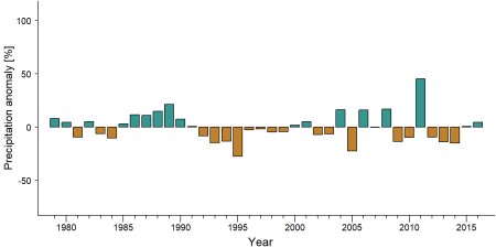
Precipitation anomaly in Itombwe Nature Reserve -
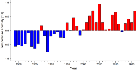
Temperature anomaly in Itombwe Nature Reserve


External links
References
BirdLife International (2020) Important Bird Areas factsheet: Itombwe Mountains. Downloaded from http://www.birdlife.org on 30/12/2020.
Kujirakwinja, D., Plumptre, A., Twendilonge, A., Mitamba, G., Mubalama, L., Wasso, J., . . . Tshombe, R. (2019). Establishing the Itombwe Natural Reserve: Science, participatory consultations and zoning. Oryx, 53(1), 49-57. doi:10.1017/S0030605317001478
Maldonado, O., Aveling, C., Cox, D., Nixon, S., Nishuli, R., Merlo, D., Pintea, L. & Williamson, E.A. (2012). Grauer’s Gorillas and Chimpanzees in Eastern Democratic Republic of Congo (Kahuzi-Biega, Maiko, Tayna and Itombwe Landscape): Conservation Action Plan 2012–2022. Gland, Switzerland: IUCN/SSC Primate Specialist Group, Ministry of Environment, Nature Conservation & Tourism, Institut Congolais pour la Conservation de la Nature & the Jane Goodall Institute. 66pp. link
Ngoy, J. B., & Kiyengo, C. S. (2023, June). Erstmals Gorilla in Itombwe fotografiert. Berggorilla & Regenwald Direkthilfe e.V. https://www.berggorilla.org/en/journal/issues/journal-66/article-view/erstmals-gorilla-in-itombwe-fotografiert/
Plumptre, A.J., Rose, R., Nangendo, G., Williamson, E.A., Didier, K., Hart, J., Mulindahabi, F., Hicks, C., Griffin, B., Ogawa, H., Nixon, S., Pintea, L., Vosper, A., McClennan, M., Amsini, F., McNeilage, A., Makana, J.R., Kanamori, M., Hernandez, A., Piel, A., Stewart, F., Moore, J., Zamma, K., Nakamura, M., Kamenya, S., Idani, G., Sakamaki, T., Yoshikawa, M., Greer, D., Tranquilli, S., Beyers, R., Furuichi, T., Hashimoto, C. and Bennett, E. (2010). Eastern Chimpanzee (Pan troglodytes schweinfurthii): Status Survey and Conservation Action Plan 2010–2020. IUCN/SSC Primate Specialist Group, Gland, Switzerland. 52pp. link
Kiyengo, C. S. (2023).The Beekeeping Project in Sarambwe Nature Reserve. Volume (66), 8-9. https://www.berggorilla.org/en/gorillas/protected-areas-for-gorillas/protected-areas-for-gorillas/bienenhaltung-rings-um-sarambwe/
Kiribou, R., Tehoda, P., Chukwu, O., Bempah, G., Kühl, H. S., Ferreira, J., …, & Heinicke, S. (2024). Exposure of African ape sites to climate change impacts. PLOS Climate, 3(2), e0000345. doi:10.1371/journal.pclm.0000345
WWF. https://www.wwf-congobasin.org/where_we_work/democratic_republic_of_congo/itombwe/#:~:text=Despite%20being%20relatively%20isolated%2C%20the,and%20pressure%20from%20human%20populations. link
Berggorilla & Regenwald. https://www.berggorilla.org/en/journal/issues/journal-no-51/article-view/the-conservation-of-itombwe-nature-reserve/ link
Page created by: APES Atlas Team Date: 2021-01-08
Page updated by: APES Atlas Team Date: 2025-10-01