
Ngotto Forest: Difference between revisions
No edit summary |
No edit summary Tag: Manual revert |
||
| (3 intermediate revisions by the same user not shown) | |||
| Line 17: | Line 17: | ||
= Site characteristics = | = Site characteristics = | ||
Located at the northern edge of the Congo Forest Basin, Ngotto is of particular interest due to its intersection with the northern savannah ecosystem. Until recently, it remained one of the last extensive tracts of natural forest in the southwestern Central African Republic (Hicks et al. 2009). The Ngotto forest complex, covering 780,000 hectares, includes the Mbaéré-Bodingué National Park (80,000 ha) and adjacent forest concessions. This critical ecosystem lies at the transition between savanna and tropical forest biomes and supports endangered species such as elephants, gorillas, and chimpanzees. | Located at the northern edge of the Congo Forest Basin, Ngotto is of particular interest due to its intersection with the northern savannah ecosystem. Until recently, it remained one of the last extensive tracts of natural forest in the southwestern Central African Republic ([[#R01361|Hicks et al. 2009]]). The Ngotto forest complex, covering 780,000 hectares, includes the Mbaéré-Bodingué National Park (80,000 ha) and adjacent forest concessions. This critical ecosystem lies at the transition between savanna and tropical forest biomes and supports endangered species such as elephants, gorillas, and chimpanzees. | ||
Since the end of the ECOFAC project, this biodiversity has come under increasing pressure. A recent inventory of wildlife and flora was conducted to relaunch conservation efforts in the park and surrounding areas. The study confirmed the presence of 27 mammal species and 323 woody plant species. It also identified three key wildlife-rich zones, relatively undisturbed due to natural isolation, which serve as biodiversity refuges. The estimated population of gorillas and chimpanzees was 931 individuals, reflecting a density decline of approximately 70% since the late 1990s. Among the woody species, six were classified as Vulnerable and eight as Endangered by the IUCN. | Since the end of the ECOFAC project, this biodiversity has come under increasing pressure. A recent inventory of wildlife and flora was conducted to relaunch conservation efforts in the park and surrounding areas. The study confirmed the presence of 27 mammal species and 323 woody plant species. It also identified three key wildlife-rich zones, relatively undisturbed due to natural isolation, which serve as biodiversity refuges. The estimated population of gorillas and chimpanzees was 931 individuals, reflecting a density decline of approximately 70% since the late 1990s. Among the woody species, six were classified as Vulnerable and eight as Endangered by the IUCN. | ||
Human activities ranging from sustainable traditional practices to harmful ones such as slash-and-burn agriculture, commercial hunting, and logging continue to threaten biodiversity. The inventory provides a baseline for monitoring future conservation efforts and underscores the urgent need for strategic action to prevent further biodiversity loss (N'Goran et al. 2024). | Human activities ranging from sustainable traditional practices to harmful ones such as slash-and-burn agriculture, commercial hunting, and logging continue to threaten biodiversity. The inventory provides a baseline for monitoring future conservation efforts and underscores the urgent need for strategic action to prevent further biodiversity loss ([[#R01363|N'Goran et al. 2024]]). | ||
'''Table 1. Basic site information for Ngotto Forest''' | '''Table 1. Basic site information for Ngotto Forest''' | ||
| Line 46: | Line 46: | ||
= Ape status = | = Ape status = | ||
A total of 0.32 great ape nests per kilometer were found in the logged section of the forest, compared with 3.52 nests per kilometer in the immediately adjacent unlogged but transected forest, 11 times the difference (Hicks et al. 2009). | A total of 0.32 great ape nests per kilometer were found in the logged section of the forest, compared with 3.52 nests per kilometer in the immediately adjacent unlogged but transected forest, 11 times the difference ([[#R01361|Hicks et al. 2009]]). | ||
'''Table 2. Ape population estimates reported for Ngotto Forest''' | '''Table 2. Ape population estimates reported for Ngotto Forest''' | ||
| Line 72: | Line 72: | ||
|Line transects & recces, Camera trap | |Line transects & recces, Camera trap | ||
|Distance sampling | |Distance sampling | ||
|N'Goran et al. 2024 | |[[#R01363|N'Goran et al. 2024]] | ||
| | | | ||
| | | | ||
| Line 85: | Line 85: | ||
|Line transects | |Line transects | ||
| | | | ||
|Hicks et al. 2009 | |[[#R01361|Hicks et al. 2009]] | ||
| | | | ||
| | | | ||
| Line 98: | Line 98: | ||
|Line transects | |Line transects | ||
| | | | ||
|Hicks et al. 2009 | |[[#R01361|Hicks et al. 2009]] | ||
| | | | ||
| | | | ||
| Line 107: | Line 107: | ||
= Threats = | = Threats = | ||
The timber company Industrie Forestiére du Batalimo (IFB) has been selectively exploiting the Ngotto Forest, concession PEA 169, since the late 90s. Surveyors for the logging company lived for weeks in the forest in makeshift camps. Hunters associated with the logging company regularly hunted using wire snares, shotguns, and flashlights for night hunting.T. C. Hicks observed logging trucks on nearby roads transporting large sacks of bushmeat, likely destined for sale in urban areas (Hicks et al. 2009). | The timber company Industrie Forestiére du Batalimo (IFB) has been selectively exploiting the Ngotto Forest, concession PEA 169, since the late 90s. Surveyors for the logging company lived for weeks in the forest in makeshift camps. Hunters associated with the logging company regularly hunted using wire snares, shotguns, and flashlights for night hunting.T. C. Hicks observed logging trucks on nearby roads transporting large sacks of bushmeat, likely destined for sale in urban areas ([[#R01361|Hicks et al. 2009]]). | ||
'''Table 3. Threats to apes reported for Ngotto Forest''' | '''Table 3. Threats to apes reported for Ngotto Forest''' | ||
| Line 120: | Line 120: | ||
|2.1 Annual & perennial non-timber crops | |2.1 Annual & perennial non-timber crops | ||
|Present (unknown severity) | |Present (unknown severity) | ||
|Agricultural expansion, shifting cultivation, and plantations were reported among the main threats, as they destroy habitats and impoverish soils (N'Goran et al. 2024). | |Agricultural expansion, shifting cultivation, and plantations were reported among the main threats, as they destroy habitats and impoverish soils ([[#R01363|N'Goran et al. 2024]]). | ||
|Ongoing (2024) | |Ongoing (2024) | ||
|- | |- | ||
| Line 126: | Line 126: | ||
|5.1 Hunting & collecting terrestrial animals | |5.1 Hunting & collecting terrestrial animals | ||
|High (more than 70% of population affected) | |High (more than 70% of population affected) | ||
|Bushmeat hunting linked to the presence of loggers (Hicks et al. 2009, N'Goran et al. 2024). | |Bushmeat hunting linked to the presence of loggers ([[#R01361|Hicks et al. 2009]], [[#R01363|N'Goran et al. 2024]]). | ||
|2009-Ongoing (2024) | |2009-Ongoing (2024) | ||
|- | |- | ||
| Line 132: | Line 132: | ||
|5.2 Gathering terrestrial plants | |5.2 Gathering terrestrial plants | ||
|Present (unknown severity) | |Present (unknown severity) | ||
|The collection of mushrooms and other forest products was also reported (N'Goran et al. 2024). | |The collection of mushrooms and other forest products was also reported ([[#R01363|N'Goran et al. 2024]]). | ||
|Ongoing (2024) | |Ongoing (2024) | ||
|- | |- | ||
| Line 138: | Line 138: | ||
|5.3 Logging & wood harvesting | |5.3 Logging & wood harvesting | ||
|High (more than 70% of population affected) | |High (more than 70% of population affected) | ||
|Parts of the forest are, or have been, logging concessions (Hicks et al. 2009, N'Goran et al. 2024). | |Parts of the forest are, or have been, logging concessions ([[#R01361|Hicks et al. 2009]], [[#R01363|N'Goran et al. 2024]]). | ||
|2009-Ongoing (2024) | |2009-Ongoing (2024) | ||
|- | |- | ||
| Line 144: | Line 144: | ||
|7.1 Fire & fire suppression | |7.1 Fire & fire suppression | ||
|Present (unknown severity) | |Present (unknown severity) | ||
|Uncontrollable bushfires and slash-and-burn agriculture were also reported among the main threats (N'Goran et al. 2024). | |Uncontrollable bushfires and slash-and-burn agriculture were also reported among the main threats ([[#R01363|N'Goran et al. 2024]]). | ||
|Ongoing (2024) | |Ongoing (2024) | ||
|} | |} | ||
| Line 164: | Line 164: | ||
|2 Counter-wildlife crime | |2 Counter-wildlife crime | ||
|2.11 Implement monitoring surveillance strategies (e.g., SMART) or use monitoring data to improve effectiveness of patrols | |2.11 Implement monitoring surveillance strategies (e.g., SMART) or use monitoring data to improve effectiveness of patrols | ||
|The inventory and ecological monitoring were conducted to establish baselines that strengthen surveillance and support future impact assessments. This was initiated as part of the GEF Phase 7 Program, supported by the World Bank, with WWF (N'Goran et al. 2024). | |The inventory and ecological monitoring were conducted to establish baselines that strengthen surveillance and support future impact assessments. This was initiated as part of the GEF Phase 7 Program, supported by the World Bank, with WWF ([[#R01363|N'Goran et al. 2024]]). | ||
|Fonds pour l’Environnement Mondial (GEF), the World Bank, and WWF | |Fonds pour l’Environnement Mondial (GEF), the World Bank, and WWF | ||
|Ongoing (2024) | |Ongoing (2024) | ||
| Line 184: | Line 184: | ||
|2 Resources and capacity | |2 Resources and capacity | ||
|2.6 Lack of biomonitoring/survey data | |2.6 Lack of biomonitoring/survey data | ||
|N'Goran et al. 2024 | |[[#R01363|N'Goran et al. 2024]] | ||
|Ongoing (2024) | |Ongoing (2024) | ||
|- | |- | ||
|4 Institutional support | |4 Institutional support | ||
|4.1 Lack of law enforcement | |4.1 Lack of law enforcement | ||
|Hicks et al. 2009, N'Goran et al. 2024 | |[[#R01361|Hicks et al. 2009]], [[#R01363|N'Goran et al. 2024]] | ||
|2009-Ongoing (2024) | |2009-Ongoing (2024) | ||
|- | |- | ||
|4 Institutional support | |4 Institutional support | ||
|4.3 Lack of protected area status | |4.3 Lack of protected area status | ||
|N'Goran et al. 2024 | |[[#R01363|N'Goran et al. 2024]] | ||
|Ongoing (2024) | |Ongoing (2024) | ||
|} | |} | ||
| Line 213: | Line 213: | ||
|2 Resources and capacity | |2 Resources and capacity | ||
|2.6 External partnerships that add expertise or resources | |2.6 External partnerships that add expertise or resources | ||
|N'Goran et al. 2024 | |[[#R01363|N'Goran et al. 2024]] | ||
|Ongoing (2024) | |Ongoing (2024) | ||
|- | |- | ||
| Line 270: | Line 270: | ||
| | | | ||
| | | | ||
|Hicks, Fouts & Fouts 2005 | |[[#R01362|Hicks, Fouts & Fouts 2005]] | ||
| | | | ||
| | | | ||
| Line 280: | Line 280: | ||
| | | | ||
| | | | ||
|Hicks, Fouts & Fouts 2005 | |[[#R01362|Hicks, Fouts & Fouts 2005]] | ||
| | | | ||
| | | | ||
| Line 290: | Line 290: | ||
= Exposure to climate change impacts = | = Exposure to climate change impacts = | ||
As part of a study on the exposure of African great ape sites to climate change impacts, Kiribou et al. | As part of a study on the exposure of African great ape sites to climate change impacts, [[#R02280|Kiribou et al. (2024)]] extracted climate data and data on projected extreme climate impact events for the site. Climatological characteristics were derived from observation-based climate data provided by the Inter-Sectoral Impact Model Intercomparison Project (ISIMIP, www.isimip.org). Parameters were calculated as the average across each 30-year period. For 1981-2010, the EWEMBI dataset from ISIMIP2a was used. For the two future periods (2021-2050 and 2071-2099) ISIMIP2b climate data based on four CMIP5 global climate models were used. For future projections, two Representative Concentration Pathways (RCP) were used. RCP 2.6 is a scenario with strong mitigation measures in which global temperatures would likely rise below 2C. RCP 6.0 is a scenario with medium emissions in which global temperatures would likely rise up to 3C by 2100. For the number of days with heavy precipitation events, the 98th percentile of all precipitation days (>1mm/d) was calculated for the 1979-2013 reference period as a threshold for a heavy precipitation event. Then, for each year, the number of days above that threshold was derived. The figures on temperature and precipitation anomaly show the deviation from the mean temperature and mean precipitation for the 1979-2013 reference period. | ||
The estimated exposure to future extreme climate impact events (crop failure, drought, river flood, wildfire, tropical cyclone, and heatwave) is based on a published dataset by Lange et al. 2020 derived from ISIMIP2b data. The same global climate models and RCPs as described above were used. Within each 30-year period, the number of years with an extreme event and the average proportion of the site affected were calculated ( | The estimated exposure to future extreme climate impact events (crop failure, drought, river flood, wildfire, tropical cyclone, and heatwave) is based on a published dataset by Lange et al. 2020 derived from ISIMIP2b data. The same global climate models and RCPs as described above were used. Within each 30-year period, the number of years with an extreme event and the average proportion of the site affected were calculated ([[#R02280|Kiribou et al. 2024]]). | ||
'''Table 8. Estimated past and projected climatological characteristics in Ngotto Forest''' | '''Table 8. Estimated past and projected climatological characteristics in Ngotto Forest''' | ||
| Line 415: | Line 415: | ||
= References = | = References = | ||
Hicks, T.C., Fouts, R.S. & Fouts, D.H.(2009). A Survey of Chimpanzees (Pan troglodytes troglodytes) and Gorillas (Gorilla gorilla gorilla) in the Selectively Logged Ngotto Forest, Central African Republic. Journal of Applied Animal Welfare Science,12(3),165-188. | <span id="R01361"></span>Hicks, T. C., Fouts, R. S., & Fouts, D. H. (2009). A Survey of Chimpanzees (Pan troglodytes troglodytes) and Gorillas (Gorilla gorilla gorilla) in the Selectively Logged Ngotto Forest, Central African Republic. ''Journal of Applied Animal Welfare Science'', 12(3), 165-188. [https://doi.org/10.1080/10888700902955872 doi:10.1080/10888700902955872] | ||
Hicks, T.C., Fouts R.S. & Fouts, D.H. (2005). Chimpanzee (Pan troglodytes troglodytes) | <span id="R01362"></span>Hicks, T. C., Fouts, R. S., & Fouts, D. H. (2005). Chimpanzee (Pan troglodytes troglodytes) tool use in the Ngotto Forest, Central African Republic. ''American Journal of Primatology'', 65(3), 221-237. [https://doi.org/10.1002/ajp.20111 doi:10.1002/ajp.20111] | ||
N'Goran, K. P., Beukou Choumbou, G. B., Ndotar, A., & Deguene, B. (2024). Inventaire de faune et de flore dans la forêt de Ngotto (Parc National Mbaéré Bodingué et sa périphérie). WWF/Bureau Régional pour l'Afrique/ Bureau du Cameroun/ Congo Basin Impact Monitoring Programme & WWF/Bureau de la République Centrafricaine. | <span id="R01363"></span>N'Goran, K. P., Beukou Choumbou, G. B., Ndotar, A., & Deguene, B. (2024). Inventaire de faune et de flore dans la forêt de Ngotto (Parc National Mbaéré Bodingué et sa périphérie). WWF/Bureau Régional pour l'Afrique/ Bureau du Cameroun/ Congo Basin Impact Monitoring Programme & WWF/Bureau de la République Centrafricaine. | ||
<span id="R02280"></span>Kiribou, R., Tehoda, P., Chukwu, O., Bempah, G., Kühl, H. S., Ferreira, J., …, & Heinicke, S. (2024). Exposure of African ape sites to climate change impacts. ''PLOS Climate'', 3(2), e0000345. [https://doi.org/10.1371/journal.pclm.0000345 doi:10.1371/journal.pclm.0000345] | |||
'''Page created by: '''APES Atlas Team''' Date:''' 2021-01-08 | '''Page created by: '''APES Atlas Team''' Date:''' 2021-01-08 | ||
Latest revision as of 17:54, 15 October 2026
Central Africa > Central African Republic > Ngotto Forest
Français | Português | Español | Bahasa Indonesia | Melayu
Summary
- The main conservation activities is inventory and ecological monitoring.
- The population size is estimated to be around 931 individuals (Western lowland gorillas and Central chimpanzees).
- The population density of great apes has declined by approximately 70% since the late 1990s.
- The site has a total size of 7,800 km².
- Key threats to chimpanzees are hunting and logging.
- The main conservation activities include regular patrols, awareness raising, and monetary benefits.
Site characteristics
Located at the northern edge of the Congo Forest Basin, Ngotto is of particular interest due to its intersection with the northern savannah ecosystem. Until recently, it remained one of the last extensive tracts of natural forest in the southwestern Central African Republic (Hicks et al. 2009). The Ngotto forest complex, covering 780,000 hectares, includes the Mbaéré-Bodingué National Park (80,000 ha) and adjacent forest concessions. This critical ecosystem lies at the transition between savanna and tropical forest biomes and supports endangered species such as elephants, gorillas, and chimpanzees. Since the end of the ECOFAC project, this biodiversity has come under increasing pressure. A recent inventory of wildlife and flora was conducted to relaunch conservation efforts in the park and surrounding areas. The study confirmed the presence of 27 mammal species and 323 woody plant species. It also identified three key wildlife-rich zones, relatively undisturbed due to natural isolation, which serve as biodiversity refuges. The estimated population of gorillas and chimpanzees was 931 individuals, reflecting a density decline of approximately 70% since the late 1990s. Among the woody species, six were classified as Vulnerable and eight as Endangered by the IUCN. Human activities ranging from sustainable traditional practices to harmful ones such as slash-and-burn agriculture, commercial hunting, and logging continue to threaten biodiversity. The inventory provides a baseline for monitoring future conservation efforts and underscores the urgent need for strategic action to prevent further biodiversity loss (N'Goran et al. 2024).
Table 1. Basic site information for Ngotto Forest
| Species | Pan troglodytes troglodytes, Gorilla gorilla gorilla |
| Area | 7,800 km² |
| Coordinates | Lat: 3.889943 , Lon: 17.315173 |
| Type of site | Non-protected area |
| Habitat types | Subtropical/tropical moist lowland forest, Subtropical/tropical dry forest |
| Type of governance | Governance by government |
Types of sites Governance types Habitat types
Ape status
A total of 0.32 great ape nests per kilometer were found in the logged section of the forest, compared with 3.52 nests per kilometer in the immediately adjacent unlogged but transected forest, 11 times the difference (Hicks et al. 2009).
Table 2. Ape population estimates reported for Ngotto Forest
| Species | Year | Occurrence | Encounter or vistation rate (nests/km; ind/day) | Density estimate [ind./ km²] (95% CI) | Abundance estimate (95% CI) | Survey area | Sampling method | Analytical framework | Source | Comments | A.P.E.S. database ID |
|---|---|---|---|---|---|---|---|---|---|---|---|
| 'Gorilla gorilla gorilla & Pan troglodytes troglodytes | 2024 | Present | 931 (357-2427) | Ngotto Forest Complex, National Park and adjacent forest concessions | Line transects & recces, Camera trap | Distance sampling | N'Goran et al. 2024 | ||||
| Pan troglodytes troglodytes | 2001-2002 | 0.40 | Ngotto Forest | Line transects | Hicks et al. 2009 | ||||||
| Gorilla gorilla gorilla | 2001-2002 | 0.49 | Ngotto Forest | Line transects | Hicks et al. 2009 |
Sampling methods Analytical frameworks
Threats
The timber company Industrie Forestiére du Batalimo (IFB) has been selectively exploiting the Ngotto Forest, concession PEA 169, since the late 90s. Surveyors for the logging company lived for weeks in the forest in makeshift camps. Hunters associated with the logging company regularly hunted using wire snares, shotguns, and flashlights for night hunting.T. C. Hicks observed logging trucks on nearby roads transporting large sacks of bushmeat, likely destined for sale in urban areas (Hicks et al. 2009).
Table 3. Threats to apes reported for Ngotto Forest
| Category | Specific threats | Threat level | Description | Year of threat |
|---|---|---|---|---|
| 2 Agriculture & aquaculture | 2.1 Annual & perennial non-timber crops | Present (unknown severity) | Agricultural expansion, shifting cultivation, and plantations were reported among the main threats, as they destroy habitats and impoverish soils (N'Goran et al. 2024). | Ongoing (2024) |
| 5 Biological resource use | 5.1 Hunting & collecting terrestrial animals | High (more than 70% of population affected) | Bushmeat hunting linked to the presence of loggers (Hicks et al. 2009, N'Goran et al. 2024). | 2009-Ongoing (2024) |
| 5 Biological resource use | 5.2 Gathering terrestrial plants | Present (unknown severity) | The collection of mushrooms and other forest products was also reported (N'Goran et al. 2024). | Ongoing (2024) |
| 5 Biological resource use | 5.3 Logging & wood harvesting | High (more than 70% of population affected) | Parts of the forest are, or have been, logging concessions (Hicks et al. 2009, N'Goran et al. 2024). | 2009-Ongoing (2024) |
| 7 Natural system modifications | 7.1 Fire & fire suppression | Present (unknown severity) | Uncontrollable bushfires and slash-and-burn agriculture were also reported among the main threats (N'Goran et al. 2024). | Ongoing (2024) |
Conservation activities
Table 4. Conservation activities reported for Ngotto Forest
| Category | Specific activity | Description | Implementing organization(s) | Year of activity |
|---|---|---|---|---|
| 2 Counter-wildlife crime | 2.11 Implement monitoring surveillance strategies (e.g., SMART) or use monitoring data to improve effectiveness of patrols | The inventory and ecological monitoring were conducted to establish baselines that strengthen surveillance and support future impact assessments. This was initiated as part of the GEF Phase 7 Program, supported by the World Bank, with WWF (N'Goran et al. 2024). | Fonds pour l’Environnement Mondial (GEF), the World Bank, and WWF | Ongoing (2024) |
Challenges
Table 5. Challenges reported for Ngotto Forest
| Challenges | Specific challenges | Source | Year(s) |
|---|---|---|---|
| 2 Resources and capacity | 2.6 Lack of biomonitoring/survey data | N'Goran et al. 2024 | Ongoing (2024) |
| 4 Institutional support | 4.1 Lack of law enforcement | Hicks et al. 2009, N'Goran et al. 2024 | 2009-Ongoing (2024) |
| 4 Institutional support | 4.3 Lack of protected area status | N'Goran et al. 2024 | Ongoing (2024) |
Enablers
Table 6. Enablers reported for Ngotto Forest
| Enablers | Specific enablers | Source | Year(s) |
|---|---|---|---|
| 2 Resources and capacity | 2.6 External partnerships that add expertise or resources | N'Goran et al. 2024 | Ongoing (2024) |
| 1 Site management | |||
| 3 Engaged community | |||
| 4 Institutional support | |||
| 5 Ecological context | |||
| 6 Safety and stability |
Research activities
Documented behaviours
Table 7. Behaviours documented for Ngotto Forest
| Category | Behavior | Observation type | Prevalence | Observation dates | Source | Habituation | Species | Comment |
|---|---|---|---|---|---|---|---|---|
| Ant dipping | Hicks, Fouts & Fouts 2005 | |||||||
| Honey extraction with tools | Hicks, Fouts & Fouts 2005 |
Exposure to climate change impacts
As part of a study on the exposure of African great ape sites to climate change impacts, Kiribou et al. (2024) extracted climate data and data on projected extreme climate impact events for the site. Climatological characteristics were derived from observation-based climate data provided by the Inter-Sectoral Impact Model Intercomparison Project (ISIMIP, www.isimip.org). Parameters were calculated as the average across each 30-year period. For 1981-2010, the EWEMBI dataset from ISIMIP2a was used. For the two future periods (2021-2050 and 2071-2099) ISIMIP2b climate data based on four CMIP5 global climate models were used. For future projections, two Representative Concentration Pathways (RCP) were used. RCP 2.6 is a scenario with strong mitigation measures in which global temperatures would likely rise below 2C. RCP 6.0 is a scenario with medium emissions in which global temperatures would likely rise up to 3C by 2100. For the number of days with heavy precipitation events, the 98th percentile of all precipitation days (>1mm/d) was calculated for the 1979-2013 reference period as a threshold for a heavy precipitation event. Then, for each year, the number of days above that threshold was derived. The figures on temperature and precipitation anomaly show the deviation from the mean temperature and mean precipitation for the 1979-2013 reference period.
The estimated exposure to future extreme climate impact events (crop failure, drought, river flood, wildfire, tropical cyclone, and heatwave) is based on a published dataset by Lange et al. 2020 derived from ISIMIP2b data. The same global climate models and RCPs as described above were used. Within each 30-year period, the number of years with an extreme event and the average proportion of the site affected were calculated (Kiribou et al. 2024).
Table 8. Estimated past and projected climatological characteristics in Ngotto Forest
| Value | 1981-2010 | 2021-2050, RCP 2.6 | 2021-2050, RCP 6.0 | 2071-2099, RCP 2.6 | 2071-2099, RCP 6.0 |
|---|---|---|---|---|---|
| Mean temperature [C] | 24.4 | 25.5 | 25.6 | 25.9 | 26.8 |
| Annual precipitation [mm] | 1488 | 1496 | 1546 | 1567 | 1538 |
| Max no. consecutive dry days (per year) | 21.5 | 25.5 | 24.9 | 23.7 | 28.5 |
| No. days with heavy precipitation (per year) | 6.2 | 9.8 | 11 | 11.6 | 12.7 |
Table 9. Projected exposure of apes to extreme climate impact events in Ngotto Forest
| Type | No. of years with event (2021-2050, RCP 2.6) | % of site exposed (2021-2050, RCP 2.6) | No. of years with event (2021-2050, RCP 6.0) | % of site exposed (2021-2050, RCP 6.0) | No. of years with event (2070-2099, RCP 2.6) | % of site exposed (2070-2099, RCP 2.6) | No. of years with event (2070-2099, RCP 6.0) | % of site exposed (2070-2099, RCP 6.0) |
|---|---|---|---|---|---|---|---|---|
| Crop failure | 5.5 | 0.01 | 3.5 | 0.01 | 5 | 0.02 | 7.5 | 0.02 |
| Drought | 0 | 0 | 0 | 0 | 0 | 0 | 0 | 0 |
| Heatwave | 1 | 100 | 0.5 | 50 | 1.5 | 100 | 3.5 | 100 |
| River flood | 0.5 | 1.44 | 0.75 | 0.98 | 0 | 0 | 1 | 2.22 |
| Tropical cyclone | 0 | 0 | 0 | 0 | 0 | 0 | 0 | 0 |
| Wildfire | 30 | 1.05 | 30 | 0.99 | 29 | 0.95 | 29 | 0.96 |
-
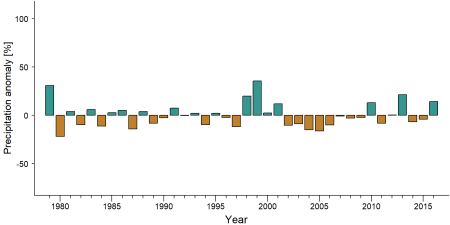
Precipitation anomaly in Ngotto Forest -
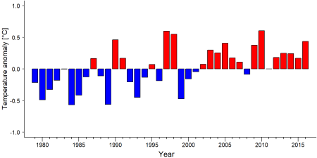
Temperature anomaly in Ngotto Forest


External links
References
Hicks, T. C., Fouts, R. S., & Fouts, D. H. (2009). A Survey of Chimpanzees (Pan troglodytes troglodytes) and Gorillas (Gorilla gorilla gorilla) in the Selectively Logged Ngotto Forest, Central African Republic. Journal of Applied Animal Welfare Science, 12(3), 165-188. doi:10.1080/10888700902955872
Hicks, T. C., Fouts, R. S., & Fouts, D. H. (2005). Chimpanzee (Pan troglodytes troglodytes) tool use in the Ngotto Forest, Central African Republic. American Journal of Primatology, 65(3), 221-237. doi:10.1002/ajp.20111
N'Goran, K. P., Beukou Choumbou, G. B., Ndotar, A., & Deguene, B. (2024). Inventaire de faune et de flore dans la forêt de Ngotto (Parc National Mbaéré Bodingué et sa périphérie). WWF/Bureau Régional pour l'Afrique/ Bureau du Cameroun/ Congo Basin Impact Monitoring Programme & WWF/Bureau de la République Centrafricaine.
Kiribou, R., Tehoda, P., Chukwu, O., Bempah, G., Kühl, H. S., Ferreira, J., …, & Heinicke, S. (2024). Exposure of African ape sites to climate change impacts. PLOS Climate, 3(2), e0000345. doi:10.1371/journal.pclm.0000345
Page created by: APES Atlas Team Date: 2021-01-08