
Ogooué-Leketi National Park: Difference between revisions
No edit summary |
No edit summary Tag: Manual revert |
||
| (3 intermediate revisions by the same user not shown) | |||
| Line 17: | Line 17: | ||
= Site characteristics = | = Site characteristics = | ||
Ogooué-Leketi National Park is located in the Republic of Congo, bordering [[Batéké Plateau National Park]] in Gabon. Together, the two parks form a transboundary protected area that covers over 5,500 sq.km (Dasgupta 2018). Ogooué-Leketi is part of the Batéké Plateau landscape, which is formed by a unique patchwork of savannas on sandy hills, dense forest that includes some trees taller than 60 m, and flooded forests along rivers (BirdLife International 2021, Dasgupta 2018). In 2009, the IUCN identified the region where the site is found as a priority conservation area for the protection of the critically endangered western lowland gorilla and the endangered central chimpanzee (Dasgupta 2018). The site is home to several threatened species, some of which are endemic; for example, the park has at least six species of rare savanna plants that are specialists of the Kalahari Sands, which forms the Batéké Plateau (Dasgupta 2018). Other species occurring at the site include the African forest elephant, forest buffalo, red river hog, mandrills, bush duiker, side-striped jackal, and several bird species (Dasgupta 2018). Since 2007 the area has been of high importance for bird conservation (BirdLife International 2021). | Ogooué-Leketi National Park is located in the Republic of Congo, bordering [[Batéké Plateau National Park]] in Gabon. Together, the two parks form a transboundary protected area that covers over 5,500 sq.km ([[#R01459|Dasgupta 2018]]). Ogooué-Leketi is part of the Batéké Plateau landscape, which is formed by a unique patchwork of savannas on sandy hills, dense forest that includes some trees taller than 60 m, and flooded forests along rivers ([[#R01458|BirdLife International 2021]], [[#R01459|Dasgupta 2018]]). In 2009, the IUCN identified the region where the site is found as a priority conservation area for the protection of the critically endangered western lowland gorilla and the endangered central chimpanzee ([[#R01459|Dasgupta 2018]]). The site is home to several threatened species, some of which are endemic; for example, the park has at least six species of rare savanna plants that are specialists of the Kalahari Sands, which forms the Batéké Plateau ([[#R01459|Dasgupta 2018]]). Other species occurring at the site include the African forest elephant, forest buffalo, red river hog, mandrills, bush duiker, side-striped jackal, and several bird species ([[#R01459|Dasgupta 2018]]). Since 2007 the area has been of high importance for bird conservation ([[#R01458|BirdLife International 2021]]). | ||
'''Table 1. Basic site information for Ogooué-Leketi National Park''' | '''Table 1. Basic site information for Ogooué-Leketi National Park''' | ||
| Line 92: | Line 92: | ||
= Threats = | = Threats = | ||
The site was designated as a National Park after three logging concessions that overlapped with the site were closed down. From 2013 to 2016 logging had expanded into the proposed park area. Logging companies are still active around the periphery of the park (Dasgupta 2018). The roads and bridges that the logging companies had built to access the site have facilitated commercial bushmeat hunting (Dasgupta 2018). Hunting is a major threat to the park's wildlife (Dasgupta 2018). | The site was designated as a National Park after three logging concessions that overlapped with the site were closed down. From 2013 to 2016 logging had expanded into the proposed park area. Logging companies are still active around the periphery of the park ([[#R01459|Dasgupta 2018]]). The roads and bridges that the logging companies had built to access the site have facilitated commercial bushmeat hunting ([[#R01459|Dasgupta 2018]]). Hunting is a major threat to the park's wildlife ([[#R01459|Dasgupta 2018]]). | ||
'''Table 3. Threats to apes reported for Ogooué-Leketi National Park''' | '''Table 3. Threats to apes reported for Ogooué-Leketi National Park''' | ||
| Line 105: | Line 105: | ||
|4.1 Roads & railroads | |4.1 Roads & railroads | ||
|Present (unknown severity) | |Present (unknown severity) | ||
|Roads and bridges built by logging companies in the past facilitate access to the forest for hunters (Dasgupta 2018). | |Roads and bridges built by logging companies in the past facilitate access to the forest for hunters ([[#R01459|Dasgupta 2018]]). | ||
|Ongoing (2018) | |Ongoing (2018) | ||
|- | |- | ||
| Line 111: | Line 111: | ||
|5.1 Hunting & collecting terrestrial animals | |5.1 Hunting & collecting terrestrial animals | ||
|High (more than 70% of population affected) | |High (more than 70% of population affected) | ||
|Commercial bushmeat hunting is a major threat (Dasgupta 2018). | |Commercial bushmeat hunting is a major threat ([[#R01459|Dasgupta 2018]]). | ||
|Ongoing (2018) | |Ongoing (2018) | ||
|- | |- | ||
| Line 117: | Line 117: | ||
|5.3 Logging & wood harvesting | |5.3 Logging & wood harvesting | ||
|High (more than 70% of population affected) | |High (more than 70% of population affected) | ||
|Three logging concessions that overlapped with the proposed park area stopped logging within the site in 2016; the logging companies are still active around the periphery of the park (Dasgupta 2018). | |Three logging concessions that overlapped with the proposed park area stopped logging within the site in 2016; the logging companies are still active around the periphery of the park ([[#R01459|Dasgupta 2018]]). | ||
|Ongoing (2018) | |Ongoing (2018) | ||
|} | |} | ||
| Line 125: | Line 125: | ||
= Conservation activities = | = Conservation activities = | ||
Since 2004, the Wildlife Conservation Society (WCS) and the Ministry of Forestry Economy have conducted biological and socio-economic surveys in the area to evaluate its conservation potential and define appropriate boundaries for what would become Ogooué-Leketi National Park (WCS 2018). The government of Congo and WCS-Congo worked with local communities in the process of establishing the park and creating a management plan for the park. There are five villages very close to the park boundary, whose residents have traditionally used the area for their needs, and continue to depend on the forest for their sustenance (Dasgupta 2018). The boundaries of Ogooué-Leketi were mapped to ensure the villages weren’t incorporated into the national park (Dasgupta 2018). The park includes eco-development zones, which are areas of cultural or natural resource use that are also high in ecological value (for example, bais, which are swampy forest clearings rich in minerals). In these eco-development zones, rights-holding communities are able to continue traditional and subsistence-based gathering, fishing or hunting (Dasgupta 2018). Currently, field activities, led by the Ministry of Forestry Economy of the Republic of the Congo in partnership with the NGO PANTHERA, are currently on hold pending the signing of the park’s Co-management Agreement (Roméo pers. comm. 2025). | Since 2004, the Wildlife Conservation Society (WCS) and the Ministry of Forestry Economy have conducted biological and socio-economic surveys in the area to evaluate its conservation potential and define appropriate boundaries for what would become Ogooué-Leketi National Park ([[#R01460|WCS 2018]]). The government of Congo and WCS-Congo worked with local communities in the process of establishing the park and creating a management plan for the park. There are five villages very close to the park boundary, whose residents have traditionally used the area for their needs, and continue to depend on the forest for their sustenance ([[#R01459|Dasgupta 2018]]). The boundaries of Ogooué-Leketi were mapped to ensure the villages weren’t incorporated into the national park ([[#R01459|Dasgupta 2018]]). The park includes eco-development zones, which are areas of cultural or natural resource use that are also high in ecological value (for example, bais, which are swampy forest clearings rich in minerals). In these eco-development zones, rights-holding communities are able to continue traditional and subsistence-based gathering, fishing or hunting ([[#R01459|Dasgupta 2018]]). Currently, field activities, led by the Ministry of Forestry Economy of the Republic of the Congo in partnership with the NGO PANTHERA, are currently on hold pending the signing of the park’s Co-management Agreement (Roméo pers. comm. 2025). | ||
'''Table 4. Conservation activities reported for Ogooué-Leketi National Park''' | '''Table 4. Conservation activities reported for Ogooué-Leketi National Park''' | ||
| Line 137: | Line 137: | ||
|4 Education & awareness | |4 Education & awareness | ||
|4.2 Involve local community in ape research and conservation management | |4.2 Involve local community in ape research and conservation management | ||
|Local communities were engaged and participated in the establishment of the park through a free and participatory social mapping ([ | |Local communities were engaged and participated in the establishment of the park through a free and participatory social mapping ([[#R01460|WCS 2018]]). | ||
|WCS, Local communities, Governmet of Congo | |WCS, Local communities, Governmet of Congo | ||
|2004-2018 | |2004-2018 | ||
| Line 149: | Line 149: | ||
|5 Protection & restoration | |5 Protection & restoration | ||
|5.5 Demarcate and enforce boundaries of protected areas | |5.5 Demarcate and enforce boundaries of protected areas | ||
|Mapping survey and activities conducted to determine park boundaries and evaluate conservation potential ([ | |Mapping survey and activities conducted to determine park boundaries and evaluate conservation potential ([[#R01460|WCS 2018]]). | ||
|WCS, Ministry of Forestry Economy | |WCS, Ministry of Forestry Economy | ||
|2004-2018 | |2004-2018 | ||
| Line 280: | Line 280: | ||
= Exposure to climate change impacts = | = Exposure to climate change impacts = | ||
As part of a study on the exposure of African great ape sites to climate change impacts, Kiribou et al. (2024) extracted climate data and data on projected extreme climate impact events for the site. Climatological characteristics were derived from observation-based climate data provided by the Inter-Sectoral Impact Model Intercomparison Project (ISIMIP, www.isimip.org). Parameters were calculated as the average across each 30-year period. For 1981-2010, the EWEMBI dataset from ISIMIP2a was used. For the two future periods (2021-2050 and 2071-2099) ISIMIP2b climate data based on four CMIP5 global climate models were used. For future projections, two Representative Concentration Pathways (RCP) were used. RCP 2.6 is a scenario with strong mitigation measures in which global temperatures would likely rise below 2C. RCP 6.0 is a scenario with medium emissions in which global temperatures would likely rise up to 3C by 2100. For the number of days with heavy precipitation events, the 98th percentile of all precipitation days (>1mm/d) was calculated for the 1979-2013 reference period as a threshold for a heavy precipitation event. Then, for each year, the number of days above that threshold was derived. The figures on temperature and precipitation anomaly show the deviation from the mean temperature and mean precipitation for the 1979-2013 reference period. | As part of a study on the exposure of African great ape sites to climate change impacts, [[#R02293|Kiribou et al. (2024)]] extracted climate data and data on projected extreme climate impact events for the site. Climatological characteristics were derived from observation-based climate data provided by the Inter-Sectoral Impact Model Intercomparison Project (ISIMIP, www.isimip.org). Parameters were calculated as the average across each 30-year period. For 1981-2010, the EWEMBI dataset from ISIMIP2a was used. For the two future periods (2021-2050 and 2071-2099) ISIMIP2b climate data based on four CMIP5 global climate models were used. For future projections, two Representative Concentration Pathways (RCP) were used. RCP 2.6 is a scenario with strong mitigation measures in which global temperatures would likely rise below 2C. RCP 6.0 is a scenario with medium emissions in which global temperatures would likely rise up to 3C by 2100. For the number of days with heavy precipitation events, the 98th percentile of all precipitation days (>1mm/d) was calculated for the 1979-2013 reference period as a threshold for a heavy precipitation event. Then, for each year, the number of days above that threshold was derived. The figures on temperature and precipitation anomaly show the deviation from the mean temperature and mean precipitation for the 1979-2013 reference period. | ||
The estimated exposure to future extreme climate impact events (crop failure, drought, river flood, wildfire, tropical cyclone, and heatwave) is based on a published dataset by Lange et al. 2020 derived from ISIMIP2b data. The same global climate models and RCPs as described above were used. Within each 30-year period, the number of years with an extreme event and the average proportion of the site affected were calculated (Kiribou et al. 2024). | The estimated exposure to future extreme climate impact events (crop failure, drought, river flood, wildfire, tropical cyclone, and heatwave) is based on a published dataset by Lange et al. 2020 derived from ISIMIP2b data. The same global climate models and RCPs as described above were used. Within each 30-year period, the number of years with an extreme event and the average proportion of the site affected were calculated ([[#R02293|Kiribou et al. 2024]]). | ||
'''Table 8. Estimated past and projected climatological characteristics in Ogooué-Leketi National Park''' | '''Table 8. Estimated past and projected climatological characteristics in Ogooué-Leketi National Park''' | ||
| Line 405: | Line 405: | ||
= References = | = References = | ||
BirdLife International (2021) Important Bird Areas factsheet: Ogooué Leketi National Park. Downloaded from http://www.birdlife.org on 28/10/2021. | <span id="R01458"></span>BirdLife International (2021) Important Bird Areas factsheet: Ogooué Leketi National Park. Downloaded from http://www.birdlife.org on 28/10/2021. | ||
Dasgupta, S. (2018). Republic of Congo names new national park, home to gorillas, elephants. Online: https://news.mongabay.com/2018/11/republic-of-congo-names-new-national-park-home-to-gorillas-elephants/ | <span id="R01459"></span>Dasgupta, S. (2018). Republic of Congo names new national park, home to gorillas, elephants. Online: https://news.mongabay.com/2018/11/republic-of-congo-names-new-national-park-home-to-gorillas-elephants/ | ||
WCS. (2018). Creation of Ogooue-Leketi National Park. Online: https://newsroom.wcs.org/News-Releases/articleType/ArticleView/articleId/11706/Creation-of-Ogooue-Leketi-National-Park.aspx | <span id="R01460"></span>WCS. (2018). Creation of Ogooue-Leketi National Park. Online: https://newsroom.wcs.org/News-Releases/articleType/ArticleView/articleId/11706/Creation-of-Ogooue-Leketi-National-Park.aspx | ||
<span id="R02293"></span>Kiribou, R., Tehoda, P., Chukwu, O., Bempah, G., Kühl, H. S., Ferreira, J., …, & Heinicke, S. (2024). Exposure of African ape sites to climate change impacts. ''PLOS Climate'', 3(2), e0000345. [https://doi.org/10.1371/journal.pclm.0000345 doi:10.1371/journal.pclm.0000345] | |||
Latest revision as of 17:54, 15 October 2026
Central Africa > Republic of the Congo > Ogooué-Leketi National Park
Français | Português | Español | Bahasa Indonesia | Melayu
Summary
- Central chimpanzees (Pan troglodytes troglodytes) & Western lowland gorillas (Gorilla gorilla gorilla) are present in Ogooué-Leketi National Park.
- The population sizes are unknown.
- The population trends are unknown.
- The site has a total size of 3,500 km².
- Key threats to great apes are hunting and logging.
- The primary reported conservation activities include awareness-raising and education, employment of local communities in conservation projects, and support for the development of ecotourism ventures.
Site characteristics
Ogooué-Leketi National Park is located in the Republic of Congo, bordering Batéké Plateau National Park in Gabon. Together, the two parks form a transboundary protected area that covers over 5,500 sq.km (Dasgupta 2018). Ogooué-Leketi is part of the Batéké Plateau landscape, which is formed by a unique patchwork of savannas on sandy hills, dense forest that includes some trees taller than 60 m, and flooded forests along rivers (BirdLife International 2021, Dasgupta 2018). In 2009, the IUCN identified the region where the site is found as a priority conservation area for the protection of the critically endangered western lowland gorilla and the endangered central chimpanzee (Dasgupta 2018). The site is home to several threatened species, some of which are endemic; for example, the park has at least six species of rare savanna plants that are specialists of the Kalahari Sands, which forms the Batéké Plateau (Dasgupta 2018). Other species occurring at the site include the African forest elephant, forest buffalo, red river hog, mandrills, bush duiker, side-striped jackal, and several bird species (Dasgupta 2018). Since 2007 the area has been of high importance for bird conservation (BirdLife International 2021).
Table 1. Basic site information for Ogooué-Leketi National Park
| Species | Pan troglodytes troglodytes, Gorilla gorilla gorilla |
| Area | 3,486.94 km² |
| Coordinates | Lat: -2.228976 , Lon: 14.344131 |
| Type of site | Protected area (National Park) |
| Habitat types | Subtropical/tropical moist lowland forest, Savanna, Subtropical/tropical swamp forest |
| Type of governance | Shared governance |
Types of sites Governance types Habitat types
Ape status
Table 2. Ape population estimates reported for Ogooué-Leketi National Park
| Species | Year | Occurrence | Encounter or vistation rate (nests/km; ind/day) | Density estimate [ind./ km²] (95% CI) | Abundance estimate (95% CI) | Survey area | Sampling method | Analytical framework | Source | Comments | A.P.E.S. database ID |
|---|---|---|---|---|---|---|---|---|---|---|---|
| Gorilla gorilla gorilla | Ogooué-Leketi National Park | ||||||||||
| Pan troglodytes troglodytes | Ogooué-Leketi National Park |
Sampling methods Analytical frameworks
Threats
The site was designated as a National Park after three logging concessions that overlapped with the site were closed down. From 2013 to 2016 logging had expanded into the proposed park area. Logging companies are still active around the periphery of the park (Dasgupta 2018). The roads and bridges that the logging companies had built to access the site have facilitated commercial bushmeat hunting (Dasgupta 2018). Hunting is a major threat to the park's wildlife (Dasgupta 2018).
Table 3. Threats to apes reported for Ogooué-Leketi National Park
| Category | Specific threats | Threat level | Description | Year of threat |
|---|---|---|---|---|
| 4 Transportation & service corridors | 4.1 Roads & railroads | Present (unknown severity) | Roads and bridges built by logging companies in the past facilitate access to the forest for hunters (Dasgupta 2018). | Ongoing (2018) |
| 5 Biological resource use | 5.1 Hunting & collecting terrestrial animals | High (more than 70% of population affected) | Commercial bushmeat hunting is a major threat (Dasgupta 2018). | Ongoing (2018) |
| 5 Biological resource use | 5.3 Logging & wood harvesting | High (more than 70% of population affected) | Three logging concessions that overlapped with the proposed park area stopped logging within the site in 2016; the logging companies are still active around the periphery of the park (Dasgupta 2018). | Ongoing (2018) |
Conservation activities
Since 2004, the Wildlife Conservation Society (WCS) and the Ministry of Forestry Economy have conducted biological and socio-economic surveys in the area to evaluate its conservation potential and define appropriate boundaries for what would become Ogooué-Leketi National Park (WCS 2018). The government of Congo and WCS-Congo worked with local communities in the process of establishing the park and creating a management plan for the park. There are five villages very close to the park boundary, whose residents have traditionally used the area for their needs, and continue to depend on the forest for their sustenance (Dasgupta 2018). The boundaries of Ogooué-Leketi were mapped to ensure the villages weren’t incorporated into the national park (Dasgupta 2018). The park includes eco-development zones, which are areas of cultural or natural resource use that are also high in ecological value (for example, bais, which are swampy forest clearings rich in minerals). In these eco-development zones, rights-holding communities are able to continue traditional and subsistence-based gathering, fishing or hunting (Dasgupta 2018). Currently, field activities, led by the Ministry of Forestry Economy of the Republic of the Congo in partnership with the NGO PANTHERA, are currently on hold pending the signing of the park’s Co-management Agreement (Roméo pers. comm. 2025).
Table 4. Conservation activities reported for Ogooué-Leketi National Park
| Category | Specific activity | Description | Implementing organization(s) | Year of activity |
|---|---|---|---|---|
| 4 Education & awareness | 4.2 Involve local community in ape research and conservation management | Local communities were engaged and participated in the establishment of the park through a free and participatory social mapping (WCS 2018). | WCS, Local communities, Governmet of Congo | 2004-2018 |
| 5 Protection & restoration | 5.2 Legally protect ape habitat | The national park was established in 2018. | 2018-Ongoing (2026) | |
| 5 Protection & restoration | 5.5 Demarcate and enforce boundaries of protected areas | Mapping survey and activities conducted to determine park boundaries and evaluate conservation potential (WCS 2018). | WCS, Ministry of Forestry Economy | 2004-2018 |
Challenges
Table 5. Challenges reported for Ogooué-Leketi National Park
| Challenges | Specific challenges | Source | Year(s) |
|---|---|---|---|
| 2 Resources and capacity | 2.2 Lack of staff | Roméo pers. comm. 2025 | Ongoing (2025) |
| 2 Resources and capacity | 2.3 General lack of funding | Roméo pers. comm. 2025 | Ongoing (2025) |
| 2 Resources and capacity | 2.4 Lack of continuous/long-term funding | Roméo pers. comm. 2025 | Ongoing (2025) |
Enablers
Table 6. Enablers reported for Ogooué-Leketi National Park
| Enablers | Specific enablers | Source | Year(s) |
|---|---|---|---|
| 2 Resources and capacity | 2.6 External partnerships that add expertise or resources | Roméo pers. comm. 2025 | Ongoing (2025) |
| 3 Engaged community | 3.1 Strong local environmental knowledge | WCS Study Report 2005 | Ongoing (2005) |
| 3 Engaged community | 3.6 Local community engagement and support | WCS Study Report 2005 | Ongoing (2005) |
| 4 Institutional support | 4.1 Effective legislation and law enforcement | Official Gazette No. 2023-01 of January 5, 2023 | Ongoing (2022) |
| 4 Institutional support | 4.2 Strong government support | WCS Study Report 2005 | Ongoing (2022) |
| 4 Institutional support | 4.3 Strong transboundary cooperation | WCS Study Report 2005 | Ongoing (2005) |
| 5 Ecological context | 5.1 Ecological characteristics (e.g. terrain) conducive to conservation | WCS Study Report 2005 | 2005-Ongoing (2025) |
| 1 Site management | |||
| 6 Safety and stability |
Research activities
Documented behaviours
Table 7. Behaviours documented for Ogooué-Leketi National Park
| Category | Behavior | Observation type | Prevalence | Observation dates | Source | Habituation | Species | Comment |
|---|---|---|---|---|---|---|---|---|
| Not reported |
Exposure to climate change impacts
As part of a study on the exposure of African great ape sites to climate change impacts, Kiribou et al. (2024) extracted climate data and data on projected extreme climate impact events for the site. Climatological characteristics were derived from observation-based climate data provided by the Inter-Sectoral Impact Model Intercomparison Project (ISIMIP, www.isimip.org). Parameters were calculated as the average across each 30-year period. For 1981-2010, the EWEMBI dataset from ISIMIP2a was used. For the two future periods (2021-2050 and 2071-2099) ISIMIP2b climate data based on four CMIP5 global climate models were used. For future projections, two Representative Concentration Pathways (RCP) were used. RCP 2.6 is a scenario with strong mitigation measures in which global temperatures would likely rise below 2C. RCP 6.0 is a scenario with medium emissions in which global temperatures would likely rise up to 3C by 2100. For the number of days with heavy precipitation events, the 98th percentile of all precipitation days (>1mm/d) was calculated for the 1979-2013 reference period as a threshold for a heavy precipitation event. Then, for each year, the number of days above that threshold was derived. The figures on temperature and precipitation anomaly show the deviation from the mean temperature and mean precipitation for the 1979-2013 reference period.
The estimated exposure to future extreme climate impact events (crop failure, drought, river flood, wildfire, tropical cyclone, and heatwave) is based on a published dataset by Lange et al. 2020 derived from ISIMIP2b data. The same global climate models and RCPs as described above were used. Within each 30-year period, the number of years with an extreme event and the average proportion of the site affected were calculated (Kiribou et al. 2024).
Table 8. Estimated past and projected climatological characteristics in Ogooué-Leketi National Park
| Value | 1981-2010 | 2021-2050, RCP 2.6 | 2021-2050, RCP 6.0 | 2071-2099, RCP 2.6 | 2071-2099, RCP 6.0 |
|---|---|---|---|---|---|
| Mean temperature [C] | 23.8 | 25 | 24.8 | 25.1 | 26.1 |
| Annual precipitation [mm] | 2422 | 2433 | 2475 | 2480 | 2476 |
| Max no. consecutive dry days (per year) | 29.6 | 21.4 | 19.5 | 24.2 | 21.5 |
| No. days with heavy precipitation (per year) | 6.4 | 9.7 | 9.2 | 8.9 | 9.5 |
Table 9. Projected exposure of apes to extreme climate impact events in Ogooué-Leketi National Park
| Type | No. of years with event (2021-2050, RCP 2.6) | % of site exposed (2021-2050, RCP 2.6) | No. of years with event (2021-2050, RCP 6.0) | % of site exposed (2021-2050, RCP 6.0) | No. of years with event (2070-2099, RCP 2.6) | % of site exposed (2070-2099, RCP 2.6) | No. of years with event (2070-2099, RCP 6.0) | % of site exposed (2070-2099, RCP 6.0) |
|---|---|---|---|---|---|---|---|---|
| Crop failure | 12.5 | 0.06 | 11 | 0.07 | 8 | 0.05 | 21 | 0.05 |
| Drought | 0 | 0 | 0 | 0 | 0 | 0 | 0 | 0 |
| Heatwave | 1 | 37.5 | 2 | 25 | 1 | 40 | 4.5 | 37.5 |
| River flood | 0 | 0 | 0 | 0 | 0.5 | 0.03 | 0.5 | 0.08 |
| Tropical cyclone | 0 | 0 | 0 | 0 | 0 | 0 | 0 | 0 |
| Wildfire | 30 | 0.28 | 30 | 0.26 | 29 | 0.32 | 29 | 0.27 |
-
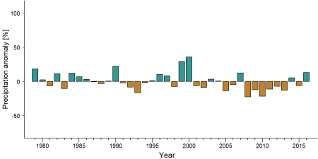
Precipitation anomaly in Ogooué-Leketi National Park -
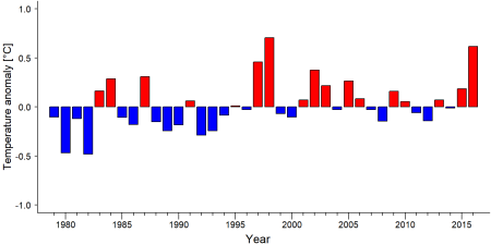
Temperature anomaly in Ogooué-Leketi National Park


External links
References
BirdLife International (2021) Important Bird Areas factsheet: Ogooué Leketi National Park. Downloaded from http://www.birdlife.org on 28/10/2021.
Dasgupta, S. (2018). Republic of Congo names new national park, home to gorillas, elephants. Online: https://news.mongabay.com/2018/11/republic-of-congo-names-new-national-park-home-to-gorillas-elephants/
WCS. (2018). Creation of Ogooue-Leketi National Park. Online: https://newsroom.wcs.org/News-Releases/articleType/ArticleView/articleId/11706/Creation-of-Ogooue-Leketi-National-Park.aspx
Kiribou, R., Tehoda, P., Chukwu, O., Bempah, G., Kühl, H. S., Ferreira, J., …, & Heinicke, S. (2024). Exposure of African ape sites to climate change impacts. PLOS Climate, 3(2), e0000345. doi:10.1371/journal.pclm.0000345
Page created by: APES Atlas Team Date: 2021-10-29
Page updated by: Roméo Omer Kamta Tchoffo Date: 2025-07-24