
Souanké-Sembe Landscape: Difference between revisions
No edit summary |
No edit summary Tag: Manual revert |
||
| (2 intermediate revisions by the same user not shown) | |||
| Line 17: | Line 17: | ||
= Site characteristics = | = Site characteristics = | ||
The Souanké-Sembe landscape is located in northwestern Congo, bordering Gabon to the west and Cameroon to the north. The landscape covers about 14,535 km², and includes the proposed protected area of Messok Dja (1,400 km²) and the 9,000 km² Djoua Ivindo Forest (IUCN 2014). The landscape has been identified as an important area for the conservation of chimpanzees and western lowland gorillas since the early 2000s. The area is characterized by a mix of swamp and terra firma forest with large stands of Gilbertiodendron dewevrei, and includes Congo’s highest mountain, Mont Nabemba, at 1,020 m asl. The site forms an important link between [[Nki National Park]] in Cameroon, [[Minkébé National Park]] in Gabon and [[Odzala-Kokoua National Park]] in Congo (IUCN 2014). | The Souanké-Sembe landscape is located in northwestern Congo, bordering Gabon to the west and Cameroon to the north. The landscape covers about 14,535 km², and includes the proposed protected area of Messok Dja (1,400 km²) and the 9,000 km² Djoua Ivindo Forest ([[#R01723|IUCN 2014]]). The landscape has been identified as an important area for the conservation of chimpanzees and western lowland gorillas since the early 2000s. The area is characterized by a mix of swamp and terra firma forest with large stands of Gilbertiodendron dewevrei, and includes Congo’s highest mountain, Mont Nabemba, at 1,020 m asl. The site forms an important link between [[Nki National Park]] in Cameroon, [[Minkébé National Park]] in Gabon and [[Odzala-Kokoua National Park]] in Congo ([[#R01723|IUCN 2014]]). | ||
'''Table 1. Basic site information for Souanké-Sembe Landscape''' | '''Table 1. Basic site information for Souanké-Sembe Landscape''' | ||
| Line 79: | Line 79: | ||
= Threats = | = Threats = | ||
The Jua Ikié FMU (5,740 km²) and Tala Tala FMU (6,211 km²) were allocated to a Chinese company, SEFYD, and a Lebanese company, SIFCO, respectively (IUCN 2014). Both concessions overlap with the proposed Messok Dja protected area. In 2014, the Ministry of Forest Economy and Sustainable Development (MEFDD) created the Karagoua FMU (6,533 km²), that borders Minkébé NP and overlaps with the Djoua Ivindo Forest; possible attribution of this remote forest to a logging company poses a new threat (IUCN 2014). Three large iron-ore mining projects are planned in Djoua Ivindo. Other pressures on wildlife come from artisanal gold mining, and the proposed 600-MW Chollet hydroelectric dam on the Dja River (which would impact great apes in Nki and Messok Dja). Tarmacking of the Ouesso-Sembe-Souanké-Ntam road is facilitating access to the region, resulting in a booming bushmeat trade, linked to the markets of Ouesso and Brazzaville (IUCN 2014). | The Jua Ikié FMU (5,740 km²) and Tala Tala FMU (6,211 km²) were allocated to a Chinese company, SEFYD, and a Lebanese company, SIFCO, respectively ([[#R01723|IUCN 2014]]). Both concessions overlap with the proposed Messok Dja protected area. In 2014, the Ministry of Forest Economy and Sustainable Development (MEFDD) created the Karagoua FMU (6,533 km²), that borders Minkébé NP and overlaps with the Djoua Ivindo Forest; possible attribution of this remote forest to a logging company poses a new threat ([[#R01723|IUCN 2014]]). Three large iron-ore mining projects are planned in Djoua Ivindo. Other pressures on wildlife come from artisanal gold mining, and the proposed 600-MW Chollet hydroelectric dam on the Dja River (which would impact great apes in Nki and Messok Dja). Tarmacking of the Ouesso-Sembe-Souanké-Ntam road is facilitating access to the region, resulting in a booming bushmeat trade, linked to the markets of Ouesso and Brazzaville ([[#R01723|IUCN 2014]]). | ||
'''Table 3. Threats to apes reported for Souanké-Sembe Landscape''' | '''Table 3. Threats to apes reported for Souanké-Sembe Landscape''' | ||
| Line 92: | Line 92: | ||
|3.2 Mining & quarrying | |3.2 Mining & quarrying | ||
|Present (unknown severity) | |Present (unknown severity) | ||
|Artisanal gold mining (IUCN 2014). | |Artisanal gold mining ([[#R01723|IUCN 2014]]). | ||
|Ongoing (2014) | |Ongoing (2014) | ||
|- | |- | ||
| Line 98: | Line 98: | ||
|4.1 Roads & railroads | |4.1 Roads & railroads | ||
|High (more than 70% of population affected) | |High (more than 70% of population affected) | ||
|Tarmacking of a road that provides access to previously isolated areas (IUCN 2014). | |Tarmacking of a road that provides access to previously isolated areas ([[#R01723|IUCN 2014]]). | ||
|Ongoing (2014) | |Ongoing (2014) | ||
|- | |- | ||
| Line 104: | Line 104: | ||
|5.1 Hunting & collecting terrestrial animals | |5.1 Hunting & collecting terrestrial animals | ||
|Present (unknown severity) | |Present (unknown severity) | ||
|Improved access to the forest leading to higher bushmeat offtake (IUCN 2014). | |Improved access to the forest leading to higher bushmeat offtake ([[#R01723|IUCN 2014]]). | ||
|Ongoing (2014) | |Ongoing (2014) | ||
|- | |- | ||
| Line 110: | Line 110: | ||
|5.3 Logging & wood harvesting | |5.3 Logging & wood harvesting | ||
|High (more than 70% of population affected) | |High (more than 70% of population affected) | ||
|Logging concessions (IUCN 2014). | |Logging concessions ([[#R01723|IUCN 2014]]). | ||
|Ongoing (2014) | |Ongoing (2014) | ||
|- | |- | ||
| Line 116: | Line 116: | ||
|7.2 Dams & water management/use | |7.2 Dams & water management/use | ||
|High (more than 70% of population affected) | |High (more than 70% of population affected) | ||
|Development of the Chollet hydroelectric dam on the Dja River will affect great apes in Nki and Messok Dja (IUCN 2014). | |Development of the Chollet hydroelectric dam on the Dja River will affect great apes in Nki and Messok Dja ([[#R01723|IUCN 2014]]). | ||
|Ongoing (2014) | |Ongoing (2014) | ||
|} | |} | ||
| Line 136: | Line 136: | ||
|2 Counter-wildlife crime | |2 Counter-wildlife crime | ||
|2.1 Implement road blocks to inspect cars for illegal ape bushmeat | |2.1 Implement road blocks to inspect cars for illegal ape bushmeat | ||
|Development and implementation of wildlife management plans by logging companies, including support for additional ecoguard units and roadblocks (IUCN 2014). | |Development and implementation of wildlife management plans by logging companies, including support for additional ecoguard units and roadblocks ([[#R01723|IUCN 2014]]). | ||
| | | | ||
|Ongoing (2014) | |Ongoing (2014) | ||
| Line 142: | Line 142: | ||
|2 Counter-wildlife crime | |2 Counter-wildlife crime | ||
|2.3 Conduct regular anti-poaching patrols | |2.3 Conduct regular anti-poaching patrols | ||
|Joint patrols are conducted with Cameroon (Messok Dja-Nki border) and Gabon (Minkébé border, Djoua River); establishment of ecoguard units in collaboration with mining companies in Djoua Ivindo (IUCN 2014). | |Joint patrols are conducted with Cameroon (Messok Dja-Nki border) and Gabon (Minkébé border, Djoua River); establishment of ecoguard units in collaboration with mining companies in Djoua Ivindo ([[#R01723|IUCN 2014]]). | ||
| | | | ||
|Ongoing (2014) | |Ongoing (2014) | ||
| Line 248: | Line 248: | ||
= Exposure to climate change impacts = | = Exposure to climate change impacts = | ||
As part of a study on the exposure of African great ape sites to climate change impacts, Kiribou et al. (2024) extracted climate data and data on projected extreme climate impact events for the site. Climatological characteristics were derived from observation-based climate data provided by the Inter-Sectoral Impact Model Intercomparison Project (ISIMIP, www.isimip.org). Parameters were calculated as the average across each 30-year period. For 1981-2010, the EWEMBI dataset from ISIMIP2a was used. For the two future periods (2021-2050 and 2071-2099) ISIMIP2b climate data based on four CMIP5 global climate models were used. For future projections, two Representative Concentration Pathways (RCP) were used. RCP 2.6 is a scenario with strong mitigation measures in which global temperatures would likely rise below 2C. RCP 6.0 is a scenario with medium emissions in which global temperatures would likely rise up to 3C by 2100. For the number of days with heavy precipitation events, the 98th percentile of all precipitation days (>1mm/d) was calculated for the 1979-2013 reference period as a threshold for a heavy precipitation event. Then, for each year, the number of days above that threshold was derived. The figures on temperature and precipitation anomaly show the deviation from the mean temperature and mean precipitation for the 1979-2013 reference period. | As part of a study on the exposure of African great ape sites to climate change impacts, [[#R02318|Kiribou et al. (2024)]] extracted climate data and data on projected extreme climate impact events for the site. Climatological characteristics were derived from observation-based climate data provided by the Inter-Sectoral Impact Model Intercomparison Project (ISIMIP, www.isimip.org). Parameters were calculated as the average across each 30-year period. For 1981-2010, the EWEMBI dataset from ISIMIP2a was used. For the two future periods (2021-2050 and 2071-2099) ISIMIP2b climate data based on four CMIP5 global climate models were used. For future projections, two Representative Concentration Pathways (RCP) were used. RCP 2.6 is a scenario with strong mitigation measures in which global temperatures would likely rise below 2C. RCP 6.0 is a scenario with medium emissions in which global temperatures would likely rise up to 3C by 2100. For the number of days with heavy precipitation events, the 98th percentile of all precipitation days (>1mm/d) was calculated for the 1979-2013 reference period as a threshold for a heavy precipitation event. Then, for each year, the number of days above that threshold was derived. The figures on temperature and precipitation anomaly show the deviation from the mean temperature and mean precipitation for the 1979-2013 reference period. | ||
The estimated exposure to future extreme climate impact events (crop failure, drought, river flood, wildfire, tropical cyclone, and heatwave) is based on a published dataset by Lange et al. 2020 derived from ISIMIP2b data. The same global climate models and RCPs as described above were used. Within each 30-year period, the number of years with an extreme event and the average proportion of the site affected were calculated (Kiribou et al. 2024). | The estimated exposure to future extreme climate impact events (crop failure, drought, river flood, wildfire, tropical cyclone, and heatwave) is based on a published dataset by Lange et al. 2020 derived from ISIMIP2b data. The same global climate models and RCPs as described above were used. Within each 30-year period, the number of years with an extreme event and the average proportion of the site affected were calculated ([[#R02318|Kiribou et al. 2024]]). | ||
'''Table 8. Estimated past and projected climatological characteristics in Souanké-Sembe Landscape''' | '''Table 8. Estimated past and projected climatological characteristics in Souanké-Sembe Landscape''' | ||
| Line 373: | Line 373: | ||
= References = | = References = | ||
IUCN (2014). Regional Action Plan for the Conservation of Western Lowland Gorillas and Central Chimpanzees 2015–2025. | <span id="R01723"></span>IUCN - International Union for Conservation of Nature (2014). Regional Action Plan for the Conservation of Western Lowland Gorillas and Central Chimpanzees 2015–2025. International Union for Conservation of Nature. [https://doi.org/10.2305/iucn.ch.2005.ssc-rap.1.en doi:10.2305/iucn.ch.2005.ssc-rap.1.en] | ||
<span id="R02318"></span>Kiribou, R., Tehoda, P., Chukwu, O., Bempah, G., Kühl, H. S., Ferreira, J., …, & Heinicke, S. (2024). Exposure of African ape sites to climate change impacts. ''PLOS Climate'', 3(2), e0000345. [https://doi.org/10.1371/journal.pclm.0000345 doi:10.1371/journal.pclm.0000345] | |||
'''Page created by: '''APES Atlas Team''' Date:''' 2022-01-10 | '''Page created by: '''APES Atlas Team''' Date:''' 2022-01-10 | ||
Latest revision as of 17:54, 15 October 2026
Central Africa > Republic of the Congo > Souanké-Sembe Landscape
Français | Português | Español | Bahasa Indonesia | Melayu
Summary
- Central chimpanzees (Pan troglodytes troglodytes) & Western lowland gorillas (Gorilla gorilla gorilla) are present in Souanké-Sembe Landscape.
- The population sizes are unknown.
- The great ape population trend is unknown.
- The site has a total size of 14,535 km².
- Key threats to great apes are logging, roads, mining, construction of a hydroelectric dam, and poaching.
- Conservation activities have focused on anti-poaching patrols and roadblocks.
Site characteristics
The Souanké-Sembe landscape is located in northwestern Congo, bordering Gabon to the west and Cameroon to the north. The landscape covers about 14,535 km², and includes the proposed protected area of Messok Dja (1,400 km²) and the 9,000 km² Djoua Ivindo Forest (IUCN 2014). The landscape has been identified as an important area for the conservation of chimpanzees and western lowland gorillas since the early 2000s. The area is characterized by a mix of swamp and terra firma forest with large stands of Gilbertiodendron dewevrei, and includes Congo’s highest mountain, Mont Nabemba, at 1,020 m asl. The site forms an important link between Nki National Park in Cameroon, Minkébé National Park in Gabon and Odzala-Kokoua National Park in Congo (IUCN 2014).
Table 1. Basic site information for Souanké-Sembe Landscape
| Species | Pan troglodytes troglodytes, Gorilla gorilla gorilla |
| Area | 14,535 km² |
| Coordinates | Lat: 1.969855 , Lon: 13.936844 |
| Type of site | Non-protected area |
| Habitat types | Subtropical/tropical moist lowland forest, Subtropical/tropical swamp forest |
| Type of governance |
Types of sites Governance types Habitat types
Ape status
Table 2. Ape population estimates reported for Souanké-Sembe Landscape
| Species | Year | Occurrence | Encounter or vistation rate (nests/km; ind/day) | Density estimate [ind./ km²] (95% CI) | Abundance estimate (95% CI) | Survey area | Sampling method | Analytical framework | Source | Comments | A.P.E.S. database ID |
|---|---|---|---|---|---|---|---|---|---|---|---|
| Pan troglodytes troglodytes & Gorilla gorilla gorilla | Souanké-Sembe Landscape |
Sampling methods Analytical frameworks
Threats
The Jua Ikié FMU (5,740 km²) and Tala Tala FMU (6,211 km²) were allocated to a Chinese company, SEFYD, and a Lebanese company, SIFCO, respectively (IUCN 2014). Both concessions overlap with the proposed Messok Dja protected area. In 2014, the Ministry of Forest Economy and Sustainable Development (MEFDD) created the Karagoua FMU (6,533 km²), that borders Minkébé NP and overlaps with the Djoua Ivindo Forest; possible attribution of this remote forest to a logging company poses a new threat (IUCN 2014). Three large iron-ore mining projects are planned in Djoua Ivindo. Other pressures on wildlife come from artisanal gold mining, and the proposed 600-MW Chollet hydroelectric dam on the Dja River (which would impact great apes in Nki and Messok Dja). Tarmacking of the Ouesso-Sembe-Souanké-Ntam road is facilitating access to the region, resulting in a booming bushmeat trade, linked to the markets of Ouesso and Brazzaville (IUCN 2014).
Table 3. Threats to apes reported for Souanké-Sembe Landscape
| Category | Specific threats | Threat level | Description | Year of threat |
|---|---|---|---|---|
| 3 Energy production & mining | 3.2 Mining & quarrying | Present (unknown severity) | Artisanal gold mining (IUCN 2014). | Ongoing (2014) |
| 4 Transportation & service corridors | 4.1 Roads & railroads | High (more than 70% of population affected) | Tarmacking of a road that provides access to previously isolated areas (IUCN 2014). | Ongoing (2014) |
| 5 Biological resource use | 5.1 Hunting & collecting terrestrial animals | Present (unknown severity) | Improved access to the forest leading to higher bushmeat offtake (IUCN 2014). | Ongoing (2014) |
| 5 Biological resource use | 5.3 Logging & wood harvesting | High (more than 70% of population affected) | Logging concessions (IUCN 2014). | Ongoing (2014) |
| 7 Natural system modifications | 7.2 Dams & water management/use | High (more than 70% of population affected) | Development of the Chollet hydroelectric dam on the Dja River will affect great apes in Nki and Messok Dja (IUCN 2014). | Ongoing (2014) |
Conservation activities
Table 4. Conservation activities reported for Souanké-Sembe Landscape
| Category | Specific activity | Description | Implementing organization(s) | Year of activity |
|---|---|---|---|---|
| 2 Counter-wildlife crime | 2.1 Implement road blocks to inspect cars for illegal ape bushmeat | Development and implementation of wildlife management plans by logging companies, including support for additional ecoguard units and roadblocks (IUCN 2014). | Ongoing (2014) | |
| 2 Counter-wildlife crime | 2.3 Conduct regular anti-poaching patrols | Joint patrols are conducted with Cameroon (Messok Dja-Nki border) and Gabon (Minkébé border, Djoua River); establishment of ecoguard units in collaboration with mining companies in Djoua Ivindo (IUCN 2014). | Ongoing (2014) |
Challenges
Table 5. Challenges reported for Souanké-Sembe Landscape
| Challenges | Specific challenges | Source | Year(s) |
|---|---|---|---|
| Not reported |
Enablers
Table 6. Enablers reported for Souanké-Sembe Landscape
| Enablers | Specific enablers | Source | Year(s) |
|---|---|---|---|
| 1 Site management | |||
| 2 Resources and capacity | |||
| 3 Engaged community | |||
| 4 Institutional support | |||
| 5 Ecological context | |||
| 6 Safety and stability |
Research activities
Documented behaviours
Table 7. Behaviours documented for Souanké-Sembe Landscape
| Category | Behavior | Observation type | Prevalence | Observation dates | Source | Habituation | Species | Comment |
|---|---|---|---|---|---|---|---|---|
| Not reported |
Exposure to climate change impacts
As part of a study on the exposure of African great ape sites to climate change impacts, Kiribou et al. (2024) extracted climate data and data on projected extreme climate impact events for the site. Climatological characteristics were derived from observation-based climate data provided by the Inter-Sectoral Impact Model Intercomparison Project (ISIMIP, www.isimip.org). Parameters were calculated as the average across each 30-year period. For 1981-2010, the EWEMBI dataset from ISIMIP2a was used. For the two future periods (2021-2050 and 2071-2099) ISIMIP2b climate data based on four CMIP5 global climate models were used. For future projections, two Representative Concentration Pathways (RCP) were used. RCP 2.6 is a scenario with strong mitigation measures in which global temperatures would likely rise below 2C. RCP 6.0 is a scenario with medium emissions in which global temperatures would likely rise up to 3C by 2100. For the number of days with heavy precipitation events, the 98th percentile of all precipitation days (>1mm/d) was calculated for the 1979-2013 reference period as a threshold for a heavy precipitation event. Then, for each year, the number of days above that threshold was derived. The figures on temperature and precipitation anomaly show the deviation from the mean temperature and mean precipitation for the 1979-2013 reference period.
The estimated exposure to future extreme climate impact events (crop failure, drought, river flood, wildfire, tropical cyclone, and heatwave) is based on a published dataset by Lange et al. 2020 derived from ISIMIP2b data. The same global climate models and RCPs as described above were used. Within each 30-year period, the number of years with an extreme event and the average proportion of the site affected were calculated (Kiribou et al. 2024).
Table 8. Estimated past and projected climatological characteristics in Souanké-Sembe Landscape
| Value | 1981-2010 | 2021-2050, RCP 2.6 | 2021-2050, RCP 6.0 | 2071-2099, RCP 2.6 | 2071-2099, RCP 6.0 |
|---|---|---|---|---|---|
| Mean temperature [C] | 24.1 | 25.5 | 25.2 | 25.7 | 26.6 |
| Annual precipitation [mm] | 2436 | 2466 | 2458 | 2477 | 2463 |
| Max no. consecutive dry days (per year) | 15.8 | 8.8 | 10.2 | 9.8 | 10.1 |
| No. days with heavy precipitation (per year) | 7.1 | 7.3 | 7.4 | 7.7 | 8 |
Table 9. Projected exposure of apes to extreme climate impact events in Souanké-Sembe Landscape
| Type | No. of years with event (2021-2050, RCP 2.6) | % of site exposed (2021-2050, RCP 2.6) | No. of years with event (2021-2050, RCP 6.0) | % of site exposed (2021-2050, RCP 6.0) | No. of years with event (2070-2099, RCP 2.6) | % of site exposed (2070-2099, RCP 2.6) | No. of years with event (2070-2099, RCP 6.0) | % of site exposed (2070-2099, RCP 6.0) |
|---|---|---|---|---|---|---|---|---|
| Crop failure | 13 | 0.11 | 8.5 | 0.12 | 14 | 0.04 | 26 | 0.14 |
| Drought | 0 | 0 | 0 | 0 | 0 | 0 | 0 | 0 |
| Heatwave | 5 | 100 | 5.5 | 100 | 4.5 | 100 | 9.5 | 100 |
| River flood | 0.5 | 0.02 | 1.5 | 0.42 | 1.5 | 3.86 | 1.5 | 1.8 |
| Tropical cyclone | 0 | 0 | 0 | 0 | 0 | 0 | 0 | 0 |
| Wildfire | 29 | 0.23 | 29.25 | 0.26 | 28.5 | 0.28 | 29 | 0.24 |
-
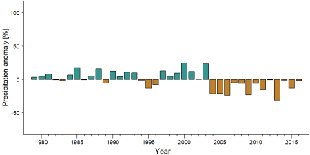
Precipitation anomaly in Souanké-Sembe Landscape -
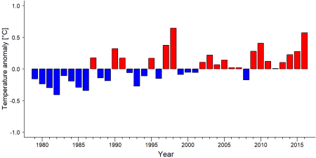
Temperature anomaly in Souanké-Sembe Landscape


External links
References
IUCN - International Union for Conservation of Nature (2014). Regional Action Plan for the Conservation of Western Lowland Gorillas and Central Chimpanzees 2015–2025. International Union for Conservation of Nature. doi:10.2305/iucn.ch.2005.ssc-rap.1.en
Kiribou, R., Tehoda, P., Chukwu, O., Bempah, G., Kühl, H. S., Ferreira, J., …, & Heinicke, S. (2024). Exposure of African ape sites to climate change impacts. PLOS Climate, 3(2), e0000345. doi:10.1371/journal.pclm.0000345
Page created by: APES Atlas Team Date: 2022-01-10