
Misotshi-Kabogo (Ngamikka Proposed National Park): Difference between revisions
No edit summary |
No edit summary |
||
| Line 220: | Line 220: | ||
= Exposure to climate change impacts = | = Exposure to climate change impacts = | ||
As part of a study on the exposure of African great ape sites to climate change impacts, Kiribou et al. | As part of a study on the exposure of African great ape sites to climate change impacts, Kiribou et al. (2024) extracted climate data and data on projected extreme climate impact events for the site. Climatological characteristics were derived from observation-based climate data provided by the Inter-Sectoral Impact Model Intercomparison Project (ISIMIP, www.isimip.org). Parameters were calculated as the average across each 30-year period. For 1981-2010, the EWEMBI dataset from ISIMIP2a was used. For the two future periods (2021-2050 and 2071-2099) ISIMIP2b climate data based on four CMIP5 global climate models were used. For future projections, two Representative Concentration Pathways (RCP) were used. RCP 2.6 is a scenario with strong mitigation measures in which global temperatures would likely rise below 2C. RCP 6.0 is a scenario with medium emissions in which global temperatures would likely rise up to 3C by 2100. For the number of days with heavy precipitation events, the 98th percentile of all precipitation days (>1mm/d) was calculated for the 1979-2013 reference period as a threshold for a heavy precipitation event. Then, for each year, the number of days above that threshold was derived. The figures on temperature and precipitation anomaly show the deviation from the mean temperature and mean precipitation for the 1979-2013 reference period. | ||
The estimated exposure to future extreme climate impact events (crop failure, drought, river flood, wildfire, tropical cyclone, and heatwave) is based on a published dataset by Lange et al. 2020 derived from ISIMIP2b data. The same global climate models and RCPs as described above were used. Within each 30-year period, the number of years with an extreme event and the average proportion of the site affected were calculated ( | The estimated exposure to future extreme climate impact events (crop failure, drought, river flood, wildfire, tropical cyclone, and heatwave) is based on a published dataset by Lange et al. 2020 derived from ISIMIP2b data. The same global climate models and RCPs as described above were used. Within each 30-year period, the number of years with an extreme event and the average proportion of the site affected were calculated (Kiribou et al. 2024). | ||
'''Table 8. Estimated past and projected climatological characteristics in Misotshi-Kabogo (Ngamikka Proposed National Park)''' | '''Table 8. Estimated past and projected climatological characteristics in Misotshi-Kabogo (Ngamikka Proposed National Park)''' | ||
Revision as of 08:17, 3 September 2026
Central Africa > Democratic Republic of the Congo > Misotshi-Kabogo (Ngamikka Proposed National Park)
Français | Português | Español | Bahasa Indonesia | Melayu
Summary
- Eastern chimpanzees (Pan troglodytes schweinfurthii) are present in Misotshi-Kabogo.
- It has been estimated that 977 (+/-252 SE) individuals occur in the site.
- The chimpanzee population trend is unknown.
- The site has a total size of 1000 km².
- Key threats to chimpanzees are artisanal gold mining and habitat encroachment.
- Conservation activities are not documented; the site is a proposed protected area.
Site characteristics
The Misotshi-Kabogo (formerly Kabobo) region of eastern Democratic Republic of Congo consists of approx. 1,000 sq km of medium altitude and montane rainforest ranging from 770-2,725 metres on the escarpment to the west of Lake Tanganyika. Few forests are left in Africa with this altitudinal range, making the area particularly important for biodiversity conservation (Plumptre et al. 2008). The total number of mammal, bird, reptile, amphibian and plant species recorded from this region number 1,605, of which 76 species are endemic to the Albertine Rift (WCS).
Table 1. Basic site information for Misotshi-Kabogo (Ngamikka Proposed National Park)
| Species | Pan troglodytes schweinfurthii |
| Area | 1,000 km² |
| Coordinates | Lat: -5.342083 , Lon: 29.151380 |
| Type of site | Proposed protected area |
| Habitat types | Subtropical/tropical moist montane forest, Grassland |
| Type of governance |
Types of sites Governance types Habitat types
Ape status
In 2007, the Wildlife Conservation Society led a team of researchers from the WCS Uganda and DRC, The Field Museum in Chicago, ICCN and WWF to survey the area; previously, it had been impossible to visit the region for more than 50 years due to rebel activity (Plumptre et al. 2008).
Table 2. Ape population estimates reported for Misotshi-Kabogo (Ngamikka Proposed National Park)
| Species | Year | Occurrence | Encounter or vistation rate (nests/km; ind/day) | Density estimate [ind./ km²] (95% CI) | Abundance estimate (95% CI) | Survey area | Sampling method | Analytical framework | Source | Comments | A.P.E.S. database ID |
|---|---|---|---|---|---|---|---|---|---|---|---|
| Pan troglodytes schweinfurthii | 2007 | 0.72-1.22 | 977.0 | Misotshi-Kabogo/Ngamikka Proposed National Park (804 km²) | Line transects | Plumptre et al. 2008 | survey effort: 133.4 km, 977 (+/-252 SE) |
Sampling methods Analytical frameworks
Threats
Compared to other areas in the Albertine Rift, signs of human impact are reportedly lower. Most impacts appear near the southern edge of the site, where people are settling and cultivating (Plumptre et al. 2008). Deeper in the forest (and at higher altitudes), the site has been impacted by artisanal gold mining. Mining in the area started many years ago; following independence in 1960, Laurent Kabila started a business of mining gold in the forest and exporting it to Tanzania to support his rebellion in the region. Mining continued throughout the 1960s and 1970s until he was removed from the forest in 1980. More recently, gold mining is carried out mostly by migrants from Bukavu and Uvira; local people do not feel that the rewards from mining make it worth the while (Plumptre et al. 2008).
Table 3. Threats to apes reported for Misotshi-Kabogo (Ngamikka Proposed National Park)
| Category | Specific threats | Threat level | Description | Year of threat |
|---|---|---|---|---|
| 2 Agriculture & aquaculture | 2.1 Annual & perennial non-timber crops | Present (unknown severity) | Cultivations in the southern edge of the site (Plumptre et al. 2008). | Ongoing (2008) |
| 3 Energy production & mining | 3.2 Mining & quarrying | Present (unknown severity) | Artisanal gold mining (Plumptre et al. 2008). | Ongoing (2008) |
| 5 Biological resource use | 5.1 Hunting & collecting terrestrial animals | Present (unknown severity) | Hunting of large mammals (ungulates and primates), although hunting of chimpanzees is a taboo in the Babembe culture. Hunting using shotguns; snares more uncommon (Plumptre et al. 2008). | Ongoing (2008) |
| 5 Biological resource use | 5.3 Logging & wood harvesting | Present (unknown severity) | Ongoing (2008) |
Conservation activities
WCS has been working with villages around the forest of Misotshi-Kabogo to delineate the boundaries of a proposed national park. The proposed Ngamikka National Park would be connected to Luama Katanga hunting reserve, together forming 4,000 sq km of natural habitat and conserving at least 1,500 chimpanzees as well as endemic species to the area (Plumptre et al. 2010, WCS).
Challenges
Table 5. Challenges reported for Misotshi-Kabogo (Ngamikka Proposed National Park)
| Challenges | Specific challenges | Source | Year(s) |
|---|---|---|---|
| Not reported |
Enablers
Table 6. Enablers reported for Misotshi-Kabogo (Ngamikka Proposed National Park)
| Enablers | Specific enablers | Source | Year(s) |
|---|---|---|---|
| 1 Site management | |||
| 2 Resources and capacity | |||
| 3 Engaged community | |||
| 4 Institutional support | |||
| 5 Ecological context | |||
| 6 Safety and stability |
Research activities
Documented behaviours
Table 7. Behaviours documented for Misotshi-Kabogo (Ngamikka Proposed National Park)
| Category | Behavior | Observation type | Prevalence | Observation dates | Source | Habituation | Species | Comment |
|---|---|---|---|---|---|---|---|---|
| Not reported |
Exposure to climate change impacts
As part of a study on the exposure of African great ape sites to climate change impacts, Kiribou et al. (2024) extracted climate data and data on projected extreme climate impact events for the site. Climatological characteristics were derived from observation-based climate data provided by the Inter-Sectoral Impact Model Intercomparison Project (ISIMIP, www.isimip.org). Parameters were calculated as the average across each 30-year period. For 1981-2010, the EWEMBI dataset from ISIMIP2a was used. For the two future periods (2021-2050 and 2071-2099) ISIMIP2b climate data based on four CMIP5 global climate models were used. For future projections, two Representative Concentration Pathways (RCP) were used. RCP 2.6 is a scenario with strong mitigation measures in which global temperatures would likely rise below 2C. RCP 6.0 is a scenario with medium emissions in which global temperatures would likely rise up to 3C by 2100. For the number of days with heavy precipitation events, the 98th percentile of all precipitation days (>1mm/d) was calculated for the 1979-2013 reference period as a threshold for a heavy precipitation event. Then, for each year, the number of days above that threshold was derived. The figures on temperature and precipitation anomaly show the deviation from the mean temperature and mean precipitation for the 1979-2013 reference period.
The estimated exposure to future extreme climate impact events (crop failure, drought, river flood, wildfire, tropical cyclone, and heatwave) is based on a published dataset by Lange et al. 2020 derived from ISIMIP2b data. The same global climate models and RCPs as described above were used. Within each 30-year period, the number of years with an extreme event and the average proportion of the site affected were calculated (Kiribou et al. 2024).
Table 8. Estimated past and projected climatological characteristics in Misotshi-Kabogo (Ngamikka Proposed National Park)
| Value | 1981-2010 | 2021-2050, RCP 2.6 | 2021-2050, RCP 6.0 | 2071-2099, RCP 2.6 | 2071-2099, RCP 6.0 |
|---|---|---|---|---|---|
| Mean temperature [C] | 21.4 | 22.5 | 22.4 | 22.6 | 24 |
| Annual precipitation [mm] | 1149 | 1167 | 1201 | 1152 | 1158 |
| Max no. consecutive dry days (per year) | 67.8 | 89.1 | 81.6 | 96.1 | 87.1 |
| No. days with heavy precipitation (per year) | 4.8 | 5.5 | 5.6 | 5 | 5.9 |
Table 9. Projected exposure of apes to extreme climate impact events in Misotshi-Kabogo (Ngamikka Proposed National Park)
| Type | No. of years with event (2021-2050, RCP 2.6) | % of site exposed (2021-2050, RCP 2.6) | No. of years with event (2021-2050, RCP 6.0) | % of site exposed (2021-2050, RCP 6.0) | No. of years with event (2070-2099, RCP 2.6) | % of site exposed (2070-2099, RCP 2.6) | No. of years with event (2070-2099, RCP 6.0) | % of site exposed (2070-2099, RCP 6.0) |
|---|---|---|---|---|---|---|---|---|
| Crop failure | 8.5 | 0.18 | 6 | 0.18 | 7.5 | 0.19 | 11 | 0.19 |
| Drought | 0 | 0 | 0 | 0 | 0 | 0 | 0 | 0 |
| Heatwave | 0 | 0 | 0 | 0 | 0 | 0 | 0 | 0 |
| River flood | 1.25 | 1.16 | 0.5 | 3.21 | 0.5 | 1.07 | 1.5 | 2.96 |
| Tropical cyclone | 0 | 0 | 0 | 0 | 0 | 0 | 0 | 0 |
| Wildfire | 30 | 1.69 | 30 | 0.98 | 29 | 1.71 | 29 | 1.13 |
-
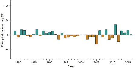
Precipitation anomaly in Misotshi-Kabogo (Ngamikka Proposed National Park) -
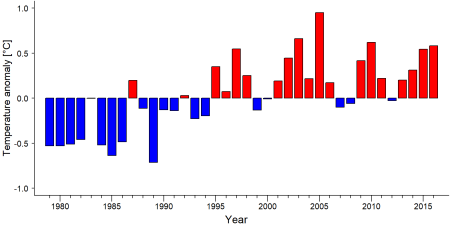
Temperature anomaly in Misotshi-Kabogo (Ngamikka Proposed National Park)


External links
References
Plumptre, A.J., Kujirakwinja, D., Matunguru, J., Kahindo, C., Kaleme, P, Marks, B., and Huhndorf M. 2008. Biodiversity surveys in the Misotshi-Kabogo and Marungu regions of eastern Democratic Republic of Congo with a focus on chimpanzees. Albertine Rift Technical Reports No. 5. https://albertinerift.wcs.org/DesktopModules/Bring2mind/DMX/API/Entries/Download?EntryId=11614&PortalId=49&DownloadMethod=attachment
Plumptre, A.J., Kujirakwinja, D., Bamba, A., and Shamavu, P. (2010). Creating the Misotshi-Kabogo Protected Area In Eastern Democratic Republic of Congo. Final Report for USFWS Project 98210 – 8– G531.
Page created by: APES Atlas Team Date: 2022-02-18