
Mont Sângbé National Park: Difference between revisions
No edit summary |
No edit summary |
||
| Line 202: | Line 202: | ||
|- | |- | ||
|2 Resources and capacity | |2 Resources and capacity | ||
|2. | |2.4 Lack of continuous/long-term funding | ||
|Beda, 2023 | |Beda, 2023 | ||
|Ongoing (2022) | |Ongoing (2022) | ||
|- | |- | ||
|2 Resources and capacity | |2 Resources and capacity | ||
|2. | |2.5 Lack of equipment/transportation | ||
|Beda, 2023 | |Beda, 2023 | ||
|Ongoing (2022) | |Ongoing (2022) | ||
Revision as of 05:23, 21 April 2026
West Africa > Côte d'Ivoire > Mont Sângbé National Park
Français | Português | Español | Bahasa Indonesia | Melayu
Summary
- Western chimpanzees (Pan troglodytes verus) are present in Mont Sângbé National Park.
- A population of 15 individuals was estimated in 2016.
- The chimpanzee population trend is decreasing.
- The site has a total size of 975.54 km².
- Key threats to chimpanzees are hunting and habitat loss due to agricultural expansion.
- Conservation activities implemented include biomonitoring.
Site characteristics
Mont Sângbé National Park is located in western Côte d’Ivoire, bordered by the Sassandra river to the east (BirdLife International 2022). The Bafing river, an affluent of the Sassandra, flows east across the southern part of the park. The park forms part of the eastern end of the highland chain that extends through Guinea and northern Liberia. The terrain is rugged, with many inselbergs and several peaks that reach over 700 m (BirdLife International 2022; Cohen, H. pers. comm. 2022). The vegetation consists mainly of dense savanna woodland with some small patches of deciduous forest as islands in the savanna or as galleries along watercourses (BirdLife International 2022).
Table 1. Basic site information for Mont Sângbé National Park
| Species | Pan troglodytes verus |
| Area | 975.54 km² |
| Coordinates | Lat: 8.013935 , Lon: -7.290896 |
| Type of site | Protected area (National Park) |
| Habitat types | Subtropical/tropical dry forest, Subtropical/tropical moist lowland forest, Savanna, Rocky areas (inland cliffs, mountain peaks) |
| Type of governance |
Types of sites Governance types Habitat types
Ape status
Reconnaissance surveys were conducted at the site in 2015 and 2016. Surveys in the southern sector of the park could not be completed due to the difficulty of the terrain. No traces of chimpanzees were found in the southern sector, but there may have been chimpanzees in the areas that were difficult to access (Cohen, H. pers. comm. 2022). North of the Bafing River appeared to be a group of about 15 individuals. Based on genetic analyses, 14 individuals were identified from over 200 faecal samples; the individuals were found to be extremely inbred (Lester et al. 2021).
Table 2. Ape population estimates reported for Mont Sângbé National Park
| Species | Year | Occurrence | Encounter or vistation rate (nests/km; ind/day) | Density estimate [ind./ km²] (95% CI) | Abundance estimate (95% CI) | Survey area | Sampling method | Analytical framework | Source | Comments | A.P.E.S. database ID |
|---|---|---|---|---|---|---|---|---|---|---|---|
| Pan troglodytes verus | 2020 | 0.023 (0.013-0.042) | 70 (40-123) | Mont Sângbé National Park | Line transects & recces | Distance sampling | Beda 2020 | ||||
| Pan troglodytes verus | 2021 | 54 (30-98) | Mont Sângbé National Park | Line transects & recces | Distance sampling | Beda et al. 2021 | |||||
| Pan troglodytes verus | 2022 | 53 (35-115) | Mont Sângbé National Park | Line transects & recces | Distance sampling | Beda 2023 | |||||
| Pan troglodytes verus | 2015-2016 | 15.0 | Mont Sângbé National Park | Reconnaissance walk | Cohen, H. pers. comm. 2022 | A maximum of 13-14 fresh nests were reported at any daily site. |
Sampling methods Analytical frameworks
Threats
The national park is surrounded by savanna and farmland, making it a geographic island with low or no connectivity to other chimpanzee populations (Cohen, H. pers. comm. 2022). Although chimpanzees are not targeted by hunters, they are killed opportunistically. Many in the local population do not have a taboo against eating chimpanzee meat (Cohen, H. pers. comm. 2022).
Table 3. Threats to apes reported for Mont Sângbé National Park
| Category | Specific threats | Threat level | Description | Year of threat |
|---|---|---|---|---|
| 11 Climate change & severe weather | 11.1 Habitat shifting & alteration | Present (unknown severity) | Climate change will likely impact the site, e.g., impact of rivers drying up or diminishing sources of permanent rivers, as well as other effects due to temperature and rainfall changes (Cohen, H. pers. comm. 2022). | Ongoing (2022) |
| 2 Agriculture & aquaculture | 2.1 Annual & perennial non-timber crops | High (more than 70% of population affected) | Widespread destruction of the landscape for cocoa plantations in particular, observed during a 2016 survey (Cohen, H. pers. comm. 2022). | 2016-Ongoing (2022) |
| 2 Agriculture & aquaculture | 2.3 Livestock farming & ranching | High (more than 70% of population affected) | Cattle pasturing; herders enter the savanna/dry forest areas of the park. Grass is burnt annually, and this wildfire can penetrate quite deep into the wet forest (Cohen, H. pers. comm. 2022). | Ongoing (2022) |
| 5 Biological resource use | 5.1 Hunting & collecting terrestrial animals | Medium (30-70% of population affected) | Chimpanzees are not targeted for hunting in the park, but have been killed there when the opportunity has presented itself (Cohen, H. pers. comm. 2022). The comparison of the recorded aggression indices during this phase with those from previous phases (2017 to 2021) suggests that poaching is the main threat to the PNMS. A comparison of the data from 2017 to 2022 shows a decline in aggression indices (Beda et al. 2023).
|
2017-Ongoing (2022) |
Conservation activities
Table 4. Conservation activities reported for Mont Sângbé National Park
| Category | Specific activity | Description | Implementing organization(s) | Year of activity |
|---|---|---|---|---|
| 2 Counter-wildlife crime | 2.11 Implement monitoring surveillance strategies (e.g., SMART) or use monitoring data to improve effectiveness of patrols | In the Mont Sangbé National Park, ecological monitoring is conducted annually by the Western Zone Directorate with support from technical and financial partners. This monitoring focuses on a set of animal species identified as conservation targets and the factors influencing their distribution. The goal of the program for the 2020-2030 period, as outlined in the Park's Management and Development Plan, is to "Contribute to improving the management of the MSNP based on knowledge derived from the results of ecological monitoring and research." The program centers around assessing the conservation status of the SMNP based on the ecological monitoring findings and capitalizing on research outcomes (Beda et al. 2021). | Office Ivoirien des Parcs et Réserves | 2017-Ongoing (2022) |
| 5 Protection & restoration | 5.2 Legally protect ape habitat | The site is a National Park. | 1976-Ongoing (2026) |
Challenges
Table 5. Challenges reported for Mont Sângbé National Park
| Challenges | Specific challenges | Source | Year(s) |
|---|---|---|---|
| 2 Resources and capacity | 2.1 Lack of capacity/training | Beda, 2023 | Ongoing (2022) |
| 2 Resources and capacity | 2.4 Lack of continuous/long-term funding | Beda, 2023 | Ongoing (2022) |
| 2 Resources and capacity | 2.5 Lack of equipment/transportation | Beda, 2023 | Ongoing (2022) |
Enablers
Table 6. Enablers reported for Mont Sângbé National Park
| Enablers | Specific enablers | Source | Year(s) |
|---|---|---|---|
| 2 Resources and capacity | 2.4 Adequate data to inform and evaluate conservation actions | Beda 2023 | Ongoing (2022) |
| 4 Institutional support | 4.1 Effective legislation and law enforcement | Beda 2023 | Ongoing (2022) |
| 1 Site management | |||
| 3 Engaged community | |||
| 5 Ecological context | |||
| 6 Safety and stability |
Research activities
The site was surveyed as part of the Pan African Programme (PanAf).
Documented behaviours
Table 7. Behaviours documented for Mont Sângbé National Park
| Category | Behavior | Observation type | Prevalence | Observation dates | Source | Habituation | Species | Comment |
|---|---|---|---|---|---|---|---|---|
| Not reported |
Exposure to climate change impacts
As part of a study on the exposure of African great ape sites to climate change impacts, Kiribou et al. subm. extracted climate data and data on projected extreme climate impact events for the site. Climatological characteristics were derived from observation-based climate data provided by the Inter-Sectoral Impact Model Intercomparison Project (ISIMIP, www.isimip.org). Parameters were calculated as the average across each 30-year period. For 1981-2010, the EWEMBI dataset from ISIMIP2a was used. For the two future periods (2021-2050 and 2071-2099) ISIMIP2b climate data based on four CMIP5 global climate models were used. For future projections, two Representative Concentration Pathways (RCP) were used. RCP 2.6 is a scenario with strong mitigation measures in which global temperatures would likely rise below 2C. RCP 6.0 is a scenario with medium emissions in which global temperatures would likely rise up to 3C by 2100. For the number of days with heavy precipitation events, the 98th percentile of all precipitation days (>1mm/d) was calculated for the 1979-2013 reference period as a threshold for a heavy precipitation event. Then, for each year, the number of days above that threshold was derived. The figures on temperature and precipitation anomaly show the deviation from the mean temperature and mean precipitation for the 1979-2013 reference period.
The estimated exposure to future extreme climate impact events (crop failure, drought, river flood, wildfire, tropical cyclone, and heatwave) is based on a published dataset by Lange et al. 2020 derived from ISIMIP2b data. The same global climate models and RCPs as described above were used. Within each 30-year period, the number of years with an extreme event and the average proportion of the site affected were calculated (see Kiribou et al. subm. for details).
Table 8. Estimated past and projected climatological characteristics in Mont Sângbé National Park
| Value | 1981-2010 | 2021-2050, RCP 2.6 | 2021-2050, RCP 6.0 | 2071-2099, RCP 2.6 | 2071-2099, RCP 6.0 |
|---|---|---|---|---|---|
| Mean temperature [C] | 25.1 | 26.3 | 26.3 | 26.4 | 27.6 |
| Annual precipitation [mm] | 1588 | 1605 | 1652 | 1617 | 1694 |
| Max no. consecutive dry days (per year) | 34.7 | 34 | 35.2 | 35.5 | 36.6 |
| No. days with heavy precipitation (per year) | 5.5 | 6 | 6.2 | 6.1 | 8 |
Table 9. Projected exposure of apes to extreme climate impact events in Mont Sângbé National Park
| Type | No. of years with event (2021-2050, RCP 2.6) | % of site exposed (2021-2050, RCP 2.6) | No. of years with event (2021-2050, RCP 6.0) | % of site exposed (2021-2050, RCP 6.0) | No. of years with event (2070-2099, RCP 2.6) | % of site exposed (2070-2099, RCP 2.6) | No. of years with event (2070-2099, RCP 6.0) | % of site exposed (2070-2099, RCP 6.0) |
|---|---|---|---|---|---|---|---|---|
| Crop failure | 2 | 1.87 | 1 | 1.48 | 2.5 | 1.87 | 9 | 1.87 |
| Drought | 0 | 0 | 0 | 0 | 0 | 0 | 0 | 0 |
| Heatwave | 1.5 | 100 | 1.5 | 100 | 3 | 100 | 1.5 | 100 |
| River flood | 1.25 | 0.46 | 1.5 | 2.78 | 2.25 | 1.94 | 4.5 | 3.09 |
| Tropical cyclone | 0 | 0 | 0 | 0 | 0 | 0 | 0 | 0 |
| Wildfire | 30 | 0.71 | 30 | 0.8 | 29 | 0.82 | 29 | 0.94 |
-
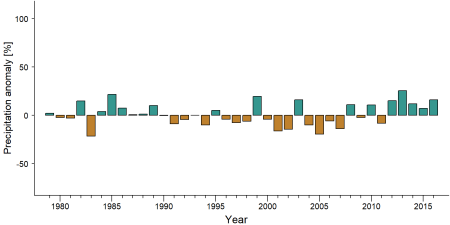
Precipitation anomaly in Mont Sângbé National Park -
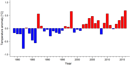
Temperature anomaly in Mont Sângbé National Park


External links
References
BirdLife International (2022) Important Bird Areas factsheet: Sangbe Mountain National Park. Downloaded from http://www.birdlife.org on 27/06/2022.
Lester, J. D., Vigilant, L., Gratton, P., McCarthy, M. S., Barratt, C. D., Dieguez, P., ... & Arandjelovic, M. (2021). Recent genetic connectivity and clinal variation in chimpanzees. Communications biology, 4(1), 1-11.
Beda, A. A., N’dri, K. P., Zannou, M. G., & Tondossama, A. (2021). Etat de conservation du Parc national du Mont Sangbé : Résultats du suivi écologique, Phase 5. Office Ivoirien des Parcs et Réserves/Direction de Zone Ouest. Man, Côte d’Ivoire. 36p.
Beda, A. A. (2023). Rapport suivi écologique du Parc National du Mont Sangbé 2022: Suivi écologique phase 6, version du 19. 04.2023. Office Ivoirien des Parcs et Réserves/Direction de Zone Ouest. Man, Côte d’Ivoire. 63p.
Beda, A. A. (2020). Etat de conservation du Parc National du Mont Sangbé 2022: Rapport de suivi écologique Phase 4. Office Ivoirien des Parcs et Réserves/Direction de Zone Ouest. Man, Côte d’Ivoire. 45p.
Page created by: Heather Cohen & APES Atlas Team Date: 2022-07-04
Page updated by: Diorne Zausa Date: 2024-11-30