
Mount Nimba Strict Nature Reserve (Guinea): Difference between revisions
No edit summary |
No edit summary |
||
| Line 18: | Line 18: | ||
Mount Nimba Strict Nature Reserve is located in the Nimba Mountains at the tri-national border of Guinea, Liberia and Côte d’Ivoire. It was designated a Strict Nature Reserve in 1944 (IUCN Category Ia) and is transboundary with Mount Nimba Integral Reserve (Côte d’Ivoire) and East Nimba Nature Reserve (Liberia, [https://www.protectedplanet.net/mount-nimba-strict-nature-reserve UNEP-WCMC and IUCN 2018]). Unlike other protected areas in Guinea, Nimba was managed the Museum National d’Histoire Naturelle (Paris) and the Institut Français d’Afrique Noire (Dakar) after its creation (Brugière & Kormos 2009, Garnier & Martinez 2011). Consequently, the site as a long history of scientific studies (Garnier & Martinez 2011). <br> | Mount Nimba Strict Nature Reserve is located in the Nimba Mountains at the tri-national border of Guinea, Liberia and Côte d’Ivoire. It was designated a Strict Nature Reserve in 1944 (IUCN Category Ia) and is transboundary with Mount Nimba Integral Reserve (Côte d’Ivoire) and East Nimba Nature Reserve (Liberia, [https://www.protectedplanet.net/mount-nimba-strict-nature-reserve UNEP-WCMC and IUCN 2018]). Unlike other protected areas in Guinea, Nimba was managed the Museum National d’Histoire Naturelle (Paris) and the Institut Français d’Afrique Noire (Dakar) after its creation (Brugière & Kormos 2009, Garnier & Martinez 2011). Consequently, the site as a long history of scientific studies (Garnier & Martinez 2011). <br> | ||
The reserve is now managed by the Centre for the Management of the Environment of Mount Nimba-Simandou (‘Centre National de Gestion de l’Environnement des Monts Nimba et Simandou‘, CEGENS) under the Ministry of Environment, Water and Forests and Sustainable Development, and fulfills administrative as well as scientific responsibilities (UNESCO 2018a). <br> | The reserve is now managed by the Centre for the Management of the Environment of Mount Nimba-Simandou (‘Centre National de Gestion de l’Environnement des Monts Nimba et Simandou‘, CEGENS) under the Ministry of Environment, Water and Forests and Sustainable Development, and fulfills administrative as well as scientific responsibilities ([[#R01303|UNESCO 2018a]]). <br> | ||
The Nimba Mountains are a chain of mountains stretching across 40 km with the highest peak being Mount Nimba with 1,752m (Kormos & Boesch 2003). The area is characterized by a high plant and animal diversity and a high rate of endemism. The terrain is steep and the source if several rivers (Granier 2008). The habitat is moist forest up to 1,000 m altitude, but also includes grassland and wooded savanna (UNESCO 2018a). Due to strong seasonality and the abrupt change in altitude a variety of microclimates exist contributing to the high biodiversity (UNESCO 2018a). The most well-known endemic species are the Micropotamogale of Mount Nimba (''Micropotamogale lamottei'', a shrew), the viviparous toad of Mount Nimba (''Nimbaphrynoides occidentalis'') (UNESCO 2018a). In total, more than 317 vertebrate species, including 107 mammal species, more than 2,500 invertebrate species, and 2,000 plant species have been described (UNESCO 2018). <br> | The Nimba Mountains are a chain of mountains stretching across 40 km with the highest peak being Mount Nimba with 1,752m ([[#R01297|Kormos & Boesch 2003]]). The area is characterized by a high plant and animal diversity and a high rate of endemism. The terrain is steep and the source if several rivers ([[#R01284|Granier 2008]]). The habitat is moist forest up to 1,000 m altitude, but also includes grassland and wooded savanna ([[#R01303|UNESCO 2018a]]). Due to strong seasonality and the abrupt change in altitude a variety of microclimates exist contributing to the high biodiversity ([[#R01303|UNESCO 2018a]]). The most well-known endemic species are the Micropotamogale of Mount Nimba (''Micropotamogale lamottei'', a shrew), the viviparous toad of Mount Nimba (''Nimbaphrynoides occidentalis'') ([[#R01303|UNESCO 2018a]]). In total, more than 317 vertebrate species, including 107 mammal species, more than 2,500 invertebrate species, and 2,000 plant species have been described (UNESCO 2018). <br> | ||
Mount Nimba Strict Nature Reserve has been a UNESCO World Heritage Site since 1981 and the only one in Guinea ([http://whc.unesco.org/en/list/155 UNESCO 2018]). It covers both Guinea (125.4 km2) and Côte d’Ivoire (50 km2). However, due to the threat of iron mining and the arrival of a large number of refugees from Liberia it has been listed as World Heritage in Danger since 1992 (UNESCO 2018a). | Mount Nimba Strict Nature Reserve has been a UNESCO World Heritage Site since 1981 and the only one in Guinea ([http://whc.unesco.org/en/list/155 UNESCO 2018]). It covers both Guinea (125.4 km2) and Côte d’Ivoire (50 km2). However, due to the threat of iron mining and the arrival of a large number of refugees from Liberia it has been listed as World Heritage in Danger since 1992 ([[#R01303|UNESCO 2018a]]). | ||
Since 1980 the Guinean part of the Nimba Mountains is also part of the Mont Nimba Biosphere Reserve that also includes Déré forest and Bossou hills ([http://www.unesco.org/new/en/natural-sciences/environment/ecological-sciences/biosphere-reserves/africa/guinea/mont-nimba/ UNESCO 2011]). <br> | Since 1980 the Guinean part of the Nimba Mountains is also part of the Mont Nimba Biosphere Reserve that also includes Déré forest and Bossou hills ([http://www.unesco.org/new/en/natural-sciences/environment/ecological-sciences/biosphere-reserves/africa/guinea/mont-nimba/ UNESCO 2011]). <br> | ||
Even though the avifauna is not well studied in the Guinean part of the Nimba Mountains, its diversity is assumed to be similar to the Liberian part of the mountain range, and the area is consequently recognized as an Important Bird Area ([http://datazone.birdlife.org/site/factsheet/monts-nimba-(part-of-mount-nimba-transboundary-aze)-iba-guinea BirdLife International 2018a]). <br> | Even though the avifauna is not well studied in the Guinean part of the Nimba Mountains, its diversity is assumed to be similar to the Liberian part of the mountain range, and the area is consequently recognized as an Important Bird Area ([http://datazone.birdlife.org/site/factsheet/monts-nimba-(part-of-mount-nimba-transboundary-aze)-iba-guinea BirdLife International 2018a]). <br> | ||
Unlike other protected areas in Guinea, Nimba was managed the Museum National d’Histoire Naturelle (Paris) and the Institut Français d’Afrique Noire (Dakar) after its creation (Brugière & Kormos 2009, Garnier & Martinez 2011). Consequently, the site as a long history of scientific studies (Garnier & Martinez 2011). <br> | Unlike other protected areas in Guinea, Nimba was managed the Museum National d’Histoire Naturelle (Paris) and the Institut Français d’Afrique Noire (Dakar) after its creation (Brugière & Kormos 2009, Garnier & Martinez 2011). Consequently, the site as a long history of scientific studies (Garnier & Martinez 2011). <br> | ||
The reserve is now managed by the Centre for the Management of the Environment of Mount Nimba-Simandou (‘Centre National de Gestion de l’Environnement des Monts Nimba et Simandou‘, CEGENS) under the Ministry of Environment, Water and Forests and Sustainable Development, and fulfills administrative as well as scientific responsibilities (UNESCO 2018a). <br> | The reserve is now managed by the Centre for the Management of the Environment of Mount Nimba-Simandou (‘Centre National de Gestion de l’Environnement des Monts Nimba et Simandou‘, CEGENS) under the Ministry of Environment, Water and Forests and Sustainable Development, and fulfills administrative as well as scientific responsibilities ([[#R01303|UNESCO 2018a]]). <br> | ||
The Nimba Mountains are a chain of mountains stretching across 40 km with the highest peak being Mount Nimba with 1,752m (Kormos & Boesch 2003). The area is characterized by a high plant and animal diversity and a high rate of endemism. The terrain is steep and the source if several rivers (Granier 2008). The habitat is moist forest up to 1,000 m altitude, but also includes grassland and wooded savanna (UNESCO 2018a). Due to strong seasonality and the abrupt change in altitude a variety of microclimates exist contributing to the high biodiversity (UNESCO 2018a). The most well-known endemic species are the Micropotamogale of Mount Nimba (''Micropotamogale lamottei'', a shrew), the viviparous toad of Mount Nimba (''Nimbaphrynoides occidentalis'') (UNESCO 2018a). In total, more than 317 vertebrate species, including 107 mammal species, more than 2,500 invertebrate species, and 2,000 plant species have been described (UNESCO 2018). <br> | The Nimba Mountains are a chain of mountains stretching across 40 km with the highest peak being Mount Nimba with 1,752m ([[#R01297|Kormos & Boesch 2003]]). The area is characterized by a high plant and animal diversity and a high rate of endemism. The terrain is steep and the source if several rivers ([[#R01284|Granier 2008]]). The habitat is moist forest up to 1,000 m altitude, but also includes grassland and wooded savanna ([[#R01303|UNESCO 2018a]]). Due to strong seasonality and the abrupt change in altitude a variety of microclimates exist contributing to the high biodiversity ([[#R01303|UNESCO 2018a]]). The most well-known endemic species are the Micropotamogale of Mount Nimba (''Micropotamogale lamottei'', a shrew), the viviparous toad of Mount Nimba (''Nimbaphrynoides occidentalis'') ([[#R01303|UNESCO 2018a]]). In total, more than 317 vertebrate species, including 107 mammal species, more than 2,500 invertebrate species, and 2,000 plant species have been described (UNESCO 2018). <br> | ||
Mount Nimba Strict Nature Reserve has been a UNESCO World Heritage Site since 1981 and the only one in Guinea ([http://whc.unesco.org/en/list/155 UNESCO 2018]). It covers both Guinea (125.4 km2) and Côte d’Ivoire (50 km2). However, due to the threat of iron mining and the arrival of a large number of refugees from Liberia it has been listed as World Heritage in Danger since 1992 (UNESCO 2018a). | Mount Nimba Strict Nature Reserve has been a UNESCO World Heritage Site since 1981 and the only one in Guinea ([http://whc.unesco.org/en/list/155 UNESCO 2018]). It covers both Guinea (125.4 km2) and Côte d’Ivoire (50 km2). However, due to the threat of iron mining and the arrival of a large number of refugees from Liberia it has been listed as World Heritage in Danger since 1992 ([[#R01303|UNESCO 2018a]]). | ||
Since 1980 the Guinean part of the Nimba Mountains is also part of the Mont Nimba Biosphere Reserve that also includes Déré forest and Bossou hills ([http://www.unesco.org/new/en/natural-sciences/environment/ecological-sciences/biosphere-reserves/africa/guinea/mont-nimba/ UNESCO 2011]). <br> | Since 1980 the Guinean part of the Nimba Mountains is also part of the Mont Nimba Biosphere Reserve that also includes Déré forest and Bossou hills ([http://www.unesco.org/new/en/natural-sciences/environment/ecological-sciences/biosphere-reserves/africa/guinea/mont-nimba/ UNESCO 2011]). <br> | ||
Even though the avifauna is not well studied in the Guinean part of the Nimba Mountains, its diversity is assumed to be similar to the Liberian part of the mountain range, and the area is consequently recognized as an Important Bird Area ([http://datazone.birdlife.org/site/factsheet/monts-nimba-(part-of-mount-nimba-transboundary-aze)-iba-guinea BirdLife International 2018a]). | Even though the avifauna is not well studied in the Guinean part of the Nimba Mountains, its diversity is assumed to be similar to the Liberian part of the mountain range, and the area is consequently recognized as an Important Bird Area ([http://datazone.birdlife.org/site/factsheet/monts-nimba-(part-of-mount-nimba-transboundary-aze)-iba-guinea BirdLife International 2018a]). | ||
| Line 55: | Line 55: | ||
= Ape status = | = Ape status = | ||
Surveys in different parts of the Nimba Mountains confirmed the presence of western chimpanzees (Sugiyama 1995, Shimada 2001). From the beginning these surveys were also aimed to study chimpanzee behavior, such as nesting behavior and tool-use behavior (details below). In the Regional Conservation Action Plan for western chimpanzees in 2003 the Nimba Mountains were identified as an ‘Exceptionally Important Priority Area’ (Kormos & Boesch 2003). Detailed surveys on chimpanzee density distribution were conducted by Nicolas Granier during multiple surveys after 2006 that focused on the eastern part of the protected area and the southern slope of Mount Nimba (Granier 2011, Granier et al. 2014). A transect survey conducted by the Wild Chimpanzee Foundation estimated the chimpanzee population in the reserve at around 166 individuals (WCF 2012). | Surveys in different parts of the Nimba Mountains confirmed the presence of western chimpanzees ([[#R01301|Sugiyama 1995]], Shimada 2001). From the beginning these surveys were also aimed to study chimpanzee behavior, such as nesting behavior and tool-use behavior (details below). In the Regional Conservation Action Plan for western chimpanzees in 2003 the Nimba Mountains were identified as an ‘Exceptionally Important Priority Area’ ([[#R01297|Kormos & Boesch 2003]]). Detailed surveys on chimpanzee density distribution were conducted by Nicolas Granier during multiple surveys after 2006 that focused on the eastern part of the protected area and the southern slope of Mount Nimba ([[#R01285|Granier 2011]], [[#R01286|Granier et al. 2014]]). A transect survey conducted by the Wild Chimpanzee Foundation estimated the chimpanzee population in the reserve at around 166 individuals ([[#R01306|WCF 2012]]). | ||
Since 1976, several surveys have been conducted in the Seringbara region by Sugiyama, who visited the area at least four times to interview the local population on chimpanzees, suggesting chimpanzees were present in the area. During his visits he also did two field surveys of the area (Shimada 2000). Shimada confirmed the presence of chimpanzees by recorded vocalizations and the presence of nests in 1999 (Shimada 2000). While it was at first thought that chimpanzees use this area only seasonally, more systematic surveys in 2000 and 2001 established the presence of at least one chimpanzee community (Humle & Matsuzawa 2001). Long-term chimpanzee research has been ongoing at the Seringbara study site since 2003 on the Guinean side of the Nimba Mountains (Koops 2011). The Seringbara study site is on the western side of the Nimba Mountains, in the foothills adjacent to the small village of Seringbara in south-eastern Guinea (7° 37’50.0”N, 8° 27’44.7”W). Since 2003, Kathelijne Koops has directed research at the Seringbara study site and researchers and field assistants have maintained a near-constant presence at the site. The study population remains only partly habituated to human observers due to the extremely rugged nature of the terrain. For more information on the study site, see Koops (2011), Koops et al (2007; 2010; 2012a, b; 2013; 2015, 2019) and Fitzgerald et al. (2018). | Since 1976, several surveys have been conducted in the Seringbara region by Sugiyama, who visited the area at least four times to interview the local population on chimpanzees, suggesting chimpanzees were present in the area. During his visits he also did two field surveys of the area ([[#R01300|Shimada 2000]]). Shimada confirmed the presence of chimpanzees by recorded vocalizations and the presence of nests in 1999 ([[#R01300|Shimada 2000]]). While it was at first thought that chimpanzees use this area only seasonally, more systematic surveys in 2000 and 2001 established the presence of at least one chimpanzee community (Humle & Matsuzawa 2001). Long-term chimpanzee research has been ongoing at the Seringbara study site since 2003 on the Guinean side of the Nimba Mountains ([[#R01296|Koops 2011]]). The Seringbara study site is on the western side of the Nimba Mountains, in the foothills adjacent to the small village of Seringbara in south-eastern Guinea (7° 37’50.0”N, 8° 27’44.7”W). Since 2003, Kathelijne Koops has directed research at the Seringbara study site and researchers and field assistants have maintained a near-constant presence at the site. The study population remains only partly habituated to human observers due to the extremely rugged nature of the terrain. For more information on the study site, see [[#R01296|Koops (2011)]], [[#R01289|Koops et al (2007]]; 2010; 2012a, b; 2013; 2015, 2019) and [[#R01283|Fitzgerald et al. (2018)]]. | ||
| Line 83: | Line 83: | ||
|Line transects & recces | |Line transects & recces | ||
| | | | ||
|Granier et al. 2014 | |[[#R01286|Granier et al. 2014]] | ||
|Total survey effort: 78.21 km; combination of line transect and reconnaissance survey, abundance and density estimate only based on transects (i.e., 12.5 km) | |Total survey effort: 78.21 km; combination of line transect and reconnaissance survey, abundance and density estimate only based on transects (i.e., 12.5 km) | ||
| | | | ||
| Line 96: | Line 96: | ||
|Line transects | |Line transects | ||
| | | | ||
|WCF 2012 | |[[#R01306|WCF 2012]] | ||
|Total survey effort: 59.4 km | |Total survey effort: 59.4 km | ||
| | |GIN0002, GIN0010, GIN0016, GIN0020, GIN0023, GIN0024, GIN0025, GIN0027, GIN0029, GIN0036, GIN0069 | ||
|- | |- | ||
|''Pan troglodytes verus'' | |''Pan troglodytes verus'' | ||
| Line 109: | Line 109: | ||
|Line transects | |Line transects | ||
| | | | ||
|Koops 2011 | |[[#R01296|Koops 2011]] | ||
| | | | ||
| | | | ||
| Line 122: | Line 122: | ||
|Line transects & recces | |Line transects & recces | ||
| | | | ||
|Granier 2011 | |[[#R01285|Granier 2011]] | ||
|Total survey effort: 350 km; combination of line transect, reconnaissance survey and scouting surveys | |Total survey effort: 350 km; combination of line transect, reconnaissance survey and scouting surveys | ||
| | | | ||
| Line 161: | Line 161: | ||
|Reconnaissance walk | |Reconnaissance walk | ||
| | | | ||
|Sugiyama 1995 | |[[#R01301|Sugiyama 1995]] | ||
|Reconnaissance survey | |Reconnaissance survey | ||
| | | | ||
| Line 174: | Line 174: | ||
|Reconnaissance walk | |Reconnaissance walk | ||
| | | | ||
|Shimada 2000 | |[[#R01300|Shimada 2000]] | ||
|Reconnaissance survey | |Reconnaissance survey | ||
| | | | ||
| Line 187: | Line 187: | ||
|Reconnaissance walk | |Reconnaissance walk | ||
| | | | ||
|Shimada 2000 | |[[#R01300|Shimada 2000]] | ||
|Reconnaissance survey | |Reconnaissance survey | ||
| | | | ||
| Line 200: | Line 200: | ||
|Unknown | |Unknown | ||
| | | | ||
|Shimada 2000 | |[[#R01300|Shimada 2000]] | ||
| | | | ||
| | | | ||
| Line 211: | Line 211: | ||
Since 1992 Mount Nimba Strict Nature Reserve is listed as a ‘World Heritage in Danger’ because of plans to mine iron ore inside the reserve and an increase in anthropogenic pressure due to the arrival of refugees from Liberia (UNESCO 2018). Insufficient institutional structure was also reported as a threat (UNESCO 2018). As a result the boundary of the reserve were changed by the World Heritage Committee in 1993 and 15.5 km2 were degazetted so that mining operations could take place (Brugière & Kormos 2009). | Since 1992 Mount Nimba Strict Nature Reserve is listed as a ‘World Heritage in Danger’ because of plans to mine iron ore inside the reserve and an increase in anthropogenic pressure due to the arrival of refugees from Liberia (UNESCO 2018). Insufficient institutional structure was also reported as a threat (UNESCO 2018). As a result the boundary of the reserve were changed by the World Heritage Committee in 1993 and 15.5 km2 were degazetted so that mining operations could take place (Brugière & Kormos 2009). | ||
Population density is high in the area around the reserve, also as consequence of mining activities in the Nimba Mountains. Consequently, poaching, wood extraction, land conversion to agriculture and cattle grazing using fires, and harvesting of medicinal plants is very prevalent across the area (Shimada 2000, WCF 2012, BirdLife International 2018b, UNESCO 2018a). In a nation-wide survey across 12 sites in Guinea, the Wild Chimpanzee Foundation concluded that Nimba was the most threatened site with 3.94 signs of human activity per km (WCF 2012). The most prevalent threat was poaching (2.74 signs/km), followed by agriculture, and wood extraction (WCF 2012). Agricultural activities have been on-going for decades especially in the northern part close to Seringbara and around Thuo towards the Liberian border (WCF 2012). | Population density is high in the area around the reserve, also as consequence of mining activities in the Nimba Mountains. Consequently, poaching, wood extraction, land conversion to agriculture and cattle grazing using fires, and harvesting of medicinal plants is very prevalent across the area ([[#R01300|Shimada 2000]], [[#R01306|WCF 2012]], [[#R01281|BirdLife International 2018b]], [[#R01303|UNESCO 2018a]]). In a nation-wide survey across 12 sites in Guinea, the Wild Chimpanzee Foundation concluded that Nimba was the most threatened site with 3.94 signs of human activity per km ([[#R01306|WCF 2012]]). The most prevalent threat was poaching (2.74 signs/km), followed by agriculture, and wood extraction ([[#R01306|WCF 2012]]). Agricultural activities have been on-going for decades especially in the northern part close to Seringbara and around Thuo towards the Liberian border ([[#R01306|WCF 2012]]). | ||
According to the World Heritage Centre, the Guinean government arranged for all mining operations to halt in the reserve and that mining permits had been withdrawn (UNESCO 2018b). However, mining will commence in the mining enclave, a part of the World Heritage Site that has been declassified. The World Heritage Center concluded that provided information was ambiguous, and that Environmental and Social Impact Assessments had not yet been implemented by mining companies or did not confirm to international standards (UNESCO 2018b). In addition, there are plans to tarmac a road from Lola (Guinea) to Danané (Côte d’Ivoire) that would pass by Mount Nimba and likely negatively impact biodiversity due to pollution, increased poaching and illegal logging (UNESCO 2018b). | According to the World Heritage Centre, the Guinean government arranged for all mining operations to halt in the reserve and that mining permits had been withdrawn ([[#R01304|UNESCO 2018b]]). However, mining will commence in the mining enclave, a part of the World Heritage Site that has been declassified. The World Heritage Center concluded that provided information was ambiguous, and that Environmental and Social Impact Assessments had not yet been implemented by mining companies or did not confirm to international standards ([[#R01304|UNESCO 2018b]]). In addition, there are plans to tarmac a road from Lola (Guinea) to Danané (Côte d’Ivoire) that would pass by Mount Nimba and likely negatively impact biodiversity due to pollution, increased poaching and illegal logging ([[#R01304|UNESCO 2018b]]). | ||
'''Table 3. Threats to apes reported for Mount Nimba Strict Nature Reserve (Guinea)''' | '''Table 3. Threats to apes reported for Mount Nimba Strict Nature Reserve (Guinea)''' | ||
| Line 226: | Line 226: | ||
|2.1 Annual & perennial non-timber crops | |2.1 Annual & perennial non-timber crops | ||
|Medium (30-70% of population affected) | |Medium (30-70% of population affected) | ||
|Agricultural activities especially in the northern part around Seringbara and towards the border with Liberia (METT 2009, WCF 2012). | |Agricultural activities especially in the northern part around Seringbara and towards the border with Liberia ([[#R01298|METT 2009]], [[#R01306|WCF 2012]]). | ||
|2009-Ongoing (2012) | |2009-Ongoing (2012) | ||
|- | |- | ||
| Line 232: | Line 232: | ||
|2.3 Livestock farming & ranching | |2.3 Livestock farming & ranching | ||
|Present (unknown severity) | |Present (unknown severity) | ||
|Present (METT 2009, UNESCO 2018b), level of threat not known. | |Present ([[#R01298|METT 2009]], [[#R01304|UNESCO 2018b]]), level of threat not known. | ||
|Ongoing (2018) | |Ongoing (2018) | ||
|- | |- | ||
| Line 238: | Line 238: | ||
|3.2 Mining & quarrying | |3.2 Mining & quarrying | ||
|Present (unknown severity) | |Present (unknown severity) | ||
|Exploration for iron ore, activities seem to have ceased, but current threat level not clear (METT 2009, UNESCO 2018b). | |Exploration for iron ore, activities seem to have ceased, but current threat level not clear ([[#R01298|METT 2009]], [[#R01304|UNESCO 2018b]]). | ||
|2009-Ongoing (2018) | |2009-Ongoing (2018) | ||
|- | |- | ||
| Line 244: | Line 244: | ||
|4.1 Roads & railroads | |4.1 Roads & railroads | ||
|Present (unknown severity) | |Present (unknown severity) | ||
|Tarmacking of a road passing by the reserve in planning and would reinforce anthropogenic pressures such as poaching and illegal wood extraction (UNESCO 2018b), signs of paths inside reserve (WCF 2012). | |Tarmacking of a road passing by the reserve in planning and would reinforce anthropogenic pressures such as poaching and illegal wood extraction ([[#R01304|UNESCO 2018b]]), signs of paths inside reserve ([[#R01306|WCF 2012]]). | ||
|2012-Ongoing (2018) | |2012-Ongoing (2018) | ||
|- | |- | ||
| Line 250: | Line 250: | ||
|5.1 Hunting & collecting terrestrial animals | |5.1 Hunting & collecting terrestrial animals | ||
|High (more than 70% of population affected) | |High (more than 70% of population affected) | ||
|Most prevalent sign of human activity inside the reserve (WCF 2012), also confirmed by BirdLife International 2018b, METT 2009, Shimada 2000, UNESCO 2018b. | |Most prevalent sign of human activity inside the reserve ([[#R01306|WCF 2012]]), also confirmed by [[#R01281|BirdLife International 2018b]], [[#R01298|METT 2009]], [[#R01300|Shimada 2000]], [[#R01304|UNESCO 2018b]]. | ||
|2000-Ongoing (2018) | |2000-Ongoing (2018) | ||
|- | |- | ||
| Line 256: | Line 256: | ||
|5.2 Gathering terrestrial plants | |5.2 Gathering terrestrial plants | ||
|Medium (30-70% of population affected) | |Medium (30-70% of population affected) | ||
|Collection of medicinal plants (BirdLife International 2018b) | |Collection of medicinal plants ([[#R01281|BirdLife International 2018b]]) | ||
|Ongoing (2018) | |Ongoing (2018) | ||
|- | |- | ||
| Line 262: | Line 262: | ||
|5.3 Logging & wood harvesting | |5.3 Logging & wood harvesting | ||
|Medium (30-70% of population affected) | |Medium (30-70% of population affected) | ||
|Wood extraction (WCF 2012). | |Wood extraction ([[#R01306|WCF 2012]]). | ||
|Ongoing (2012) | |Ongoing (2012) | ||
|- | |- | ||
| Line 268: | Line 268: | ||
|7.1 Fire & fire suppression | |7.1 Fire & fire suppression | ||
|Medium (30-70% of population affected) | |Medium (30-70% of population affected) | ||
|Fires used to clear land for agricultural and cattle grazing (METT 2009, UNESCO 2018b, WCF 2012). | |Fires used to clear land for agricultural and cattle grazing ([[#R01298|METT 2009]], [[#R01304|UNESCO 2018b]], [[#R01306|WCF 2012]]). | ||
|2009-Ongoing (2018) | |2009-Ongoing (2018) | ||
|- | |- | ||
| Line 282: | Line 282: | ||
= Conservation activities = | = Conservation activities = | ||
The governmental unit responsible for the administration of the reserve is the Centre for the Management of the Environment of Mount Nimba-Simandou (CEGENS) under the Ministry of Environment, Water and Forests and Sustainable Development, and fulfills administrative as well as scientific responsibilities (UNESCO 2018a). | The governmental unit responsible for the administration of the reserve is the Centre for the Management of the Environment of Mount Nimba-Simandou (CEGENS) under the Ministry of Environment, Water and Forests and Sustainable Development, and fulfills administrative as well as scientific responsibilities ([[#R01303|UNESCO 2018a]]). | ||
The project ‘Ministry of Environment, Water and Forests and Sustainable Development’ by Fauna & Flora International and funded by the Darwin Initiative established a transboundary biodiversity governance platform with the aim to compile data, build capacity and improve stakeholder collaboration (2009 -20012, Darwin Nimba Project). The project also received follow-up funding from USAID, but whether it is still operational as of 2018 is not clear. Activities included stakeholder consultation, capacity building through workshops and data compilation (Darwin Nimba Project). | The project ‘Ministry of Environment, Water and Forests and Sustainable Development’ by Fauna & Flora International and funded by the Darwin Initiative established a transboundary biodiversity governance platform with the aim to compile data, build capacity and improve stakeholder collaboration (2009 -20012, Darwin Nimba Project). The project also received follow-up funding from [[#R02133|USAID, but whether it is still operational as of 2018]] is not clear. Activities included stakeholder consultation, capacity building through workshops and data compilation (Darwin Nimba Project). | ||
The nine-month project ‘Strengthening capacity of local communities to sustainably manage Mount Nimba’s natural resources’ headed by BirdLife International and financed by the Critical Ecosystem Partnership Fund’s (CEPF) was implemented by the ‘Initiative de Base pour la Gestion des Ressources Naturelles’ (IBGRN) until February 2018 (BirdLife International 2018b). The project established community groups, youth-led or women-led, and also two networks of traditional healers and hunters, and the groups also received legal status. Implemented activities included workshops and trainings in “micro-projects, internal governance, financial management, marketing, advocacy and communication” (BirdLife International 2018b). In addition, group members were trained in gardening and farming practices, and use of fuel efficient stoves with the aim to reduce reliance on natural resources from the protected area (BirdLife International 2018b). | The nine-month project ‘Strengthening capacity of local communities to sustainably manage Mount Nimba’s natural resources’ headed by BirdLife International and financed by the Critical Ecosystem Partnership Fund’s (CEPF) was implemented by the ‘Initiative de Base pour la Gestion des Ressources Naturelles’ (IBGRN) until February 2018 ([[#R01281|BirdLife International 2018b]]). The project established community groups, youth-led or women-led, and also two networks of traditional healers and hunters, and the groups also received legal status. Implemented activities included workshops and trainings in “micro-projects, internal governance, financial management, marketing, advocacy and communication” ([[#R01281|BirdLife International 2018b]]). In addition, group members were trained in gardening and farming practices, and use of fuel efficient stoves with the aim to reduce reliance on natural resources from the protected area ([[#R01281|BirdLife International 2018b]]). | ||
Conservation interventions at the Seringbara study site implemented by the Institut de Recherche Environnementale de Bossou (IREB) and Kyoto University Primate Research Institute (KUPRI) include environmental education, community projects, and snare removal www.greencorridor.info. | Conservation interventions at the Seringbara study site implemented by the Institut de Recherche Environnementale de Bossou (IREB) and Kyoto University Primate Research Institute (KUPRI) include environmental education, community projects, and snare removal www.greencorridor.info. | ||
| Line 297: | Line 297: | ||
|1 Development impact mitigation | |1 Development impact mitigation | ||
|1.4 Farm more intensively and effectively in selected areas and spare more natural land | |1.4 Farm more intensively and effectively in selected areas and spare more natural land | ||
|Communities received training on improved farming practices (BirdLife International 2018b). | |Communities received training on improved farming practices ([[#R01281|BirdLife International 2018b]]). | ||
| | | | ||
|2017-2018 | |2017-2018 | ||
| Line 351: | Line 351: | ||
|5 Protection & restoration | |5 Protection & restoration | ||
|5.2 Legally protect ape habitat | |5.2 Legally protect ape habitat | ||
|Designated a Strict Nature Reserve in 1944 (UNEP-WCMC and IUCN 2018) | |Designated a Strict Nature Reserve in 1944 ([[#R01302|UNEP-WCMC and IUCN 2018]]) | ||
| | | | ||
|1944-Ongoing (2026) | |1944-Ongoing (2026) | ||
| Line 366: | Line 366: | ||
= Challenges = | = Challenges = | ||
Lack of transboundary cooperation as well as lack of technical, financial and human resources were mentioned as impediments to effective protection of the reserve (Granier and Martinez 2011, UNESCO 2018a, UNESCO 2018b). | Lack of transboundary cooperation as well as lack of technical, financial and human resources were mentioned as impediments to effective protection of the reserve ([[#R01287|Granier and Martinez 2011]], [[#R01303|UNESCO 2018a]], [[#R01304|UNESCO 2018b]]). | ||
'''Table 5. Challenges reported for Mount Nimba Strict Nature Reserve (Guinea)''' | '''Table 5. Challenges reported for Mount Nimba Strict Nature Reserve (Guinea)''' | ||
| Line 377: | Line 377: | ||
|2 Resources and capacity | |2 Resources and capacity | ||
|2.1 Lack of capacity/training | |2.1 Lack of capacity/training | ||
|UNESCO 2018a, UNESCO 2018b | |[[#R01303|UNESCO 2018a]], [[#R01304|UNESCO 2018b]] | ||
| | | | ||
|- | |- | ||
|2 Resources and capacity | |2 Resources and capacity | ||
|2.2 Lack of staff | |2.2 Lack of staff | ||
|UNESCO 2018b | |[[#R01304|UNESCO 2018b]] | ||
| | | | ||
|- | |- | ||
|2 Resources and capacity | |2 Resources and capacity | ||
|2.3 General lack of funding | |2.3 General lack of funding | ||
|UNESCO 2018a, UNESCO 2018b | |[[#R01303|UNESCO 2018a]], [[#R01304|UNESCO 2018b]] | ||
| | | | ||
|- | |- | ||
|2 Resources and capacity | |2 Resources and capacity | ||
|2.5 Lack of equipment/transportation | |2.5 Lack of equipment/transportation | ||
|UNESCO 2018a | |[[#R01303|UNESCO 2018a]] | ||
| | | | ||
|- | |- | ||
|4 Institutional support | |4 Institutional support | ||
|4.4 Lack of transboundary cooperation | |4.4 Lack of transboundary cooperation | ||
|Granier and Martinez 2011, UNESCO 2018b | |[[#R01287|Granier and Martinez 2011]], [[#R01304|UNESCO 2018b]] | ||
| | | | ||
|} | |} | ||
| Line 449: | Line 449: | ||
= Research activities = | = Research activities = | ||
The Nimba Mountains have been the focus of research for several decades. In the 1940’s a research station was established in Ziéla, to the North of the Nimba Mountains, and researchers including Maxime Lamotte, Roger Roy, and other scientists from the Institut Français d’Afrique Noire in Dakar, conducted studies on the fauna and flora, but also on climate and geology (Granier & Martinez 2011). In the context of the recognition of Nimba as a World Heritage Site several missions have been conducted by UNESCO (UNESCO 2018b). Many other organizations conducted research here, for example on the Nimba toad (Hillers et al. 2008, Sandberger-Loua et al. 2016). Studies targeted at chimpanzees in the Mount Nimba Strict Nature reserve, also investigated chimpanzee behavior, such as tool use (Sugiyama 1995, Shimada 2000), but also habitat use and nesting behavior (Granier et al. 2014). | The Nimba Mountains have been the focus of research for several decades. In the 1940’s a research station was established in Ziéla, to the North of the Nimba Mountains, and researchers including Maxime Lamotte, Roger Roy, and other scientists from the Institut Français d’Afrique Noire in Dakar, conducted studies on the fauna and flora, but also on climate and geology ([[#R01287|Granier & Martinez 2011]]). In the context of the recognition of Nimba as a World Heritage Site several missions have been conducted by UNESCO ([[#R01304|UNESCO 2018b]]). Many other organizations conducted research here, for example on the Nimba toad ([[#R01288|Hillers et al. 2008]], [[#R01299|Sandberger-Loua et al. 2016]]). Studies targeted at chimpanzees in the Mount Nimba Strict Nature reserve, also investigated chimpanzee behavior, such as tool use ([[#R01301|Sugiyama 1995]], [[#R01300|Shimada 2000]]), but also habitat use and nesting behavior ([[#R01286|Granier et al. 2014]]). | ||
Established in 2003, Seringbara research area is located within the Mont Nimba Strict Nature Reserve on the western side of the Nimba Massif in southeastern Guinea. The area is adjacent to the village of Seringbara, approximately 6 km from Bossou, Guinea and 10 km from Yealé, Cote d’Ivoire (Koops 2011). It is separated from the Bossou hills by a 4 km stretch of savanna, an area that has been the focus of reforestation efforts by the Green Corridor Project. Long-term chimpanzee research is ongoing at the Seringbara study site in Guinea. Initial research at Seringbara focused on tool use behaviour by the Nimba chimpanzees especially in comparison to the chimpanzees at Bossou (e.g., Humle & Matsuzawa 2001, Koops 2011, Shimada 2000, Sugiyama 1995). Subsequently, Seringbara research broadened to include chimpanzee tool use patterns (Koops et al. 2013, 2015), feeding ecology (Koops 2011, Koops et al. 2013, 2019), grouping and ranging patterns (van Leeuwen et al. in press), nesting behaviour (Koops et al. 2007, 2012a,b), habitat suitability modeling (Fitzgerald et al. 2018), molecular genetics (Koops et al 2012b, Koops et al. in prep), nutritional analyses (Koops et al. 2019) and conservation strategies (Fitzgerald et al. in prep). | Established in 2003, Seringbara research area is located within the Mont Nimba Strict Nature Reserve on the western side of the Nimba Massif in southeastern Guinea. The area is adjacent to the village of Seringbara, approximately 6 km from Bossou, Guinea and 10 km from Yealé, Cote d’Ivoire ([[#R01296|Koops 2011]]). It is separated from the Bossou hills by a 4 km stretch of savanna, an area that has been the focus of reforestation efforts by the Green Corridor Project. Long-term chimpanzee research is ongoing at the Seringbara study site in Guinea. Initial research at Seringbara focused on tool use behaviour by the Nimba chimpanzees especially in comparison to the chimpanzees at Bossou (e.g., Humle & Matsuzawa 2001, [[#R01296|Koops 2011]], [[#R01300|Shimada 2000]], [[#R01301|Sugiyama 1995]]). Subsequently, Seringbara research broadened to include chimpanzee tool use patterns ([[#R01293|Koops et al. 2013]], 2015), feeding ecology ([[#R01293|Koops 2011, Koops et al. 2013]], 2019), grouping and ranging patterns (van Leeuwen et al. in press), nesting behaviour ([[#R01289|Koops et al. 2007]], 2012a,b), habitat suitability modeling ([[#R01283|Fitzgerald et al. 2018]]), molecular genetics ([[#R01292|Koops et al 2012b]], Koops et al. in prep), nutritional analyses ([[#R01295|Koops et al. 2019]]) and conservation strategies (Fitzgerald et al. in prep). | ||
{{#ev:youtube|https://www.youtube.com/watch?v=oqDp193gA1Q|inline}} | {{#ev:youtube|https://www.youtube.com/watch?v=oqDp193gA1Q|inline}} | ||
| Line 476: | Line 476: | ||
| | | | ||
| | | | ||
|Humle & Matsuzawa 2001, Koops et al. 2015, Granier 2011 | |Humle & Matsuzawa 2001, [[#R01294|Koops et al. 2015]], [[#R01285|Granier 2011]] | ||
| | | | ||
| | | | ||
| Line 486: | Line 486: | ||
| | | | ||
| | | | ||
|Koops et al. 2019 | |[[#R01295|Koops et al. 2019]] | ||
| | | | ||
| | | | ||
| Line 496: | Line 496: | ||
| | | | ||
| | | | ||
|Koops et al. 2010 | |[[#R01290|Koops et al. 2010]] | ||
| | | | ||
| | | | ||
| Line 516: | Line 516: | ||
| | | | ||
| | | | ||
|Koops 2011 | |[[#R01296|Koops 2011]] | ||
| | | | ||
| | | | ||
| Line 526: | Line 526: | ||
| | | | ||
| | | | ||
|Koops 2011 | |[[#R01296|Koops 2011]] | ||
| | | | ||
| | | | ||
| Line 536: | Line 536: | ||
| | | | ||
| | | | ||
|Koops 2011 | |[[#R01296|Koops 2011]] | ||
| | | | ||
| | | | ||
| Line 546: | Line 546: | ||
| | | | ||
| | | | ||
|Humle & Matsuzawa 2001, Koops et al. 2007, Koops 2011, Koops et al. 2012a,b | |Humle & Matsuzawa 2001, [[#R01289|Koops et al. 2007]], [[#R01296|Koops 2011]], [[#R01291|Koops et al. 2012a]],b | ||
| | | | ||
| | | | ||
| Line 556: | Line 556: | ||
| | | | ||
| | | | ||
|Koops 2011 | |[[#R01296|Koops 2011]] | ||
| | | | ||
| | | | ||
| Line 566: | Line 566: | ||
= Exposure to climate change impacts = | = Exposure to climate change impacts = | ||
As part of a study on the exposure of African great ape sites to climate change impacts, Kiribou et al. (2024) extracted climate data and data on projected extreme climate impact events for the site. Climatological characteristics were derived from observation-based climate data provided by the Inter-Sectoral Impact Model Intercomparison Project (ISIMIP, www.isimip.org). Parameters were calculated as the average across each 30-year period. For 1981-2010, the EWEMBI dataset from ISIMIP2a was used. For the two future periods (2021-2050 and 2071-2099) ISIMIP2b climate data based on four CMIP5 global climate models were used. For future projections, two Representative Concentration Pathways (RCP) were used. RCP 2.6 is a scenario with strong mitigation measures in which global temperatures would likely rise below 2C. RCP 6.0 is a scenario with medium emissions in which global temperatures would likely rise up to 3C by 2100. For the number of days with heavy precipitation events, the 98th percentile of all precipitation days (>1mm/d) was calculated for the 1979-2013 reference period as a threshold for a heavy precipitation event. Then, for each year, the number of days above that threshold was derived. The figures on temperature and precipitation anomaly show the deviation from the mean temperature and mean precipitation for the 1979-2013 reference period. | As part of a study on the exposure of African great ape sites to climate change impacts, [[#R02275|Kiribou et al. (2024)]] extracted climate data and data on projected extreme climate impact events for the site. Climatological characteristics were derived from observation-based climate data provided by the Inter-Sectoral Impact Model Intercomparison Project (ISIMIP, www.isimip.org). Parameters were calculated as the average across each 30-year period. For 1981-2010, the EWEMBI dataset from ISIMIP2a was used. For the two future periods (2021-2050 and 2071-2099) ISIMIP2b climate data based on four CMIP5 global climate models were used. For future projections, two Representative Concentration Pathways (RCP) were used. RCP 2.6 is a scenario with strong mitigation measures in which global temperatures would likely rise below 2C. RCP 6.0 is a scenario with medium emissions in which global temperatures would likely rise up to 3C by 2100. For the number of days with heavy precipitation events, the 98th percentile of all precipitation days (>1mm/d) was calculated for the 1979-2013 reference period as a threshold for a heavy precipitation event. Then, for each year, the number of days above that threshold was derived. The figures on temperature and precipitation anomaly show the deviation from the mean temperature and mean precipitation for the 1979-2013 reference period. | ||
The estimated exposure to future extreme climate impact events (crop failure, drought, river flood, wildfire, tropical cyclone, and heatwave) is based on a published dataset by Lange et al. 2020 derived from ISIMIP2b data. The same global climate models and RCPs as described above were used. Within each 30-year period, the number of years with an extreme event and the average proportion of the site affected were calculated (Kiribou et al. 2024). | The estimated exposure to future extreme climate impact events (crop failure, drought, river flood, wildfire, tropical cyclone, and heatwave) is based on a published dataset by Lange et al. 2020 derived from ISIMIP2b data. The same global climate models and RCPs as described above were used. Within each 30-year period, the number of years with an extreme event and the average proportion of the site affected were calculated ([[#R02275|Kiribou et al. 2024]]). | ||
'''Table 8. Estimated past and projected climatological characteristics in Mount Nimba Strict Nature Reserve (Guinea)''' | '''Table 8. Estimated past and projected climatological characteristics in Mount Nimba Strict Nature Reserve (Guinea)''' | ||
| Line 691: | Line 691: | ||
= References = | = References = | ||
BirdLife International. (2018a). Important Bird Areas factsheet: Monts Nimba (part of Mount Nimba transboundary AZE). Retrieved from http://datazone.birdlife.org/site/factsheet/monts-nimba-(part-of-mount-nimba-transboundary-aze)-iba-guinea < | <span id="R01280"></span>BirdLife International. (2018a). Important Bird Areas factsheet: Monts Nimba (part of Mount Nimba transboundary AZE). Retrieved from http://datazone.birdlife.org/site/factsheet/monts-nimba-(part-of-mount-nimba-transboundary-aze)-iba-guinea | ||
<span id="R01281"></span>BirdLife International. (2018b). Fighting rural poverty: Community empowered to conserve Guinean mountain reserve. https://www.birdlife.org/worldwide/news/fighting-rural-poverty-community-empowered-conserve-guinean-mountain-reserve | |||
<span id="R01282"></span>Brugiere, D., & Kormos, R. (2009). Review of the protected area network in Guinea, West Africa, and recommendations for new sites for biodiversity conservation. Biodiversity and Conservation, 18, 847. [https://doi.org/10.1007/s10531-008-9508-z doi:10.1007/s10531-008-9508-z] | |||
<span id="R01283"></span>Fitzgerald, M., Coulson, R., Lawing, A. M., Matsuzawa, T., & Koops, K. (2018). Modeling habitat suitability for chimpanzees (Pan troglodytes verus) in the Greater Nimba Landscape, Guinea, West Africa. ''Primates'', 59(4), 361-375. [https://doi.org/10.1007/s10329-018-0657-8 doi:10.1007/s10329-018-0657-8] | |||
<span id="R01284"></span>Granier, N. (2008). Ecological study and conservation of chimpanzees Pan troglodytes verus in the Nimba Mountain Biosphere Reserve, Republic of Guinea. Report to the Section on Great Apes of the IUCN/SSC Primate Specialist Group and Conservation International. | |||
<span id="R01285"></span>Granier, N. (2011). Chimpanzees in the Eastern Part of the Nimba Mountains Biosphere Reserve: Gouéla II and Déré Forest. In ''Primatology Monographs'' (pp. 289-299). Springer Japan. [https://doi.org/10.1007/978-4-431-53921-6_30 doi:10.1007/978-4-431-53921-6_30] | |||
Granier, N. ( | <span id="R01286"></span>Granier, N., Hambuckers, A., Matsuzawa, T., & Huynen, M. (2014). Density estimates and nesting‐site selection in chimpanzees of the Nimba Mountains, Côte d'Ivoire, and Guinea. ''American Journal of Primatology'', 76(11), 999-1010. [https://doi.org/10.1002/ajp.22278 doi:10.1002/ajp.22278] | ||
Granier, N. (2011). | <span id="R01287"></span>Granier, N., & Martinez, L. (2011). Conservation Issues in the Nimba Mountains. In ''Primatology Monographs'' (pp. 381-392). Springer Japan. [https://doi.org/10.1007/978-4-431-53921-6_40 doi:10.1007/978-4-431-53921-6_40] | ||
<span id="R01288"></span>Hillers, A., Loua, N., & Rödel, M. (2008). Assessment of the distribution and conservation status of the viviparous toad Nimbaphrynoides occidentalis on Monts Nimba, Guinea†. ''Endangered Species Research'', 5, 13-19. [https://doi.org/10.3354/esr00099 doi:10.3354/esr00099] | |||
<span id="R01289"></span>Koops, K., et al. (2007). Ground-nesting by the chimpanzees of the Nimba Mountains, Guinea: Environmentally or socially determined? American Journal of Primatology, 69, 407–419. [https://doi.org/10.1002/ajp.20358 doi:10.1002/ajp.20358] | |||
<span id="R01290"></span>Koops, K., et al. (2010). Do chimpanzees (Pan troglodytes) use cleavers and anvils to fracture Treculia africana fruits? Preliminary data on a new form of percussive technology. Primates, 51, 175–178. [https://doi.org/10.1007/s10329-009-0178-6 doi:10.1007/s10329-009-0178-6] | |||
Koops, K., et al. ( | <span id="R01291"></span>Koops, K., et al. (2012a). Nest-building by chimpanzees (Pan troglodytes verus) at Seringbara, Nimba Mountains: Anti-predation, thermoregulation, and anti-vector hypotheses. International Journal of Primatology, 33(2), 356–380. [https://doi.org/10.1007/s10764-012-9585-4 doi:10.1007/s10764-012-9585-4] | ||
Koops, K., et al. ( | <span id="R01292"></span>Koops, K., et al. (2012b). Terrestrial nest-building in wild chimpanzees (Pan troglodytes verus): Implications for the tree-to-ground sleep transition in early hominins. American Journal of Physical Anthropology, 148, 351–361. | ||
Koops, K., | <span id="R01293"></span>Koops, K., McGrew, W. C., & Matsuzawa, T. (2013). Ecology of culture: do environmental factors influence foraging tool use in wild chimpanzees, Pan troglodytes verus?. ''Animal Behaviour'', 85(1), 175-185. [https://doi.org/10.1016/j.anbehav.2012.10.022 doi:10.1016/j.anbehav.2012.10.022] | ||
Koops, K., et al. ( | <span id="R01294"></span>Koops, K., et al. (2015). Chimpanzees prey on army ants at Seringbara, Nimba Mountains, Guinea: Predation patterns and tool characteristics. American Journal of Primatology, 77, 319–329. [https://doi.org/10.1002/ajp.22347 doi:10.1002/ajp.22347] | ||
Koops, K., | <span id="R01295"></span>Koops, K., Wrangham, R. W., Cumberlidge, N., Fitzgerald, M. A., van Leeuwen, K. L., Rothman, J. M., & Matsuzawa, T. (2019). Crab-fishing by chimpanzees in the Nimba Mountains, Guinea. ''Journal of Human Evolution'', 133, 230-241. [https://doi.org/10.1016/j.jhevol.2019.05.002 doi:10.1016/j.jhevol.2019.05.002] | ||
Koops, K | <span id="R01296"></span>Koops, K. (2011). Chimpanzees in the Seringbara Region of the Nimba Mountains. In Matsuzawa, T., Humle, T., & Sugiyama, Y. (Eds.), ''The Chimpanzees of Bossou and Nimba'' (pp. 277-287). Springer Japan. [https://doi.org/10.1007/978-4-431-53921-6_29 doi:10.1007/978-4-431-53921-6_29] | ||
<span id="R01297"></span>Kormos, R., & Boesch, C. (2003). Regional action plan for the conservation of chimpanzees in West Africa. IUCN/SSC Primate Specialist Group and Conservation International. [https://web.archive.org/web/20120514150708/http://data.iucn.org/dbtw-wpd/edocs/2003-059.pdf link] | |||
<span id="R01298"></span>METT. (2009). Management effectiveness evaluations: Réserve naturelle intégrale des Monts Nimba. https://papaco.org/guinea/ [https://web.archive.org/web/20171210121530/http://papaco.org:80/guinea/ link] | |||
<span id="R01299"></span>Sandberger-Loua, L., Doumbia, J., & Rödel, M. (2016). Conserving the unique to save the diverse — Identifying key environmental determinants for the persistence of the viviparous Nimba toad in a West African World Heritage Site. ''Biological Conservation'', 198, 15-21. [https://doi.org/10.1016/j.biocon.2016.03.033 doi:10.1016/j.biocon.2016.03.033] | |||
<span id="R01300"></span>Shimada, M. K. (2000). A Survey of the Nimba Mountains, West Africa from Three Routes: Confirmed New Habitat and Ant-Catching Wand Use of Chimpanzees. ''Pan Africa News'', 7(1), 7-10. [https://doi.org/10.5134/143384 doi:10.5134/143384] | |||
<span id="R01301"></span>Sugiyama, Y. (1995). Tool-use for catching ants by chimpanzees at Bossou and Monts Nimba, West Africa. ''Primates'', 36(2), 193-205. [https://doi.org/10.1007/bf02381345 doi:10.1007/bf02381345] | |||
<span id="R01302"></span>UNEP-WCMC & IUCN. (2018). Protected Planet: The World Database on Protected Areas (WDPA). UNEP-WCMC and IUCN. https://www.protectedplanet.net/mount-nimba-strict-nature-reserve [https://www.protectedplanet.net/5188 link] | |||
<span id="R01303"></span>UNESCO. (2018a). Mount Nimba Strict Nature Reserve. https://whc.unesco.org/en/list/155 | |||
<span id="R01304"></span>UNESCO. (2018b). State of conservation: Mount Nimba Strict Nature Reserve. https://whc.unesco.org/en/soc/3810 | |||
UNESCO. ( | <span id="R01305"></span>UNESCO MAB. (2011). UNESCO MAB Biosphere Reserve Directory: Haut Niger. http://www.unesco.org/new/en/natural-sciences/environment/ecological-sciences/biosphere-reserves/africa/guinea/mont-nimba/ [https://web.archive.org/web/20241202154506/https://www.unesco.org/new/en/natural-sciences/environment/ecological-sciences/biosphere-reserves/africa/guinea/badiar/ link] | ||
<span id="R01306"></span>WCF. (2012). État de la faune et des menaces dans les aires protégées terrestres et principales zones de forte biodiversité de Rep. de Guinée. Wild Chimpanzee Foundation. http://www.wildchimps.org | |||
<span id="R02133"></span>USAID (2018). PA FACT SHEET SONG THANH NATURE RESERVE. Online: https://pdf.usaid.gov/pdf_docs/PA00TSDW.pdf [https://web.archive.org/web/20250202014834/https://pdf.usaid.gov/pdf_docs/PA00TSDW.pdf link] | |||
<span id="R02134"></span>Matsuzawa, T., et al. (2011a). Green corridor project: Planting trees in the savanna between Bossou and Nimba. In T. Matsuzawa, T. Humle, & Y. Sugiyama (Eds.), The chimpanzees of Bossou and Nimba. Springer. [https://doi.org/10.1007/978-4-431-53921-6_38 doi:10.1007/978-4-431-53921-6_38] | |||
<span id="R02275"></span>Kiribou, R., Tehoda, P., Chukwu, O., Bempah, G., Kühl, H. S., Ferreira, J., …, & Heinicke, S. (2024). Exposure of African ape sites to climate change impacts. ''PLOS Climate'', 3(2), e0000345. [https://doi.org/10.1371/journal.pclm.0000345 doi:10.1371/journal.pclm.0000345] | |||
Revision as of 16:29, 12 October 2026
West Africa > Republic of Guinea > Mount Nimba Strict Nature Reserve (Guinea)
Français | Português | Español | Bahasa Indonesia | Melayu
Summary
- Western chimpanzees (Pan troglodytes verus) are present in Mount Nimba Strict Nature Reserve.
- There is an ongoing study to determine the chimpanzee population size (Koops et al. in prep.).
- The chimpanzee population trend is unknown.
- This site has a total size of 125 km².
- Key threats to chimpanzees are iron ore mining, poaching and habitat encroachment.
- Conservation activities have focused on improving tri-national coordination and capacity building for local communities.
- The Nimba Mountains are exceptional in their diversity of fauna and flora with a high rate of endemism. It is a UNESCO World Heritage Site since 1981 and listed as World Heritage in Danger since 1992. It is also recognized as an Important Bird Area.
- Long-term chimpanzee research has been ongoing since 2003 at the Seringbara study site on the Guinean side of the Nimba Mountains.
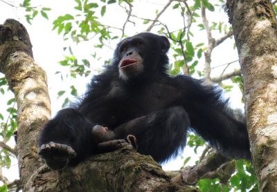
Seringbara chimpanzee © Kathelijne Koops

Site characteristics
Mount Nimba Strict Nature Reserve is located in the Nimba Mountains at the tri-national border of Guinea, Liberia and Côte d’Ivoire. It was designated a Strict Nature Reserve in 1944 (IUCN Category Ia) and is transboundary with Mount Nimba Integral Reserve (Côte d’Ivoire) and East Nimba Nature Reserve (Liberia, UNEP-WCMC and IUCN 2018). Unlike other protected areas in Guinea, Nimba was managed the Museum National d’Histoire Naturelle (Paris) and the Institut Français d’Afrique Noire (Dakar) after its creation (Brugière & Kormos 2009, Garnier & Martinez 2011). Consequently, the site as a long history of scientific studies (Garnier & Martinez 2011).
The reserve is now managed by the Centre for the Management of the Environment of Mount Nimba-Simandou (‘Centre National de Gestion de l’Environnement des Monts Nimba et Simandou‘, CEGENS) under the Ministry of Environment, Water and Forests and Sustainable Development, and fulfills administrative as well as scientific responsibilities (UNESCO 2018a).
The Nimba Mountains are a chain of mountains stretching across 40 km with the highest peak being Mount Nimba with 1,752m (Kormos & Boesch 2003). The area is characterized by a high plant and animal diversity and a high rate of endemism. The terrain is steep and the source if several rivers (Granier 2008). The habitat is moist forest up to 1,000 m altitude, but also includes grassland and wooded savanna (UNESCO 2018a). Due to strong seasonality and the abrupt change in altitude a variety of microclimates exist contributing to the high biodiversity (UNESCO 2018a). The most well-known endemic species are the Micropotamogale of Mount Nimba (Micropotamogale lamottei, a shrew), the viviparous toad of Mount Nimba (Nimbaphrynoides occidentalis) (UNESCO 2018a). In total, more than 317 vertebrate species, including 107 mammal species, more than 2,500 invertebrate species, and 2,000 plant species have been described (UNESCO 2018).
Mount Nimba Strict Nature Reserve has been a UNESCO World Heritage Site since 1981 and the only one in Guinea (UNESCO 2018). It covers both Guinea (125.4 km2) and Côte d’Ivoire (50 km2). However, due to the threat of iron mining and the arrival of a large number of refugees from Liberia it has been listed as World Heritage in Danger since 1992 (UNESCO 2018a).
Since 1980 the Guinean part of the Nimba Mountains is also part of the Mont Nimba Biosphere Reserve that also includes Déré forest and Bossou hills (UNESCO 2011).
Even though the avifauna is not well studied in the Guinean part of the Nimba Mountains, its diversity is assumed to be similar to the Liberian part of the mountain range, and the area is consequently recognized as an Important Bird Area (BirdLife International 2018a).
Unlike other protected areas in Guinea, Nimba was managed the Museum National d’Histoire Naturelle (Paris) and the Institut Français d’Afrique Noire (Dakar) after its creation (Brugière & Kormos 2009, Garnier & Martinez 2011). Consequently, the site as a long history of scientific studies (Garnier & Martinez 2011).
The reserve is now managed by the Centre for the Management of the Environment of Mount Nimba-Simandou (‘Centre National de Gestion de l’Environnement des Monts Nimba et Simandou‘, CEGENS) under the Ministry of Environment, Water and Forests and Sustainable Development, and fulfills administrative as well as scientific responsibilities (UNESCO 2018a).
The Nimba Mountains are a chain of mountains stretching across 40 km with the highest peak being Mount Nimba with 1,752m (Kormos & Boesch 2003). The area is characterized by a high plant and animal diversity and a high rate of endemism. The terrain is steep and the source if several rivers (Granier 2008). The habitat is moist forest up to 1,000 m altitude, but also includes grassland and wooded savanna (UNESCO 2018a). Due to strong seasonality and the abrupt change in altitude a variety of microclimates exist contributing to the high biodiversity (UNESCO 2018a). The most well-known endemic species are the Micropotamogale of Mount Nimba (Micropotamogale lamottei, a shrew), the viviparous toad of Mount Nimba (Nimbaphrynoides occidentalis) (UNESCO 2018a). In total, more than 317 vertebrate species, including 107 mammal species, more than 2,500 invertebrate species, and 2,000 plant species have been described (UNESCO 2018).
Mount Nimba Strict Nature Reserve has been a UNESCO World Heritage Site since 1981 and the only one in Guinea (UNESCO 2018). It covers both Guinea (125.4 km2) and Côte d’Ivoire (50 km2). However, due to the threat of iron mining and the arrival of a large number of refugees from Liberia it has been listed as World Heritage in Danger since 1992 (UNESCO 2018a).
Since 1980 the Guinean part of the Nimba Mountains is also part of the Mont Nimba Biosphere Reserve that also includes Déré forest and Bossou hills (UNESCO 2011).
Even though the avifauna is not well studied in the Guinean part of the Nimba Mountains, its diversity is assumed to be similar to the Liberian part of the mountain range, and the area is consequently recognized as an Important Bird Area (BirdLife International 2018a).
Table 1. Basic site information for Mount Nimba Strict Nature Reserve (Guinea)
| Species | Pan troglodytes verus |
| Area | 125 km² |
| Coordinates | Lat: 7.64 , Lon: -8.41 |
| Type of site | Protected area (Strict Nature Reserve) |
| Habitat types | Subtropical/tropical moist montane forest, Subtropical/tropical moist lowland forest, Savanna, Wetlands (lakes, rivers, streams, bogs, marshes), Agricultural land |
| Type of governance |
Types of sites Governance types Habitat types
Ape status
Surveys in different parts of the Nimba Mountains confirmed the presence of western chimpanzees (Sugiyama 1995, Shimada 2001). From the beginning these surveys were also aimed to study chimpanzee behavior, such as nesting behavior and tool-use behavior (details below). In the Regional Conservation Action Plan for western chimpanzees in 2003 the Nimba Mountains were identified as an ‘Exceptionally Important Priority Area’ (Kormos & Boesch 2003). Detailed surveys on chimpanzee density distribution were conducted by Nicolas Granier during multiple surveys after 2006 that focused on the eastern part of the protected area and the southern slope of Mount Nimba (Granier 2011, Granier et al. 2014). A transect survey conducted by the Wild Chimpanzee Foundation estimated the chimpanzee population in the reserve at around 166 individuals (WCF 2012). Since 1976, several surveys have been conducted in the Seringbara region by Sugiyama, who visited the area at least four times to interview the local population on chimpanzees, suggesting chimpanzees were present in the area. During his visits he also did two field surveys of the area (Shimada 2000). Shimada confirmed the presence of chimpanzees by recorded vocalizations and the presence of nests in 1999 (Shimada 2000). While it was at first thought that chimpanzees use this area only seasonally, more systematic surveys in 2000 and 2001 established the presence of at least one chimpanzee community (Humle & Matsuzawa 2001). Long-term chimpanzee research has been ongoing at the Seringbara study site since 2003 on the Guinean side of the Nimba Mountains (Koops 2011). The Seringbara study site is on the western side of the Nimba Mountains, in the foothills adjacent to the small village of Seringbara in south-eastern Guinea (7° 37’50.0”N, 8° 27’44.7”W). Since 2003, Kathelijne Koops has directed research at the Seringbara study site and researchers and field assistants have maintained a near-constant presence at the site. The study population remains only partly habituated to human observers due to the extremely rugged nature of the terrain. For more information on the study site, see Koops (2011), Koops et al (2007; 2010; 2012a, b; 2013; 2015, 2019) and Fitzgerald et al. (2018).
Table 2. Ape population estimates reported for Mount Nimba Strict Nature Reserve (Guinea)
| Species | Year | Occurrence | Encounter or vistation rate (nests/km; ind/day) | Density estimate [ind./ km²] (95% CI) | Abundance estimate (95% CI) | Survey area | Sampling method | Analytical framework | Source | Comments | A.P.E.S. database ID |
|---|---|---|---|---|---|---|---|---|---|---|---|
| Pan troglodytes verus | 2009-2011 | 0.46 | 8-39 | Southern slope of Nimba Mountains [covered Guinean section (10km2) and Côte d’Ivoirian section (50km²)] | Line transects & recces | Granier et al. 2014 | Total survey effort: 78.21 km; combination of line transect and reconnaissance survey, abundance and density estimate only based on transects (i.e., 12.5 km) | ||||
| Pan troglodytes verus | 2009 | 6.58 | 1.33 | 166.0 | Mount Nimba Strict Nature Reserve (i.e., Guinean part of Nimba Mountains) | Line transects | WCF 2012 | Total survey effort: 59.4 km | GIN0002, GIN0010, GIN0016, GIN0020, GIN0023, GIN0024, GIN0025, GIN0027, GIN0029, GIN0036, GIN0069 | ||
| Pan troglodytes verus | 2003-2004 | 1.72 | Seringbara (30 km²) | Line transects | Koops 2011 | ||||||
| Pan troglodytes verus | 2006-2008 | 1.14 | Eastern part of the reserve | Line transects & recces | Granier 2011 | Total survey effort: 350 km; combination of line transect, reconnaissance survey and scouting surveys | |||||
| Pan troglodytes verus | 2003-2014 | Present | Seringbara (30 km²) | Reconnaissance walk | Koops et al. (in prep.) | Genetic sampling (i.e., microsatellites), analyses are currently being finalized | |||||
| Pan troglodytes verus | 2000-2001 | Present | Seringbara (30 km²) | Unknown | Humle & Matsuzawa 2001 | ||||||
| Pan troglodytes verus | 1991 | Present | North of Goera | Reconnaissance walk | Sugiyama 1995 | Reconnaissance survey | |||||
| Pan troglodytes verus | 1999 | Present | North east of Seringbara village | Reconnaissance walk | Shimada 2000 | Reconnaissance survey | |||||
| Pan troglodytes verus | 1999 | Present | North of Goera | Reconnaissance walk | Shimada 2000 | Reconnaissance survey | |||||
| Pan troglodytes verus | 1999 | Present | Seringbara (30 km²) | Unknown | Shimada 2000 |
Sampling methods Analytical frameworks
Threats
Since 1992 Mount Nimba Strict Nature Reserve is listed as a ‘World Heritage in Danger’ because of plans to mine iron ore inside the reserve and an increase in anthropogenic pressure due to the arrival of refugees from Liberia (UNESCO 2018). Insufficient institutional structure was also reported as a threat (UNESCO 2018). As a result the boundary of the reserve were changed by the World Heritage Committee in 1993 and 15.5 km2 were degazetted so that mining operations could take place (Brugière & Kormos 2009).
Population density is high in the area around the reserve, also as consequence of mining activities in the Nimba Mountains. Consequently, poaching, wood extraction, land conversion to agriculture and cattle grazing using fires, and harvesting of medicinal plants is very prevalent across the area (Shimada 2000, WCF 2012, BirdLife International 2018b, UNESCO 2018a). In a nation-wide survey across 12 sites in Guinea, the Wild Chimpanzee Foundation concluded that Nimba was the most threatened site with 3.94 signs of human activity per km (WCF 2012). The most prevalent threat was poaching (2.74 signs/km), followed by agriculture, and wood extraction (WCF 2012). Agricultural activities have been on-going for decades especially in the northern part close to Seringbara and around Thuo towards the Liberian border (WCF 2012).
According to the World Heritage Centre, the Guinean government arranged for all mining operations to halt in the reserve and that mining permits had been withdrawn (UNESCO 2018b). However, mining will commence in the mining enclave, a part of the World Heritage Site that has been declassified. The World Heritage Center concluded that provided information was ambiguous, and that Environmental and Social Impact Assessments had not yet been implemented by mining companies or did not confirm to international standards (UNESCO 2018b). In addition, there are plans to tarmac a road from Lola (Guinea) to Danané (Côte d’Ivoire) that would pass by Mount Nimba and likely negatively impact biodiversity due to pollution, increased poaching and illegal logging (UNESCO 2018b).
Table 3. Threats to apes reported for Mount Nimba Strict Nature Reserve (Guinea)
| Category | Specific threats | Threat level | Description | Year of threat |
|---|---|---|---|---|
| 2 Agriculture & aquaculture | 2.1 Annual & perennial non-timber crops | Medium (30-70% of population affected) | Agricultural activities especially in the northern part around Seringbara and towards the border with Liberia (METT 2009, WCF 2012). | 2009-Ongoing (2012) |
| 2 Agriculture & aquaculture | 2.3 Livestock farming & ranching | Present (unknown severity) | Present (METT 2009, UNESCO 2018b), level of threat not known. | Ongoing (2018) |
| 3 Energy production & mining | 3.2 Mining & quarrying | Present (unknown severity) | Exploration for iron ore, activities seem to have ceased, but current threat level not clear (METT 2009, UNESCO 2018b). | 2009-Ongoing (2018) |
| 4 Transportation & service corridors | 4.1 Roads & railroads | Present (unknown severity) | Tarmacking of a road passing by the reserve in planning and would reinforce anthropogenic pressures such as poaching and illegal wood extraction (UNESCO 2018b), signs of paths inside reserve (WCF 2012). | 2012-Ongoing (2018) |
| 5 Biological resource use | 5.1 Hunting & collecting terrestrial animals | High (more than 70% of population affected) | Most prevalent sign of human activity inside the reserve (WCF 2012), also confirmed by BirdLife International 2018b, METT 2009, Shimada 2000, UNESCO 2018b. | 2000-Ongoing (2018) |
| 5 Biological resource use | 5.2 Gathering terrestrial plants | Medium (30-70% of population affected) | Collection of medicinal plants (BirdLife International 2018b) | Ongoing (2018) |
| 5 Biological resource use | 5.3 Logging & wood harvesting | Medium (30-70% of population affected) | Wood extraction (WCF 2012). | Ongoing (2012) |
| 7 Natural system modifications | 7.1 Fire & fire suppression | Medium (30-70% of population affected) | Fires used to clear land for agricultural and cattle grazing (METT 2009, UNESCO 2018b, WCF 2012). | 2009-Ongoing (2018) |
| 8 Invasive & other problematic species, genes & diseases | 8.4 Pathogens | Present (unknown severity) | Risk of disease transmission between humans and chimpanzees (reported for Seringbara; Koops & Fitzgerald pers. comm. 2019). | Ongoing (2019) |
Conservation activities
The governmental unit responsible for the administration of the reserve is the Centre for the Management of the Environment of Mount Nimba-Simandou (CEGENS) under the Ministry of Environment, Water and Forests and Sustainable Development, and fulfills administrative as well as scientific responsibilities (UNESCO 2018a). The project ‘Ministry of Environment, Water and Forests and Sustainable Development’ by Fauna & Flora International and funded by the Darwin Initiative established a transboundary biodiversity governance platform with the aim to compile data, build capacity and improve stakeholder collaboration (2009 -20012, Darwin Nimba Project). The project also received follow-up funding from USAID, but whether it is still operational as of 2018 is not clear. Activities included stakeholder consultation, capacity building through workshops and data compilation (Darwin Nimba Project). The nine-month project ‘Strengthening capacity of local communities to sustainably manage Mount Nimba’s natural resources’ headed by BirdLife International and financed by the Critical Ecosystem Partnership Fund’s (CEPF) was implemented by the ‘Initiative de Base pour la Gestion des Ressources Naturelles’ (IBGRN) until February 2018 (BirdLife International 2018b). The project established community groups, youth-led or women-led, and also two networks of traditional healers and hunters, and the groups also received legal status. Implemented activities included workshops and trainings in “micro-projects, internal governance, financial management, marketing, advocacy and communication” (BirdLife International 2018b). In addition, group members were trained in gardening and farming practices, and use of fuel efficient stoves with the aim to reduce reliance on natural resources from the protected area (BirdLife International 2018b). Conservation interventions at the Seringbara study site implemented by the Institut de Recherche Environnementale de Bossou (IREB) and Kyoto University Primate Research Institute (KUPRI) include environmental education, community projects, and snare removal www.greencorridor.info.
Table 4. Conservation activities reported for Mount Nimba Strict Nature Reserve (Guinea)
| Category | Specific activity | Description | Implementing organization(s) | Year of activity |
|---|---|---|---|---|
| 1 Development impact mitigation | 1.4 Farm more intensively and effectively in selected areas and spare more natural land | Communities received training on improved farming practices (BirdLife International 2018b). | 2017-2018 | |
| 2 Counter-wildlife crime | 2.13 Provide sustainable alternative livelihoods; establish fish- or domestic meat farms | Fish-farming projects in collaboration with local NGO (Koops & Fitzgerald pers. com.) | 2003-2004 | |
| 2 Counter-wildlife crime | 2.6 Regularly de-activate/remove ground snares | Researchers cut snares and report hunting evidence (Koops & Fitzgerald pers. com.) | 2003-Ongoing (2019) | |
| 3 Species health | 3.1 Wear face-masks to avoid transmission of viral and bacterial diseases to primates | Researchers wear face masks and clean shoes before entering forest (Koops & Fitzgerald pers. com.) | 2003-Ongoing (2019) | |
| 3 Species health | 3.2 Keep safety distance to habituated apes | Researchers keep minimum distance to chimpanzees (Koops & Fitzgerald pers. com.) | 2003-Ongoing (2019) | |
| 3 Species health | 3.4 Implement quarantine for people arriving at, and leaving the site | Quarantine for new researchers arriving at the study site (Koops & Fitzgerald pers. com.) | 2003-Ongoing (2019) | |
| 3 Species health | 3.6 Ensure that researchers/tourists are up-to-date with vaccinations and healthy | Researchers required to be vaccinated (Koops & Fitzgerald pers. com.) | 2003-Ongoing (2019) | |
| 4 Education & awareness | 4.1 Educate local communities about apes and sustainable use | IREB and KUPRI periodically conduct environmental education activities in local schools, sessions in villages close to study site by researchers at Seringbara (Koops & Fitzgerald pers. com.) | 2003-Ongoing (2019) | |
| 4 Education & awareness | 4.5 Implement multimedia campaigns using theatre, film, print media, discussions | Education sessions include group discussions, presentations, showing videos (Koops & Fitzgerald pers. com.) | 2003-Ongoing (2019) | |
| 5 Protection & restoration | 5.2 Legally protect ape habitat | Designated a Strict Nature Reserve in 1944 (UNEP-WCMC and IUCN 2018) | 1944-Ongoing (2026) | |
| 7 Economic & other incentives | 7.2 Provide non-monetary benefits to local communities for sustainably managing their forest and its wildlife (e.g., better education, infrastructure development) | Local capacity building (e.g. schools, water pumps, etc.) by researchers at Seringbara (KUPRI) and local counter parts (IREB) (Koops & Fitzgerald pers. com.) | 2003-Ongoing (2019) |
Challenges
Lack of transboundary cooperation as well as lack of technical, financial and human resources were mentioned as impediments to effective protection of the reserve (Granier and Martinez 2011, UNESCO 2018a, UNESCO 2018b).
Table 5. Challenges reported for Mount Nimba Strict Nature Reserve (Guinea)
| Challenges | Specific challenges | Source | Year(s) |
|---|---|---|---|
| 2 Resources and capacity | 2.1 Lack of capacity/training | UNESCO 2018a, UNESCO 2018b | |
| 2 Resources and capacity | 2.2 Lack of staff | UNESCO 2018b | |
| 2 Resources and capacity | 2.3 General lack of funding | UNESCO 2018a, UNESCO 2018b | |
| 2 Resources and capacity | 2.5 Lack of equipment/transportation | UNESCO 2018a | |
| 4 Institutional support | 4.4 Lack of transboundary cooperation | Granier and Martinez 2011, UNESCO 2018b |
Enablers
Table 6. Enablers reported for Mount Nimba Strict Nature Reserve (Guinea)
| Enablers | Specific enablers | Source | Year(s) |
|---|---|---|---|
| 1 Site management | |||
| 2 Resources and capacity | |||
| 3 Engaged community | |||
| 4 Institutional support | |||
| 5 Ecological context | |||
| 6 Safety and stability |
Research activities
The Nimba Mountains have been the focus of research for several decades. In the 1940’s a research station was established in Ziéla, to the North of the Nimba Mountains, and researchers including Maxime Lamotte, Roger Roy, and other scientists from the Institut Français d’Afrique Noire in Dakar, conducted studies on the fauna and flora, but also on climate and geology (Granier & Martinez 2011). In the context of the recognition of Nimba as a World Heritage Site several missions have been conducted by UNESCO (UNESCO 2018b). Many other organizations conducted research here, for example on the Nimba toad (Hillers et al. 2008, Sandberger-Loua et al. 2016). Studies targeted at chimpanzees in the Mount Nimba Strict Nature reserve, also investigated chimpanzee behavior, such as tool use (Sugiyama 1995, Shimada 2000), but also habitat use and nesting behavior (Granier et al. 2014). Established in 2003, Seringbara research area is located within the Mont Nimba Strict Nature Reserve on the western side of the Nimba Massif in southeastern Guinea. The area is adjacent to the village of Seringbara, approximately 6 km from Bossou, Guinea and 10 km from Yealé, Cote d’Ivoire (Koops 2011). It is separated from the Bossou hills by a 4 km stretch of savanna, an area that has been the focus of reforestation efforts by the Green Corridor Project. Long-term chimpanzee research is ongoing at the Seringbara study site in Guinea. Initial research at Seringbara focused on tool use behaviour by the Nimba chimpanzees especially in comparison to the chimpanzees at Bossou (e.g., Humle & Matsuzawa 2001, Koops 2011, Shimada 2000, Sugiyama 1995). Subsequently, Seringbara research broadened to include chimpanzee tool use patterns (Koops et al. 2013, 2015), feeding ecology (Koops 2011, Koops et al. 2013, 2019), grouping and ranging patterns (van Leeuwen et al. in press), nesting behaviour (Koops et al. 2007, 2012a,b), habitat suitability modeling (Fitzgerald et al. 2018), molecular genetics (Koops et al 2012b, Koops et al. in prep), nutritional analyses (Koops et al. 2019) and conservation strategies (Fitzgerald et al. in prep).
Documented behaviours
Table 7. Behaviours documented for Mount Nimba Strict Nature Reserve (Guinea)
| Category | Behavior | Observation type | Prevalence | Observation dates | Source | Habituation | Species | Comment |
|---|---|---|---|---|---|---|---|---|
| Ant dipping | Humle & Matsuzawa 2001, Koops et al. 2015, Granier 2011 | |||||||
| Crab fishing | Koops et al. 2019 | |||||||
| Fruit cleaving (Treculia) | Koops et al. 2010 | |||||||
| Hand clapping | Koops & Matsuzawa 2006 | |||||||
| Leaf biting | Koops 2011 | |||||||
| Leaf cushion | Koops 2011 | |||||||
| Leaf swallowing | Koops 2011 | |||||||
| Making ground nests | Humle & Matsuzawa 2001, Koops et al. 2007, Koops 2011, Koops et al. 2012a,b | |||||||
| Medicinal uses of leaves | Koops 2011 |
Exposure to climate change impacts
As part of a study on the exposure of African great ape sites to climate change impacts, Kiribou et al. (2024) extracted climate data and data on projected extreme climate impact events for the site. Climatological characteristics were derived from observation-based climate data provided by the Inter-Sectoral Impact Model Intercomparison Project (ISIMIP, www.isimip.org). Parameters were calculated as the average across each 30-year period. For 1981-2010, the EWEMBI dataset from ISIMIP2a was used. For the two future periods (2021-2050 and 2071-2099) ISIMIP2b climate data based on four CMIP5 global climate models were used. For future projections, two Representative Concentration Pathways (RCP) were used. RCP 2.6 is a scenario with strong mitigation measures in which global temperatures would likely rise below 2C. RCP 6.0 is a scenario with medium emissions in which global temperatures would likely rise up to 3C by 2100. For the number of days with heavy precipitation events, the 98th percentile of all precipitation days (>1mm/d) was calculated for the 1979-2013 reference period as a threshold for a heavy precipitation event. Then, for each year, the number of days above that threshold was derived. The figures on temperature and precipitation anomaly show the deviation from the mean temperature and mean precipitation for the 1979-2013 reference period.
The estimated exposure to future extreme climate impact events (crop failure, drought, river flood, wildfire, tropical cyclone, and heatwave) is based on a published dataset by Lange et al. 2020 derived from ISIMIP2b data. The same global climate models and RCPs as described above were used. Within each 30-year period, the number of years with an extreme event and the average proportion of the site affected were calculated (Kiribou et al. 2024).
Table 8. Estimated past and projected climatological characteristics in Mount Nimba Strict Nature Reserve (Guinea)
| Value | 1981-2010 | 2021-2050, RCP 2.6 | 2021-2050, RCP 6.0 | 2071-2099, RCP 2.6 | 2071-2099, RCP 6.0 |
|---|---|---|---|---|---|
| Mean temperature [C] | 24.6 | 25.7 | 25.7 | 25.8 | 27 |
| Annual precipitation [mm] | 1801 | 1844 | 1876 | 1869 | 1941 |
| Max no. consecutive dry days (per year) | 34.2 | 32.9 | 32.3 | 33.7 | 35.2 |
| No. days with heavy precipitation (per year) | 5.7 | 8 | 8 | 8.7 | 9.9 |
Table 9. Projected exposure of apes to extreme climate impact events in Mount Nimba Strict Nature Reserve (Guinea)
| Type | No. of years with event (2021-2050, RCP 2.6) | % of site exposed (2021-2050, RCP 2.6) | No. of years with event (2021-2050, RCP 6.0) | % of site exposed (2021-2050, RCP 6.0) | No. of years with event (2070-2099, RCP 2.6) | % of site exposed (2070-2099, RCP 2.6) | No. of years with event (2070-2099, RCP 6.0) | % of site exposed (2070-2099, RCP 6.0) |
|---|---|---|---|---|---|---|---|---|
| Crop failure | 3 | 4.49 | 2 | 4.49 | 2 | 4.49 | 7 | 4.49 |
| Drought | 0 | 0 | 0 | 0 | 0 | 0 | 0 | 0 |
| Heatwave | 6.5 | 100 | 3.5 | 100 | 5.5 | 100 | 6 | 100 |
| River flood | 0.5 | 0.61 | 1.25 | 0.81 | 2 | 1.22 | 3.5 | 0.93 |
| Tropical cyclone | 0 | 0 | 0 | 0 | 0 | 0 | 0 | 0 |
| Wildfire | 30 | 0.52 | 30 | 0.5 | 29 | 0.5 | 29 | 0.53 |
-
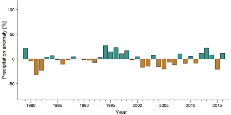
Precipitation anomaly in Mount Nimba Strict Nature Reserve (Guinea) -
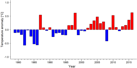
Temperature anomaly in Mount Nimba Strict Nature Reserve (Guinea)


External links
References
BirdLife International. (2018a). Important Bird Areas factsheet: Monts Nimba (part of Mount Nimba transboundary AZE). Retrieved from http://datazone.birdlife.org/site/factsheet/monts-nimba-(part-of-mount-nimba-transboundary-aze)-iba-guinea
BirdLife International. (2018b). Fighting rural poverty: Community empowered to conserve Guinean mountain reserve. https://www.birdlife.org/worldwide/news/fighting-rural-poverty-community-empowered-conserve-guinean-mountain-reserve
Brugiere, D., & Kormos, R. (2009). Review of the protected area network in Guinea, West Africa, and recommendations for new sites for biodiversity conservation. Biodiversity and Conservation, 18, 847. doi:10.1007/s10531-008-9508-z
Fitzgerald, M., Coulson, R., Lawing, A. M., Matsuzawa, T., & Koops, K. (2018). Modeling habitat suitability for chimpanzees (Pan troglodytes verus) in the Greater Nimba Landscape, Guinea, West Africa. Primates, 59(4), 361-375. doi:10.1007/s10329-018-0657-8
Granier, N. (2008). Ecological study and conservation of chimpanzees Pan troglodytes verus in the Nimba Mountain Biosphere Reserve, Republic of Guinea. Report to the Section on Great Apes of the IUCN/SSC Primate Specialist Group and Conservation International.
Granier, N. (2011). Chimpanzees in the Eastern Part of the Nimba Mountains Biosphere Reserve: Gouéla II and Déré Forest. In Primatology Monographs (pp. 289-299). Springer Japan. doi:10.1007/978-4-431-53921-6_30
Granier, N., Hambuckers, A., Matsuzawa, T., & Huynen, M. (2014). Density estimates and nesting‐site selection in chimpanzees of the Nimba Mountains, Côte d'Ivoire, and Guinea. American Journal of Primatology, 76(11), 999-1010. doi:10.1002/ajp.22278
Granier, N., & Martinez, L. (2011). Conservation Issues in the Nimba Mountains. In Primatology Monographs (pp. 381-392). Springer Japan. doi:10.1007/978-4-431-53921-6_40
Hillers, A., Loua, N., & Rödel, M. (2008). Assessment of the distribution and conservation status of the viviparous toad Nimbaphrynoides occidentalis on Monts Nimba, Guinea†. Endangered Species Research, 5, 13-19. doi:10.3354/esr00099
Koops, K., et al. (2007). Ground-nesting by the chimpanzees of the Nimba Mountains, Guinea: Environmentally or socially determined? American Journal of Primatology, 69, 407–419. doi:10.1002/ajp.20358
Koops, K., et al. (2010). Do chimpanzees (Pan troglodytes) use cleavers and anvils to fracture Treculia africana fruits? Preliminary data on a new form of percussive technology. Primates, 51, 175–178. doi:10.1007/s10329-009-0178-6
Koops, K., et al. (2012a). Nest-building by chimpanzees (Pan troglodytes verus) at Seringbara, Nimba Mountains: Anti-predation, thermoregulation, and anti-vector hypotheses. International Journal of Primatology, 33(2), 356–380. doi:10.1007/s10764-012-9585-4
Koops, K., et al. (2012b). Terrestrial nest-building in wild chimpanzees (Pan troglodytes verus): Implications for the tree-to-ground sleep transition in early hominins. American Journal of Physical Anthropology, 148, 351–361.
Koops, K., McGrew, W. C., & Matsuzawa, T. (2013). Ecology of culture: do environmental factors influence foraging tool use in wild chimpanzees, Pan troglodytes verus?. Animal Behaviour, 85(1), 175-185. doi:10.1016/j.anbehav.2012.10.022
Koops, K., et al. (2015). Chimpanzees prey on army ants at Seringbara, Nimba Mountains, Guinea: Predation patterns and tool characteristics. American Journal of Primatology, 77, 319–329. doi:10.1002/ajp.22347
Koops, K., Wrangham, R. W., Cumberlidge, N., Fitzgerald, M. A., van Leeuwen, K. L., Rothman, J. M., & Matsuzawa, T. (2019). Crab-fishing by chimpanzees in the Nimba Mountains, Guinea. Journal of Human Evolution, 133, 230-241. doi:10.1016/j.jhevol.2019.05.002
Koops, K. (2011). Chimpanzees in the Seringbara Region of the Nimba Mountains. In Matsuzawa, T., Humle, T., & Sugiyama, Y. (Eds.), The Chimpanzees of Bossou and Nimba (pp. 277-287). Springer Japan. doi:10.1007/978-4-431-53921-6_29
Kormos, R., & Boesch, C. (2003). Regional action plan for the conservation of chimpanzees in West Africa. IUCN/SSC Primate Specialist Group and Conservation International. link
METT. (2009). Management effectiveness evaluations: Réserve naturelle intégrale des Monts Nimba. https://papaco.org/guinea/ link
Sandberger-Loua, L., Doumbia, J., & Rödel, M. (2016). Conserving the unique to save the diverse — Identifying key environmental determinants for the persistence of the viviparous Nimba toad in a West African World Heritage Site. Biological Conservation, 198, 15-21. doi:10.1016/j.biocon.2016.03.033
Shimada, M. K. (2000). A Survey of the Nimba Mountains, West Africa from Three Routes: Confirmed New Habitat and Ant-Catching Wand Use of Chimpanzees. Pan Africa News, 7(1), 7-10. doi:10.5134/143384
Sugiyama, Y. (1995). Tool-use for catching ants by chimpanzees at Bossou and Monts Nimba, West Africa. Primates, 36(2), 193-205. doi:10.1007/bf02381345
UNEP-WCMC & IUCN. (2018). Protected Planet: The World Database on Protected Areas (WDPA). UNEP-WCMC and IUCN. https://www.protectedplanet.net/mount-nimba-strict-nature-reserve link
UNESCO. (2018a). Mount Nimba Strict Nature Reserve. https://whc.unesco.org/en/list/155
UNESCO. (2018b). State of conservation: Mount Nimba Strict Nature Reserve. https://whc.unesco.org/en/soc/3810
UNESCO MAB. (2011). UNESCO MAB Biosphere Reserve Directory: Haut Niger. http://www.unesco.org/new/en/natural-sciences/environment/ecological-sciences/biosphere-reserves/africa/guinea/mont-nimba/ link
WCF. (2012). État de la faune et des menaces dans les aires protégées terrestres et principales zones de forte biodiversité de Rep. de Guinée. Wild Chimpanzee Foundation. http://www.wildchimps.org
USAID (2018). PA FACT SHEET SONG THANH NATURE RESERVE. Online: https://pdf.usaid.gov/pdf_docs/PA00TSDW.pdf link
Matsuzawa, T., et al. (2011a). Green corridor project: Planting trees in the savanna between Bossou and Nimba. In T. Matsuzawa, T. Humle, & Y. Sugiyama (Eds.), The chimpanzees of Bossou and Nimba. Springer. doi:10.1007/978-4-431-53921-6_38
Kiribou, R., Tehoda, P., Chukwu, O., Bempah, G., Kühl, H. S., Ferreira, J., …, & Heinicke, S. (2024). Exposure of African ape sites to climate change impacts. PLOS Climate, 3(2), e0000345. doi:10.1371/journal.pclm.0000345
Page created by: Kathelijne Koops & Maegan Fitzgerald Date: 2019-11-27
Page updated by: APES Atlas Team Date: 2025-06-20