
Mbe Mountains: Difference between revisions
No edit summary |
No edit summary |
||
| Line 74: | Line 74: | ||
|Reconnaissance walk | |Reconnaissance walk | ||
| | | | ||
|Imong, Wood & Dunn 2010 | |[[#R01200|Imong, Wood & Dunn 2010]] | ||
| | | | ||
| | | | ||
| Line 87: | Line 87: | ||
|Reconnaissance walk | |Reconnaissance walk | ||
| | | | ||
|Imong, Wood & Dunn 2010 | |[[#R01200|Imong, Wood & Dunn 2010]] | ||
| | | | ||
| | | | ||
| Line 109: | Line 109: | ||
|2.1.2 Small-holder farming | |2.1.2 Small-holder farming | ||
|High (more than 70% of population affected) | |High (more than 70% of population affected) | ||
|Farming and logging in surrounding lowlands threatens to isolate Mbe from adjacent forests and to destroy the two corridors linking Mbe to Afi and Okwangwo ([https://nigeria.wcs.org/Wild-Places/Mbe-Mountains.aspx WCS Nigeria]). Farming encroachment reported during a 2009 survey (Imong, Wood & Dunn 2010). | |Farming and logging in surrounding lowlands threatens to isolate Mbe from adjacent forests and to destroy the two corridors linking Mbe to Afi and Okwangwo ([https://nigeria.wcs.org/Wild-Places/Mbe-Mountains.aspx WCS Nigeria]). Farming encroachment reported during a 2009 survey ([[#R01200|Imong, Wood & Dunn 2010]]). | ||
|Ongoing (2009) | |Ongoing (2009) | ||
|- | |- | ||
| Line 115: | Line 115: | ||
|5.1 Hunting & collecting terrestrial animals | |5.1 Hunting & collecting terrestrial animals | ||
|High (more than 70% of population affected) | |High (more than 70% of population affected) | ||
|Several wire snares were removed during a survey conducted in 2009 (Imong, Wood & Dunn 2010). Hunting activity in the Mbe Mountains is relatively low compared to the other sites, but it is still a major threat ([https://nigeria.wcs.org/Wild-Places/Mbe-Mountains.aspx WCS Nigeria]). | |Several wire snares were removed during a survey conducted in 2009 ([[#R01200|Imong, Wood & Dunn 2010]]). Hunting activity in the Mbe Mountains is relatively low compared to the other sites, but it is still a major threat ([https://nigeria.wcs.org/Wild-Places/Mbe-Mountains.aspx WCS Nigeria]). | ||
|2009-Ongoing (2014) | |2009-Ongoing (2014) | ||
|- | |- | ||
| Line 197: | Line 197: | ||
|2 Resources and capacity | |2 Resources and capacity | ||
|2.4 Lack of continuous/long-term funding | |2.4 Lack of continuous/long-term funding | ||
|Shomkegh et al. 2017 | |[[#R01202|Shomkegh et al. 2017]] | ||
|2017 | |2017 | ||
|} | |} | ||
| Line 216: | Line 216: | ||
|2 Resources and capacity | |2 Resources and capacity | ||
|2.3 Continuous/long-term funding | |2.3 Continuous/long-term funding | ||
|Shomkegh et al. 2017 | |[[#R01202|Shomkegh et al. 2017]] | ||
|2017 | |2017 | ||
|} | |} | ||
| Line 258: | Line 258: | ||
= Exposure to climate change impacts = | = Exposure to climate change impacts = | ||
As part of a study on the exposure of African great ape sites to climate change impacts, Kiribou et al. (2024) extracted climate data and data on projected extreme climate impact events for the site. Climatological characteristics were derived from observation-based climate data provided by the Inter-Sectoral Impact Model Intercomparison Project (ISIMIP, www.isimip.org). Parameters were calculated as the average across each 30-year period. For 1981-2010, the EWEMBI dataset from ISIMIP2a was used. For the two future periods (2021-2050 and 2071-2099) ISIMIP2b climate data based on four CMIP5 global climate models were used. For future projections, two Representative Concentration Pathways (RCP) were used. RCP 2.6 is a scenario with strong mitigation measures in which global temperatures would likely rise below 2C. RCP 6.0 is a scenario with medium emissions in which global temperatures would likely rise up to 3C by 2100. For the number of days with heavy precipitation events, the 98th percentile of all precipitation days (>1mm/d) was calculated for the 1979-2013 reference period as a threshold for a heavy precipitation event. Then, for each year, the number of days above that threshold was derived. The figures on temperature and precipitation anomaly show the deviation from the mean temperature and mean precipitation for the 1979-2013 reference period. | As part of a study on the exposure of African great ape sites to climate change impacts, [[#R02261|Kiribou et al. (2024)]] extracted climate data and data on projected extreme climate impact events for the site. Climatological characteristics were derived from observation-based climate data provided by the Inter-Sectoral Impact Model Intercomparison Project (ISIMIP, www.isimip.org). Parameters were calculated as the average across each 30-year period. For 1981-2010, the EWEMBI dataset from ISIMIP2a was used. For the two future periods (2021-2050 and 2071-2099) ISIMIP2b climate data based on four CMIP5 global climate models were used. For future projections, two Representative Concentration Pathways (RCP) were used. RCP 2.6 is a scenario with strong mitigation measures in which global temperatures would likely rise below 2C. RCP 6.0 is a scenario with medium emissions in which global temperatures would likely rise up to 3C by 2100. For the number of days with heavy precipitation events, the 98th percentile of all precipitation days (>1mm/d) was calculated for the 1979-2013 reference period as a threshold for a heavy precipitation event. Then, for each year, the number of days above that threshold was derived. The figures on temperature and precipitation anomaly show the deviation from the mean temperature and mean precipitation for the 1979-2013 reference period. | ||
The estimated exposure to future extreme climate impact events (crop failure, drought, river flood, wildfire, tropical cyclone, and heatwave) is based on a published dataset by Lange et al. 2020 derived from ISIMIP2b data. The same global climate models and RCPs as described above were used. Within each 30-year period, the number of years with an extreme event and the average proportion of the site affected were calculated (Kiribou et al. 2024). | The estimated exposure to future extreme climate impact events (crop failure, drought, river flood, wildfire, tropical cyclone, and heatwave) is based on a published dataset by Lange et al. 2020 derived from ISIMIP2b data. The same global climate models and RCPs as described above were used. Within each 30-year period, the number of years with an extreme event and the average proportion of the site affected were calculated ([[#R02261|Kiribou et al. 2024]]). | ||
'''Table 8. Estimated past and projected climatological characteristics in Mbe Mountains''' | '''Table 8. Estimated past and projected climatological characteristics in Mbe Mountains''' | ||
| Line 383: | Line 383: | ||
= References = | = References = | ||
Imong, I., Wood, K. L., & Dunn, A. (2010). Monitoring gorillas in Nigeria. Berggorilla & Regenwald Direkthilfe. https://www.berggorilla.org/en/home/news-archive/article-view/monitoring-gorillas-in-nigeria/ | <span id="R01200"></span>Imong, I., Wood, K. L., & Dunn, A. (2010). Monitoring gorillas in Nigeria. Berggorilla & Regenwald Direkthilfe. https://www.berggorilla.org/en/home/news-archive/article-view/monitoring-gorillas-in-nigeria/ | ||
Imong, I., Eban, J., & Mengjo, C. (2014). Using technology to save gorillas in the Mbe Mountains. Gorilla Journal, 48, 16–17. | <span id="R01201"></span>Imong, I., Eban, J., & Mengjo, C. (2014). Using technology to save gorillas in the Mbe Mountains. Gorilla Journal, 48, 16–17. | ||
Shomkegh, S. A., Adaje, P. O., & Dagba, B. I. (2017). Assessment of community participation in forest resources management in Afi and Mbe Mountains, Cross River State, Nigeria. Journal of Environmental Science, Toxicology and Food Technology (IOSR-JESTFT), 11(12), 41–47. | <span id="R01202"></span>Shomkegh, S. A., Adaje, P. O., & Dagba, B. I. (2017). Assessment of community participation in forest resources management in Afi and Mbe Mountains, Cross River State, Nigeria. Journal of Environmental Science, Toxicology and Food Technology (IOSR-JESTFT), 11(12), 41–47. | ||
WCS Nigeria. (n.d.). Mbe Mountains. Retrieved February 5, 2025, from https://nigeria.wcs.org/Wild-Places/Mbe-Mountains.aspx < | <span id="R01203"></span>WCS Nigeria. (n.d.). Mbe Mountains. Retrieved February 5, 2025, from https://nigeria.wcs.org/Wild-Places/Mbe-Mountains.aspx | ||
<span id="R02261"></span>Kiribou, R., Tehoda, P., Chukwu, O., Bempah, G., Kühl, H. S., Ferreira, J., …, & Heinicke, S. (2024). Exposure of African ape sites to climate change impacts. ''PLOS Climate'', 3(2), e0000345. [https://doi.org/10.1371/journal.pclm.0000345 doi:10.1371/journal.pclm.0000345] | |||
'''Page created by: '''Priscilla Stanley Shao''' Date:''' 2024-11-25 10:42:00 | '''Page created by: '''Priscilla Stanley Shao''' Date:''' 2024-11-25 10:42:00 | ||
Revision as of 16:29, 12 October 2026
West Africa > Nigeria > Mbe Mountains
Français | Português | Español | Bahasa Indonesia | Melayu
Summary
- Nigeria-Cameroon chimpanzees (Pan troglodytes ellioti) & Cross river gorillas (Gorilla gorilla diehli) are present in Mbe Mountains.
- The population sizes are unknown.
- The population trends are unknown.
Site characteristics
The Mbe Mountains span approximately 85 km², serving as a vital habitat corridor that connects the Afi Mountain Wildlife Sanctuary with the Okwangwo Division of Cross River National Park (WCS Nigeria). Although they lack formal conservation status, the Mbe Mountains are traditionally owned by nine surrounding communities and have been managed by the Conservation Association of the Mbe Mountains, with support from WCS, since 2007. Reaching elevations of up to 900 meters, the Mbe Mountains provide a crucial refuge for the critically endangered Cross River gorilla (Gorilla gorilla diehli), along with other distinctive species such as the Nigeria-Cameroon chimpanzee (Pan troglodytes ellioti), the drill (Mandrillus leucophaeus), and the grey-necked rockfowl (Picathartes oreas) (WCS Nigeria).
Table 1. Basic site information for Mbe Mountains
| Species | Pan troglodytes ellioti, Gorilla gorilla diehli |
| Area | 85 km² |
| Coordinates | Lat: 6.220958 , Lon: 9.068399
|
| Type of site | Non-protected area (Community Forest) |
| Habitat types | Subtropical/tropical moist montane forest |
| Type of governance | Governance by indigenous peoples and local communities |
Types of sites Governance types Habitat types
Ape status
Table 2. Ape population estimates reported for Mbe Mountains
| Species | Year | Occurrence | Encounter or vistation rate (nests/km; ind/day) | Density estimate [ind./ km²] (95% CI) | Abundance estimate (95% CI) | Survey area | Sampling method | Analytical framework | Source | Comments | A.P.E.S. database ID |
|---|---|---|---|---|---|---|---|---|---|---|---|
| Gorilla gorilla diehli | 2009 | 20 | Mbe Mountains | Reconnaissance walk | Imong, Wood & Dunn 2010 | ||||||
| Pan troglodytes ellioti | 2009 | Present | Mbe Mountains | Reconnaissance walk | Imong, Wood & Dunn 2010 |
Sampling methods Analytical frameworks
Threats
Table 3. Threats to apes reported for Mbe Mountains
| Category | Specific threats | Threat level | Description | Year of threat |
|---|---|---|---|---|
| 2 Agriculture & aquaculture | 2.1.2 Small-holder farming | High (more than 70% of population affected) | Farming and logging in surrounding lowlands threatens to isolate Mbe from adjacent forests and to destroy the two corridors linking Mbe to Afi and Okwangwo (WCS Nigeria). Farming encroachment reported during a 2009 survey (Imong, Wood & Dunn 2010). | Ongoing (2009) |
| 5 Biological resource use | 5.1 Hunting & collecting terrestrial animals | High (more than 70% of population affected) | Several wire snares were removed during a survey conducted in 2009 (Imong, Wood & Dunn 2010). Hunting activity in the Mbe Mountains is relatively low compared to the other sites, but it is still a major threat (WCS Nigeria). | 2009-Ongoing (2014) |
| 5 Biological resource use | 5.3 Logging & wood harvesting | High (more than 70% of population affected) | Illegal logging, particularly for ebony, is a growing problem particularly within the lowland areas surrounding the Mbe Mountains (WCS Nigeria). | Unknown |
Conservation activities
Table 4. Conservation activities reported for Mbe Mountains
| Category | Specific activity | Description | Implementing organization(s) | Year of activity |
|---|---|---|---|---|
| 2 Counter-wildlife crime | 2.11 Implement monitoring surveillance strategies (e.g., SMART) or use monitoring data to improve effectiveness of patrols | Use of CyberTracker and SMART (Imong, Eban & Mengjo 2014; WCS Nigeria). | WCS Nigeria | 2009-Ongoing (2014) |
| 2 Counter-wildlife crime | 2.3 Conduct regular anti-poaching patrols | With local support, and constant efforts by a team of 14 eco-guards managed by WCS, levels of hunting have been reduced compared to surrounding areas (WCS Nigeria). | WCS Nigeria | Unknown |
| 4 Education & awareness | 4.1 Educate local communities about apes and sustainable use | The formation of 11 school conservation clubs, which have regular field trips and exchange visits (WCS Nigeria). | WCS Nigeria | Unknown |
| 4 Education & awareness | 4.2 Involve local community in ape research and conservation management | Establishment of the Conservation Association of the Mbe Mountains (CAMM) to protect the forest and its wildlife and boost local development (WCS Nigeria). | WCS Nigeria | Unknown |
| 4 Education & awareness | 4.4 Regularly play TV and radio announcements to raise ape conservation awareness | Outreach programs that use radio drama and film shows to spread conservation messages within the area (WCS Nigeria). | WCS Nigeria | Unknown |
| 7 Economic & other incentives | 7.2 Provide non-monetary benefits to local communities for sustainably managing their forest and its wildlife (e.g., better education, infrastructure development) | WCS has trained more than 100 farmers from the nine Mbe communities in various activities as an alternative source of income and to reduce levels of dependence on the forest particularly hunting (WCS Nigeria). | WCS Nigeria | Unknown |
| 8 Permanent presence | 8.1 Run research project and ensure permanent human presence at site | Research is being conducted at Mbe Mountains to assess the population of the Cross River Gorillas (WCS Nigeria). | WCS Nigeria | Ongoing (2016) |
Challenges
Table 5. Challenges reported for Mbe Mountains
| Challenges | Specific challenges | Source | Year(s) |
|---|---|---|---|
| 2 Resources and capacity | 2.4 Lack of continuous/long-term funding | Shomkegh et al. 2017 | 2017 |
Enablers
Table 6. Enablers reported for Mbe Mountains
| Enablers | Specific enablers | Source | Year(s) |
|---|---|---|---|
| 2 Resources and capacity | 2.3 Continuous/long-term funding | Shomkegh et al. 2017 | 2017 |
Research activities
Documented behaviours
Table 7. Behaviours documented for Mbe Mountains
| Category | Behavior | Observation type | Prevalence | Observation dates | Source | Habituation | Species | Comment |
|---|---|---|---|---|---|---|---|---|
| Not reported |
Exposure to climate change impacts
As part of a study on the exposure of African great ape sites to climate change impacts, Kiribou et al. (2024) extracted climate data and data on projected extreme climate impact events for the site. Climatological characteristics were derived from observation-based climate data provided by the Inter-Sectoral Impact Model Intercomparison Project (ISIMIP, www.isimip.org). Parameters were calculated as the average across each 30-year period. For 1981-2010, the EWEMBI dataset from ISIMIP2a was used. For the two future periods (2021-2050 and 2071-2099) ISIMIP2b climate data based on four CMIP5 global climate models were used. For future projections, two Representative Concentration Pathways (RCP) were used. RCP 2.6 is a scenario with strong mitigation measures in which global temperatures would likely rise below 2C. RCP 6.0 is a scenario with medium emissions in which global temperatures would likely rise up to 3C by 2100. For the number of days with heavy precipitation events, the 98th percentile of all precipitation days (>1mm/d) was calculated for the 1979-2013 reference period as a threshold for a heavy precipitation event. Then, for each year, the number of days above that threshold was derived. The figures on temperature and precipitation anomaly show the deviation from the mean temperature and mean precipitation for the 1979-2013 reference period.
The estimated exposure to future extreme climate impact events (crop failure, drought, river flood, wildfire, tropical cyclone, and heatwave) is based on a published dataset by Lange et al. 2020 derived from ISIMIP2b data. The same global climate models and RCPs as described above were used. Within each 30-year period, the number of years with an extreme event and the average proportion of the site affected were calculated (Kiribou et al. 2024).
Table 8. Estimated past and projected climatological characteristics in Mbe Mountains
| Value | 1981-2010 | 2021-2050, RCP 2.6 | 2021-2050, RCP 6.0 | 2071-2099, RCP 2.6 | 2071-2099, RCP 6.0 |
|---|---|---|---|---|---|
| Mean temperature [C] | 25.3 | 26.4 | 26.2 | 26.5 | 27.6 |
| Annual precipitation [mm] | 2359 | 2468 | 2490 | 2470 | 2441 |
| Max no. consecutive dry days (per year) | 40.6 | 40 | 42 | 40.6 | 45.4 |
| No. days with heavy precipitation (per year) | 4.8 | 4.7 | 4.9 | 4.8 | 5.9 |
Table 9. Projected exposure of apes to extreme climate impact events in Mbe Mountains
| Type | No. of years with event (2021-2050, RCP 2.6) | % of site exposed (2021-2050, RCP 2.6) | No. of years with event (2021-2050, RCP 6.0) | % of site exposed (2021-2050, RCP 6.0) | No. of years with event (2070-2099, RCP 2.6) | % of site exposed (2070-2099, RCP 2.6) | No. of years with event (2070-2099, RCP 6.0) | % of site exposed (2070-2099, RCP 6.0) |
|---|---|---|---|---|---|---|---|---|
| Crop failure | 5.5 | 0.18 | 6 | 0.31 | 3.5 | 0.23 | 7.5 | 0.23 |
| Drought | 0 | 0 | 0 | 0 | 0 | 0 | 0 | 0 |
| Heatwave | 3 | 100 | 5 | 100 | 3 | 100 | 5 | 100 |
| River flood | 1.5 | 0.17 | 1 | 1.87 | 1.5 | 1.15 | 2.5 | 1.23 |
| Tropical cyclone | 0 | 0 | 0 | 0 | 0 | 0 | 0 | 0 |
| Wildfire | 30 | 0.74 | 30 | 0.74 | 29 | 0.74 | 29 | 0.74 |
-
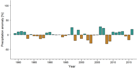
Precipitation anomaly in Mbe Mountains -
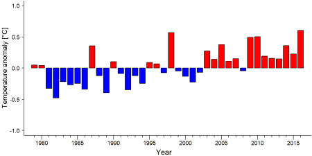
Temperature anomaly in Mbe Mountains


External links
References
Imong, I., Wood, K. L., & Dunn, A. (2010). Monitoring gorillas in Nigeria. Berggorilla & Regenwald Direkthilfe. https://www.berggorilla.org/en/home/news-archive/article-view/monitoring-gorillas-in-nigeria/
Imong, I., Eban, J., & Mengjo, C. (2014). Using technology to save gorillas in the Mbe Mountains. Gorilla Journal, 48, 16–17.
Shomkegh, S. A., Adaje, P. O., & Dagba, B. I. (2017). Assessment of community participation in forest resources management in Afi and Mbe Mountains, Cross River State, Nigeria. Journal of Environmental Science, Toxicology and Food Technology (IOSR-JESTFT), 11(12), 41–47.
WCS Nigeria. (n.d.). Mbe Mountains. Retrieved February 5, 2025, from https://nigeria.wcs.org/Wild-Places/Mbe-Mountains.aspx
Kiribou, R., Tehoda, P., Chukwu, O., Bempah, G., Kühl, H. S., Ferreira, J., …, & Heinicke, S. (2024). Exposure of African ape sites to climate change impacts. PLOS Climate, 3(2), e0000345. doi:10.1371/journal.pclm.0000345
Page created by: Priscilla Stanley Shao Date: 2024-11-25 10:42:00