
Mount Cameroon National Park: Difference between revisions
No edit summary |
No edit summary |
||
| Line 17: | Line 17: | ||
= Site characteristics = | = Site characteristics = | ||
Established in 2009, Mt. Cameroon National Park lies near the coast, in western Cameroon (Eno-Nku 2013). Harboring a very rich and diverse flora and fauna, the site is part of a biodiversity hotspot in the Gulf of Guinea Forests ([https://www.mtcameroonnationalpark.org/ MNCP]). Reaching 4,070 m in altitude, Mount Cameroon, also known as Mount Fako, is an active volcano and the highest peak in West and Central Africa, as well as the fourth most prominent peak in Africa ([https://www.mtcameroonnationalpark.org/ MNCP]). The western slope of the park is one of the wettest places in the world, with 10,000 mm rainfall ([https://www.mtcameroonnationalpark.org/ MNCP]). The park is home to forest elephants, chimpanzees, drills, and over 330 bird species, including two endemic species, the Mt. Cameroon francolin, [http://datazone.birdlife.org/species/factsheet/22678891 ''Pternistis camerunensis''] and Mt. Cameroon speirops, [http://datazone.birdlife.org/species/factsheet/mount-cameroon-speirops-zosterops-melanocephalus ''Zosterops melanocephalus''] ([https://cameroon.panda.org/places_landscapes/coastal_forests_programme/mt_cameroon_national_park/ WWF]). | Established in 2009, Mt. Cameroon National Park lies near the coast, in western Cameroon ([[#R01270|Eno-Nku 2013]]). Harboring a very rich and diverse flora and fauna, the site is part of a biodiversity hotspot in the Gulf of Guinea Forests ([https://www.mtcameroonnationalpark.org/ MNCP]). Reaching 4,070 m in altitude, Mount Cameroon, also known as Mount Fako, is an active volcano and the highest peak in West and Central Africa, as well as the fourth most prominent peak in Africa ([https://www.mtcameroonnationalpark.org/ MNCP]). The western slope of the park is one of the wettest places in the world, with 10,000 mm rainfall ([https://www.mtcameroonnationalpark.org/ MNCP]). The park is home to forest elephants, chimpanzees, drills, and over 330 bird species, including two endemic species, the Mt. Cameroon francolin, [http://datazone.birdlife.org/species/factsheet/22678891 ''Pternistis camerunensis''] and Mt. Cameroon speirops, [http://datazone.birdlife.org/species/factsheet/mount-cameroon-speirops-zosterops-melanocephalus ''Zosterops melanocephalus''] ([https://cameroon.panda.org/places_landscapes/coastal_forests_programme/mt_cameroon_national_park/ WWF]). | ||
'''Table 1. Basic site information for Mount Cameroon National Park''' | '''Table 1. Basic site information for Mount Cameroon National Park''' | ||
| Line 44: | Line 44: | ||
= Ape status = | = Ape status = | ||
A survey in 2013 estimated an abundance of 130 (95% CI: 79-215) chimpanzees; nests and signs of gorillas were not found (Eno-Nku 2013). Based on the 2013 estimates together with results from a 2007 survey, the chimpanzee population appeared to be stable (Eno-Nku 2013). Camera trap surveys in 2016 and 2017 indicate a higher abundance in the southern part of the park (Boekee & Robinson 2017). However, lower relative abundance from surveys in 2020 and onwards indicate that the chimpanzee population is under pressure (Kupsch and Sumbede 2023). | A survey in 2013 estimated an abundance of 130 (95% CI: 79-215) chimpanzees; nests and signs of gorillas were not found ([[#R01270|Eno-Nku 2013]]). Based on the 2013 estimates together with results from a 2007 survey, the chimpanzee population appeared to be stable ([[#R01270|Eno-Nku 2013]]). Camera trap surveys in 2016 and 2017 indicate a higher abundance in the southern part of the park ([[#R01269|Boekee & Robinson 2017]]). However, lower relative abundance from surveys in 2020 and onwards indicate that the chimpanzee population is under pressure ([[#R01271|Kupsch and Sumbede 2023]]). | ||
'''Table 2. Ape population estimates reported for Mount Cameroon National Park''' | '''Table 2. Ape population estimates reported for Mount Cameroon National Park''' | ||
| Line 70: | Line 70: | ||
|Reconnaissance walk | |Reconnaissance walk | ||
| | | | ||
|Kupsch et al. 2025 | |[[#R01272|Kupsch et al. 2025]] | ||
|Community-based, survey effort 194.6 hours, October-SeptemberJuly-December | |Community-based, survey effort 194.6 hours, October-SeptemberJuly-December | ||
| | | | ||
| Line 83: | Line 83: | ||
|Camera trap | |Camera trap | ||
| | | | ||
|Kupsch et al. 2025 | |[[#R01272|Kupsch et al. 2025]] | ||
|Survey effort 3,430 camera days, October-SeptemberJuly-October | |Survey effort 3,430 camera days, October-SeptemberJuly-October | ||
| | | | ||
| Line 96: | Line 96: | ||
|Reconnaissance walk | |Reconnaissance walk | ||
| | | | ||
|Kupsch et al. 2025 | |[[#R01272|Kupsch et al. 2025]] | ||
|Community-based, survey effort 277 hours, July October-December September | |Community-based, survey effort 277 hours, July October-December September | ||
| | | | ||
| Line 109: | Line 109: | ||
|Camera trap | |Camera trap | ||
| | | | ||
|Kupsch et al. 2025 | |[[#R01272|Kupsch et al. 2025]] | ||
|Survey effort 4,994 camera days, October-SeptemberJuly-October | |Survey effort 4,994 camera days, October-SeptemberJuly-October | ||
| | | | ||
| Line 122: | Line 122: | ||
|Camera trap | |Camera trap | ||
| | | | ||
|Kupsch and Sumbede 2023 | |[[#R01271|Kupsch and Sumbede 2023]] | ||
|Survey effort 2,208 camera days, July-December | |Survey effort 2,208 camera days, July-December | ||
| | | | ||
| Line 135: | Line 135: | ||
|Reconnaissance walk | |Reconnaissance walk | ||
| | | | ||
|Kupsch and Sumbede 2023 | |[[#R01271|Kupsch and Sumbede 2023]] | ||
|Survey effort 400.2 km, April-June | |Survey effort 400.2 km, April-June | ||
| | | | ||
| Line 148: | Line 148: | ||
|Camera trap | |Camera trap | ||
| | | | ||
|Kupsch and Sumbede 2023 | |[[#R01271|Kupsch and Sumbede 2023]] | ||
|Survey effort 3,470 camera days, July-December | |Survey effort 3,470 camera days, July-December | ||
| | | | ||
| Line 161: | Line 161: | ||
|Reconnaissance walk | |Reconnaissance walk | ||
| | | | ||
|Kupsch and Sumbede 2023 | |[[#R01271|Kupsch and Sumbede 2023]] | ||
|Survey effort 411.5 km, April-June | |Survey effort 411.5 km, April-June | ||
| | | | ||
| Line 174: | Line 174: | ||
|Camera trap | |Camera trap | ||
| | | | ||
|Boekee & Robinson 2017 | |[[#R01269|Boekee & Robinson 2017]] | ||
|Occupancy 0.24 (0.06); 60 TEAM Network protocol sites | |Occupancy 0.24 (0.06); 60 TEAM Network protocol sites | ||
| | | | ||
| Line 187: | Line 187: | ||
|Camera trap | |Camera trap | ||
| | | | ||
|Boekee & Robinson 2017 | |[[#R01269|Boekee & Robinson 2017]] | ||
|Occupancy 0.38 (0.11); 60 TEAM Network protocol sites | |Occupancy 0.38 (0.11); 60 TEAM Network protocol sites | ||
| | | | ||
| Line 200: | Line 200: | ||
|Line transects | |Line transects | ||
| | | | ||
|Eno-Nku 2013 | |[[#R01270|Eno-Nku 2013]] | ||
| | | | ||
| | | | ||
| Line 213: | Line 213: | ||
|Line transects | |Line transects | ||
| | | | ||
|Eno-Nku 2013 | |[[#R01270|Eno-Nku 2013]] | ||
| | | | ||
| | | | ||
| Line 222: | Line 222: | ||
= Threats = | = Threats = | ||
Main threats to great apes include hunting and logging. Encounter rate (nests/km)s of human pressure threats within the park decreased between 2007 and 2013 (Eno-Nku 2013). | Main threats to great apes include hunting and logging. Encounter rate (nests/km)s of human pressure threats within the park decreased between 2007 and 2013 ([[#R01270|Eno-Nku 2013]]). | ||
'''Table 3. Threats to apes reported for Mount Cameroon National Park''' | '''Table 3. Threats to apes reported for Mount Cameroon National Park''' | ||
| Line 235: | Line 235: | ||
|1.3 Tourism & recreation areas | |1.3 Tourism & recreation areas | ||
|Low (up to 30% of population affected) | |Low (up to 30% of population affected) | ||
|The park established several structures to host tourists ([ | |The park established several structures to host tourists ([[#R02007|MNCP]]). Some are in chimpanzee areas (in the southern part). But the structures (houses, trails, lookouts) as well as tourist numbers are low. | ||
|2009-Ongoing (2025) | |2009-Ongoing (2025) | ||
|- | |- | ||
| Line 241: | Line 241: | ||
|2.1 Annual & perennial non-timber crops | |2.1 Annual & perennial non-timber crops | ||
|Present (unknown severity) | |Present (unknown severity) | ||
|Agricultural encroachment (Eno-Nku 2013). | |Agricultural encroachment ([[#R01270|Eno-Nku 2013]]). | ||
|Ongoing (2013) | |Ongoing (2013) | ||
|- | |- | ||
| Line 247: | Line 247: | ||
|5.1 Hunting & collecting terrestrial animals | |5.1 Hunting & collecting terrestrial animals | ||
|High (more than 70% of population affected) | |High (more than 70% of population affected) | ||
|Signs of snares, gun shells, gun shots, hunting trails had the highest encounter rate for human activities (Eno-Nku 2013). Traps 2020: 0.9 enc/km +/- 0.05 (SE); 2022: 0.44 enc/km +/- 0.07 (SE); gunshot rate from passive acoustic monitoring 2020: 39.91 gs/100d) +/- 15.25 (SE); 2022: 4.22 gs/100d +/- 1.03 (SE). Gunshot rate relatively low compared to other parks, while trapping rates are high (Kupsch and Sumbede 2023). | |Signs of snares, gun shells, gun shots, hunting trails had the highest encounter rate for human activities ([[#R01270|Eno-Nku 2013]]). Traps 2020: 0.9 enc/km +/- 0.05 (SE); 2022: 0.44 enc/km +/- 0.07 (SE); gunshot rate from passive acoustic monitoring 2020: 39.91 gs/100d) +/- 15.25 (SE); 2022: 4.22 gs/100d +/- 1.03 (SE). Gunshot rate relatively low compared to other parks, while trapping rates are high ([[#R01271|Kupsch and Sumbede 2023]]). | ||
|2009-Ongoing (2023) | |2009-Ongoing (2023) | ||
|- | |- | ||
| Line 253: | Line 253: | ||
|5.3 Logging & wood harvesting | |5.3 Logging & wood harvesting | ||
|Medium (30-70% of population affected) | |Medium (30-70% of population affected) | ||
|Logging signs inside park area 2020: 0.01 enc/km +/- 0.01 (SE); 2022: 0.04 enc/km +/- 0.02 (SE). Logging signs are scarce inside the park area though it appears at the edges (Kupsch and Sumbede 2023). | |Logging signs inside park area 2020: 0.01 enc/km +/- 0.01 (SE); 2022: 0.04 enc/km +/- 0.02 (SE). Logging signs are scarce inside the park area though it appears at the edges ([[#R01271|Kupsch and Sumbede 2023]]). | ||
|2009-Ongoing (2023) | |2009-Ongoing (2023) | ||
|- | |- | ||
| Line 259: | Line 259: | ||
|6.2 War, civil unrest & military exercises | |6.2 War, civil unrest & military exercises | ||
|Present (unknown severity) | |Present (unknown severity) | ||
|Military-political crisis in the entire region affecting the northern part of the park (Kupsch and Sumbede 2023). | |Military-political crisis in the entire region affecting the northern part of the park ([[#R01271|Kupsch and Sumbede 2023]]). | ||
|2017-Ongoing (2023) | |2017-Ongoing (2023) | ||
|} | |} | ||
| Line 291: | Line 291: | ||
|2 Counter-wildlife crime | |2 Counter-wildlife crime | ||
|2.14 Employ hunters in the conservation sector to reduce their impact | |2.14 Employ hunters in the conservation sector to reduce their impact | ||
|Hunters work as research assistants and as surveyors in community-based wildlife monitoring (Kupsch & Sumbede 2023; Kupsch et al. 2025) | |Hunters work as research assistants and as surveyors in community-based wildlife monitoring ([[#R01271|Kupsch & Sumbede 2023]]; [[#R01272|Kupsch et al. 2025]]) | ||
| | | | ||
|2016-Ongoing (2025) | |2016-Ongoing (2025) | ||
| Line 342: | Line 342: | ||
= Challenges = | = Challenges = | ||
Since 2017, there has been a military-political crisis with a very poor security situation in the Anglophone regions of Cameroon, which has made law enforcement impossible in some areas, including the northern part of Mt. Cameroon National Park. For a long time and up to date, in times of higher tension, ecoguards and researchers could enter the north of the national park and most of the villages within and adjacent to it (Kupsch & Sumbede 2023). | Since 2017, there has been a military-political crisis with a very poor security situation in the Anglophone regions of Cameroon, which has made law enforcement impossible in some areas, including the northern part of Mt. Cameroon National Park. For a long time and up to date, in times of higher tension, ecoguards and researchers could enter the north of the national park and most of the villages within and adjacent to it ([[#R01271|Kupsch & Sumbede 2023]]). | ||
'''Table 5. Challenges reported for Mount Cameroon National Park''' | '''Table 5. Challenges reported for Mount Cameroon National Park''' | ||
| Line 353: | Line 353: | ||
|6 Safety and stability | |6 Safety and stability | ||
|6.3 Civil unrest/war | |6.3 Civil unrest/war | ||
|Kupsch & Sumbede 2023 | |[[#R01271|Kupsch & Sumbede 2023]] | ||
|2017-Ongoing (2023) | |2017-Ongoing (2023) | ||
|} | |} | ||
| Line 405: | Line 405: | ||
= Research activities = | = Research activities = | ||
Mt. Cameroon is located relatively close to Douala and thus an international airport. This has made the mountain a hotspot for ornithologists through tourism but along with it also research. National universities, such as Buea, Dschang and Yaoundé, but also several international academic institutions are active on the mountain in avifaunal research. However, systematic surveys of large mammals remained scarce or unsuccessful due to the challenging terrain (Eno-Nku 2013). Since the national park has been included as target area into the regional development program (PSMNR-SWR) after its creation in 2009, large mammal monitoring became one focus of the research on the mountain. Since 2016 the park has been surveyed with camera traps based on the TEAM Network protocol (Kelly and Orume 2017) and since 2020 regular in-field recce surveys are implemented through the bio-monitoring unit of PSMNR (Kupsch and Sumbede 2023). Moreover, since 2022 a continuous recce and camera-based community-based monitoring has been implemented in the southern section at Mt. Etinde, one of the hotspots of chimpanzee presence inside the park (Kupsch et al. 2025) | Mt. Cameroon is located relatively close to Douala and thus an international airport. This has made the mountain a hotspot for ornithologists through tourism but along with it also research. National universities, such as Buea, Dschang and Yaoundé, but also several international academic institutions are active on the mountain in avifaunal research. However, systematic surveys of large mammals remained scarce or unsuccessful due to the challenging terrain ([[#R01270|Eno-Nku 2013]]). Since the national park has been included as target area into the regional development program (PSMNR-SWR) after its creation in 2009, large mammal monitoring became one focus of the research on the mountain. Since 2016 the park has been surveyed with camera traps based on the TEAM Network protocol (Kelly and Orume 2017) and since 2020 regular in-field recce surveys are implemented through the bio-monitoring unit of PSMNR ([[#R01271|Kupsch and Sumbede 2023]]). Moreover, since 2022 a continuous recce and camera-based community-based monitoring has been implemented in the southern section at Mt. Etinde, one of the hotspots of chimpanzee presence inside the park ([[#R01272|Kupsch et al. 2025]]) | ||
| Line 439: | Line 439: | ||
= Exposure to climate change impacts = | = Exposure to climate change impacts = | ||
As part of a study on the exposure of African great ape sites to climate change impacts, Kiribou et al. (2024) extracted climate data and data on projected extreme climate impact events for the site. Climatological characteristics were derived from observation-based climate data provided by the Inter-Sectoral Impact Model Intercomparison Project (ISIMIP, www.isimip.org). Parameters were calculated as the average across each 30-year period. For 1981-2010, the EWEMBI dataset from ISIMIP2a was used. For the two future periods (2021-2050 and 2071-2099) ISIMIP2b climate data based on four CMIP5 global climate models were used. For future projections, two Representative Concentration Pathways (RCP) were used. RCP 2.6 is a scenario with strong mitigation measures in which global temperatures would likely rise below 2C. RCP 6.0 is a scenario with medium emissions in which global temperatures would likely rise up to 3C by 2100. For the number of days with heavy precipitation events, the 98th percentile of all precipitation days (>1mm/d) was calculated for the 1979-2013 reference period as a threshold for a heavy precipitation event. Then, for each year, the number of days above that threshold was derived. The figures on temperature and precipitation anomaly show the deviation from the mean temperature and mean precipitation for the 1979-2013 reference period. | As part of a study on the exposure of African great ape sites to climate change impacts, [[#R02273|Kiribou et al. (2024)]] extracted climate data and data on projected extreme climate impact events for the site. Climatological characteristics were derived from observation-based climate data provided by the Inter-Sectoral Impact Model Intercomparison Project (ISIMIP, www.isimip.org). Parameters were calculated as the average across each 30-year period. For 1981-2010, the EWEMBI dataset from ISIMIP2a was used. For the two future periods (2021-2050 and 2071-2099) ISIMIP2b climate data based on four CMIP5 global climate models were used. For future projections, two Representative Concentration Pathways (RCP) were used. RCP 2.6 is a scenario with strong mitigation measures in which global temperatures would likely rise below 2C. RCP 6.0 is a scenario with medium emissions in which global temperatures would likely rise up to 3C by 2100. For the number of days with heavy precipitation events, the 98th percentile of all precipitation days (>1mm/d) was calculated for the 1979-2013 reference period as a threshold for a heavy precipitation event. Then, for each year, the number of days above that threshold was derived. The figures on temperature and precipitation anomaly show the deviation from the mean temperature and mean precipitation for the 1979-2013 reference period. | ||
The estimated exposure to future extreme climate impact events (crop failure, drought, river flood, wildfire, tropical cyclone, and heatwave) is based on a published dataset by Lange et al. 2020 derived from ISIMIP2b data. The same global climate models and RCPs as described above were used. Within each 30-year period, the number of years with an extreme event and the average proportion of the site affected were calculated (Kiribou et al. 2024). | The estimated exposure to future extreme climate impact events (crop failure, drought, river flood, wildfire, tropical cyclone, and heatwave) is based on a published dataset by Lange et al. 2020 derived from ISIMIP2b data. The same global climate models and RCPs as described above were used. Within each 30-year period, the number of years with an extreme event and the average proportion of the site affected were calculated ([[#R02273|Kiribou et al. 2024]]). | ||
'''Table 8. Estimated past and projected climatological characteristics in Mount Cameroon National Park''' | '''Table 8. Estimated past and projected climatological characteristics in Mount Cameroon National Park''' | ||
| Line 564: | Line 564: | ||
= References = | = References = | ||
Boekee, K., & Orume, R. (2017). Camera trap survey report: Mount Cameroon National Park. Project report. PSMNR-SWR, Buea, Cameroon. 116 pp. | <span id="R01269"></span>Boekee, K., & Orume, R. (2017). Camera trap survey report: Mount Cameroon National Park. Project report. PSMNR-SWR, Buea, Cameroon. 116 pp. | ||
Eno-Nku, M. (2013). Large mammal surveys of the Mt. Cameroon National Park, | <span id="R01270"></span>Eno-Nku, M. (2013). Large mammal surveys of the Mt. Cameroon National Park, SW Region. WWF CCPO Coastal Forests Programme. | ||
Kupsch, D., & Sumbede, A. (2023). Camera, recce and acoustic monitoring of wildlife and human signs from 2020 to 2022 in three clusters in Mount Cameroon National Park. PSMNR-SWR bio-monitoring report. Buea, Cameroon. 85 pp. | <span id="R01271"></span>Kupsch, D., & Sumbede, A. (2023). Camera, recce and acoustic monitoring of wildlife and human signs from 2020 to 2022 in three clusters in Mount Cameroon National Park. PSMNR-SWR bio-monitoring report. Buea, Cameroon. 85 pp. | ||
Kupsch, D., Namolongo, E., Ngange, B., Nwese, S., & Sumbede, A. (2025). Community-based wildlife monitoring outcomes in 2024 in the Mt. Etinde hotspot in Mount Cameroon National Park. PSMNR-SWR bio-monitoring report. Buea, Cameroon. 37 pp. | <span id="R01272"></span>Kupsch, D., Namolongo, E., Ngange, B., Nwese, S., & Sumbede, A. (2025). Community-based wildlife monitoring outcomes in 2024 in the Mt. Etinde hotspot in Mount Cameroon National Park. PSMNR-SWR bio-monitoring report. Buea, Cameroon. 37 pp. | ||
Mount Cameroon National Park. (n.d.). Mount Cameroon National Park. https://www.mtcameroonnationalpark.org/ | <span id="R01273"></span>Mount Cameroon National Park. (n.d.). Mount Cameroon National Park. https://www.mtcameroonnationalpark.org/ | ||
Mt Cameroon National Park. (n.d.). WWF. https://cameroon.panda.org/places_landscapes/coastal_forests_programme/mt_cameroon_national_park/ < | <span id="R01274"></span>Mt Cameroon National Park. (n.d.). WWF. https://cameroon.panda.org/places_landscapes/coastal_forests_programme/mt_cameroon_national_park/ | ||
<span id="R02273"></span>Kiribou, R., Tehoda, P., Chukwu, O., Bempah, G., Kühl, H. S., Ferreira, J., …, & Heinicke, S. (2024). Exposure of African ape sites to climate change impacts. ''PLOS Climate'', 3(2), e0000345. [https://doi.org/10.1371/journal.pclm.0000345 doi:10.1371/journal.pclm.0000345] | |||
<span id="R02007"></span>MNCP. https://www.mtcameroonnationalpark.org/ | |||
Revision as of 16:29, 12 October 2026
Central Africa > Cameroon > Mount Cameroon National Park
Français | Português | Español | Bahasa Indonesia | Melayu
Summary
- Nigeria-Cameroon chimpanzees (Pan troglodytes ellioti) are present in Mount Cameroon National Park.
- It has been estimated that 130 (79-215) chimpanzees occur in the site; gorillas have not been recorded in the site in several years.
- The chimpanzee population trend is stable.
- The site has a total size of 581.78 km².
- Key threats to great apes are hunting and logging.
- Conservation activities have focused on community-based projects, eco-tourism and biomonitoring.
- At 4,070 m in altitude, Mount Cameroon is the highest peak in sub-Saharan western and central Africa.
Site characteristics
Established in 2009, Mt. Cameroon National Park lies near the coast, in western Cameroon (Eno-Nku 2013). Harboring a very rich and diverse flora and fauna, the site is part of a biodiversity hotspot in the Gulf of Guinea Forests (MNCP). Reaching 4,070 m in altitude, Mount Cameroon, also known as Mount Fako, is an active volcano and the highest peak in West and Central Africa, as well as the fourth most prominent peak in Africa (MNCP). The western slope of the park is one of the wettest places in the world, with 10,000 mm rainfall (MNCP). The park is home to forest elephants, chimpanzees, drills, and over 330 bird species, including two endemic species, the Mt. Cameroon francolin, Pternistis camerunensis and Mt. Cameroon speirops, Zosterops melanocephalus (WWF).
Table 1. Basic site information for Mount Cameroon National Park
| Species | Pan troglodytes ellioti |
| Area | 581.78 km² |
| Coordinates | Lat: 4.218726 , Lon: 9.146500 |
| Type of site | Protected area (National Park) |
| Habitat types | Subtropical/tropical dry forest, Grassland, Subtropical/tropical moist montane forest |
| Type of governance | Governance by government |
Types of sites Governance types Habitat types
Ape status
A survey in 2013 estimated an abundance of 130 (95% CI: 79-215) chimpanzees; nests and signs of gorillas were not found (Eno-Nku 2013). Based on the 2013 estimates together with results from a 2007 survey, the chimpanzee population appeared to be stable (Eno-Nku 2013). Camera trap surveys in 2016 and 2017 indicate a higher abundance in the southern part of the park (Boekee & Robinson 2017). However, lower relative abundance from surveys in 2020 and onwards indicate that the chimpanzee population is under pressure (Kupsch and Sumbede 2023).
Table 2. Ape population estimates reported for Mount Cameroon National Park
| Species | Year | Occurrence | Encounter or vistation rate (nests/km; ind/day) | Density estimate [ind./ km²] (95% CI) | Abundance estimate (95% CI) | Survey area | Sampling method | Analytical framework | Source | Comments | A.P.E.S. database ID |
|---|---|---|---|---|---|---|---|---|---|---|---|
| Pan troglodytes ellioti | 2023-2024 | 0.09 nest cluster enc/hour +/- 0.03 (SE) | Mt. Cameroon National Park; only Mt. Etinde (43.7 km²) | Reconnaissance walk | Kupsch et al. 2025 | Community-based, survey effort 194.6 hours, October-SeptemberJuly-December | |||||
| Pan troglodytes ellioti | 2023-2024 | 0.91 camera rec/100d +/- 0.2 (SE) | Mt. Cameroon National Park; only Mt. Etinde (43.7 km²) | Camera trap | Kupsch et al. 2025 | Survey effort 3,430 camera days, October-SeptemberJuly-October | |||||
| Pan troglodytes ellioti | 2022-2023 | 0.04 nest cluster enc/hour +/- 0.02 (SE) | Mt. Cameroon National Park; only Mt. Etinde (43.7 km²) | Reconnaissance walk | Kupsch et al. 2025 | Community-based, survey effort 277 hours, July October-December September | |||||
| Pan troglodytes ellioti | 2022-2023 | 0.81 camera rec/100d +/- 0.15 (SE) | Mt. Cameroon National Park; only Mt. Etinde (43.7 km²) | Camera trap | Kupsch et al. 2025 | Survey effort 4,994 camera days, October-SeptemberJuly-October | |||||
| Pan troglodytes ellioti | 2022 | 0.47 camera rec/100d +/- 0.25 (SE) | Mount Cameroon National Park | Camera trap | Kupsch and Sumbede 2023 | Survey effort 2,208 camera days, July-December | |||||
| Pan troglodytes ellioti | 2022 | 0.27 enc/km +/- 0.05 (SE) | Mount Cameroon National Park | Reconnaissance walk | Kupsch and Sumbede 2023 | Survey effort 400.2 km, April-June | |||||
| Pan troglodytes ellioti | 2020 | 0.49 camera rec/100d +/- 0.13 (SE) | Mount Cameroon National Park | Camera trap | Kupsch and Sumbede 2023 | Survey effort 3,470 camera days, July-December | |||||
| Pan troglodytes ellioti | 2020 | 0.47 enc/km +/- 0.09 (SE) | Mount Cameroon National Park | Reconnaissance walk | Kupsch and Sumbede 2023 | Survey effort 411.5 km, April-June | |||||
| Pan troglodytes ellioti | 2016-2017 | 1.67 camera rec/100d | Mount Cameroon National Park | Camera trap | Boekee & Robinson 2017 | Occupancy 0.24 (0.06); 60 TEAM Network protocol sites | |||||
| Pan troglodytes ellioti | 2016 | 1.43 camera rec/100d | Mount Cameroon National Park | Camera trap | Boekee & Robinson 2017 | Occupancy 0.38 (0.11); 60 TEAM Network protocol sites | |||||
| Pan troglodytes ellioti | 2013 | 1.21 | 0.67 (0.41-1.11) | 130 (79-215) | Mt. Cameroon National Park, excluding southwest block | Line transects | Eno-Nku 2013 | ||||
| Pan troglodytes ellioti | 2007 | 0.47 (0.17-0.136) | Mt. Cameroon proposed National Park | Line transects | Eno-Nku 2013 |
Sampling methods Analytical frameworks
Threats
Main threats to great apes include hunting and logging. Encounter rate (nests/km)s of human pressure threats within the park decreased between 2007 and 2013 (Eno-Nku 2013).
Table 3. Threats to apes reported for Mount Cameroon National Park
| Category | Specific threats | Threat level | Description | Year of threat |
|---|---|---|---|---|
| 1 Residential & commercial development | 1.3 Tourism & recreation areas | Low (up to 30% of population affected) | The park established several structures to host tourists (MNCP). Some are in chimpanzee areas (in the southern part). But the structures (houses, trails, lookouts) as well as tourist numbers are low. | 2009-Ongoing (2025) |
| 2 Agriculture & aquaculture | 2.1 Annual & perennial non-timber crops | Present (unknown severity) | Agricultural encroachment (Eno-Nku 2013). | Ongoing (2013) |
| 5 Biological resource use | 5.1 Hunting & collecting terrestrial animals | High (more than 70% of population affected) | Signs of snares, gun shells, gun shots, hunting trails had the highest encounter rate for human activities (Eno-Nku 2013). Traps 2020: 0.9 enc/km +/- 0.05 (SE); 2022: 0.44 enc/km +/- 0.07 (SE); gunshot rate from passive acoustic monitoring 2020: 39.91 gs/100d) +/- 15.25 (SE); 2022: 4.22 gs/100d +/- 1.03 (SE). Gunshot rate relatively low compared to other parks, while trapping rates are high (Kupsch and Sumbede 2023). | 2009-Ongoing (2023) |
| 5 Biological resource use | 5.3 Logging & wood harvesting | Medium (30-70% of population affected) | Logging signs inside park area 2020: 0.01 enc/km +/- 0.01 (SE); 2022: 0.04 enc/km +/- 0.02 (SE). Logging signs are scarce inside the park area though it appears at the edges (Kupsch and Sumbede 2023). | 2009-Ongoing (2023) |
| 6 Human intrusions & disturbance | 6.2 War, civil unrest & military exercises | Present (unknown severity) | Military-political crisis in the entire region affecting the northern part of the park (Kupsch and Sumbede 2023). | 2017-Ongoing (2023) |
Conservation activities
The National park is working with Village Forest Management Committees (VFMCs) of the 41 communities around the park. These communities have been regrouped into clusters. Each cluster has a cluster facilitator, a person who maintains communication between the park and the cluster. Inside the National Park territory each cluster is co-responsible for the management of a “Cluster Conservation Zone” (MNCP). On half-yearly cluster platform meetings representatives of the VFMCs plan and agree on co-management activities (e.g. boundary opening and monitoring activities), and evaluate past performance (MCNP). The communities equally receive a conservation bonus, depending on their performance in co-management activities and the occurrence of illegal activities in their cluster conservation zone. The conservation bonus is used to sponsor small community projects. The National park is managing the Non-Timber Forest Product (NTFP) of ``Prunus Africana`` bark in a sustainable way. Local communities insisted on further exploitation of the Prunus Resource as a user right during the process leading to the creation of Mt. Cameroon National Park. Mount Cameroon hosts one of the largest populations of ``Prunus africana`` in Cameroon. The tree is occurring mainly in the mountain forest close to the border of the savannah. The Prunus bark is used as traditional medicine and since the 1970s in the pharmaceutical industry in Europe to treat benign prostate (MNCP).
Table 4. Conservation activities reported for Mount Cameroon National Park
| Category | Specific activity | Description | Implementing organization(s) | Year of activity |
|---|---|---|---|---|
| 2 Counter-wildlife crime | 2.11 Implement monitoring surveillance strategies (e.g., SMART) or use monitoring data to improve effectiveness of patrols | Regular surveys on wildlife and human activities are conducted through PSMNR-SWR (n.d.). | Ongoing (2025) | |
| 2 Counter-wildlife crime | 2.13 Provide sustainable alternative livelihoods; establish fish- or domestic meat farms | Various activities in 41 target communities under PSMNR-SWR (n.d.), e.g. farmers training, vocational training, tree nurseries, piggeries, bee keeping, cassava mills. | 2009-Ongoing (2025) | |
| 2 Counter-wildlife crime | 2.14 Employ hunters in the conservation sector to reduce their impact | Hunters work as research assistants and as surveyors in community-based wildlife monitoring (Kupsch & Sumbede 2023; Kupsch et al. 2025) | 2016-Ongoing (2025) | |
| 2 Counter-wildlife crime | 2.3 Conduct regular anti-poaching patrols | Eco-guards patrol park (MCNP). | Ongoing (2025) | |
| 2 Counter-wildlife crime | 2.6 Regularly de-activate/remove ground snares | Joint activities of community members and park-staff (PSMNR-SWR n.d.) | 2022-Ongoing (2025) | |
| 4 Education & awareness | 4.1 Educate local communities about apes and sustainable use | Conservation education programmes for school classes through PSMNR (n.d.) | 2018-Ongoing (2025) | |
| 5 Protection & restoration | 5.2 Legally protect ape habitat | The park was established in 2009. | 2009-Ongoing (2026) | |
| 7 Economic & other incentives | 7.2 Provide non-monetary benefits to local communities for sustainably managing their forest and its wildlife (e.g., better education, infrastructure development) | Scholarships, community infrastructure development, green initiatives e.g. bee farming, small scale poultry and non-timber products value chain improvement (PSMNR-SWR n.d.) | 2009-Ongoing (2025) | |
| 8 Permanent presence | 8.2 Run tourist projects and ensure permanent human presence at site | The park has authorized local tour operators and activities such as trekking, bird watching and viewing wildlife (MCNP). | Ongoing (2023) | |
| 8 Permanent presence | 8.2 Run tourist projects and ensure permanent human presence at site | The park has authorized local tour operators and activities such as trekking, bird watching and viewing wildlife (MCNP). | Ongoing (2025) |
Challenges
Since 2017, there has been a military-political crisis with a very poor security situation in the Anglophone regions of Cameroon, which has made law enforcement impossible in some areas, including the northern part of Mt. Cameroon National Park. For a long time and up to date, in times of higher tension, ecoguards and researchers could enter the north of the national park and most of the villages within and adjacent to it (Kupsch & Sumbede 2023).
Table 5. Challenges reported for Mount Cameroon National Park
| Challenges | Specific challenges | Source | Year(s) |
|---|---|---|---|
| 6 Safety and stability | 6.3 Civil unrest/war | Kupsch & Sumbede 2023 | 2017-Ongoing (2023) |
Enablers
Table 6. Enablers reported for Mount Cameroon National Park
| Enablers | Specific enablers | Source | Year(s) |
|---|---|---|---|
| 1 Site management | |||
| 2 Resources and capacity | |||
| 3 Engaged community | |||
| 4 Institutional support | |||
| 5 Ecological context | |||
| 6 Safety and stability |
Research activities
Mt. Cameroon is located relatively close to Douala and thus an international airport. This has made the mountain a hotspot for ornithologists through tourism but along with it also research. National universities, such as Buea, Dschang and Yaoundé, but also several international academic institutions are active on the mountain in avifaunal research. However, systematic surveys of large mammals remained scarce or unsuccessful due to the challenging terrain (Eno-Nku 2013). Since the national park has been included as target area into the regional development program (PSMNR-SWR) after its creation in 2009, large mammal monitoring became one focus of the research on the mountain. Since 2016 the park has been surveyed with camera traps based on the TEAM Network protocol (Kelly and Orume 2017) and since 2020 regular in-field recce surveys are implemented through the bio-monitoring unit of PSMNR (Kupsch and Sumbede 2023). Moreover, since 2022 a continuous recce and camera-based community-based monitoring has been implemented in the southern section at Mt. Etinde, one of the hotspots of chimpanzee presence inside the park (Kupsch et al. 2025)
Documented behaviours
Table 7. Behaviours documented for Mount Cameroon National Park
| Category | Behavior | Observation type | Prevalence | Observation dates | Source | Habituation | Species | Comment |
|---|---|---|---|---|---|---|---|---|
| Not reported |
Exposure to climate change impacts
As part of a study on the exposure of African great ape sites to climate change impacts, Kiribou et al. (2024) extracted climate data and data on projected extreme climate impact events for the site. Climatological characteristics were derived from observation-based climate data provided by the Inter-Sectoral Impact Model Intercomparison Project (ISIMIP, www.isimip.org). Parameters were calculated as the average across each 30-year period. For 1981-2010, the EWEMBI dataset from ISIMIP2a was used. For the two future periods (2021-2050 and 2071-2099) ISIMIP2b climate data based on four CMIP5 global climate models were used. For future projections, two Representative Concentration Pathways (RCP) were used. RCP 2.6 is a scenario with strong mitigation measures in which global temperatures would likely rise below 2C. RCP 6.0 is a scenario with medium emissions in which global temperatures would likely rise up to 3C by 2100. For the number of days with heavy precipitation events, the 98th percentile of all precipitation days (>1mm/d) was calculated for the 1979-2013 reference period as a threshold for a heavy precipitation event. Then, for each year, the number of days above that threshold was derived. The figures on temperature and precipitation anomaly show the deviation from the mean temperature and mean precipitation for the 1979-2013 reference period.
The estimated exposure to future extreme climate impact events (crop failure, drought, river flood, wildfire, tropical cyclone, and heatwave) is based on a published dataset by Lange et al. 2020 derived from ISIMIP2b data. The same global climate models and RCPs as described above were used. Within each 30-year period, the number of years with an extreme event and the average proportion of the site affected were calculated (Kiribou et al. 2024).
Table 8. Estimated past and projected climatological characteristics in Mount Cameroon National Park
| Value | 1981-2010 | 2021-2050, RCP 2.6 | 2021-2050, RCP 6.0 | 2071-2099, RCP 2.6 | 2071-2099, RCP 6.0 |
|---|---|---|---|---|---|
| Mean temperature [C] | 23.9 | 25 | 24.9 | 25.1 | 26.2 |
| Annual precipitation [mm] | 2529 | 2616 | 2663 | 2660 | 2625 |
| Max no. consecutive dry days (per year) | 43.6 | 28 | 29.5 | 25.5 | 31.3 |
| No. days with heavy precipitation (per year) | 6.2 | 6 | 6.7 | 7.2 | 6.8 |
Table 9. Projected exposure of apes to extreme climate impact events in Mount Cameroon National Park
| Type | No. of years with event (2021-2050, RCP 2.6) | % of site exposed (2021-2050, RCP 2.6) | No. of years with event (2021-2050, RCP 6.0) | % of site exposed (2021-2050, RCP 6.0) | No. of years with event (2070-2099, RCP 2.6) | % of site exposed (2070-2099, RCP 2.6) | No. of years with event (2070-2099, RCP 6.0) | % of site exposed (2070-2099, RCP 6.0) |
|---|---|---|---|---|---|---|---|---|
| Crop failure | 5 | 0.64 | 4 | 0.57 | 3 | 0.95 | 6 | 0.81 |
| Drought | 0 | 0 | 0 | 0 | 0 | 0 | 0 | 0 |
| Heatwave | 0 | 0 | 0.5 | 50 | 1.5 | 100 | 3.5 | 100 |
| River flood | 2.25 | 0.51 | 0.5 | 0.03 | 1.75 | 1.76 | 4 | 1.47 |
| Tropical cyclone | 0 | 0 | 0 | 0 | 0 | 0 | 0 | 0 |
| Wildfire | 30 | 0.41 | 30 | 0.42 | 29 | 0.41 | 29 | 0.44 |
-
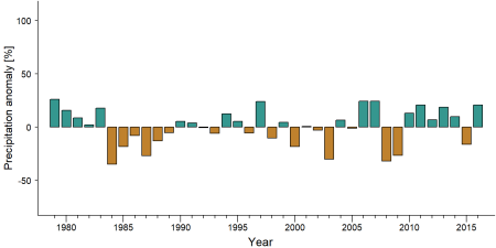
Precipitation anomaly in Mount Cameroon National Park -
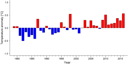
Temperature anomaly in Mount Cameroon National Park


External links
Mount Cameroon National Park official website)
References
Boekee, K., & Orume, R. (2017). Camera trap survey report: Mount Cameroon National Park. Project report. PSMNR-SWR, Buea, Cameroon. 116 pp.
Eno-Nku, M. (2013). Large mammal surveys of the Mt. Cameroon National Park, SW Region. WWF CCPO Coastal Forests Programme.
Kupsch, D., & Sumbede, A. (2023). Camera, recce and acoustic monitoring of wildlife and human signs from 2020 to 2022 in three clusters in Mount Cameroon National Park. PSMNR-SWR bio-monitoring report. Buea, Cameroon. 85 pp.
Kupsch, D., Namolongo, E., Ngange, B., Nwese, S., & Sumbede, A. (2025). Community-based wildlife monitoring outcomes in 2024 in the Mt. Etinde hotspot in Mount Cameroon National Park. PSMNR-SWR bio-monitoring report. Buea, Cameroon. 37 pp.
Mount Cameroon National Park. (n.d.). Mount Cameroon National Park. https://www.mtcameroonnationalpark.org/
Mt Cameroon National Park. (n.d.). WWF. https://cameroon.panda.org/places_landscapes/coastal_forests_programme/mt_cameroon_national_park/
Kiribou, R., Tehoda, P., Chukwu, O., Bempah, G., Kühl, H. S., Ferreira, J., …, & Heinicke, S. (2024). Exposure of African ape sites to climate change impacts. PLOS Climate, 3(2), e0000345. doi:10.1371/journal.pclm.0000345
MNCP. https://www.mtcameroonnationalpark.org/
Page created by: APES Atlas Team Date: 2021-09-28
Page updated by: Denish Kupsch & Anthoine Sumbede Date: 2025-08-25