
Mamiri Forest Reserve
West Africa > Ghana > Mamiri Forest Reserve
Français | Português | Español | Bahasa Indonesia | Melayu
Summary
- Western chimpanzees (Pan troglodytes verus) may be present in Mamiri Forest Reserve.
- No chimpanzees were recorded in the last survey.
- The chimpanzee population trend is decreasing.
- The site has a total size of 45 km².
- Key threats to chimpanzees are hunting and presence of farms and plantations.
- Conservation activities are not documented.
Site characteristics
Mamiri Forest Reserve is located in western Ghana, near the town of Sureso, and it is connected to Fure Headwaters Forest Reserve in the south. The reserve was established in 1949. It was first logged in 1973, and in 1996, Samartex was granted a 40-year concession. The northern part of the reserve remains mostly intact, but forest in the south is degraded and fragmented. Areas bordering the northern part of the reserve are designated as a Hill Sanctuary. Mamiri's landscape contains a swampy valley and hills in the northern part (Gatti 2009). The site was declared an Important Bird Area in 2001 (BirdLife International 2022).
Table 1. Basic site information for Mamiri Forest Reserve
| Species | Pan troglodytes verus |
| Area | 45 km² |
| Coordinates | Lat: 5.666274 , Lon: -2.349749 |
| Type of site | Protected area (Forest Reserve) |
| Habitat types | Subtropical/tropical moist lowland forest |
| Type of governance |
Types of sites Governance types Habitat types
Ape status
The last survey to confirm chimpanzee presence was in 2005 (Oates 2006). A rapid survey was conducted at the site in 2009 in the context of the Wildlife Wood Project in Ghana, which aims to assist logging companies in improving wildlife management in concession areas (Gatti 2009). No signs of chimpanzees were recorded.
Table 2. Ape population estimates reported for Mamiri Forest Reserve
| Species | Year | Occurrence | Encounter or vistation rate (nests/km; ind/day) | Density estimate [ind./ km²] (95% CI) | Abundance estimate (95% CI) | Survey area | Sampling method | Analytical framework | Source | Comments | A.P.E.S. database ID |
|---|---|---|---|---|---|---|---|---|---|---|---|
| Pan troglodytes verus | 2009 | 0 | Mamiri Forest Reserve | Camera trap, Reconnaissance walk | Gatti 2009 | survey effort: 88.67 km | GHA0001, GHA0007 GHA0012, GHA0024, GHA0027, GHA0028, GHA0029
|
Sampling methods Analytical frameworks
Threats
Table 3. Threats to apes reported for Mamiri Forest Reserve
| Category | Specific threats | Threat level | Description | Year of threat |
|---|---|---|---|---|
| 2 Agriculture & aquaculture | 2.2 Wood & pulp plantations | Present (unknown severity) | The site includes c.2.3 ha of plantation and a few farms (BirdLife International 2022). | Ongoing (2022) |
| 5 Biological resource use | 5.1 Hunting & collecting terrestrial animals | High (more than 70% of population affected) | Hunting has severely impacted wildlife in the reserve (Gatti 2009). | Ongoing (2009) |
| 5 Biological resource use | 5.3 Logging & wood harvesting | Present (unknown severity) | Mamiri was first logged in 1973. In 1996, Samartex was granted a 40-year concession (Gatti 2009). | 1973 |
Conservation activities
Challenges
Table 5. Challenges reported for Mamiri Forest Reserve
| Challenges | Specific challenges | Source | Year(s) |
|---|---|---|---|
| Not reported |
Enablers
Table 6. Enablers reported for Mamiri Forest Reserve
| Enablers | Specific enablers | Source | Year(s) |
|---|---|---|---|
| 1 Site management | |||
| 2 Resources and capacity | |||
| 3 Engaged community | |||
| 4 Institutional support | |||
| 5 Ecological context | |||
| 6 Safety and stability |
Research activities
Documented behaviours
Table 7. Behaviours documented for Mamiri Forest Reserve
| Category | Behavior | Observation type | Prevalence | Observation dates | Source | Habituation | Species | Comment |
|---|---|---|---|---|---|---|---|---|
| Not reported |
Exposure to climate change impacts
As part of a study on the exposure of African great ape sites to climate change impacts, Kiribou et al. (2024) extracted climate data and data on projected extreme climate impact events for the site. Climatological characteristics were derived from observation-based climate data provided by the Inter-Sectoral Impact Model Intercomparison Project (ISIMIP, www.isimip.org). Parameters were calculated as the average across each 30-year period. For 1981-2010, the EWEMBI dataset from ISIMIP2a was used. For the two future periods (2021-2050 and 2071-2099) ISIMIP2b climate data based on four CMIP5 global climate models were used. For future projections, two Representative Concentration Pathways (RCP) were used. RCP 2.6 is a scenario with strong mitigation measures in which global temperatures would likely rise below 2C. RCP 6.0 is a scenario with medium emissions in which global temperatures would likely rise up to 3C by 2100. For the number of days with heavy precipitation events, the 98th percentile of all precipitation days (>1mm/d) was calculated for the 1979-2013 reference period as a threshold for a heavy precipitation event. Then, for each year, the number of days above that threshold was derived. The figures on temperature and precipitation anomaly show the deviation from the mean temperature and mean precipitation for the 1979-2013 reference period.
The estimated exposure to future extreme climate impact events (crop failure, drought, river flood, wildfire, tropical cyclone, and heatwave) is based on a published dataset by Lange et al. 2020 derived from ISIMIP2b data. The same global climate models and RCPs as described above were used. Within each 30-year period, the number of years with an extreme event and the average proportion of the site affected were calculated (Kiribou et al. 2024).
Table 8. Estimated past and projected climatological characteristics in Mamiri Forest Reserve
| Value | 1981-2010 | 2021-2050, RCP 2.6 | 2021-2050, RCP 6.0 | 2071-2099, RCP 2.6 | 2071-2099, RCP 6.0 |
|---|---|---|---|---|---|
| Mean temperature [C] | 27.2 | 28.3 | 28 | 28.4 | 29.5 |
| Annual precipitation [mm] | 1509 | 1442 | 1515 | 1460 | 1520 |
| Max no. consecutive dry days (per year) | 25.4 | 21 | 24.3 | 24.8 | 23.7 |
| No. days with heavy precipitation (per year) | 6.6 | 6.9 | 7.7 | 7.5 | 10.8 |
Table 9. Projected exposure of apes to extreme climate impact events in Mamiri Forest Reserve
| Type | No. of years with event (2021-2050, RCP 2.6) | % of site exposed (2021-2050, RCP 2.6) | No. of years with event (2021-2050, RCP 6.0) | % of site exposed (2021-2050, RCP 6.0) | No. of years with event (2070-2099, RCP 2.6) | % of site exposed (2070-2099, RCP 2.6) | No. of years with event (2070-2099, RCP 6.0) | % of site exposed (2070-2099, RCP 6.0) |
|---|---|---|---|---|---|---|---|---|
| Crop failure | 1 | 5.46 | 0.5 | 2.73 | 1 | 5.46 | 3.5 | 5.46 |
| Drought | 1.75 | 50 | 1 | 75 | 0 | 0 | 1 | 100 |
| Heatwave | 10.5 | 100 | 11 | 100 | 9.5 | 50 | 5.5 | 100 |
| River flood | 0.5 | 0.46 | 0.5 | 0.18 | 0.5 | 0.09 | 1 | 2.07 |
| Tropical cyclone | 0 | 0 | 0 | 0 | 0 | 0 | 0.5 | 3.07 |
| Wildfire | 30 | 0.23 | 30 | 0.22 | 29 | 0.21 | 29 | 0.2 |
-
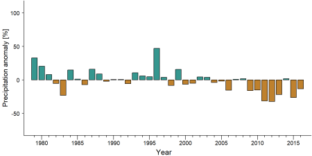
Precipitation anomaly in Mamiri Forest Reserve -
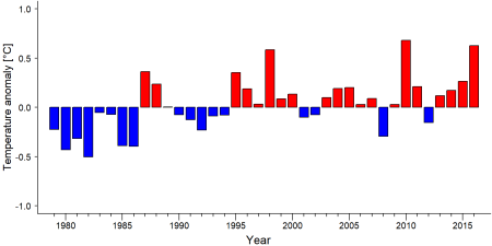
Temperature anomaly in Mamiri Forest Reserve


External links
References
BirdLife International (2022) Important Bird Areas factsheet: Mamiri Forest Reserve. Downloaded from http://www.birdlife.org on 15/03/2022.
Gatti, S. (2009). Mammal surveys and capacity building for the Wildlife Wood Project - Ghana. Unpublished report to the WWP-Ghana.
Oates, J. (2006) Primate Conservation in the Forests of Western Ghana. Unpublished report to the Wildlife Division, Forestry Commission, Ghana.
Kiribou, R., Tehoda, P., Chukwu, O., Bempah, G., Kühl, H. S., Ferreira, J., …, & Heinicke, S. (2024). Exposure of African ape sites to climate change impacts. PLOS Climate, 3(2), e0000345. doi:10.1371/journal.pclm.0000345
Page created by: APES Atlas Team Date: 2022-03-18