
Bong Mountain Proposed Protected Area
West Africa > Liberia > Bong Mountain Proposed Protected Area
Français | Português | Español | Bahasa Indonesia | Melayu
Summary
- Western chimpanzees (Pan troglodytes verus) are probably no longer present in Bong Mountain Proposed Protected Area.
- This site has a total size of 248.12 km².
- Key threat to chimpanzees is mining.
- Conservation activities were not reported.
- The area has been designated an International Bird Area (IBA) and been proposed for a Key Biodiversity Area (KBA) by the Critical Ecosystem Partnership Fund (CEPF).
Site characteristics
Bong Mountain Proposed Protected Area is located in Bong county in central Liberia. The area has partially been deforested, especially along the edges (Christie et al. 2007). The area has also been affected by mining of the China Union Project (Johnson 2015). Bong Mountain has a core of steep land with a narrow zone of closed dense forest, but also has existing roads, a moderate population density on the margins, and a potential for iron ore production (Johnson 2015). Johnson (2015) mentions in her report that the boundaries of the Bong Mountain Proposed Protected Area have been altered by the Forestry Development Authority in Liberia due to the mining operations that are/will be taking place in the area. Neither information on the altered geographical extent of this site, nor the flora and fauna in this area could be found.
Table 1. Basic site information for Bong Mountain Proposed Protected Area
| Species | Pan troglodytes verus |
| Area | 248.12 km² |
| Coordinates | Lat: 6.87 , Lon: -10.14 |
| Type of site | Proposed protected area |
| Habitat types | Subtropical/tropical moist montane forest, Subtropical/tropical heavily degraded former forest, Urban areas |
| Type of governance |
Types of sites Governance types Habitat types
Ape status
It is likely that chimpanzees have become extinct at this site, as the area around Bong Mountain Proposed Protected Area has been almost completely deforested (Christie et al. 2017, Junker pers. obs.) and because much of the site is currently being mined for iron ore (Johnson 2015). The nationwide chimpanzee abundance model published by Junker et al. (2015) suggests that chimpanzees are likely to be absent from this area. However, no chimpanzee surveys have been conducted at this site. Because the entire Bong Mountain Proposed Protected Area has been proclaimed a mining site (Johnson 2015), it will probably no longer be considered a protected area in the future.
Table 2. Ape population estimates reported for Bong Mountain Proposed Protected Area
| Species | Year | Occurrence | Encounter or vistation rate (nests/km; ind/day) | Density estimate [ind./ km²] (95% CI) | Abundance estimate (95% CI) | Survey area | Sampling method | Analytical framework | Source | Comments | A.P.E.S. database ID |
|---|---|---|---|---|---|---|---|---|---|---|---|
| Pan troglodytes verus | 2010-2012 | Bong Mountain Proposed Protected Area | Survey data | Predictive model | Junker et al. 2015 | Likely to be absent. The site itself was not surveyed, estimate based on a nationwide chimpanzee abundance model. |
Sampling methods Analytical frameworks
Threats
The southern part (about one third of the total area) of Bong Mountain Proposed Protected Area has been sold to a mining company, namely China Union Mining Co. The commodity that is being mined is iron ore. The total area of the mining site is 610 km2 (Wilson et al. 2017). The license type is a Class A mining license, which entails that mining is permitted in the proposed production area (no size limit) for at least 25 years (Wilson et al. 2017). The remaining part of Bong Mountain Proposed Protected Area is under a Development Exploration License (DEL), which means that the license holder has to submit a proposed exploration program to the Minister of Land, Mines, and Energy within 90 days-, and shall commence exploration within 180 days after the issuance of an exploration license (Wilson et al. 2017). The company started production in early 2014 to June 2015, but later suspended operations in late 2015, as a result of the twin shock - Ebola virus disease in Liberia and the price of iron ore. The water in the area is heavily polluted, because of seepage of heavy metals from the iron ore mine into local creeks, wells and groundwater (Wilson et al. 2017).
Table 3. Threats to apes reported for Bong Mountain Proposed Protected Area
| Category | Specific threats | Threat level | Description | Year of threat |
|---|---|---|---|---|
| 3 Energy production & mining | 3.2 Mining & quarrying | High (more than 70% of population affected) | Open pit mining for iron ore, Class A Exploration License and DEL issued in 2014 (Johnson 2015, Wilson et al. 2017) | 2014-Ongoing (2017) |
| 9 Pollution | 9.2 Industrial & military effluents | High (more than 70% of population affected) | Seepage from mining, six water samples were taken, iron, aluminium, calcium, boron, phosphorous, chromium, arsenic, and zinc were present in high concentrations (Wilson et al. 2017) | 2014-Ongoing (2017) |
Conservation activities
No conservation activities have been reported for the site.
Challenges
No information on challenges has been documented.
Table 5. Challenges reported for Bong Mountain Proposed Protected Area
| Challenges | Specific challenges | Source | Year(s) |
|---|---|---|---|
| Not reported |
Enablers
Table 6. Enablers reported for Bong Mountain Proposed Protected Area
| Enablers | Specific enablers | Source | Year(s) |
|---|---|---|---|
| 1 Site management | |||
| 2 Resources and capacity | |||
| 3 Engaged community | |||
| 4 Institutional support | |||
| 5 Ecological context | |||
| 6 Safety and stability |
Research activities
No information on research activities has been documented.
Documented behaviours
Table 7. Behaviours documented for Bong Mountain Proposed Protected Area
| Category | Behavior | Observation type | Prevalence | Observation dates | Source | Habituation | Species | Comment |
|---|---|---|---|---|---|---|---|---|
| Not reported |
Exposure to climate change impacts
As part of a study on the exposure of African great ape sites to climate change impacts, Kiribou et al. subm. extracted climate data and data on projected extreme climate impact events for the site. Climatological characteristics were derived from observation-based climate data provided by the Inter-Sectoral Impact Model Intercomparison Project (ISIMIP, www.isimip.org). Parameters were calculated as the average across each 30-year period. For 1981-2010, the EWEMBI dataset from ISIMIP2a was used. For the two future periods (2021-2050 and 2071-2099) ISIMIP2b climate data based on four CMIP5 global climate models were used. For future projections, two Representative Concentration Pathways (RCP) were used. RCP 2.6 is a scenario with strong mitigation measures in which global temperatures would likely rise below 2C. RCP 6.0 is a scenario with medium emissions in which global temperatures would likely rise up to 3C by 2100. For the number of days with heavy precipitation events, the 98th percentile of all precipitation days (>1mm/d) was calculated for the 1979-2013 reference period as a threshold for a heavy precipitation event. Then, for each year, the number of days above that threshold was derived. The figures on temperature and precipitation anomaly show the deviation from the mean temperature and mean precipitation for the 1979-2013 reference period.
The estimated exposure to future extreme climate impact events (crop failure, drought, river flood, wildfire, tropical cyclone, and heatwave) is based on a published dataset by Lange et al. 2020 derived from ISIMIP2b data. The same global climate models and RCPs as described above were used. Within each 30-year period, the number of years with an extreme event and the average proportion of the site affected were calculated (see Kiribou et al. subm. for details).
Table 8. Estimated past and projected climatological characteristics in Bong Mountain Proposed Protected Area
| Value | 1981-2010 | 2021-2050, RCP 2.6 | 2021-2050, RCP 6.0 | 2071-2099, RCP 2.6 | 2071-2099, RCP 6.0 |
|---|---|---|---|---|---|
| Mean temperature [C] | 25 | 26.1 | 26.1 | 26.2 | 27.2 |
| Annual precipitation [mm] | 2737 | 2802 | 2877 | 2829 | 2907 |
| Max no. consecutive dry days (per year) | 16.4 | 25.1 | 24 | 25.1 | 27.5 |
| No. days with heavy precipitation (per year) | 6.4 | 7.5 | 7.8 | 7.9 | 8.9 |
Table 9. Projected exposure of apes to extreme climate impact events in Bong Mountain Proposed Protected Area
| Type | No. of years with event (2021-2050, RCP 2.6) | % of site exposed (2021-2050, RCP 2.6) | No. of years with event (2021-2050, RCP 6.0) | % of site exposed (2021-2050, RCP 6.0) | No. of years with event (2070-2099, RCP 2.6) | % of site exposed (2070-2099, RCP 2.6) | No. of years with event (2070-2099, RCP 6.0) | % of site exposed (2070-2099, RCP 6.0) |
|---|---|---|---|---|---|---|---|---|
| Crop failure | 4 | 0.24 | 4.5 | 0.24 | 3 | 0.24 | 5 | 0.24 |
| Drought | 0 | 0 | 0 | 0 | 0 | 0 | 0 | 0 |
| Heatwave | 9 | 100 | 6.5 | 100 | 13 | 100 | 18.5 | 100 |
| River flood | 3 | 2.13 | 2.75 | 1.2 | 3 | 1 | 7 | 2.44 |
| Tropical cyclone | 0 | 0 | 0.5 | 1.37 | 0 | 0 | 0.5 | 0.09 |
| Wildfire | 30 | 0.29 | 30 | 0.26 | 29 | 0.3 | 29 | 0.28 |
-
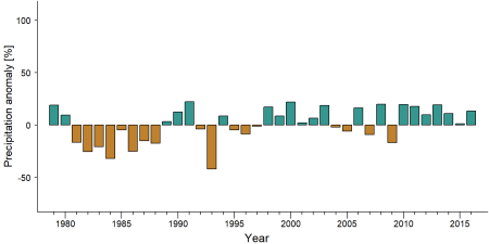
Precipitation anomaly inBong Mountain Proposed Protected Area -
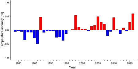
Temperature anomaly inBong Mountain Proposed Protected Area


External links
References
Christie T, Steining MK, John D, Peal A. 2007. Fragmentation and clearance of Liberia’s forests during 1986–2000. Oryx 41: 539–543.
Johnson S. 2015. Aggregated Biodiversity Offsets: A Roadmap for Liberia’s Mining Sector. Unpublished report by the World Bank Group (WBG) and Program On Forests (PROFOR).
Tweh C, Lormie M, Kouakou CY, Hillers A, Kühl HS, Junker J, et al. 2014. Conservation status of chimpanzees Pan troglodytes verus and other large mammals in Liberia: a nationwide survey. Oryx: http://dx.doi.org/10.1017/S0030605313001191.
Wilson STK, Wang H, Kabenge M, Qi X. 2017. The mining sector of Liberia: current practices and environmental challenges. Environmental Science and Pollution Research 24: 18711–18720.
Page created by: APES Atlas Team Date: 2019-09-23