
Rwenzori Mountains National Park
East Africa > Uganda > Rwenzori Mountains National Park
Français | Português | Español | Bahasa Indonesia | Melayu
Summary
- Eastern chimpanzees (Pan troglodytes schweinfurthii) are present in Rwenzori Mountains National Park.
- It has been estimated that 231 individuals occur in the site.
- The population trend is unknown.
- The site has a total size of 996 km².
- Key threats to chimpanzees are illegal logging, bushmeat hunting, and illegal resource harvesting.
- Conservation activities implemented include conducting anti-poaching patrols.
Site characteristics
Located in western Uganda, Rwenzori Mountains National Park comprises part of the Rwenzori mountain chain, including Africa's third highest peak, Mt Stanley's Margherita Peak at 5,109 m above sea level (UNESCO). The park is contiguous with the Virunga National Park in the Democratic Republic of the Congo (BirdLife International 2020). The region's glaciers, waterfalls and lakes make it one of the most fascinating afro-alpine areas.The park is known for its rich and unique flora; some of the world's rarest vegetation can be found here (UNESCO). Some unusual flora found here include the giant heather, and two species of forest tree, Hypericum bequaertii and Schefflera polysciadia, which are only known from Rwenzori (BirdLife International 2020; Uganda Wildlife Authority). In addition, the site is home to 70 mammals and 217 bird species, including 19 Albertine Rift endemics (UNESCO; BirdLife International 2020). Twenty-five invertebrate species from the area have been described in the last 15 years (BirdLife International 2020). Mammal species of conservation concern include the Rwenzori duiker (Cephalophus rubidus), forest elephants (Loxodonta cyclotis), eastern chimpanzees (Pan troglodytes schweinfurthii), Ruwenzori colobus (Colobus angolensis ruwenzorii) and L'Hoest's monkey (Cercopithecus l’hoesti); subspecies of blue monkey (Cercopithecus mitis) and rock hyrax (Procavia capensis) are only known from Rwenzori Mountains National Park (BirdLife International 2020).
Henry Stanley, an explorer, placed the Rwenzori in the map in 1888; he documented "Ruwenzori" as a local name meaning “rain-maker” or “cloud-king” (Uganda Wildlife Authority). Before that, the Rwenzoris were named “Mountains of the Moon” by the Alexandrine geographer Ptolemy in AD 150 (Uganda Wildlife Authority). Much later, in 1941, the site was declared a Forest Reserve; in 1991 it was gazetted as a National Park, and in 1995 it was declared a UNESCO World Heritage Site (Uganda Wildlife Authority). The park was designated as a Ramsar Site in 2008. The Rwenzori mountains are not volcanic, as other major mountains in East Africa, but they are a block of rock up-faulted through the floor of the Western Rift Valley. The site has been long known by mountaineers. The oldest person to reach Marguerita Peak was Ms. Beryl Park, aged 78 in 2010 (Uganda Wildlife Authority).
Table 1. Basic site information for Rwenzori Mountains National Park
| Species | Pan troglodytes schweinfurthii |
| Area | 996 km² |
| Coordinates | Lat: 0.363517 , Lon: 29.949944 |
| Type of site | Protected area (National Park) |
| Habitat types | Subtropical/tropical moist montane forest, Rocky areas (inland cliffs, mountain peaks), Wetlands (lakes, rivers, streams, bogs, marshes) |
| Type of governance |
Types of sites Governance types Habitat types
Ape status
Table 2. Ape population estimates reported for Rwenzori Mountains National Park
| Species | Year | Occurrence | Encounter or vistation rate (nests/km; ind/day) | Density estimate [ind./ km²] (95% CI) | Abundance estimate (95% CI) | Survey area | Sampling method | Analytical framework | Source | Comments | A.P.E.S. database ID |
|---|---|---|---|---|---|---|---|---|---|---|---|
| Pan troglodytes schweinfurthii | 2016 | 231.0 | Rwenzori Mountains National Park | Opportunistic observation | Makombo 2017 | ||||||
| Pan troglodytes schweinfurthii | 2010 | 0.385 | 384.0 | Rwenzori Mountains National Park | Line transects | Makombo 2017 | |||||
| Pan troglodytes schweinfurthii | 2000 | 0.506 | 500.0 | Rwenzori Mountains National Park | Reconnaissance walk | Makombo 2017 |
Sampling methods Analytical frameworks
Threats
The main threats to the park are illegal logging, bushmeat hunting, and illegal resource harvesting, especially of bamboo (UNESCO).
Table 3. Threats to apes reported for Rwenzori Mountains National Park
| Category | Specific threats | Threat level | Description | Year of threat |
|---|---|---|---|---|
| 5 Biological resource use | 5.1 Hunting & collecting terrestrial animals | Present (unknown severity) | Hunting for bushmeat (UNESCO). | Ongoing (2020) |
| 5 Biological resource use | 5.2 Gathering terrestrial plants | Present (unknown severity) | Harvesting plants, especially bamboo (UNESCO). | Ongoing (2020) |
| 5 Biological resource use | 5.3 Logging & wood harvesting | Present (unknown severity) | Illegal logging (UNESCO). | Ongoing (2020) |
Conservation activities
Table 4. Conservation activities reported for Rwenzori Mountains National Park
| Category | Specific activity | Description | Implementing organization(s) | Year of activity |
|---|---|---|---|---|
| 2 Counter-wildlife crime | 2.3 Conduct regular anti-poaching patrols | Anti-poaching patrols are conducted at the site (UNESCO). | 1991-Ongoing (2020) | |
| 5 Protection & restoration | 5.2 Legally protect ape habitat | The site was designated as a National Park in 1991. | 1991-Ongoing (2026) |
Challenges
Table 5. Challenges reported for Rwenzori Mountains National Park
| Challenges | Specific challenges | Source | Year(s) |
|---|---|---|---|
| Not reported |
Enablers
Table 6. Enablers reported for Rwenzori Mountains National Park
| Enablers | Specific enablers | Source | Year(s) |
|---|---|---|---|
| 1 Site management | |||
| 2 Resources and capacity | |||
| 3 Engaged community | |||
| 4 Institutional support | |||
| 5 Ecological context | |||
| 6 Safety and stability |
Research activities
Documented behaviours
Table 7. Behaviours documented for Rwenzori Mountains National Park
| Category | Behavior | Observation type | Prevalence | Observation dates | Source | Habituation | Species | Comment |
|---|---|---|---|---|---|---|---|---|
| Not reported |
Exposure to climate change impacts
As part of a study on the exposure of African great ape sites to climate change impacts, Kiribou et al. subm. extracted climate data and data on projected extreme climate impact events for the site. Climatological characteristics were derived from observation-based climate data provided by the Inter-Sectoral Impact Model Intercomparison Project (ISIMIP, www.isimip.org). Parameters were calculated as the average across each 30-year period. For 1981-2010, the EWEMBI dataset from ISIMIP2a was used. For the two future periods (2021-2050 and 2071-2099) ISIMIP2b climate data based on four CMIP5 global climate models were used. For future projections, two Representative Concentration Pathways (RCP) were used. RCP 2.6 is a scenario with strong mitigation measures in which global temperatures would likely rise below 2C. RCP 6.0 is a scenario with medium emissions in which global temperatures would likely rise up to 3C by 2100. For the number of days with heavy precipitation events, the 98th percentile of all precipitation days (>1mm/d) was calculated for the 1979-2013 reference period as a threshold for a heavy precipitation event. Then, for each year, the number of days above that threshold was derived. The figures on temperature and precipitation anomaly show the deviation from the mean temperature and mean precipitation for the 1979-2013 reference period.
The estimated exposure to future extreme climate impact events (crop failure, drought, river flood, wildfire, tropical cyclone, and heatwave) is based on a published dataset by Lange et al. 2020 derived from ISIMIP2b data. The same global climate models and RCPs as described above were used. Within each 30-year period, the number of years with an extreme event and the average proportion of the site affected were calculated (see Kiribou et al. subm. for details).
Table 8. Estimated past and projected climatological characteristics in Rwenzori Mountains National Park
| Value | 1981-2010 | 2021-2050, RCP 2.6 | 2021-2050, RCP 6.0 | 2071-2099, RCP 2.6 | 2071-2099, RCP 6.0 |
|---|---|---|---|---|---|
| Mean temperature [C] | 18.2 | 19.3 | 19.2 | 19.5 | 20.6 |
| Annual precipitation [mm] | 1182 | 1208 | 1282 | 1169 | 1333 |
| Max no. consecutive dry days (per year) | 14.5 | 19.5 | 23.2 | 22.3 | 21.8 |
| No. days with heavy precipitation (per year) | 6.4 | 6.6 | 8.4 | 6.7 | 11.1 |
Table 9. Projected exposure of apes to extreme climate impact events in Rwenzori Mountains National Park
| Type | No. of years with event (2021-2050, RCP 2.6) | % of site exposed (2021-2050, RCP 2.6) | No. of years with event (2021-2050, RCP 6.0) | % of site exposed (2021-2050, RCP 6.0) | No. of years with event (2070-2099, RCP 2.6) | % of site exposed (2070-2099, RCP 2.6) | No. of years with event (2070-2099, RCP 6.0) | % of site exposed (2070-2099, RCP 6.0) |
|---|---|---|---|---|---|---|---|---|
| Crop failure | 3 | 0.71 | 1.5 | 0.1 | 1.5 | 0.26 | 1.5 | 0.17 |
| Drought | 0 | 0 | 0 | 0 | 0 | 0 | 0 | 0 |
| Heatwave | 0 | 0 | 0 | 0 | 0 | 0 | 0 | 0 |
| River flood | 1 | 0.01 | 3 | 0.85 | 1 | 0.02 | 4.5 | 0.27 |
| Tropical cyclone | 0 | 0 | 0 | 0 | 0 | 0 | 0 | 0 |
| Wildfire | 30 | 1.34 | 30 | 1.15 | 29 | 1.22 | 29 | 0.78 |
-
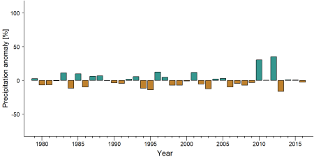
Precipitation anomaly in Rwenzori Mountains National Park -
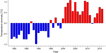
Temperature anomaly in Rwenzori Mountains National Park


External links
Rwenzori Mountains National Park UNESCO
Rwenzori Mountains National Park Ramsar
References
BirdLife International. (2020). Important Bird Areas factsheet: Ruwenzori (Rwenzori) Mountains National Park. Retrieved from http://www.birdlife.org on 16/12/2020.
Makombo, J. (2017). State of Conservation Report for Rwenzori Mountains National Park World Heritage Property –
Uganda. World Heritage Centre, UNESCO.
Page created by: APES Atlas Team Date: 2020-12-30