
Koumbia
West Africa > Republic of Guinea > Koumbia
Français | Português | Español | Bahasa Indonesia | Melayu
Summary
- Western chimpanzees (Pan troglodytes verus) are present in Koumbia.
- It has been estimated that more than 300 individuals occur in the area.
- The chimpanzee population trend is unknown.
- The site is not formally designated and consequently the size is unknown.
- Agriculture and roads are the most prevalent signs of human activities across Koumbia.
- As part of the AGIR project 42 conservation zones to establish community-based forest management were identified.
- Koumbia is transboundary with Guinea-Bissau.
Site characteristics
Koumbia is located in western Guinea in the prefecture Gaoual and is transboundary with Guinea-Bissau. The French colonial government declared Koumbia a National Park in 1933 (WCF 2012), but the site has no formal protective status at this point. Koumbia does not have a designated IUCN category nor is it listed in the World Database on Protected Areas (UNEP-WCMC and IUCN 2018).
During a survey of the Koumbia site in 2010 by the Wild Chimpanzee Foundation the presence of hippopotamus (Hippopotamus amphibius), jackals (Canis sp.), servals (Leptailurus serval), mona monkeys (Cercopithecus mona), green monkeys (Chlorocebus sabaeus), patas monkeys (Erythrocebus patas) and baboons (Papio sp.) was confirmed (WCF 2012).
Table 1. Basic site information for Koumbia
| Species | Pan troglodytes verus |
| Area | |
| Coordinates | Lat: 11.58 , Lon: -13.93 |
| Type of site | Unknown |
| Habitat types | Unknown |
| Type of governance |
Types of sites Governance types Habitat types
Ape status
In 1997, Rebecca Kormos (Ham 1998) conducted questionnaires and limited transect sampling around Moyerai (north of Koumbia), concluding that chimpanzees were present at relatively high density. In 2010, a more extensive systematic line-transect nest survey by the Wild Chimpanzee Foundation (WCF) delineated the Koumbia zone (bounded by Sentha River / Guinea-Bissau to the north, and Kongo / Boké-Gaoual road to the south) and estimated 296 individuals (95% CI: 164–532), with a density estimate of ~0.37 ind/km² (CI: 0.20–0.67) based on nest encounter rates (WCF 2012). To date, no published follow-up survey, camera-trap census, or genetic census has been found that updates this figure specifically for Koumbia.
Table 2. Ape population estimates reported for Koumbia
| Species | Year | Occurrence | Encounter or vistation rate (nests/km; ind/day) | Density estimate [ind./ km²] (95% CI) | Abundance estimate (95% CI) | Survey area | Sampling method | Analytical framework | Source | Comments | A.P.E.S. database ID |
|---|---|---|---|---|---|---|---|---|---|---|---|
| Pan troglodytes verus | 2010 | 0.37 (0.20-0.67) | 296 (164-532) | Area delineated by the river Kongo and the road Boké - Gaoual in the South and the river Sentha and the border with Guinea-Bissau in the North | Line transects | WCF 2012 | Total survey effort: 109.87 km | GIN0002, GIN0010 GIN0016, GIN0020, GIN0023, GIN0024, GIN0025, GIN0027, GIN0029, GIN0036, GIN0069
| |||
| Pan troglodytes verus | 1997 | Present | Koumbia village | Interviews | Ham 1998 | Questionnaire survey | GIN0021 | ||||
| Pan troglodytes verus | 1997 | Present | Moyerai (village to the North of Koumbia) | Line transects | Ham 1998 | Total survey effort: 5.2 km | GIN0021 |
Sampling methods Analytical frameworks
Threats
During the survey by the WCF 27 villages were identified in Koumbia with an estimated total population of 2,600 inhabitants (WCF 2012). The most prevalent threat was agriculture (0.46 signs/km) and the high number of roads shows that the site is strongly used by people (WCF 2012). Based on low encounter rates, the WCF concluded that wood extraction, poaching and human settlements likely pose only a minor threat to the wildlife in Koumbia (WCF 2012). However, it was noted that recently, hunters not belonging to the local villages entered the area to hunt bushmeat commercially for urban markets (WCF 2012).
More recently, the mining company Alliance Mining Commodities started developing a Bauxit mining site west of Koumbia. There are plans to build a road to the mining site and a port at the river Rio Nuñez (Alliance Mining Commodities 2018).
Table 3. Threats to apes reported for Koumbia
| Category | Specific threats | Threat level | Description | Year of threat |
|---|---|---|---|---|
| 1 Residential & commercial development | 1.1 Residential areas | Low (up to 30% of population affected) | Approximately 2,600 people live at the site but are estimated to pose only a minor threat to chimpanzees (WCF 2012) | Ongoing (2012) |
| 2 Agriculture & aquaculture | 2.1 Annual & perennial non-timber crops | High (more than 70% of population affected) | Signs of agriculture were the most prevalent sign of anthropogenic activity (WCF 2012) | Ongoing (2012) |
| 3 Energy production & mining | 3.2 Mining & quarrying | High (more than 70% of population affected) | Alliance Mining Commodities (EIA 2018) obtained exploration rights for bauxite near Koumbia. If operational, associated road construction and forest clearing could cause significant habitat fragmentation and disturbance to chimpanzees. Verification of current concession activity is recommended. (WCF 2012; Alliance Mining Commodities 2018) | 2018-Ongoing(2025) |
| 4 Transportation & service corridors | 4.1 Roads & railroads | High (more than 70% of population affected) | High number of roads was found at the site (WCF 2012), there are plans to build a new road to the west of the site to a mining site (Alliance Mining Commodities 2018) | Ongoing (2012) |
| 5 Biological resource use | 5.1 Hunting & collecting terrestrial animals | Medium (30-70% of population affected) | Poaching by people living at the site was estimated to pose only a minor threat to chimpanzees, but increasingly people from outside are entering the area for commercial hunting (WCF 2012), development of a mining site nearby and the associated population increase might increase wild meat demand | Ongoing (2012) |
| 5 Biological resource use | 5.3 Logging & wood harvesting | Low (up to 30% of population affected) | Wood extraction was estimated to pose only a minor threat to chimpanzees (WCF 2012) | Ongoing (2012) |
| 7 Natural system modifications | 7.1 Fire & fire suppression | Medium (30-70% of population affected) | Annual dry-season burning for land clearing and hunting damages understory vegetation and destroys chimpanzee nesting trees; observed in the landscape but not quantified previously. (WCF 2012) | 2012-Ongoing(2025) |
Conservation activities
The European funded AGIR project (Programme Régional d’Appui à la Gestion Intégrée des Ressources Naturelles des Bassins du Niger et de la Gambie) identified 42 conservation zones at this site with the aim of establishing community-based forest management (WCF 2012). AGIR was implemented until 2005 and also encompassed an environmental awareness raising scheme (WCF 2012).
Table 4. Conservation activities reported for Koumbia
| Category | Specific activity | Description | Implementing organization(s) | Year of activity |
|---|---|---|---|---|
| 7 Economic & other incentives | 7.2 Provide non-monetary benefits to local communities for sustainably managing their forest and its wildlife (e.g., better education, infrastructure development) | AGIR identified 42 conservation zones to establish community-based forest management (WCF 2012) | 2005 |
Challenges
Table 5. Challenges reported for Koumbia
| Challenges | Specific challenges | Source | Year(s) |
|---|---|---|---|
| 2 Resources and capacity | 2.3 General lack of funding | Wild Chimpanzee Foundation (WCF) 2012 | Ongoing (2012) |
| 2 Resources and capacity | 2.6 Lack of biomonitoring/survey data | WCF 2012; Ham 1998 | 2010-Ongoing (2024) |
| 2 Resources and capacity | 2.7 Lack of infrastructure | Wild Chimpanzee Foundation (WCF) 2012 | Ongoing (2012) |
| 4 Institutional support | 4.3 Lack of protected area status | WCF 2012; UNEP-WCMC 2018 | 2012-Ongoing (2024) |
| 4 Institutional support | 4.4 Lack of transboundary cooperation | Wild Chimpanzee Foundation (WCF) 2012 | Ongoing (2012) |
Enablers
Table 6. Enablers reported for Koumbia
| Enablers | Specific enablers | Source | Year(s) |
|---|---|---|---|
| 1 Site management | |||
| 2 Resources and capacity | |||
| 3 Engaged community | |||
| 4 Institutional support | |||
| 5 Ecological context | |||
| 6 Safety and stability |
Research activities
From 1996 to 1997 Rebecca Kormos (née Ham) did a nationwide surveys on chimpanzees across Guinea and also surveyed parts of Koumbia (Ham 1998). As part of their nationwide inventory of chimpanzee populations in Guinea the Wild Chimpanzee Foundation surveyed Koumbia in 2010 (WCF 2012).
Documented behaviours
Table 7. Behaviours documented for Koumbia
| Category | Behavior | Observation type | Prevalence | Observation dates | Source | Habituation | Species | Comment |
|---|---|---|---|---|---|---|---|---|
| Not reported |
Exposure to climate change impacts
As part of a study on the exposure of African great ape sites to climate change impacts, Kiribou et al. (2024) extracted climate data and data on projected extreme climate impact events for the site. Climatological characteristics were derived from observation-based climate data provided by the Inter-Sectoral Impact Model Intercomparison Project (ISIMIP, www.isimip.org). Parameters were calculated as the average across each 30-year period. For 1981-2010, the EWEMBI dataset from ISIMIP2a was used. For the two future periods (2021-2050 and 2071-2099) ISIMIP2b climate data based on four CMIP5 global climate models were used. For future projections, two Representative Concentration Pathways (RCP) were used. RCP 2.6 is a scenario with strong mitigation measures in which global temperatures would likely rise below 2C. RCP 6.0 is a scenario with medium emissions in which global temperatures would likely rise up to 3C by 2100. For the number of days with heavy precipitation events, the 98th percentile of all precipitation days (>1mm/d) was calculated for the 1979-2013 reference period as a threshold for a heavy precipitation event. Then, for each year, the number of days above that threshold was derived. The figures on temperature and precipitation anomaly show the deviation from the mean temperature and mean precipitation for the 1979-2013 reference period.
The estimated exposure to future extreme climate impact events (crop failure, drought, river flood, wildfire, tropical cyclone, and heatwave) is based on a published dataset by Lange et al. 2020 derived from ISIMIP2b data. The same global climate models and RCPs as described above were used. Within each 30-year period, the number of years with an extreme event and the average proportion of the site affected were calculated (Kiribou et al. 2024).
Table 8. Estimated past and projected climatological characteristics in Koumbia
| Value | 1981-2010 | 2021-2050, RCP 2.6 | 2021-2050, RCP 6.0 | 2071-2099, RCP 2.6 | 2071-2099, RCP 6.0 |
|---|---|---|---|---|---|
| Mean temperature [C] | 26.8 | 28 | 27.8 | 28.2 | 29.7 |
| Annual precipitation [mm] | 1531 | 1443 | 1398 | 1499 | 1308 |
| Max no. consecutive dry days (per year) | 125.8 | 124.6 | 125.1 | 125.8 | 130.6 |
| No. days with heavy precipitation (per year) | 3.5 | 4.9 | 5 | 5.2 | 3.9 |
Table 9. Projected exposure of apes to extreme climate impact events in Koumbia
| Type | No. of years with event (2021-2050, RCP 2.6) | % of site exposed (2021-2050, RCP 2.6) | No. of years with event (2021-2050, RCP 6.0) | % of site exposed (2021-2050, RCP 6.0) | No. of years with event (2070-2099, RCP 2.6) | % of site exposed (2070-2099, RCP 2.6) | No. of years with event (2070-2099, RCP 6.0) | % of site exposed (2070-2099, RCP 6.0) |
|---|---|---|---|---|---|---|---|---|
| Crop failure | 5 | 0.94 | 3.5 | 0.94 | 4.5 | 0.94 | 7.5 | 0.94 |
| Drought | 2.75 | 100 | 1.5 | 100 | 1.5 | 50 | 3 | 100 |
| Heatwave | 2 | 50 | 1 | 100 | 1 | 50 | 2 | 100 |
| River flood | 0.25 | 0.03 | 0.5 | 0.01 | 1 | 2.21 | 1 | 2.23 |
| Tropical cyclone | 0.5 | 0.03 | 0 | 0 | 1 | 0.53 | 0 | 0 |
| Wildfire | 30 | 1.75 | 30 | 1.73 | 29 | 2.16 | 29 | 2.34 |
-
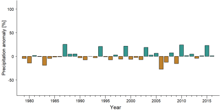
Precipitation anomaly in Koumbia -
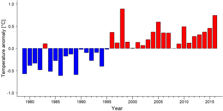
Temperature anomaly in Koumbia


External links
References
Alliance Mining Commodities. (2018). Koumbia Bauxite Project: Environmental and Social Impact Assessment (ESIA). Alliance Mining Commodities Ltd. Retrieved from https://allianceminingcommodities.com/
Brugiere, D., Badjinca, I., Silva, C., & Serra, A. (2009). Distribution of Chimpanzees and Interactions with Humans in Guinea-Bissau and Western Guinea, West Africa. Folia Primatologica, 80(5), 353-358. doi:10.1159/000259335
Junker, J., Kühl, H. S., Boesch, C., Campbell, G., du Toit, L., & Maisels, F. (2024). The impact of industrial mining and infrastructure expansion on great apes in West Africa. Conservation Science and Practice, 6(3). doi:10.1111/csp2.2398
Ham R. 1998. Nationwide chimpanzee census and large mammal survey Republic of Guinea, PhD thesis, 286 p.
UNEP-WCMC, IUCN. 2018. Protected Planet: The World Database on Protected Areas (WDPA), Cambridge, UK: UNEP-WCMC and IUCN Online: www.protectedplanet.net link
WCF. 2012. Etat de la faune et des menaces dans les aires protégées terrestres et principales zones de forte biodiversité de Rep. de Guinée. Report. Wild Chimpanzee Foundation, Sangaredi, Republic of Guinea. Online: Wild Chimpanzee Foundation
Kiribou, R., Tehoda, P., Chukwu, O., Bempah, G., Kühl, H. S., Ferreira, J., …, & Heinicke, S. (2024). Exposure of African ape sites to climate change impacts. PLOS Climate, 3(2), e0000345. doi:10.1371/journal.pclm.0000345
Page created by: APES Atlas Team Date: 2019-01-02
Page updated by: Onella Mundi Date: 2025-10-14